Red Willow County lies in southwestern Nebraska, where McCook anchors a broad rural county and the Republican River crosses the northern half of the landscape. This Red Willow County Map page brings together the county boundary and roads, the locations of McCook, Indianola, Bartley, Danbury, and Lebanon, named rivers and creeks, and an elevation view that makes the low river valleys and higher western ground easy to compare. The WebP images are designed for quick viewing, while the download box below provides the same maps as high-resolution JPG files in one ZIP archive.
McCook and the Republican River are the easiest reference points for reading the county. McCook sits in the west-central part of Red Willow County, with Indianola and Bartley extending eastward along the same general corridor. Danbury and Lebanon are much farther south. Moving between the road, water, and elevation maps shows how those settlements relate not only to one another but also to the river valley, smaller tributaries, and the higher terrain away from the main valley.
Table of Contents
McCook, Indianola, Bartley, and the main road corridor
The general county map immediately establishes McCook as the most prominent place. U.S. 6 and U.S. 34 cross the McCook area and continue east toward Indianola and Bartley, giving the northern part of the county a clear east-west frame. Numerous local roads branch north and south from that corridor. The map is especially useful for seeing how the three northern communities relate to the county boundary before looking at the more detailed water and elevation patterns.
Local route numbers such as 380, 394, 398, 401, 403, 407, 720, and 724 appear across the map, helping distinguish rural road segments that would otherwise look similar. Their presence does not make this a live navigation product, however. Construction, closures, seasonal road conditions, and routing can change after a static map is produced, so drivers should pair this regional reference with current navigation or Nebraska transportation information when planning an actual trip.
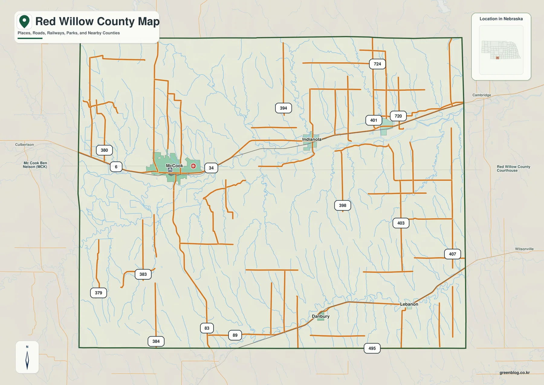
Southern Red Willow County has a different settlement pattern. Danbury is south of the central part of the county, while Lebanon lies farther southeast, with rural roads connecting the two through an area crossed by many smaller drainage lines. That separation matters because the county is not simply a single line of communities extending from McCook. The map instead shows a northern river-and-highway corridor and a second set of smaller communities spread across the southern countryside.
The official Red Willow County website identifies McCook as the county seat and lists Bartley, Danbury, Indianola, Lebanon, and McCook among the county’s incorporated municipalities. That official list matches the main places emphasized in the supplied maps. Background labels such as Culbertson, Cambridge, and Wilsonville help orient the reader to the surrounding region, but the dark county boundary should be used to distinguish places inside Red Willow County from nearby communities beyond it.
A simpler view of the county’s main communities
The city-connections map removes much of the road detail and focuses on five major places. McCook is the hub in the west, Indianola and Bartley continue eastward, and Danbury and Lebanon form the southern pair. This simplified arrangement is helpful when the goal is to learn relative position rather than individual road numbers. It also makes the wide spacing between the northern river corridor and the southern communities much more obvious than it is on a busier general map.
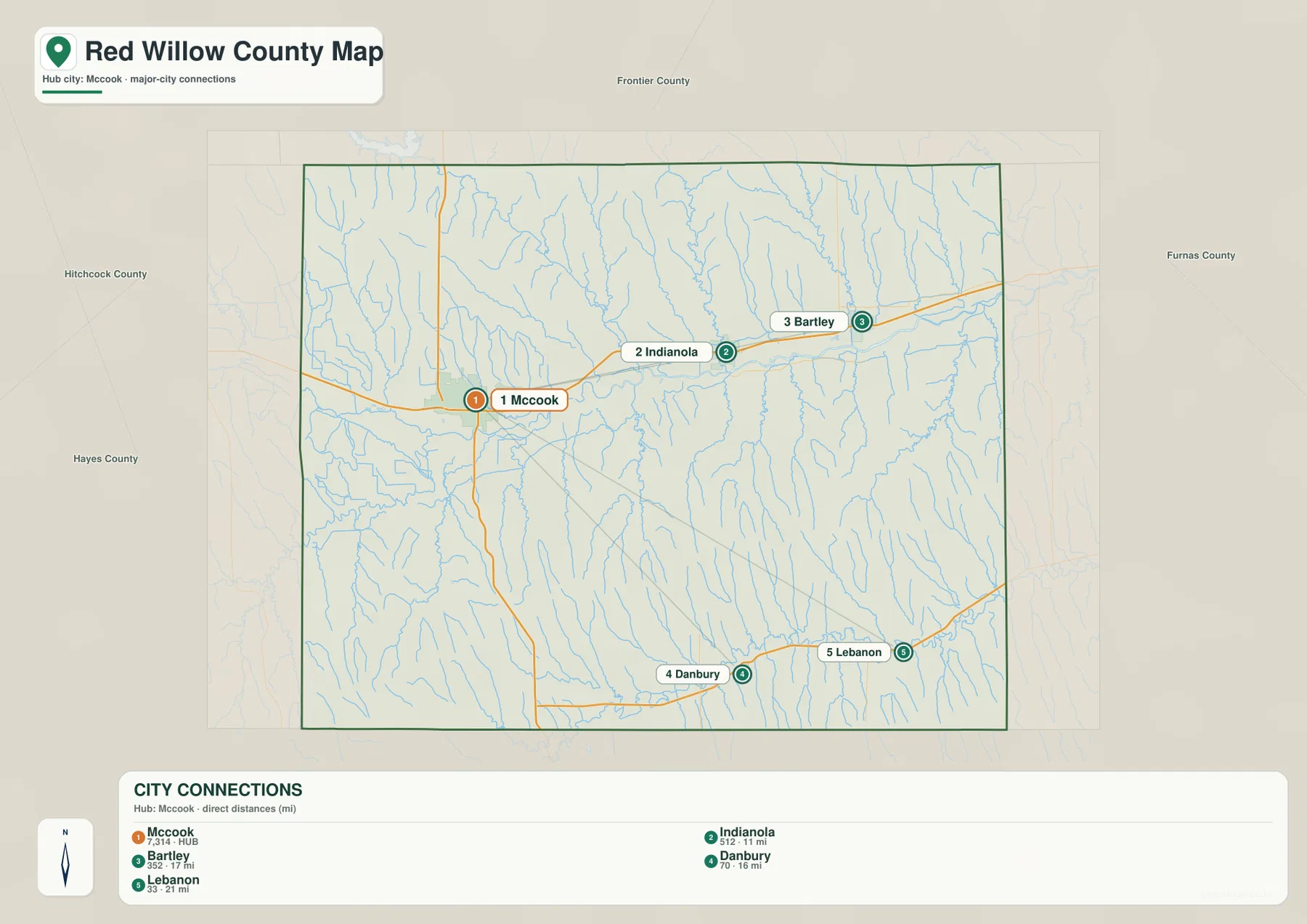
The CITY CONNECTIONS panel uses direct distances from McCook. Those values are straight-line distances between points, not driving distances along the road network. A town that appears close to McCook on this graphic may require a longer trip once road alignment, intersections, river crossings, and available routes are considered. The map is therefore best used to compare direction and general spacing, while a current road map or navigation service should be used for travel time and route selection.
Seen together, the five points show that settlement is dispersed rather than concentrated in one cluster. McCook, Indianola, and Bartley form a recognizable east-west sequence near the Republican River, while Danbury and Lebanon stand apart in the south. For classroom or reference use, a useful sequence is to identify the five places here first, return to the general map for roads, and then use the water map to see which river and creek valleys lie between them.
Red Willow County’s official profile reports a 2020 Census population of 10,702 and identifies McCook as the county seat. Population figures give useful context, but the purpose of this page is primarily geographic: it shows where the communities are and how they sit within the county. Readers who need current population estimates or a precise legal classification of a municipality should consult the latest Census and county records rather than treating labels on a static map as a current statistical table.
The Republican River and its network of creeks
The water map is dominated by the Republican River, which enters from the west and winds eastward across the northern half of Red Willow County. Its broad course passes south of McCook and continues toward the Indianola and Bartley area. Several smaller streams approach it from both north and south. Comparing this map with the settlement map makes the relationship especially clear: McCook, Indianola, and Bartley all sit close to the county’s principal river corridor.
Red Willow Creek descends from the northwestern part of the county toward the Republican River. Farther east, Coon Creek and Dry Creek cut southward through the uplands, while Silver Creek is prominent in the eastern part of the county. Beaver Creek crosses the southern section in a separate valley, and names such as Driftwood Creek and Brushy Creek appear among the smaller tributaries. The many thin blue lines show that the landscape is dissected by numerous minor channels in addition to the better-known streams.
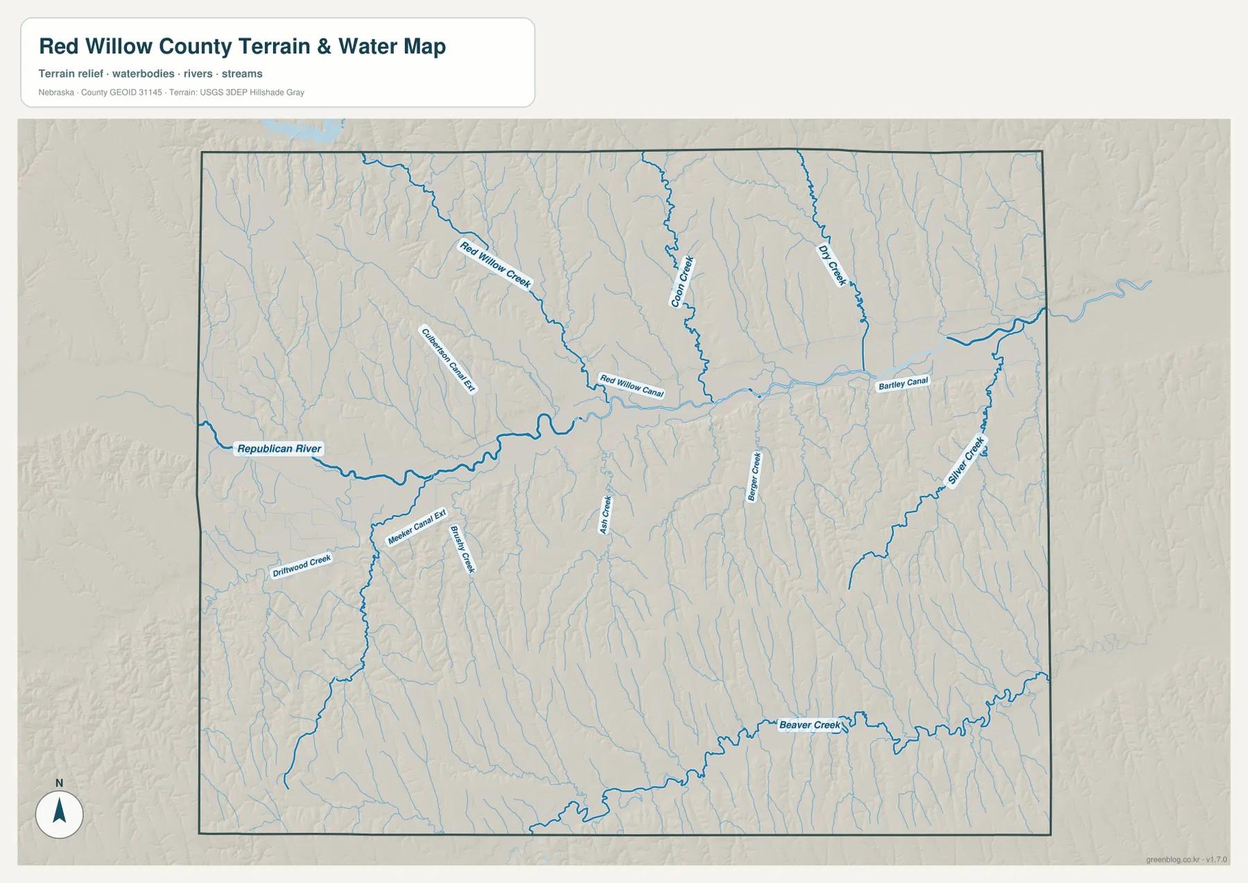
The map also labels Red Willow Canal and Bartley Canal, as well as Meeker Canal Ext and Riverside Canal East near the McCook area. These features are useful reminders that the blue network includes managed water conveyance as well as natural streams. The image does not show current operating status, water rights, diversion schedules, or canal capacity. Anyone researching those subjects should use current records from the relevant water-management agencies rather than inferring operational conditions from the map alone.
Line width and color should not be interpreted as a measurement of discharge, depth, or flood danger. This is a regional reference showing where named waterways are located. Floodplain decisions, land restrictions, stream access, and safety questions require current official products from agencies responsible for those topics. For general geography, however, the map is effective because it places the Republican River, Red Willow Creek, Beaver Creek, and the eastern tributaries into one consistent county-wide view.
Low river valleys against higher western terrain
The elevation map gives Red Willow County a very different appearance. The Republican River valley forms a long dark-green band across the northern half of the county, while the west and southwest contain more yellow, orange, and brown tones. The map reports an actual elevation range of roughly 692 to 892 meters and a mean near 781 meters. Those numbers are useful context, but the strongest visual message is the contrast between the low river corridor and the higher ground away from it.
Red Willow Creek and Coon Creek create narrow lower corridors that descend toward the Republican River, while the Beaver Creek valley forms another green band across the south. Between these valleys, the terrain is cut by many small ravines and ridges. The transition can be fairly abrupt in western Red Willow County, where higher ground sits close to deeply incised tributary valleys. This helps explain why the water map contains so many small channels even though the county may look broadly open on a simple road map.
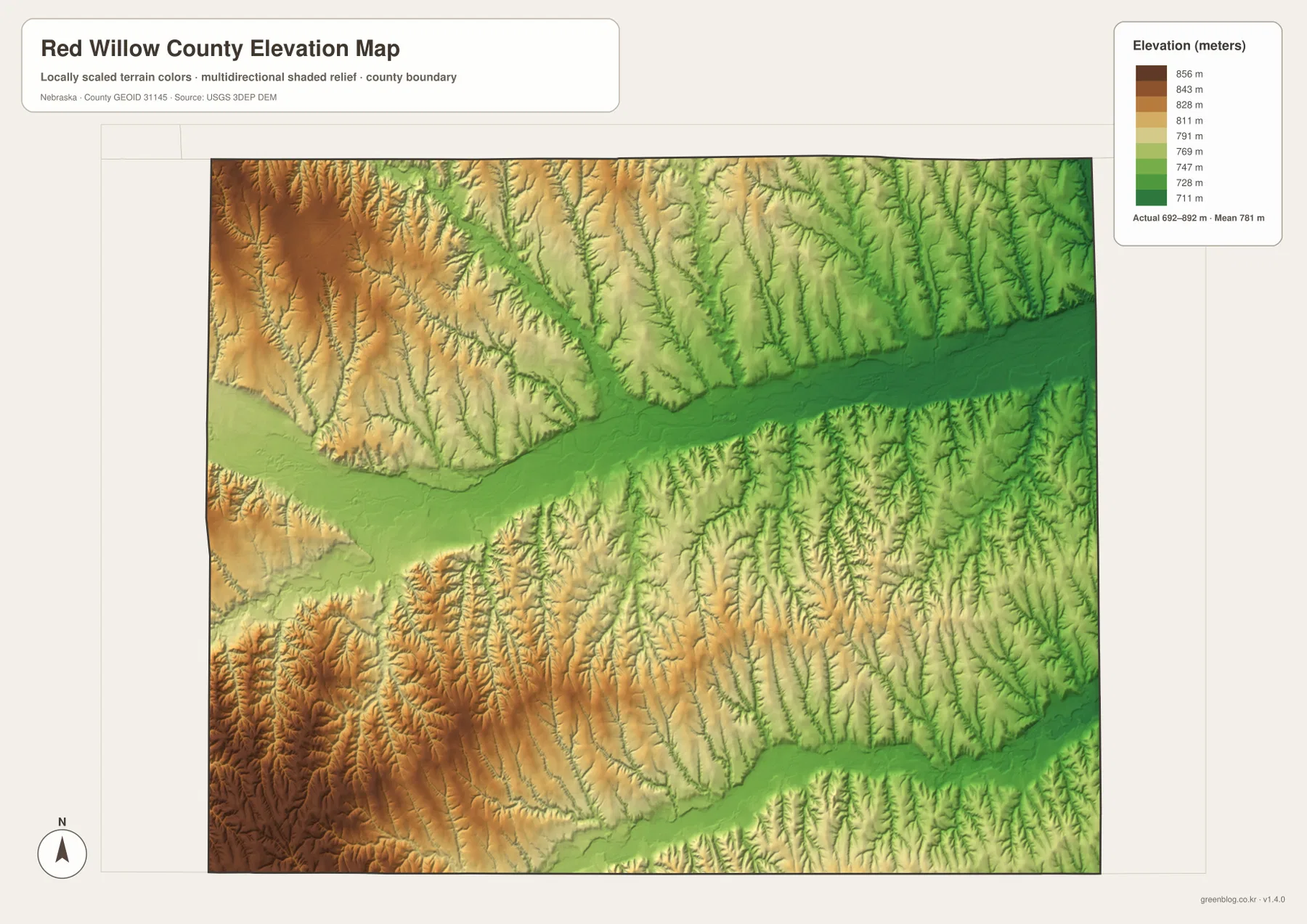
The western edge contains some of the broadest areas of higher terrain, and the southwest shows a dense pattern of ridges and narrow valleys. Eastern Red Willow County is generally lower, although Silver Creek and other streams still carve distinct lower corridors through the surrounding land. Looking at these differences region by region is more informative than treating the county’s mean elevation as if it described every place equally.
This elevation surface is intended for county-scale comparison, not parcel-level measurement. It should not be used to establish a survey elevation, road grade, building benchmark, or engineering design value. Those purposes require the underlying USGS elevation data, professional surveying, or another appropriate authoritative source. For education, regional orientation, and map-based comparison, the image works well because the river valleys and higher uplands are immediately distinguishable.
County history, agriculture, and the role of McCook
The county’s official history notes that Red Willow County was established in 1873 and took its name from Red Willow Creek. That connection is easy to visualize on the water map, where the creek runs from the north toward the Republican River. Linking the administrative name to a visible natural feature makes the county easier to remember and also shows why local history and physical geography often overlap in place names across the Great Plains.
McCook was founded in 1882 as a railroad town and developed into a regional center for transportation and commerce, according to the county’s official profile. The current general map does not reconstruct historic rail lines, but it does show McCook as the most prominent settlement and a place where important routes converge. That makes the modern map a useful starting point for historical research: locate present-day McCook first, then compare it with older railroad, town, or county records when studying change over time.
The official county profile also states that about 92 percent of the land is agricultural, including pasture, dryland crops, and irrigated crops. The supplied maps are not land-cover maps, so they do not identify individual fields or classify agricultural parcels. What they do show is the broad rural setting, the spacing of communities, the river and creek valleys, and the road network that connects those places. Those geographic elements provide context without making claims about the use of any particular property.
Indianola, Bartley, Danbury, and Lebanon are much smaller than McCook, but they remain important reference points for understanding the county as a whole. The northern communities are closely associated with the Republican River corridor, while the southern pair sits among a different set of creek valleys. Switching between the city, water, and elevation maps reveals those contrasts more clearly than a single list of place names can.
Using the maps for printing, classes, and regional reference
For a first overview, the general county map is the most useful starting point because it combines roads, settlements, nearby place labels, and the county outline. Find McCook first, follow U.S. 6 and U.S. 34 east toward Indianola and Bartley, and then compare the southern positions of Danbury and Lebanon. That sequence provides a practical mental framework before moving to maps that emphasize waterways or terrain.
The city-connections map works best when the question is simply where the major communities lie relative to one another. The water map is better for locating the Republican River, Red Willow Creek, Silver Creek, Beaver Creek, and the named canals. The elevation map answers a different question by showing which broad areas are low or high. Choosing the map that matches the question first reduces clutter and makes it easier to use the other maps as supporting references.
In a classroom exercise, students can identify the five communities on the city map, trace the Republican River on the water map, and then locate the same river valley as a dark-green lowland on the elevation map. For regional comparison, readers can contrast the low McCook river corridor with the higher western and southwestern uplands. The high-resolution JPG files are also better suited to printing or zooming than the WebP previews when small labels and road numbers matter.
These maps are general geographic references rather than legal or safety documents. They do not replace parcel records, professional surveys, official flood maps, emergency routing, or current road-condition services. County boundaries can be checked against Census TIGER/Line data, waterways against USGS National Hydrography, and elevation against the USGS 3D Elevation Program. Using the maps with those current sources keeps the page useful without asking a static image to answer questions it was not designed to resolve.
Frequently Asked Questions
Which map is best for comparing McCook, Indianola, and Bartley?
The city-connections map gives the simplest comparison because it shows the communities as clearly separated points with McCook as the hub. Use the general county map when you also need road numbers and surrounding routes. Remember that the distances in the city panel are straight-line distances, not driving distances.
Where can I see the Republican River and Red Willow Creek?
The water map shows both most clearly. The Republican River crosses the northern half of the county from west to east, while Red Willow Creek descends from the north toward it. Coon Creek, Dry Creek, Silver Creek, Beaver Creek, and several named canals are also labeled on the same map.
Can the elevation map be used for surveying or construction design?
No. It is a county-scale reference for comparing the low river valleys with higher surrounding terrain. Survey elevations, road grades, building benchmarks, and engineering design require appropriate USGS source data, professional surveys, or other authoritative technical records.
Map File Information
Download the four high-resolution JPG maps shown on this page for Red Willow County in one ZIP archive.
- Included Files: Use only the versions confirmed in the article and supplied images
- File Type: Use the confirmed download contents
- Intended Use: Printing, education, presentations, and map-based projects
Related Maps
Sources and references
County-seat, municipality, history, and agricultural background comes from the official Red Willow County website. The federal sources below provide authoritative references for boundaries, hydrography, and elevation data.
- Red Willow County – About Our County
- U.S. Census Bureau – TIGER/Line Shapefiles
- USGS – National Hydrography
- USGS – 3D Elevation Program
Green Map creates custom-edited map images using open geographic data sources such as geoBoundaries, Natural Earth, OpenStreetMap, and government open data. These maps are edited visual materials, not raw data files, and are provided for education, documents, presentations, and graphic reference.