Polk County lies in east-central Nebraska, with Osceola and Stromsburg providing two of the easiest reference points for understanding the county. This Polk County Nebraska Map page brings together the county boundary, major highways, the locations of Osceola, Stromsburg, Shelby, and Polk, the Platte and Big Blue river systems, and the change in elevation from the higher southwest to the lower northern river corridor. The WebP images are quick on-page previews, while the download box below provides the same maps as high-resolution JPG files in one ZIP archive.
A useful way to begin is to locate Osceola, the county seat, and then look south toward Stromsburg. Highway 92 runs east-west across much of the county, Highway 39 provides a strong north-south reference through the interior, and U.S. 81 follows the eastern side. Together, those roads make it easier to place the main communities before moving on to the rivers and terrain.
Table of Contents
Osceola and Stromsburg anchor the central part of the county
On the general county map, Osceola sits slightly east of center. Highway 130 approaches from the west, while Highway 131 continues toward Shelby and the eastern side of the county. Stromsburg is south of Osceola, making the two communities a simple vertical reference for the county interior. This arrangement is especially useful when reading a printed map because the central roads are easy to follow even at a reduced size.
The village of Polk appears in the southwest, where Highways 66, 123, and 27 help define the southern road pattern. The western and northwestern parts of the county show fewer major community labels, while the northern boundary bends rather than following a simple straight line. That irregular edge sits close to the Platte River, so the boundary makes more sense when the road and water maps are considered together.
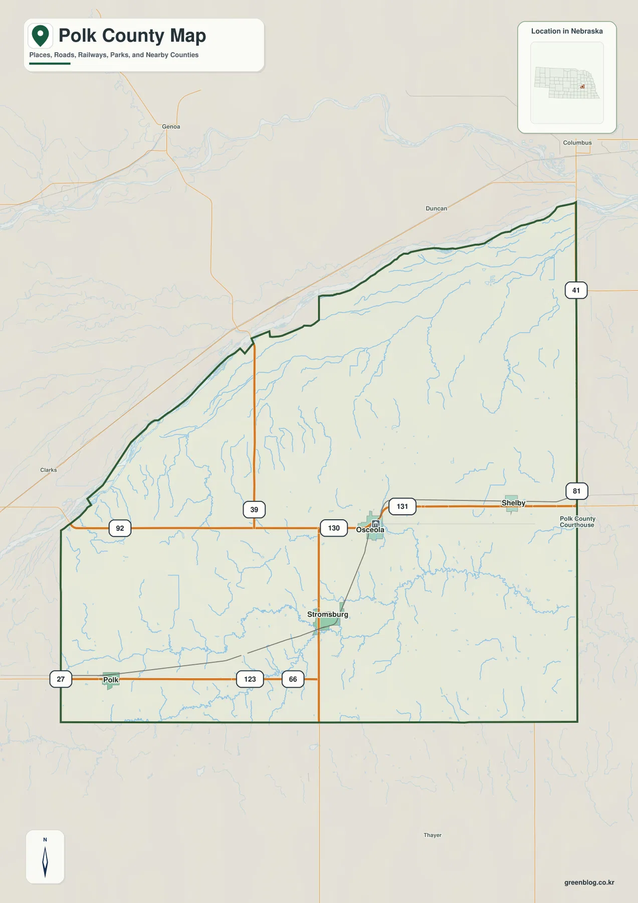
Several nearby places outside the county also appear in the background, including Columbus, Duncan, Genoa, and Clarks. Those labels are useful for regional orientation, but they should not be mistaken for places inside Polk County. The dark county outline remains the best guide for membership, and a legal or administrative boundary question should always be checked against an official source such as Census Bureau TIGER/Line data.
The official Polk County history identifies Osceola as the county seat and explains that the present county was organized in 1870. That background matches the map well: Osceola appears as a central administrative reference point rather than simply another place name. This page does not attempt to reproduce every county record, but the official information helps explain why Osceola is a useful starting point for reading the map.
A compact view of Stromsburg, Osceola, Shelby, and Polk
The city-connection map strips away much of the road detail and concentrates on four communities. Stromsburg is used as the hub, Osceola lies to the northeast, Shelby farther east, and Polk to the southwest. The result is a cleaner picture of settlement distribution, showing that the principal communities are spread across the southern and central parts of the county rather than clustered in one corner.
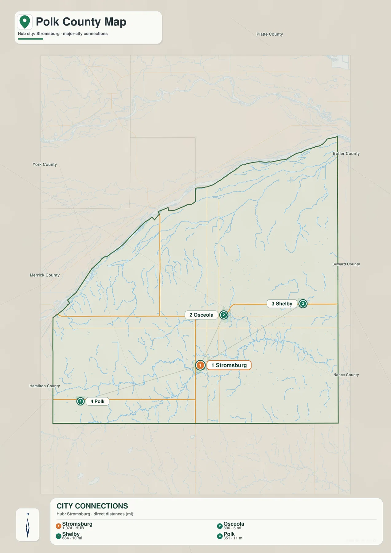
The map also gives direct-distance labels from Stromsburg: about 5 miles to Osceola, 10 miles to Shelby, and 11 miles to Polk. Those numbers are useful for quick scale, but they are not driving distances. Actual travel depends on the road network, intersections, construction, and other conditions, so the general county map or current navigation information should be used when planning a trip.
Polk County’s official information and the Nebraska Association of County Officials both identify Osceola, Stromsburg, Shelby, and Polk among the county’s main incorporated communities. That makes the simplified city map a practical companion to the more detailed road map. A student or visitor can learn the four names first, then return to the general map to see how the highways connect them.
Population figures printed on a map can become outdated, so the value of this image is primarily geographic. It answers where the communities sit and how their positions compare. Anyone who needs current population totals or municipal classifications should use the latest Census or official county records rather than treating the map labels as a live statistical source.
The Platte River edge and a different set of southern streams
Water features create one of the clearest contrasts in Polk County. The Platte River runs close to much of the northern edge, with the South Channel Platte River visible along part of the same corridor. Silver Creek is labeled toward the northwest, and nearby features outside the county include Loup River canals and Barnum Creek. These names help place Polk County within a broader network of Platte River channels and nearby waterways.
Farther south, Clear Creek crosses the western and central interior, while Davis Creek stretches across the middle toward the east. Prairie Creek occupies the southwest, and the Big Blue River becomes a major feature in the southern and southeastern part of the county. Numerous unnamed or smaller tributaries branch through the interior, showing that the water landscape is much more detailed than the two major river names alone suggest.
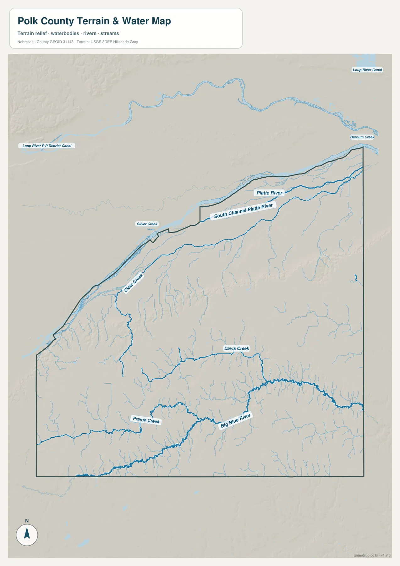
The northern river and the county boundary often run in similar directions, but they should not be assumed to be the same line everywhere. This map is designed for county-scale orientation, not legal boundary determination, flood-zone decisions, water-right questions, or channel-depth information. Those uses require current records from the appropriate agencies.
Viewing the towns together with the waterways makes the county easier to understand. Osceola and Stromsburg are south of the Platte corridor, while the Big Blue River lies farther south and east. Clear Creek and Davis Creek cut across the interior countryside, and their positions help explain some of the lower valleys that are much more visible on the elevation map.
Higher southwest ground descends toward the northern river corridor
The elevation map shows a strong color contrast between the southwest and the north. Brown shades dominate the higher southwestern ground, while greens become broader near the Platte River corridor. The map lists an actual elevation range of roughly 439 to 543 meters and a mean near 498 meters. The regional pattern matters more than any single number: the county generally drops toward the northern river area.
The higher southwest is not a featureless surface. Shaded relief reveals small valleys, ridges, and creek cuts, and several lower green corridors extend into the middle and eastern parts of the county. Davis Creek and the Big Blue River occupy some of these lower routes, so the water and elevation maps reinforce each other when viewed side by side.
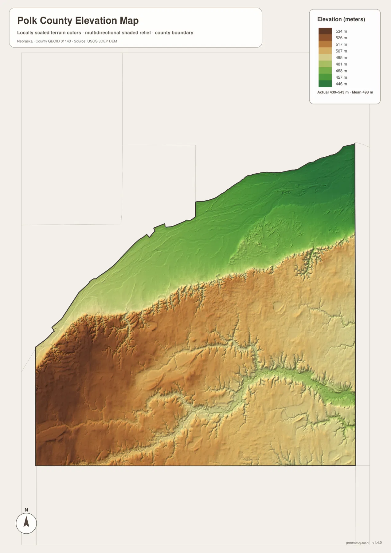
The broad green band in the north is one of the easiest features to recognize, but lower terrain also follows stream valleys farther south. As the colors shift to yellow and brown across the western and southern interior, the relief becomes more visibly cut by narrow drainage lines. This makes the elevation image useful for explaining why a road map alone does not fully describe the county’s landscape.
This image is a generalized county-scale elevation reference. It is not survey-grade data and should not be used to establish parcel elevations, construction benchmarks, road grades, or engineering drainage. Those tasks require source elevation data such as the USGS 3D Elevation Program and, where necessary, professional surveying. For classroom use, regional comparison, and printing, the map is valuable because the broad height differences are immediately visible.
Osceola as county seat and the local background behind the map
According to Polk County’s official history, the present county was organized in 1870 and Osceola was selected as county seat by local vote in 1871. The county was named for James K. Polk, the eleventh president of the United States. Those facts give the modern map useful context: Osceola’s role is administrative as well as geographic, and its central position makes it an effective reference point for the rest of the county.
The county history also describes earlier courthouse buildings and the construction of the present courthouse in the early 1920s. The current county website lists the courthouse at 400 Hawkeye Street in Osceola. None of the maps on this page are historical maps, so they should not be used to reconstruct former buildings, rail lines, or past boundaries. They are best used to locate present-day places before consulting historical records for change over time.
The Nebraska Association of County Officials describes Polk County as covering about 439 square miles and lists Osceola, Stromsburg, Shelby, and Polk among its incorporated communities. Those names match the four places highlighted on the city map. Keeping the article centered on these visible places avoids turning a map page into an unrelated directory while still giving enough local context to make the geography meaningful.
Which map works best for the question you have?
Use the general county map when you need several kinds of information at once. Highway 92 is the clearest east-west reference, Highway 39 organizes the center, and U.S. 81 marks the eastern side. Osceola, Stromsburg, Shelby, and Polk can all be placed against those roads, while nearby county and city labels provide broader regional orientation.
The city map is better when the goal is simply to compare the main communities without the detail of every road and stream. Choose the water map when the Platte River, Big Blue River, Prairie Creek, Clear Creek, or Davis Creek is the main subject. The elevation map is the clearest choice for comparing the higher southwest with the lower northern river corridor.
Using the maps in sequence can reveal relationships that are easy to miss on a single page. First locate Osceola and Stromsburg on the road map, then switch to the water map to see how streams pass through the interior, and finally compare the elevation colors to understand why the northern river corridor is lower. That sequence is particularly helpful for students or readers who are not already familiar with east-central Nebraska.
The downloadable JPG originals are 3638×2572 pixels each, so they are better suited to printing and enlargement than the WebP previews. High resolution does not make them legal boundary surveys, flood determinations, emergency navigation products, or engineering plans. Whenever a decision depends on exact current conditions, use the appropriate official source alongside the maps on this page.
Frequently Asked Questions
Which map is easiest for comparing Osceola and Stromsburg?
The city-location map is the quickest option because it uses Stromsburg as the hub and places Osceola to the northeast, Shelby farther east, and Polk to the southwest. For actual road connections, pair it with the general county map, which shows Highways 92, 39, 130, 131, and U.S. 81.
Where are the Platte River and Big Blue River easiest to see?
The terrain and water map shows both most clearly. The Platte River follows the northern side of the county, while the Big Blue River crosses the southern and southeastern area. Prairie Creek, Clear Creek, Davis Creek, Silver Creek, and the South Channel Platte River are also labeled on the same map.
What is the main elevation pattern in Polk County?
The southwest is generally higher, while the broad corridor near the Platte River in the north is lower. The map lists an actual elevation range of about 439 to 543 meters. Stream valleys create additional lower corridors across the interior, so the county is not simply a smooth slope from one side to the other.
Map File Information
Download the high-resolution Polk County JPG maps shown on this page in one ZIP file.
- Included Files: Use only the versions confirmed in the article and supplied images
- File Type: Use the confirmed download contents
- Intended Use: Printing, education, presentations, and map-based projects
Related Maps
Sources and references
County-seat and history details were checked against Polk County and City of Osceola official pages, while the Nebraska Association of County Officials provides additional county context. Census Bureau and USGS resources are useful reference sources for boundary, hydrography, and elevation data.
- Polk County Nebraska – About
- City of Osceola – History
- Nebraska Association of County Officials – Polk County
- U.S. Census Bureau – TIGER/Line Shapefiles
- USGS – National Hydrography
- USGS – 3D Elevation Program
Green Map creates custom-edited map images using open geographic data sources such as geoBoundaries, Natural Earth, OpenStreetMap, and government open data. These maps are edited visual materials, not raw data files, and are provided for education, documents, presentations, and graphic reference.