Nuckolls County sits along Nebraska’s southern border, with Superior near the south edge, Nelson closer to the center, Lawrence in the northwest, and several smaller communities spread across the eastern half of the county. This Nuckolls County Map set brings together county boundaries, roads, settlement locations, the Little Blue River and its tributaries, and the change from higher western ground to lower river and border valleys. The WebP images on the page are designed for quick viewing, while the download box below provides the same four maps as high-resolution JPG files in one ZIP archive.
Two places make useful anchors when reading the maps: Nelson and Superior. Nelson is inland and close to Nebraska Highway 14, which runs north to south through the county, while Superior lies near the southern boundary in a noticeably lower part of the terrain. Lawrence occupies the northwest side, Oak lies to the northeast, Ruskin is farther east, and Hardy is close to the southeastern edge. Instead of one dominant urban corridor, the county map shows a rural road network shaped by widely separated towns and a dense pattern of small stream valleys.
Table of Contents
Roads and county orientation from Nelson to Superior
The general county map is the best starting point for understanding how Nuckolls County is organized. Nebraska Highway 14 provides one of the clearest north–south reference lines and passes through Nelson. Highway 4 crosses the northern part of the county, while Highway 136 is marked toward the west and Highway 8 appears near the southeastern boundary. A large grid of local roads fills the spaces between these state routes, so the county does not read like a place where every road converges on one city. Instead, the road pattern links several small communities across a broad agricultural landscape.
Nelson is especially useful as a central reference point. A History Nebraska record for Nuckolls County states that the county was organized in 1871 and that Nelson became the county seat. On the map, Nelson sits near the middle of the internal road network and offers an easy way to compare the directions of Lawrence, Oak, Ruskin, Superior, and Hardy. The geography helps explain why a county seat can be centrally useful even when the largest settlement shown in the city index lies farther south.
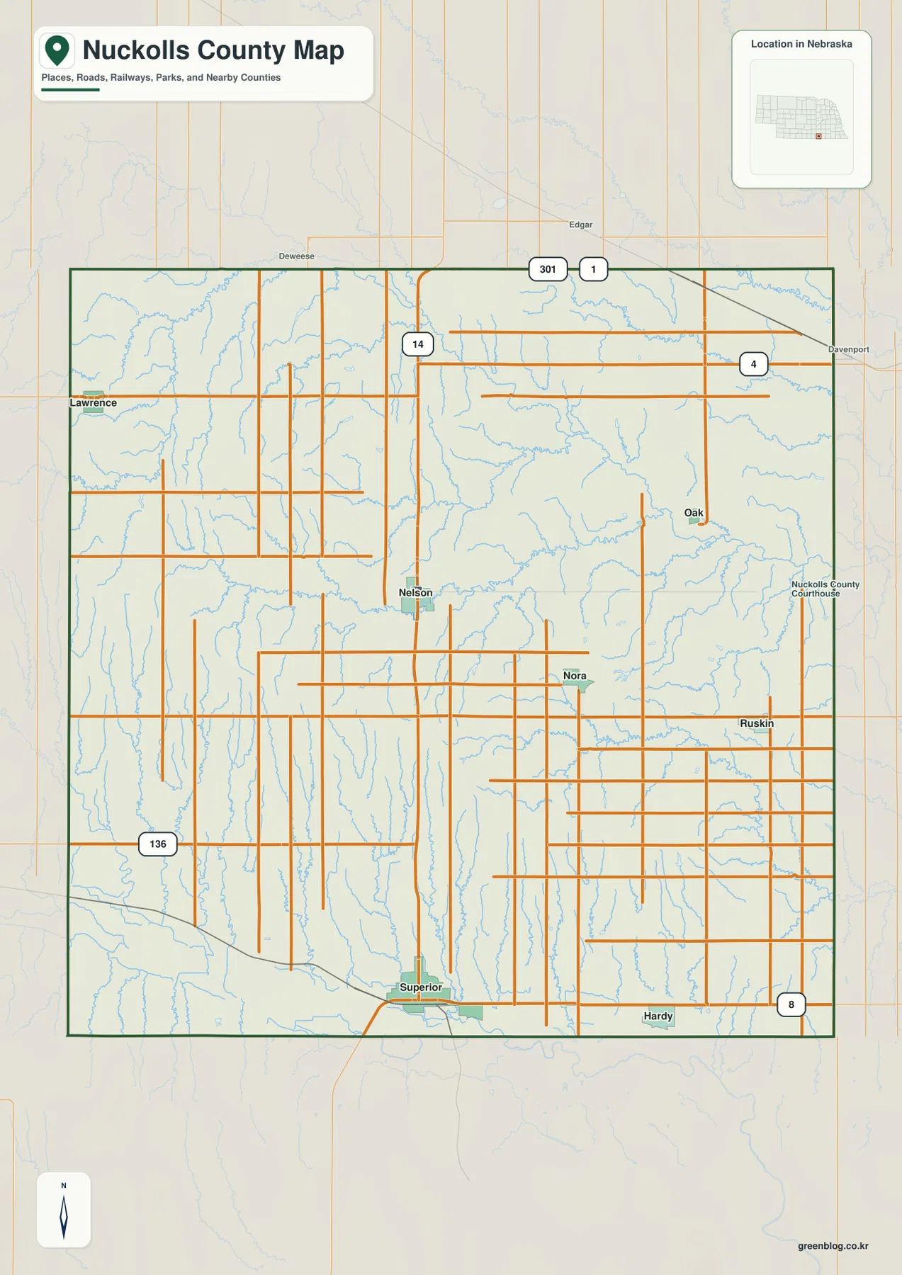
Lawrence is positioned close to the western boundary, while Oak and Ruskin sit well to the east. Hardy is farther south and close to the county edge. The map also labels nearby places outside Nuckolls County, including Deweese, Edgar, and Davenport. Those surrounding labels are useful because they show that a town close to the county line may relate geographically to places in the neighboring county as much as to a distant community within Nuckolls County itself.
This first map combines the most types of information: boundaries, roads, towns, rail lines or transport references where available, and many blue stream lines. It is therefore the most practical image for general orientation, but it should not be treated as a live traffic map, a parcel map, or a legal boundary survey. For current driving conditions, property questions, or legal jurisdiction, users should rely on the appropriate state, county, or navigation source rather than the visual overview on this page.
A settlement pattern led by Superior, with smaller towns spread widely
The city-index map strips away much of the road detail so that the relative positions of six principal communities are easier to compare. Superior is ranked first in the index, followed by Nelson, Lawrence, Ruskin, Hardy, and Oak. The numbers printed beside the names are best treated as reference values used when the map was prepared rather than as a substitute for current census estimates. For this article, the main value of the index is spatial: it shows where each community sits within the county and how far apart the principal settlement points are.
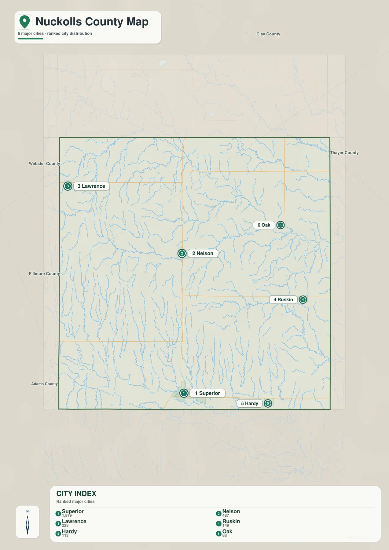
Superior stands apart because it is located directly along the southern side of the county. Nelson is much closer to the center, Lawrence lies near the western edge, and Oak and Ruskin occupy different positions in the east rather than forming one continuous cluster. Hardy is farther south than the other eastern communities. This distribution is useful when comparing travel direction, stream valleys, and terrain because each town represents a different part of the county rather than a single urbanized strip.
The city map also labels neighboring counties around the outside of the Nuckolls County outline, including Clay, Thayer, Webster, Fillmore, and Adams. Those labels give useful regional context. Lawrence is visibly close to the Webster County side, while Oak and Ruskin are nearer the eastern side toward Thayer County. The map does not define commuting areas or economic regions, but it does make clear why residents near a county boundary may have short geographic connections to places beyond Nuckolls County.
Historical records add another layer to the settlement pattern. Nuckolls County developed around river travel routes and later railroad connections, and individual towns did not all grow for the same reason. History Nebraska’s recent marker article about Oak notes that the original townsite grew around a gristmill and later shifted closer to a railroad. That history is a reminder that the present position of a small town on a map can reflect earlier changes in transportation as well as simple distance from the county seat.
Little Blue River, Elk Creek, and the branching stream network
The terrain-and-water map reveals a much more detailed drainage pattern than the general county map. The Little Blue River is the most prominent named channel across the northern half of the county. It enters from the northwest, bends across the north-central area, and continues eastward while collecting numerous smaller tributaries. Walnut Creek and Dry Creek approach this system from the west, and South Fork Big Sandy Creek appears farther east. Together, these channels define a broad river corridor that is easy to follow across the map.
South of the Little Blue River, Elk Creek runs for a long distance across the central part of the county. Oxbow Creek and Oak Creek are also labeled in this area, along with many unnamed tributaries. The shaded relief makes the relationship between water and landform especially clear: the blue lines sit within shallow to more deeply incised valleys rather than on a featureless plain. Around Oak, the drainage system provides a useful example of how a small settlement can sit near multiple creek valleys and a larger river corridor.
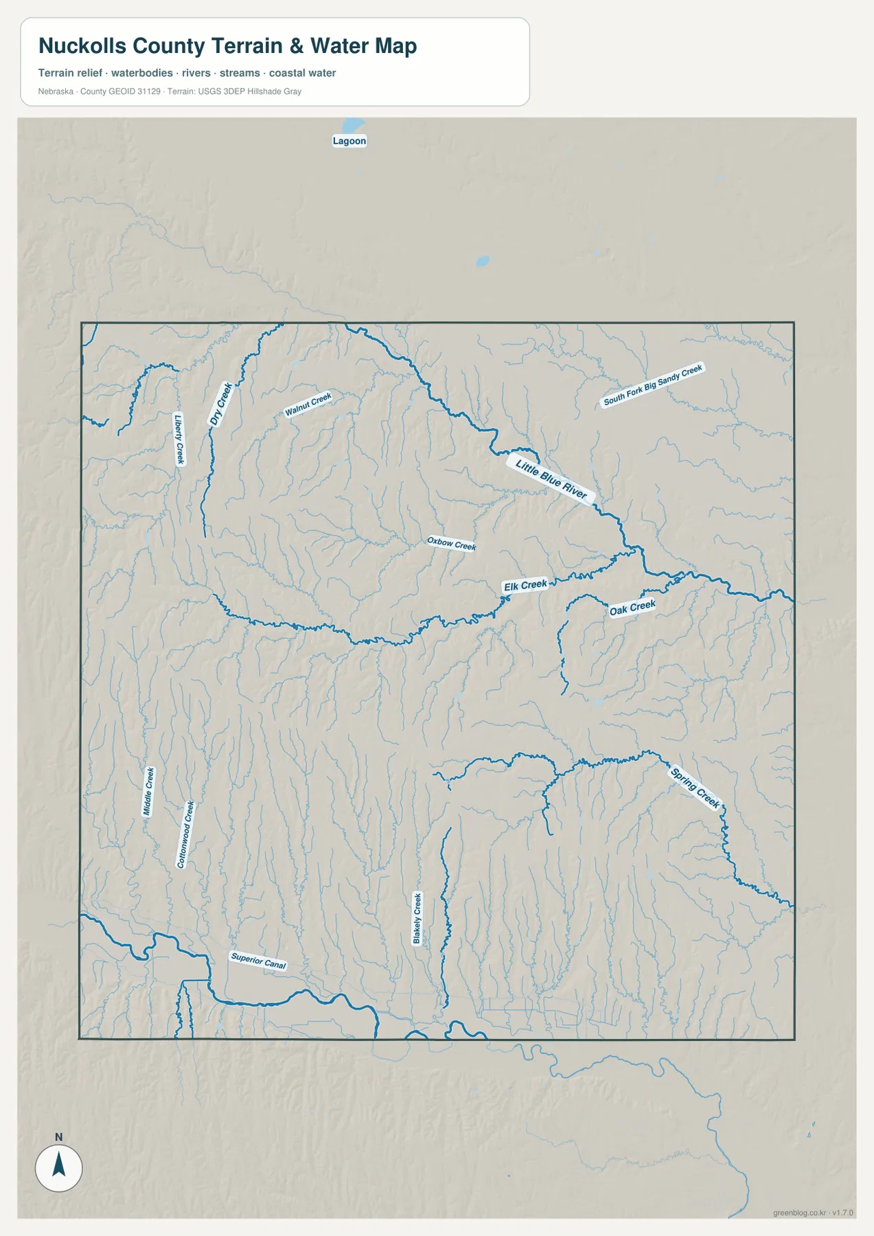
The southern half has a different visual pattern. Middle Creek and Cottonwood Creek extend generally toward the southern lowland, Blakely Creek is prominent in the south-central area, and Spring Creek curves through the southeast. The map also labels Superior Canal near the southwestern side. Rather than a single large named river dominating this part of the image, several north–south valleys descend toward the low terrain along the county’s southern edge. That contrast between the Little Blue corridor and the southern drainage is one of the strongest geographic features in the map set.
History Nebraska’s county archive notes that the Oregon Trail passed through Nuckolls County along the Little Blue River. This historical detail makes geographic sense when viewed beside the terrain map: the river creates a continuous valley through the northern part of the county. Older community material for Superior also identifies the Little Blue River and the Republican River Valley as major drainage settings in the county. These sources provide context for the map, but the current image is not intended to reconstruct historic trail alignments or show every river channel used in the past.
The water map is a reference for stream names, general locations, and terrain relationships. It is not a flood-hazard map, navigation chart, water-quality report, or legal access map. A blue line does not indicate a specific depth or year-round flow, and a wider-looking channel should not be interpreted as a measured discharge. Anyone making decisions about flooding, water resources, or stream conditions should consult current USGS and local agency information.
Higher western ground and lower river valleys toward the east and south
The elevation map shows a county with a noticeable west-to-east and upland-to-valley contrast. Its legend uses locally scaled terrain colors from about 476 to 572 meters, while the map notes an actual surface range of roughly 462 to 588 meters and a mean near 523 meters. Brown and tan dominate much of the west and southwest, indicating higher ground. Greener colors become more common toward the eastern side and along the major stream valleys, and a distinctly low green band follows the southern edge.
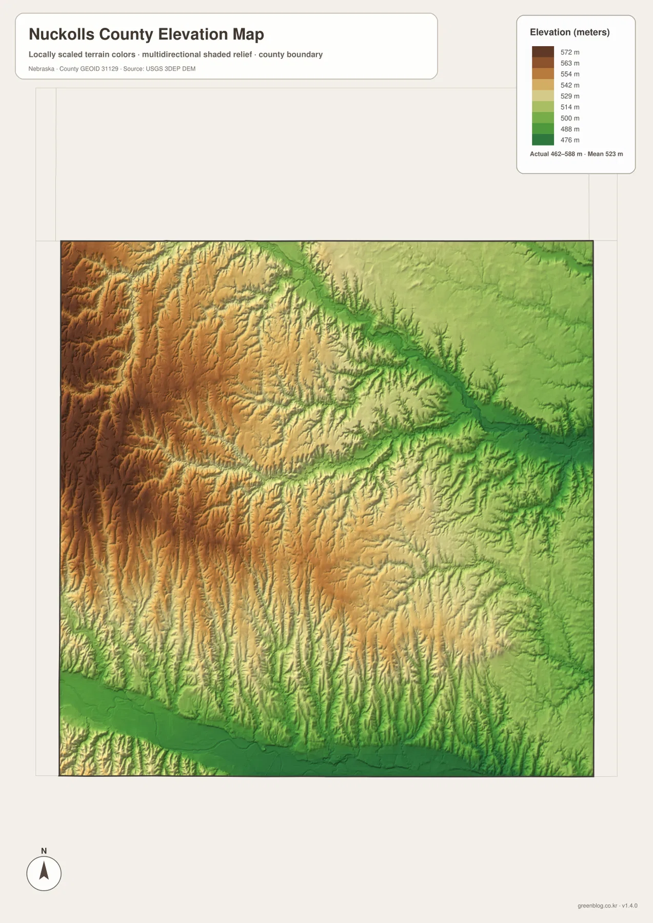
One of the easiest features to match between the water and elevation maps is the Little Blue River corridor. The river crosses a greener, lower band that curves from the northwest toward the east, while tributary valleys branch away into higher surrounding terrain. The west is not a single flat plateau; its surface is cut by many narrow drainage lines, producing a textured pattern of ridges and shallow valleys. This is why the elevation image looks more dissected in the west than a simple color gradient would suggest.
The southern side shows a similar connection between elevation and drainage. Near Superior and Hardy, the terrain along the county boundary is lower, and long valleys such as those associated with Middle Creek, Cottonwood Creek, Blakely Creek, and Spring Creek extend northward into higher land. If a reader imagines moving from Superior toward the interior of the county, the map suggests a gradual transition from a broad low setting into more rolling and incised terrain rather than an entirely level surface.
This elevation image is designed to communicate relative relief at county scale. It should not be used to determine a building pad elevation, a parcel corner, an engineered road grade, or a precise drainage design. Those tasks require survey-grade measurements or appropriate source elevation data. For education, trip planning, regional comparison, and understanding why rivers occupy certain corridors, however, the locally scaled elevation colors provide a clear visual summary.
Reading the Little Blue River and Oak with local history in mind
Nuckolls County is a good example of how a present-day geographic map can become more meaningful when paired with local history. History Nebraska records that the Oregon Trail followed the Little Blue River through the county, which helps explain why the river valley matters beyond hydrology. A separate History Nebraska marker article describes how the original townsite of Oak developed around a gristmill and later shifted closer to a railroad. Looking at Oak on the city map and then locating Oak Creek and the Little Blue River on the water map connects those historical references to an actual geographic setting.
That does not mean the maps on this page are historical-route maps. They do not trace the Oregon Trail in detail, identify abandoned railroad alignments, or reconstruct nineteenth-century town boundaries. Those topics require specialized historical sources. The value here is more basic: the maps show the valleys, towns, roads, and elevation differences that form the physical framework within which those historical events occurred.
Nelson and Superior also illustrate two different ways a settlement can matter within the same county. Nelson is the county seat and sits in an inland, relatively central location. Superior is the most prominent settlement in the city index and lies in the low southern part of the county. Comparing them across all four maps gives more information than a simple distance measurement because the road network, drainage, and elevation change are visible at the same time.
Choosing the right Nuckolls County map for a specific task
Use the general county map when boundaries, towns, roads, and a broad sense of the stream network need to appear together. Choose the city-index map when the main question is where Superior, Nelson, Lawrence, Ruskin, Hardy, and Oak sit relative to one another. The terrain-and-water map is better for locating the Little Blue River, Elk Creek, Oak Creek, Oxbow Creek, and the many tributary valleys. The elevation map is the clearest choice for explaining the higher west, the lower Little Blue corridor, and the low terrain along the southern boundary.
When comparing more than one map, Nelson or Superior can serve as a common anchor. Starting with Nelson, a reader can locate Highway 14 on the county map, confirm Nelson’s central position on the city map, then move to the water and elevation maps to see how the surrounding stream valleys fit into the terrain. Starting with Superior makes it easier to compare the southern road network, Superior Canal, nearby drainage lines, and the low green elevation band along the border.
For a printed handout or presentation, it is usually clearer to select the map that matches the question instead of shrinking all available information into one image. The JPG originals are substantially larger than the WebP previews and preserve labels more clearly when printed or displayed on a large screen. Higher image resolution does not turn them into parcel, survey, engineering, or flood-control products, so specialized decisions still require the appropriate official source.
Frequently Asked Questions
Which map is best for following the Little Blue River across Nuckolls County?
The terrain-and-water map is the best choice because it labels the Little Blue River and several connected tributaries, including Walnut Creek, Dry Creek, and South Fork Big Sandy Creek. Pairing it with the elevation map adds useful context because the river follows a lower green corridor through the northern half of the county, with tributary valleys cutting into higher surrounding terrain.
What is the easiest map for comparing Superior and Nelson with the road network?
The general county map is the most useful because it shows both towns together with major highways and local roads. Nelson is close to Highway 14 in the interior, while Superior is near the southern boundary. The city-index map can then be used for a simpler comparison of settlement positions, and the water or elevation map can add terrain context if needed.
Can the elevation map be used for land surveying or construction design?
No. The elevation map is a county-scale visualization intended to show relative differences such as higher western ground and lower river valleys. It does not provide survey-grade elevations, parcel boundaries, engineered slopes, or site-specific drainage measurements. Professional work should use the appropriate USGS source data, local records, and field surveying.
Map File Information
Download the four high-resolution JPG maps shown on this page for Nuckolls County in one ZIP archive.
- Included Files: Use only the versions confirmed in the article and supplied images
- File Type: Use the confirmed download contents
- Intended Use: Printing, education, presentations, and map-based projects
Related Maps
Sources and references
Local historical context for the county organization, Nelson, and the Little Blue River corridor comes from History Nebraska. The Oak townsite article provides a county-specific example of settlement change, while the national data links below are useful references for the boundary, hydrography, and elevation information represented in the map set.
- Nuckolls County official website
- History Nebraska – Nuckolls County archival record and historical note
- History Nebraska – Original Townsite of Oak
- U.S. Census Bureau – TIGER/Line Shapefiles
- USGS – National Hydrography
- USGS – 3D Elevation Program
Green Map creates custom-edited map images using open geographic data sources such as geoBoundaries, Natural Earth, OpenStreetMap, and government open data. These maps are edited visual materials, not raw data files, and are provided for education, documents, presentations, and graphic reference.