Morrill County is easiest to understand when the North Platte River is used as the main geographic reference. The river cuts across the central part of the county, and the best-known communities—Bayard, Bridgeport, and Broadwater—sit close to that lower corridor rather than in the rougher uplands near the outer edges. This Morrill County Map page brings together the county boundary, roads, town locations, waterways, and elevation in separate views. The same map set can also be downloaded as high-resolution A3 JPG files, making the page useful both for quick on-screen orientation and for printing. High-resolution map files are available for download in the section below.
Bridgeport provides a convenient starting point because it lies near the center of the county, close to the river, and serves as the county seat. Bayard is west of Bridgeport, while Broadwater is farther east along the valley. Once those three places are located, the rest of the geography becomes much easier to follow: U.S. 26 tracks the broad river corridor, tributary creeks descend from higher ground, and the elevation map shows a pronounced low belt through the middle of the county. The four supplied maps emphasize different parts of that same landscape rather than unrelated features.
Table of Contents
Start with Bridgeport and the county boundary
The county overview is the best place to establish orientation. It outlines Morrill County in a dark boundary and places roads, rail lines, communities, and streams within the same frame. Bridgeport stands near the middle of the map where several transportation lines converge close to the North Platte River. U.S. 26 follows the valley eastward, U.S. 385 approaches the Bridgeport area from the south, and Nebraska 92 is useful for locating Bayard and the western side of the county. Smaller numbered roads branch away from the main corridor and show how travel spreads toward the northern and southern uplands.
The background outside the county line adds useful regional context without overwhelming the map. Alliance appears north of the county, while places such as Dalton and Gurley appear beyond the southern side. The map also hints at the neighboring county network and shows that the roads and river corridor continue beyond the Morrill County boundary. This matters because the county is not an isolated block: its principal east–west route is part of a larger western Nebraska travel corridor, and the surrounding roads connect local communities with the rest of the Panhandle.
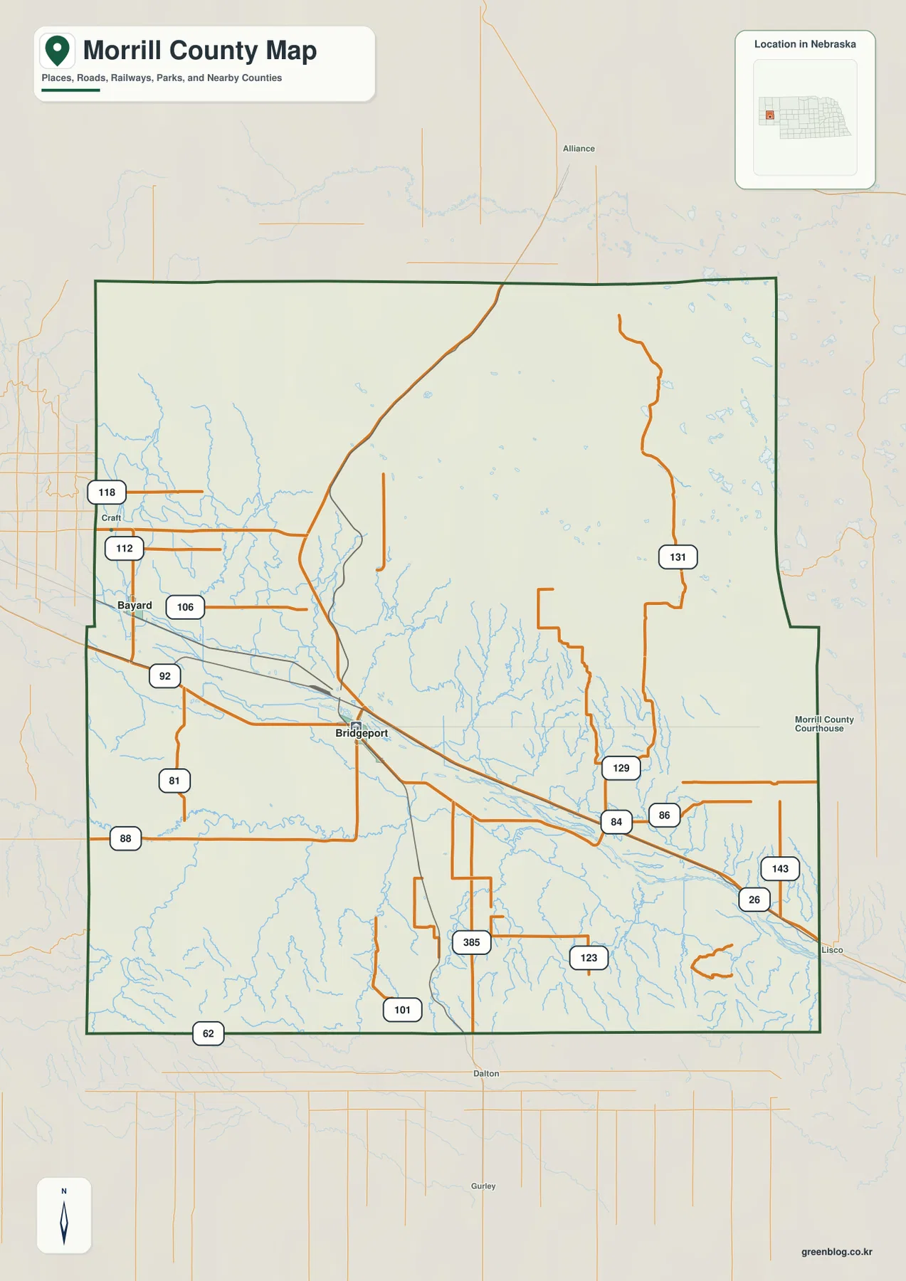
For practical use, this map works well as a reference sheet rather than a navigation product. It lets a reader see whether a place lies north or south of the river, where a major road leaves the county, and how Bridgeport relates to Bayard and the eastern valley. It does not show current closures, construction, speed restrictions, or turn-by-turn directions, so a live road source is still necessary for driving. Its strength is geographic context: one glance is enough to establish the county’s central corridor before moving to the more specialized town, water, and elevation maps.
Why Bayard, Bridgeport, and Broadwater line up with the valley
The city-connections map strips away much of the road detail and reduces the county to a simpler relationship among three communities. Bayard is the hub point, Bridgeport is shown about 13 miles away, and Broadwater about 27 miles away. Those measurements are straight-line distances, not road mileage, so they should be used only to compare spacing. What the simplified map reveals especially well is the west-to-east sequence of the towns: all three occupy the broad central zone associated with the North Platte valley rather than being scattered across the higher northern and southern terrain.
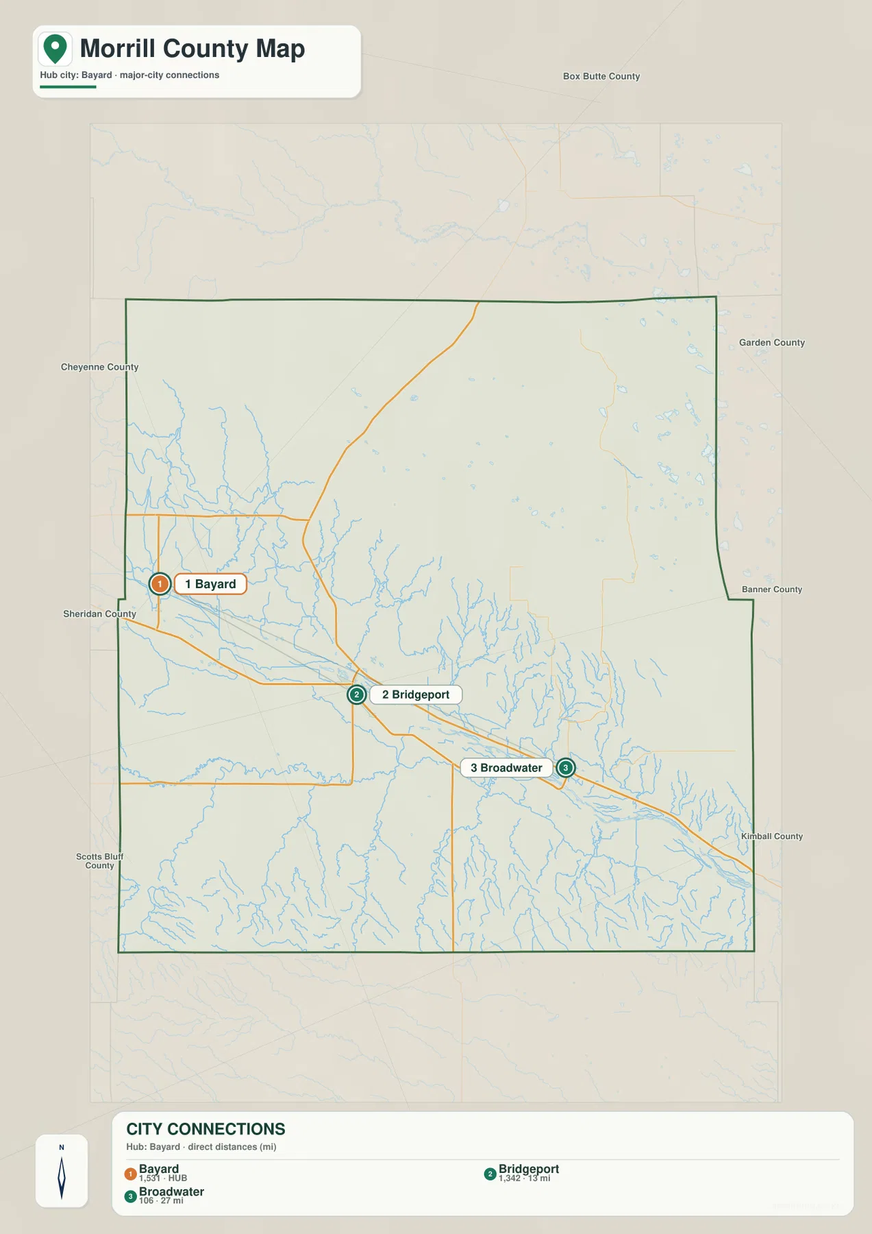
This simplified view becomes more useful when it is compared with the other maps rather than treated as a standalone mileage chart. Move from Bayard to Bridgeport and then to Broadwater, and the water map shows that the sequence stays close to the North Platte corridor. The elevation map places the same towns in the lower green belt that runs through the county. The match is not exact at every point, but the broad pattern is clear: settlement and transportation are concentrated in the easier central passage while more broken terrain occupies much of the land to the north and south.
Bayard also provides a useful connection to Morrill County’s historic landscape. Chimney Rock State Historic Site lies south of Bayard near Nebraska 92 and is one of the best-known landmarks associated with nineteenth-century travel through the North Platte Valley. History Nebraska identifies it with the Oregon, California, and Mormon Trails. The supplied maps are not historic-trail maps, but adding that context helps explain why this valley has long been a recognizable travel corridor. Courthouse and Jail Rocks south of Bridgeport provide another example of the striking landforms that rise above the lower valley floor.
Creeks, lakes, and the drainage around the North Platte River
The terrain-and-water map gives the river system much more prominence than the county overview. The North Platte River is the dominant waterway, entering from the west and crossing the lower middle of Morrill County before continuing toward the southeast. Numerous smaller channels descend toward it from both sides. Red Willow Creek is labeled in the northwest, while Pumpkin Creek approaches from the southwest. South of the river, Middle Creek, Greenwood Creek, and Deep Holes Creek cut through the uplands, showing how strongly the surrounding terrain is divided by smaller valleys.
A different water pattern appears in the northeastern part of the county. Several small named lakes are grouped there, including Mc Carthy Lake, Ryan Lake, Smith Lake, Rush Lake, Storm Lake, and Goose Lake. They are separated from the main river corridor and give the northeast a distinct appearance on the map. Comparing that lake cluster with the dense tributary network around the central and southern areas is a useful reminder that water features within one county can take very different forms. The map shows location and terrain context, not seasonal water levels or public access conditions.
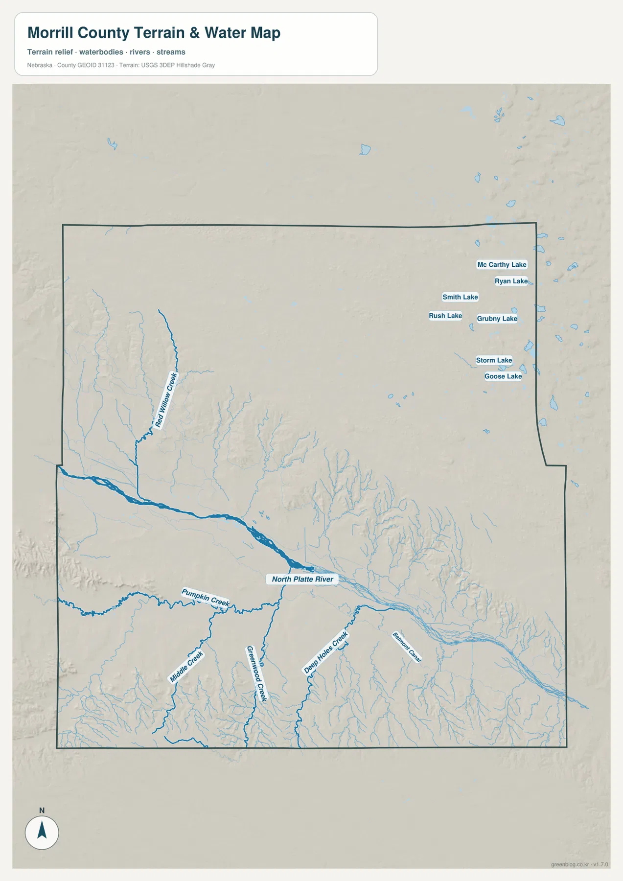
Reading the drainage together with the town map adds physical context to the settlement pattern. Bayard, Bridgeport, and Broadwater remain close to the broad central valley, while narrower tributaries cut through the more uneven country away from the river. The water map is useful for classroom geography, local orientation, and comparing named streams, but it should not be treated as a flood-hazard map, parcel map, legal water-rights document, or navigation chart. Those questions require current authoritative products designed specifically for flood risk, ownership, regulation, or field navigation.
Elevation makes the central lowland unmistakable
The elevation map turns the county’s relief into a clear visual contrast. Darker greens occupy the North Platte valley, while lighter greens, tans, and browns increase toward the northwest, north, and southern edge. The legend uses local color bands from about 1,087 to 1,354 meters and notes an actual countywide range of roughly 1,061 to 1,403 meters, with a mean near 1,219 meters. The exact values are useful for context, but the more important message is the shape of the terrain: a broad lower corridor cuts through the middle between higher ground on both sides.
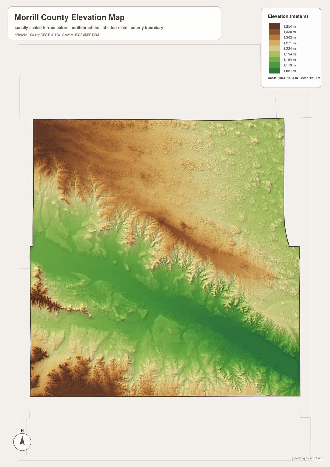
The northwestern part of the map shows pronounced ridges and incised valleys, while the southern side also contains deeply cut terrain. By comparison, the belt around Bayard, Bridgeport, and Broadwater is broader and lower. That contrast helps explain why the major transportation and settlement corridor follows the valley. It also connects naturally with the water map: many tributaries begin in higher terrain and descend toward the main river. A reader can therefore move from town locations to waterways and then to elevation without needing specialized GIS software to understand the county’s basic physical structure.
The elevation surface is intentionally generalized. It is appropriate for comparing high and low areas across the county, but it is not precise enough for surveying, construction design, drainage engineering, parcel work, or determining an exact elevation at a specific site. For those purposes, project-specific survey information or authoritative elevation data such as USGS 3D Elevation Program products should be consulted. On this page, the map is best used to explain why the North Platte corridor looks and functions differently from the rougher uplands around it.
Choose the map according to the question you need to answer
Use the county overview when the main question involves boundaries, roads, communities, or general orientation. The city-connections map is better when you want a quick comparison of where Bayard, Bridgeport, and Broadwater sit relative to one another. For rivers, creeks, lakes, and the shape of drainage valleys, the terrain-and-water map carries the most detail. The elevation map adds the clearest view of the low central corridor and higher outer terrain. Switching between these views is more informative than trying to force every detail into a single image.
For printed handouts, reports, presentations, or school projects, use the downloadable A3 JPG originals rather than relying on the smaller web previews. The ZIP contains four high-resolution files matching the maps on this page: county overview, city connections, terrain and water, and elevation. If several are placed side by side, keeping the north arrow and county boundary in the same orientation makes it easier to trace a town, stream, or ridge from one image to the next. These maps are intended for geographic explanation and reference, not for legal boundary decisions or precision measurement.
Frequently Asked Questions
Why is Bridgeport a useful starting point on the Morrill County maps?
Bridgeport lies near the middle of Morrill County, close to the North Platte River, and serves as the county seat. Several mapped roads meet in the area, so it works well as an anchor for finding Bayard to the west and Broadwater to the east. Once Bridgeport is located, the relationship among the river corridor, towns, and major roads becomes much easier to follow across all four maps.
Are the 13-mile and 27-mile figures on the city map driving distances?
No. They are straight-line distances measured from Bayard to Bridgeport and Broadwater. Actual road travel follows the transportation network and may be longer. The figures are included to show relative spacing within the county, not to replace a route planner or current navigation service.
What can I learn by comparing the water and elevation maps?
The pair shows how tributary valleys descend from higher ground toward the lower North Platte corridor. The water map identifies the river, named creeks, and northeastern lakes, while the elevation map shows the broad low belt and the higher terrain around it. Together they provide a clear countywide picture of terrain and drainage, but they are not substitutes for flood studies, engineering surveys, or legal property records.
Map File Information
The Morrill County map set is packaged as four high-resolution A3 JPG originals for printing, classroom use, presentations, and general geographic reference.
- Included Files: Use only the versions confirmed in the article and supplied images
- File Type: Use the confirmed download contents
- Intended Use: Printing, education, presentations, and map-based projects
Related Maps
Sources and references
The county description is supported by official local information, Nebraska historical resources, and public U.S. geographic datasets. The following links provide county context, information on Chimney Rock, and authoritative sources for boundary, hydrography, and elevation data.
- Morrill County Nebraska official website
- History Nebraska – Chimney Rock State Historic Site
- U.S. Census Bureau – TIGER/Line Shapefiles
- USGS – National Hydrography
- USGS – 3D Elevation Program
Green Map creates custom-edited map images using open geographic data sources such as geoBoundaries, Natural Earth, OpenStreetMap, and government open data. These maps are edited visual materials, not raw data files, and are provided for education, documents, presentations, and graphic reference.