Greeley County spans a varied piece of central Nebraska between the North Loup River on the southwest and Cedar River country in the northeast. Scotia, Greeley Center, Spalding, and Wolbach are separated by creek-cut uplands rather than a single continuous settlement corridor. The western and northwestern hills are the highest parts of the county, while the two river valleys and the long Spring Creek system create broad lower routes through the landscape.
This page explains the four ranked communities, the straight-line distances measured from Scotia, Highways 22, 56 and 91, U.S. 281, North Loup River, Cedar River, Spring Creek and its branches, and an elevation range of about 557 to 720 meters. The original high-resolution JPG map files can also be downloaded together in a ZIP when larger labels or printable copies are needed.
Table of Contents
Greeley Center sits near the middle of the county’s road network
Greeley is the county seat, although the supplied maps use the historical and railroad-era label Greeley Center. The official county website lists Greeley, Spalding, Scotia, and Wolbach as the county’s four villages. Greeley Center’s near-central location makes it the easiest reference point for understanding how those communities are arranged.
Scotia occupies the southwest near the North Loup River, Spalding lies far to the northeast near Cedar River drainage, and Wolbach sits close to the southern edge on the eastern side. The towns therefore occupy different river and creek settings rather than one single valley or highway strip.
The Nebraska Association of County Officials says Greeley County was authorized in 1871, organized in 1872, and named for journalist and political figure Horace Greeley. Its history describes the county as lying between Cedar River to the northeast and North Loup River to the southwest, the same two low corridors that stand out on the supplied terrain maps.
Highway 22 links Scotia with the center while U.S. 281 angles southeast
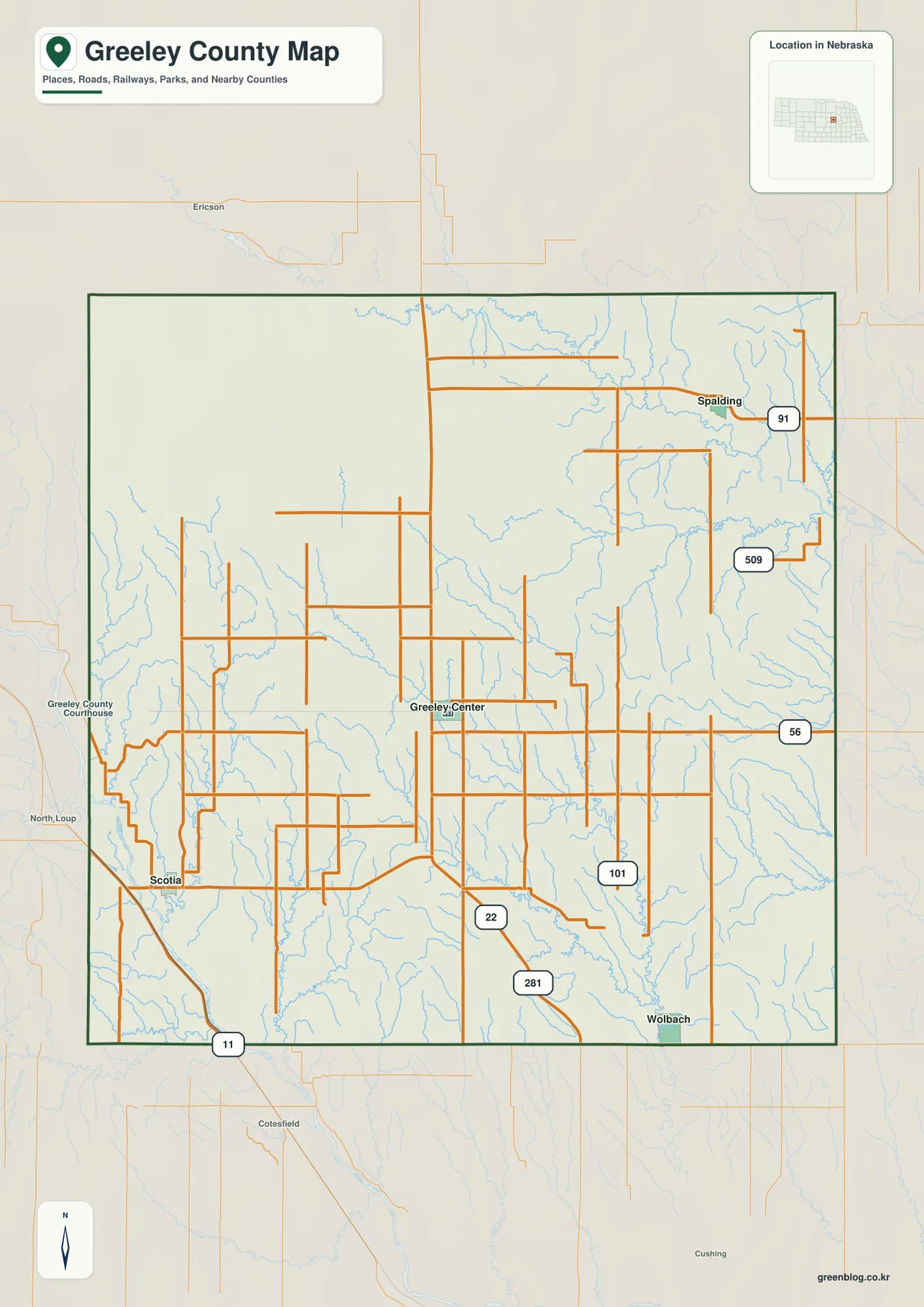
Highway 22 provides the most obvious road connection from Scotia toward Greeley Center. Highway 56 extends eastward from the central part of the county, while U.S. 281 angles southeast toward the county boundary. Together these routes give the southern and central half of the map a clear framework.
Highway 91 crosses the Spalding area in the northeast, and routes 101 and 509 appear across the eastern interior. Highway 11 leaves Scotia toward the southwest. Between these numbered roads is a dense network of county routes that serves farms and ranches across the uplands.
The road network becomes less regular where creek valleys cut into the hills. Routes across the western and central uplands often bend around drainage lines, while roads and settlements are more concentrated in the North Loup and Cedar river lowlands. Current construction, closures, road surfaces, and travel times should be checked with live Nebraska transportation information.
Scotia is 11 miles from Greeley Center, 17 from Wolbach, and 23 from Spalding in straight-line distance
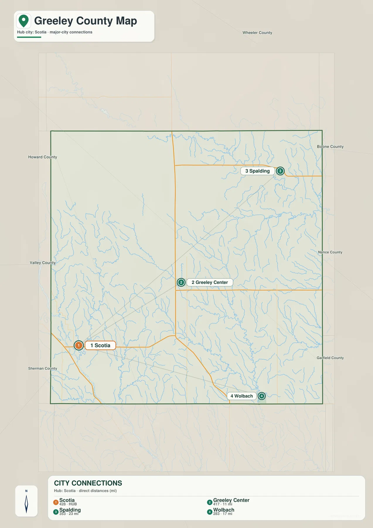
The city distribution map uses Scotia as its hub. It prints direct distances of 11 miles to Greeley Center, 17 miles to Wolbach, and 23 miles to Spalding. These are straight-line measurements between the mapped places, not road mileage, so actual driving routes will generally be longer.
The geometry is useful even without a road calculation. Greeley Center lies relatively close to Scotia toward the northeast, Wolbach is farther southeast, and Spalding is the most distant of the three in the far northeast. Comparing the city view with the highway map makes the county’s dispersed settlement pattern much easier to understand.
The values printed in the ranking are 428 for Scotia, 417 for Greeley Center, 353 for Spalding, and 283 for Wolbach. They belong to the supplied city graphic and should not be treated as a continuously updated population table. Current official population figures should be checked with the U.S. Census Bureau or Greeley County sources.
Spring Creek crosses the uplands between the North Loup and Cedar river valleys
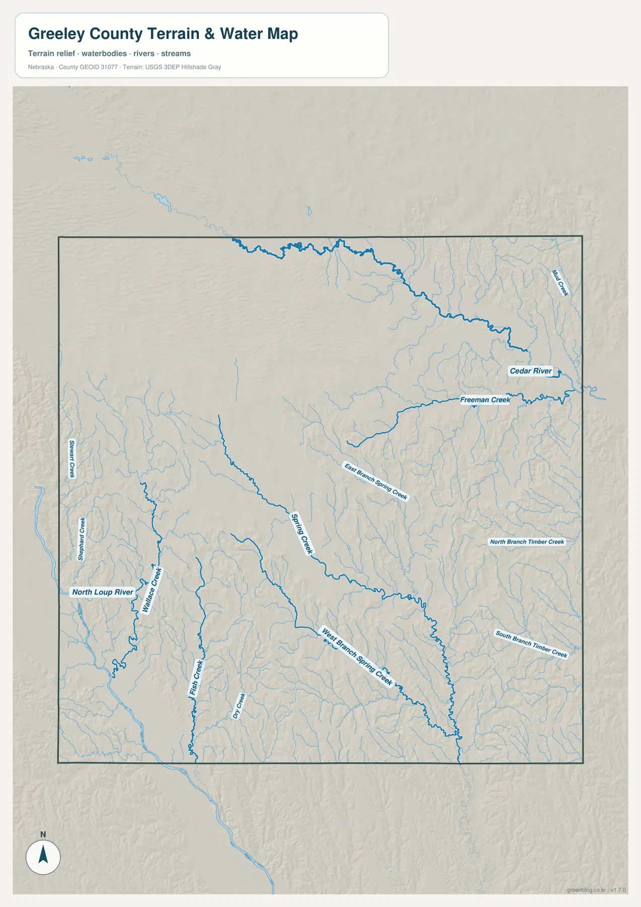
North Loup River is the dominant water feature on the southwestern side near Scotia. Willow Creek and Fish Creek descend toward this low corridor from the interior, while Stewart Creek appears along the western side. These valleys break the western high ground into a series of long ridges and narrow bottoms.
Spring Creek is the major interior drainage. It runs across the central county toward the southeast and receives both East Branch Spring Creek and West Branch Spring Creek. On the elevation map, the system forms a long green corridor through terrain that is otherwise higher and more strongly ridged.
Cedar River is the major northeastern feature, with Freeman Creek joining the same general drainage country. North Branch Timber Creek and South Branch Timber Creek appear farther south on the eastern side. Greeley County’s official website highlights Cedar River as a local canoeing and fishing resource, giving the northeast valley both geographic and recreational importance.
This water map is intended for geographic reference. It does not define flood zones, legal water rights, parcel boundaries, present streamflow, depth, navigability, or public access. Those questions require current information from USGS and the responsible local or state agencies.
Western uplands stand about 163 meters above the lowest river country
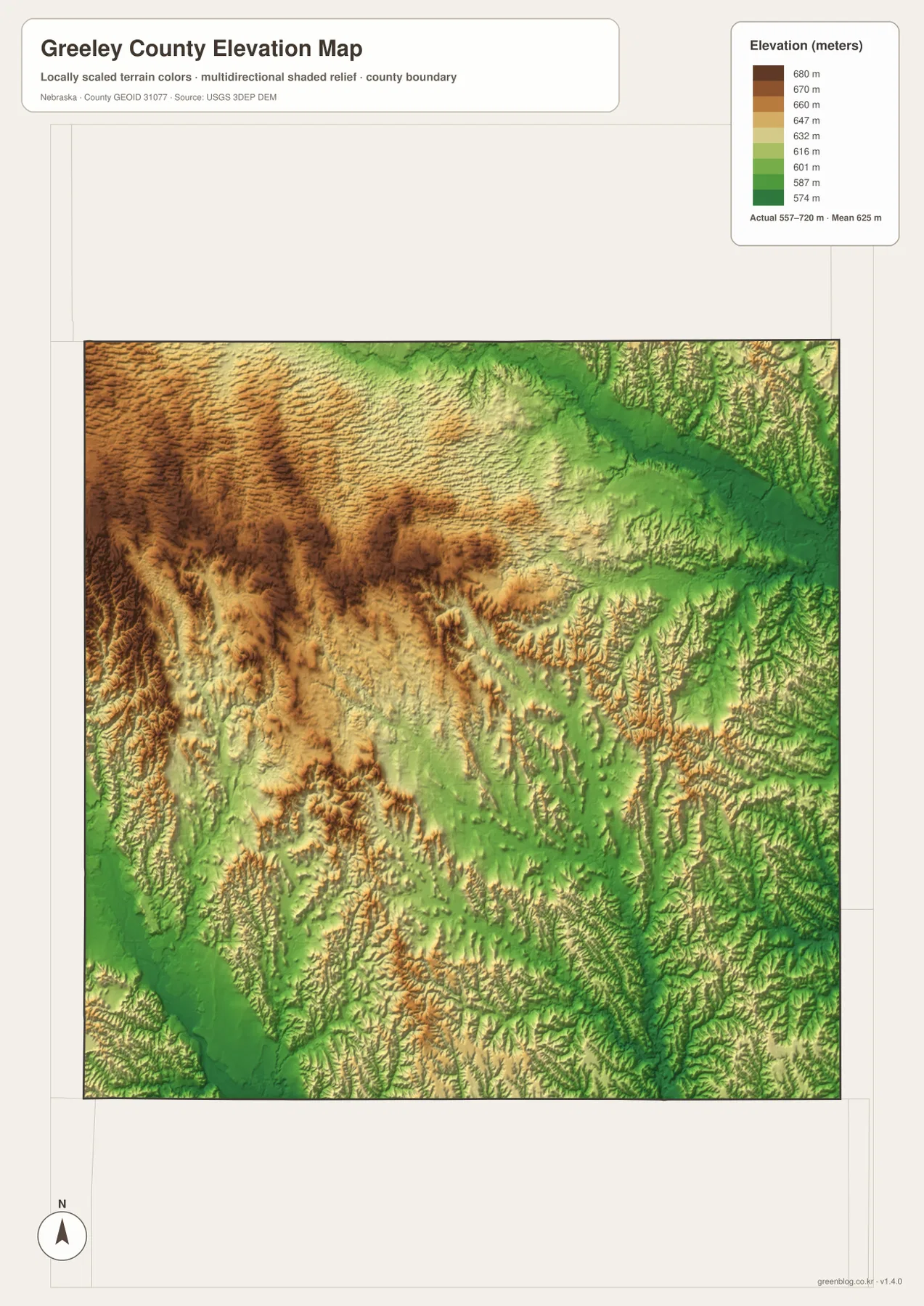
The elevation map reports an actual county-wide range of approximately 557 to 720 meters, with a mean near 625 meters. The highest brown terrain occupies much of the west and northwest, while the darkest green lowlands follow North Loup River in the southwest and Cedar River in the northeast. Total mapped relief is about 163 meters.
The western uplands are not a smooth plateau. Repeated ridges and small valleys give the surface a deeply textured appearance, and Willow Creek and Fish Creek cut downhill toward the North Loup. Across the middle of the county, Spring Creek and its branches create another obvious low pathway.
Near Cedar River, a broad green valley occupies the northeast, but higher ridges quickly return to the south and west. Freeman Creek and the Timber Creek branches subdivide those eastern uplands further. This combination explains why the county looks hilly even though it has no mountain range.
The elevation colors are scaled locally for Greeley County and should be used only for comparisons within this map. Similar colors on another county map may represent different absolute heights. The generalized surface is not survey-grade information for engineering, construction, drainage design, or property work.
Railroad growth moved the county seat from Scotia to Greeley Center
The Nebraska Association of County Officials says Scotia became the county seat after defeating Lamartine in 1874, and a courthouse followed in 1875. Scotia’s location near North Loup River made it an important early settlement, but residents in the growing northern and eastern parts of the county faced long trips to reach county government.
Greeley Center changed that balance after railroad development reached the centrally located town in 1885. The new community built a courthouse before it had actually secured the county seat, and after several elections it finally won the designation from Scotia in 1890. The village later shortened its official name to Greeley, although Greeley Center remains common on maps and in historical references.
Irish Catholic settlement left a distinctive mark on Spalding and nearby communities
One of Greeley County’s most distinctive historical themes is the Irish Catholic Colonization Association. Nebraska county history says the organization purchased tens of thousands of acres to help Irish immigrants move from eastern cities to farms in Nebraska. Spalding, Belfast, and O’Connor all carry strong connections to that colonization effort.
Spalding remains a village in the northeastern part of the county near Cedar River drainage and Highway 91. O’Connor no longer appears as one of the ranked cities on the supplied map, but it was historically important as a Catholic colony. The modern Greeley Irish Festival, promoted by the county’s official website, shows that the immigrant story remains part of the county’s present-day identity.
Use Scotia and Greeley Center as the simplest orientation pair
For basic orientation, start at Scotia and follow Highway 22 toward Greeley Center. From there, extend the map northeast toward Spalding and southeast toward Wolbach. The straight-line distances of 11, 17, and 23 miles provide a quick sense of scale before road mileage is considered.
For physical geography, use North Loup River in the southwest and Cedar River in the northeast as opposite anchors. Spring Creek and its branches cross the higher interior between them, while the elevation map shows high brown uplands dropping into green river and creek valleys.
The downloadable high-resolution JPG files are useful when small county-road labels or tributary names are difficult to read in the web previews. Starting with the Scotia-Greeley Center relationship and then comparing the two river valleys with the elevation surface gives a clear overview of Greeley County.
Frequently Asked Questions
Are the distances from Scotia road distances?
No. The map labels 11 miles to Greeley Center, 17 miles to Wolbach, and 23 miles to Spalding as straight-line distances from Scotia. Actual driving routes are longer and depend on the roads selected.
Are Greeley Center and Greeley the same place?
Yes. The supplied map uses Greeley Center, while the current county website generally uses Greeley for the county-seat village. The settlement developed as a centrally located railroad town and later shortened its official name.
Where is the lowest terrain in Greeley County?
The broadest low areas follow North Loup River in the southwest and Cedar River in the northeast. The mapped elevation range is about 557 to 720 meters, with the western and northwestern uplands standing highest and the major creek valleys locally lower.
Map File Information
The ZIP contains the original high-resolution JPG files for the Greeley County boundary and road map, city distribution map, terrain and water map, and elevation map.
- Included Files: Use only the versions confirmed in the article and supplied images
- File Type: Use the confirmed download contents
- Intended Use: Printing, education, presentations, and map-based projects
Related Maps
Sources and references
- Greeley County – About Our County
- Nebraska Association of County Officials – Greeley County
- Village of Spalding – Official Website
- U.S. Census Bureau TIGER/Line Shapefiles
- USGS National Hydrography
- USGS 3D Elevation Program
These maps are intended for geographic reference. For legal boundaries, land ownership, flood determinations, water rights, road conditions, construction, surveying, or other decisions requiring current authoritative information, consult Greeley County and the responsible state or federal agency.
Green Map creates custom-edited map images using open geographic data sources such as geoBoundaries, Natural Earth, OpenStreetMap, and government open data. These maps are edited visual materials, not raw data files, and are provided for education, documents, presentations, and graphic reference.