Teton County occupies a striking piece of north-central Montana where the Rocky Mountain Front rises abruptly along the west and broad plains stretch away to the east. Choteau is the county seat and the easiest place to use as an orientation point, while Bynum and Pendroy lie to the north, Fairfield sits to the southeast, and Dutton is farther east near Interstate 15. The maps on this page separate roads and settlements, city-to-city spacing, water features, and elevation so each part of the county is easier to understand. Original high-resolution JPG files can be downloaded below for printing, classroom use, reports, or general regional reference. High-resolution map files are available for download in the section below.
The county changes character quickly from west to east. Around Choteau, U.S. 89 and U.S. 287 provide clear road references, and the eastern side is tied to the Interstate 15 corridor near Dutton. Farther west, the road pattern becomes less important than the mountain valleys, ridges, and streams descending from the front. The Teton River system crosses that transition, linking high western headwaters with lower country across the center and east. Looking at the four supplied maps together makes it easier to see why towns, roads, waterways, and terrain do not all follow the same pattern.
Table of Contents
Start with Choteau to place the roads and communities
On the county map, Choteau sits slightly west of center and works as the most practical anchor for reading the rest of Teton County. U.S. 89 runs north toward Bynum and Pendroy, while U.S. 287 approaches from the southwest and meets the road network at Choteau. Fairfield is southeast of the county seat, and Dutton is separated farther to the east, where Interstate 15 runs north-south. The map also labels smaller places such as Rockport Colony, Miller Colony, and New Rockport Colony, giving a better sense of how settlement is spread over a large rural area rather than concentrated in one continuous built-up zone.
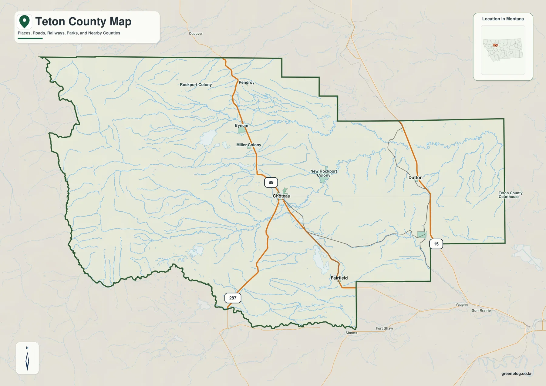
The outline also hints at the county’s physical geography. The western boundary is irregular where the county reaches into the Rocky Mountain Front, while the central and eastern sections open into broad lower terrain. Communities and major roads are easier to pick out east of the most rugged mountain belt. For a first-time visitor, this is the best map for answering basic questions such as which side of the county a town is on, which major highway is nearby, or how Choteau relates to Fairfield and Dutton. It is a regional reference map rather than a turn-by-turn navigation product, so current road information should still be used for actual driving decisions.
The elevation change is concentrated along the western edge
The elevation map makes the county’s strongest geographic contrast immediately visible. High terrain is packed into the west along the Rocky Mountain Front, shown with brown and tan colors and tightly defined ridges and valleys. Moving east from that mountain belt, the surface drops rapidly into greener, gentler terrain across the center of the county and continues lower toward the eastern plains. Choteau and the other main communities are outside the highest mountain interior, which helps explain why the settlement and highway pattern on the county map is weighted toward the lower country rather than the rugged western edge.
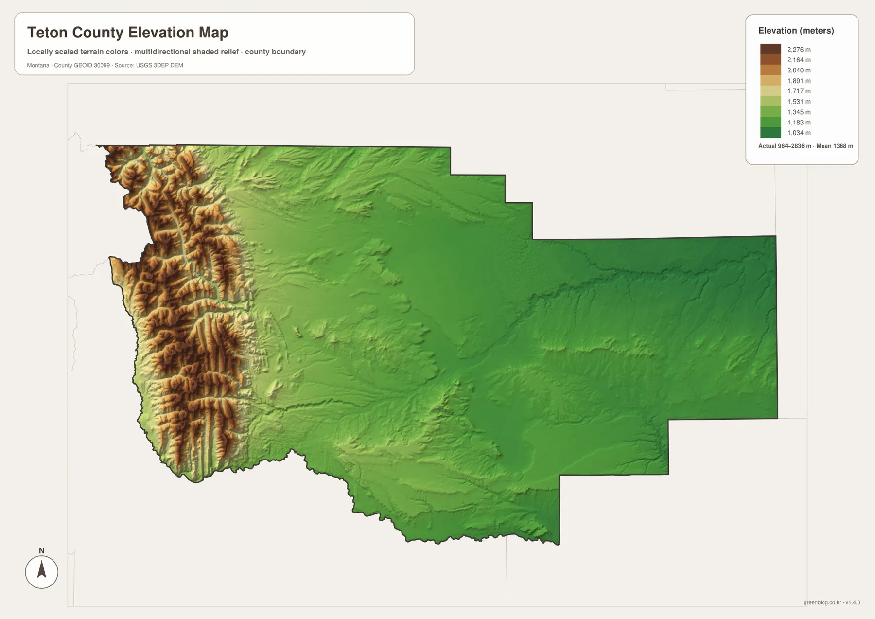
The legend reports an actual elevation range of roughly 964 to 2,836 meters across the mapped county. That wide span is useful for understanding regional relief, but the generalized surface is not a survey or engineering measurement for a particular property. What matters most at this scale is the pattern: the western strip rises sharply, the foothill zone steps down toward Choteau, and the eastern half is much less rugged. In a classroom or report, pairing this map with the roads-and-communities map helps explain why the most direct visual boundary in Teton County is not a highway or river but the sudden transition from mountain front to open plains.
The Teton River system carries mountain water toward the plains
The terrain-and-water map shifts attention from roads to drainage. The North Fork Teton River and South Fork Teton River descend from the western high country, and the Teton River continues across the county toward the east. Muddy Creek appears farther north, Deep Creek crosses the south-central area, and the North Fork Sun River and Sun River are visible near the southwestern and southern edge. The dense network of smaller streams in the western half follows the mountain and foothill terrain, while the lower eastern country shows a different, more open pattern. This makes the water map especially useful for connecting the rugged west with the agricultural and settled plains farther east.
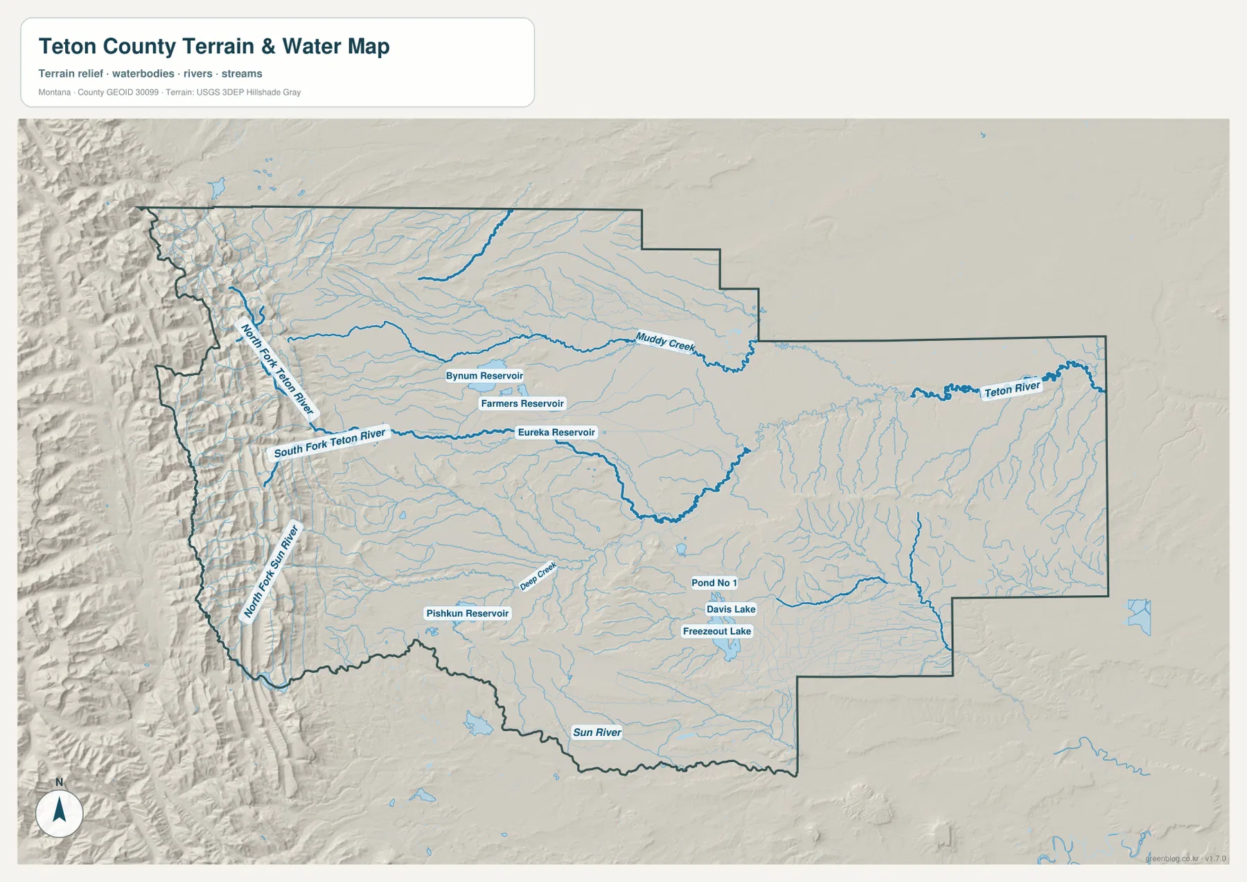
Several named reservoirs and lakes provide useful landmarks away from the main river channels. Bynum Reservoir, Farmers Reservoir, and Eureka Reservoir appear in the north-central to northwestern part of the county, while Pishkun Reservoir lies farther southwest. Davis Lake and Freezeout Lake are shown farther to the southeast. Teton County’s growth-policy material describes the long importance of agriculture and irrigation in the area, which gives useful background for why water is such a prominent part of the local landscape. Even so, this map should be read only as a regional water-and-terrain reference; it does not establish flood risk, water depth, navigability, parcel limits, or legal water boundaries.
The connection map simplifies Choteau, Fairfield, and Dutton
The city-connections map is deliberately simpler than the full county map. Choteau is used as the hub, Fairfield is plotted to the southeast, and Dutton is placed to the east. The labeled connector from Choteau to Fairfield is about 17 miles, while the connector to Dutton is about 22 miles. These are straight-line distances between the mapped points, not driving distances along highways or local roads. The graphic is therefore most useful when the goal is to compare direction and spacing quickly, without the visual detail of every road, stream, and settlement shown on the broader county map.
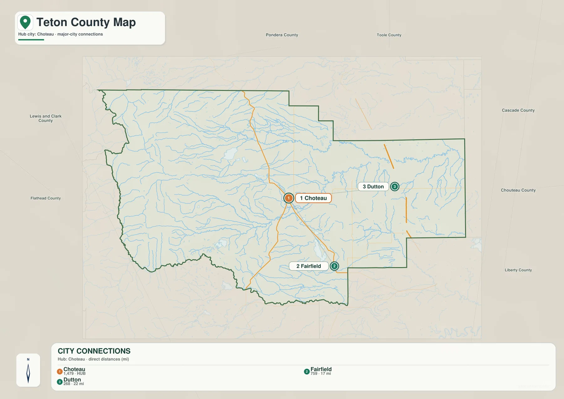
When the connection map is compared with the road map, the reason these three places feel distinct becomes clearer. Choteau sits at the U.S. 89 and U.S. 287 junction, Dutton is close to the Interstate 15 corridor, and Fairfield occupies a separate position to the southeast. The county’s official community page also lists places such as Bynum, Pendroy, and Power, so the connection map is not intended as a complete settlement inventory. Instead, it gives a quick visual comparison of three prominent reference points. For trip planning, use it to understand the broad relationship among the towns, then switch to current navigation data for the actual route and mileage.
Choosing the right map for a specific question
A reader who needs general orientation should begin with the county map because it combines the boundary, place names, and the most recognizable highways. The elevation map is the better choice for explaining why the west looks and feels different from the plains around Choteau, Fairfield, and Dutton. For the Teton River forks, reservoirs, creeks, and lakes, the terrain-and-water map removes much of the road detail and makes the drainage network easier to follow. The connection map is the quickest option when the only question is how Choteau, Fairfield, and Dutton are positioned relative to one another. Moving between maps by purpose is more useful than expecting one sheet to answer every geographic question.
The original JPG files measure 3638 by 2572 pixels, which gives enough resolution for close on-screen viewing and practical A3 printing. The county map works well in reports or worksheets that need roads and community names, while the water and elevation maps are more useful for lessons about rivers, relief, and the mountain-to-prairie transition. The connection map can serve as a simple locator diagram when too much detail would distract from the three main reference points. The maps are designed for broad geographic understanding. Surveying, engineering, flood-safety decisions, navigation, and other field work should rely on the latest official or specialized sources instead.
Frequently Asked Questions
What changes most quickly when traveling west from Choteau?
The terrain changes much more dramatically than the settlement pattern. West of Choteau, the broad lower country rises into the Rocky Mountain Front, where the elevation map shows tightly packed ridges and valleys. The highest terrain is concentrated near the western edge, while Choteau remains in the lower foothill-to-plains transition east of the main mountain belt.
Which map is best for the Teton River forks and the reservoirs?
Use the terrain-and-water map. It labels the North Fork and South Fork Teton River, the Teton River, several creeks, and major reservoirs including Bynum and Pishkun. It is intended for regional reference only and should not be used to determine flood hazard, water depth, navigation conditions, parcel boundaries, or legal water rights.
Do the 17-mile and 22-mile labels show road mileage from Choteau?
No. The city-connections map uses straight-line distances from Choteau to Fairfield and Dutton. Actual driving mileage will be longer or otherwise different depending on the route, road conditions, and exact start and end points. Use the connection map for direction and spacing, then consult current road or navigation information for travel.
Map File Information
The download contains the Teton County boundary and roads map, city-connections map, terrain-and-water map, and elevation map as original high-resolution JPG files.
- Included Files: Use only the versions confirmed in the article and supplied images
- File Type: Use the confirmed download contents
- Intended Use: Printing, education, presentations, and map-based projects
Related Maps
Sources and references
- Teton County Montana official website — county overview and Rocky Mountain Front context
- Teton County Communities — Choteau, Fairfield, Dutton, Bynum, Pendroy, and other local communities
- U.S. Census Bureau QuickFacts: Teton County, Montana — basic county statistics
- Teton County Growth Policy — county background, agriculture, irrigation, and settlement context
- USGS National Hydrography — national water-feature reference
- USGS 3D Elevation Program — elevation-data reference
Green Map creates custom-edited map images using open geographic data sources such as geoBoundaries, Natural Earth, OpenStreetMap, and government open data. These maps are edited visual materials, not raw data files, and are provided for education, documents, presentations, and graphic reference.