Montgomery County stretches from the towns and uplands around Montgomery City to the Missouri River along its southern edge. Route 19 provides the clearest north-south reference through the county, while Interstate 70 crosses the lower middle through the Danville, New Florence, High Hill, and Jonesburg corridor. Wellsville and Middletown sit farther north, Bellflower lies to the east, and the Loutre River cuts through the southern hills before reaching the Missouri River lowlands. High-resolution map files are available for download in the section below.
This page combines a road-and-boundary map, a simplified city distribution map, a terrain-and-water map, and an elevation map. High-resolution JPG originals are available together in one ZIP, so the same features can be examined at a larger scale or printed at A3 size without relying on the smaller WebP previews embedded in the article.
Table of Contents
Route 19 makes Montgomery City the clearest road reference
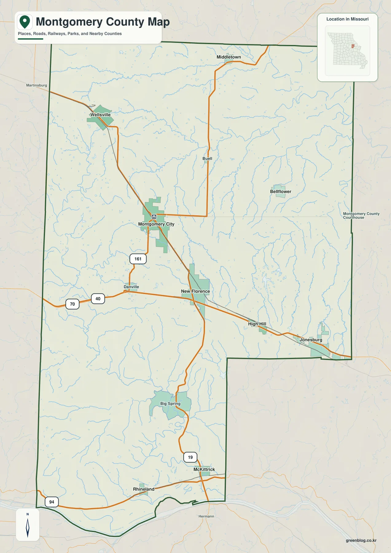
Montgomery City sits a little west of the county’s geographic center and works well as the first anchor on the general map. Route 19 passes through the city and continues north toward Middletown, while the same route runs south through New Florence, Big Spring, and McKittrick toward the Missouri River side of the county. Montgomery City is also the county seat, a role confirmed by Missouri state records and local historical sources.
Interstate 70 forms a separate east-west corridor south of Montgomery City. It enters the county near Danville, crosses Route 19 at New Florence, and continues through High Hill and Jonesburg before reaching the Warren County side. The map also labels U.S. 40 along this corridor, making the lower half of the county easy to orient even before smaller local roads are considered.
The road pattern changes toward the Missouri River. Rhineland lies near the southwest river side, while McKittrick sits farther east along Route 19 just north of the river. The southern county line bends with the Missouri River rather than following the long straight segments seen on the west and east sides, so road distance and straight-line distance can differ noticeably near the river bluffs.
The major towns are spread across several parts of the county
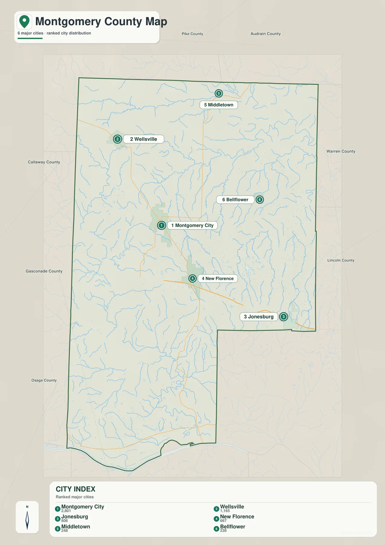
The city map highlights Montgomery City, Wellsville, Jonesburg, New Florence, Middletown, and Bellflower. Montgomery City occupies the central-western portion of the map, Wellsville is farther northwest, and Middletown sits close to the northern edge. Jonesburg and New Florence are concentrated in the southeastern I-70 corridor, while Bellflower stands apart in the east-central part of the county.
The city index ranks Montgomery City first, Wellsville second, Jonesburg third, followed by New Florence, Middletown, and Bellflower. The ranking is useful as a quick guide to the featured places, but their geographic positions matter more when using the maps for orientation. For example, Wellsville and Middletown help define the northern half, whereas Jonesburg and New Florence are much more closely associated with the I-70 corridor.
Bellflower’s position also helps explain why the county cannot be reduced to one road line. It lies east of Montgomery City and north of I-70, away from both the southern interstate towns and the northern pair of Wellsville and Middletown. Once these six locations are familiar, the more detailed water and elevation maps are easier to read because you can mentally place each valley or ridge relative to the nearest town.
Loutre River and Cuivre tributaries divide the rolling uplands
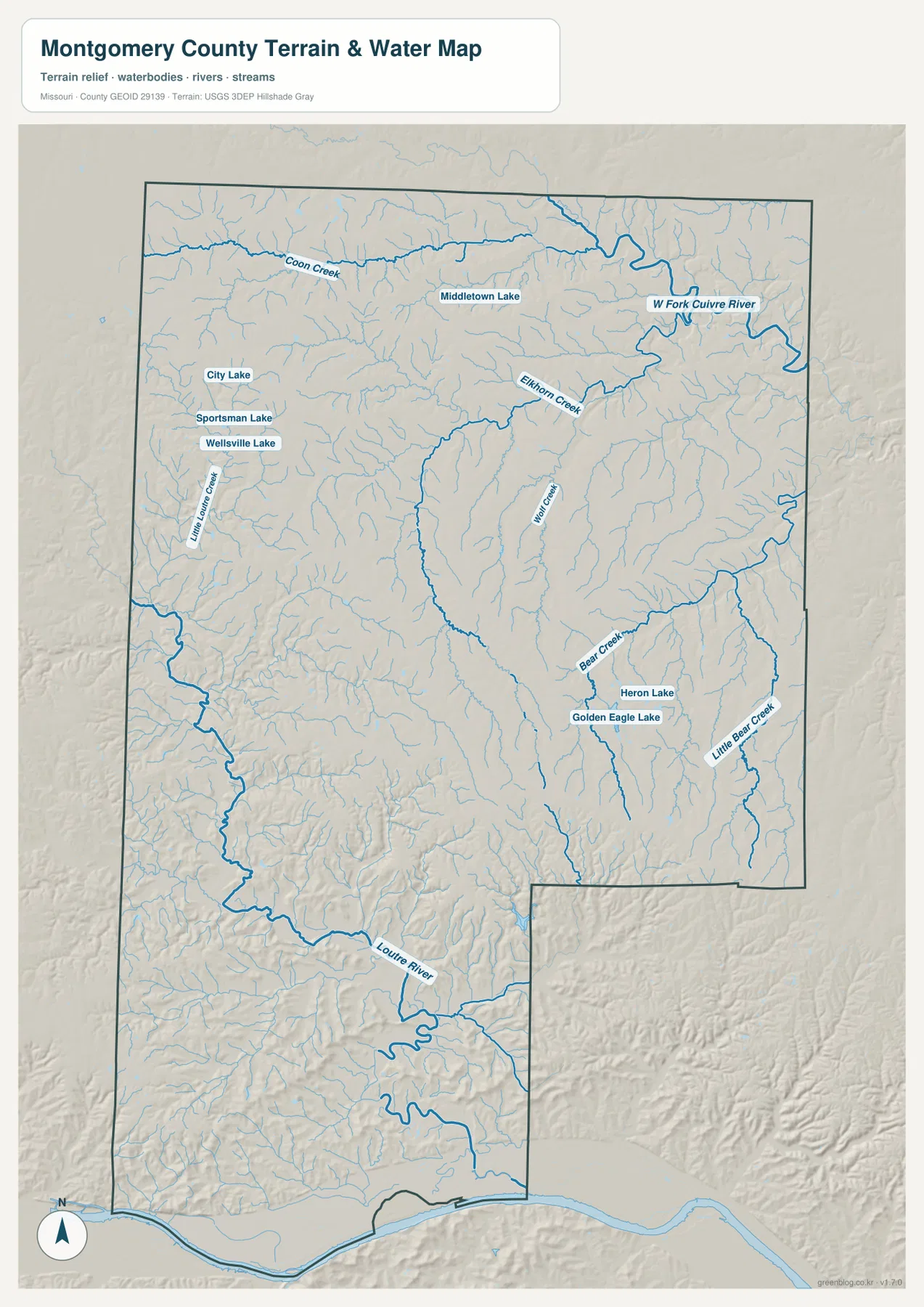
The Loutre River is the most prominent waterway in the southern part of the terrain map. It winds across the southwest and lower center before continuing toward the Missouri River. Little Loutre Creek approaches from the west, and the surrounding shaded relief shows that these streams occupy substantial valleys rather than crossing a flat plain.
Drainage in the northern and eastern half looks different. Coon Creek crosses the upper county, the West Fork Cuivre River occupies the northeast, and Elkhorn Creek, Wolf Creek, Bear Creek, and Little Bear Creek mark separate valleys farther south. These waterways do not all converge on the Loutre River, so the county’s ridges divide water toward different downstream systems.
Several small lakes provide additional reference points. City Lake, Sportsman Lake, and Wellsville Lake cluster near Wellsville; Middletown Lake appears farther north; and Heron Lake and Golden Eagle Lake sit in the southeast near the Bear Creek valley. The water map is intended to show the location of streams and water bodies, not to determine flood risk, water depth, navigability, parcel boundaries, or current water conditions.
Elevation ranges from about 150 to 286 meters
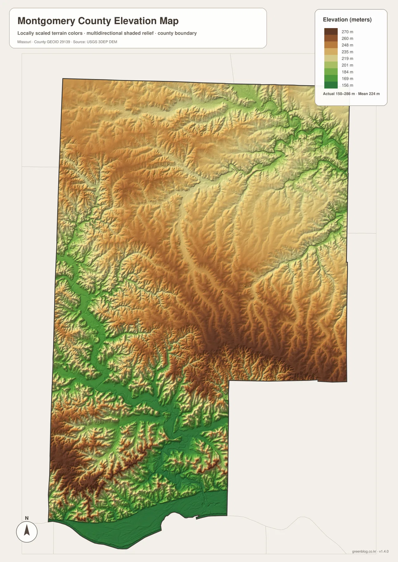
The elevation map reports an actual range of roughly 150 to 286 meters and a mean near 224 meters. The lowest greens are concentrated along the Missouri River at the southern edge and through the Loutre River valley in the southwest. Another clear low corridor follows the West Fork Cuivre River in the northeast, showing that the largest stream valleys sit well below the surrounding ridges.
Higher ground covers much of the central and southeastern interior. Brown and dark tan ridges extend between the tributary valleys, and the terrain along Route 19 south of Montgomery City alternates repeatedly between higher crests and lower stream cuts. Interstate 70 also crosses rolling country rather than a completely level surface, with many smaller tributaries carving through the hills on either side.
The relationship becomes easiest to see when the elevation and water maps are compared side by side. Green corridors frequently match the labeled rivers and creeks, while the warmer colors occupy the ridges between them. The elevation map is a generalized county-scale surface, so it is appropriate for understanding broad relief but not for engineering, construction drainage, property-level elevation decisions, or survey-grade measurements.
Choose the map by the question you need to answer
Use the general county map first when roads and town locations matter most. Montgomery City and Route 19 provide a strong north-south reference, and I-70 quickly locates New Florence, High Hill, and Jonesburg. The city map is cleaner when you only need the relative positions of the six highlighted towns without the distraction of every creek or smaller road.
For rivers, creeks, and local lakes, the terrain-and-water map carries far more useful detail. After locating the Loutre River, West Fork Cuivre River, Coon Creek, or Bear Creek there, switch to the elevation map to see how each waterway follows a lower corridor between ridges. This is especially effective in the southwest, where the Loutre valley drops toward the Missouri River, and in the northeast around the Cuivre drainage.
The downloadable JPG originals contain more pixels than the WebP previews on the page, making them better for enlargement, A3 printing, classroom handouts, reports, and personal reference. They remain general-purpose maps, however. Legal boundaries, land ownership, live road restrictions, flood status, and precise site elevations should always be checked against the appropriate current official source.
Frequently Asked Questions
Where does Route 19 meet Interstate 70 in Montgomery County?
Route 19 runs south from Montgomery City and meets Interstate 70 at New Florence. From there, I-70 continues west toward Danville and east through High Hill and Jonesburg, making the junction one of the easiest road references in the county.
Where is the lowest terrain shown on the elevation map?
The lowest elevations are concentrated along the Missouri River at the southern boundary and through the Loutre River valley. The West Fork Cuivre River in the northeast also follows a low corridor, while much of the central and southeastern interior rises onto higher ridges.
Which small lakes are labeled on the terrain-and-water map?
The map labels City Lake, Sportsman Lake, and Wellsville Lake near Wellsville, Middletown Lake in the north, and Heron Lake and Golden Eagle Lake in the southeast. The high-resolution JPG makes these names easier to inspect than the smaller on-page preview.
Map File Information
The download ZIP contains high-resolution JPG versions of the Montgomery County general map, city map, terrain-and-water map, and elevation map.
- File Type: JPG
Related Maps
Sources and References
Boundary and road reference data are supported by U.S. Census Bureau TIGER/Line, water features by USGS National Hydrography, and elevation data by the USGS 3D Elevation Program. Local historical context, including the county-seat history of Montgomery City, is available from the Montgomery County Historical Society.
Green Map creates custom-edited map images using open geographic data sources such as geoBoundaries, Natural Earth, OpenStreetMap, and government open data. These maps are edited visual materials, not raw data files, and are provided for education, documents, presentations, and graphic reference.