Macon County sits in north-central Missouri, where the city of Macon anchors an east-west and north-south road pattern built around U.S. 36 and U.S. 63. Smaller communities are spread across the county rather than clustered in one continuous urban area: La Plata and Atlanta are in the north, while Bevier, Callao, and New Cambria extend west from Macon. The maps on this page show those relationships together with the county boundary, streams, lakes, and relief, and the high-resolution JPG versions can be downloaded from the map file box below.
The county becomes much easier to understand when Macon is used as the starting point. U.S. 36 crosses the central part of the county and links Macon with Callao and New Cambria to the west. U.S. 63 runs through Macon toward La Plata near the northern boundary. Waterways do not follow that road pattern: the Chariton River system occupies the western side, the East Fork Little Chariton River runs through the interior, and the Middle Fork Salt River drains the east. That contrast between transportation corridors and stream valleys is one of the most useful things to compare across the four supplied maps.
Table of Contents
A county organized around Macon and the U.S. 36 corridor
The general county map combines the boundary, nearby counties, roads, rail lines, settlements, and streams. Adair County lies to the north, Linn and Chariton counties are on the west side, Randolph County is to the southwest, and Monroe, Knox, and Shelby counties appear along the east and southeast. The outline is not a simple rectangle; several steps and offsets in the boundary make the county shape recognizable when it is compared with surrounding jurisdictions.
U.S. 36 is the most obvious east-west route on the map. It enters from the west near New Cambria, passes Callao, continues through the Macon area, and leaves the county toward the east. U.S. 63 forms the strongest north-south route, connecting Macon with La Plata and continuing beyond the county. Missouri Route 3 crosses the western-central part of the county near Callao, Route 149 serves the New Cambria area, Route 129 appears near the western edge, and Route 156 crosses the north toward La Plata.
Those numbered routes are only part of the transportation picture. Macon County’s Road and Bridge Department states that it maintains roughly 900 miles of roads in unincorporated areas, along with hundreds of bridges. That helps explain why the general map contains so many smaller lines crossing creeks and rolling ground. For an overview, it is usually best to identify U.S. 36, U.S. 63, and the towns first, then use the smaller roads only after the larger pattern is clear.
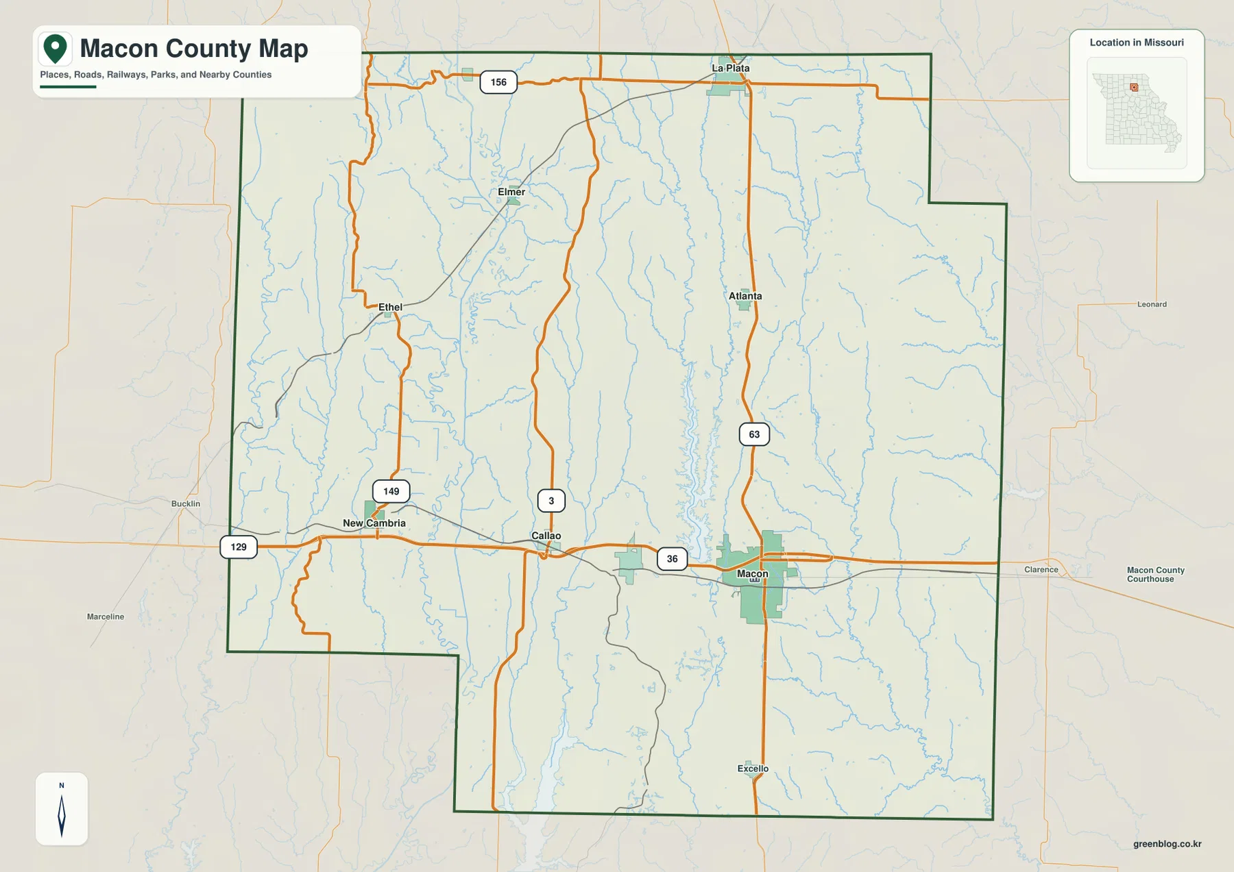
This map is designed as a geographic reference rather than a turn-by-turn navigation product. It is particularly useful for seeing how Macon relates to the smaller towns, where the main highways cross the county line, and how transportation routes sit among stream valleys. Someone looking for the courthouse area, a town-to-town orientation, or a printable county overview will generally find this version the best place to begin.
Six mapped towns reveal two different settlement patterns
The city map separates six communities from the denser background detail and ranks them by the population values used in the map index. Macon is shown as the largest, followed by La Plata, Bevier, Atlanta, Callao, and New Cambria. The important geographic point is not only the ranking. Macon sits in the east-central part of the county at the U.S. 36 and U.S. 63 crossroads, while the remaining towns form a northern group and a westward string along or near the U.S. 36 corridor.
La Plata is close to the northern county line and the U.S. 63 corridor. Atlanta is farther southeast, so the two northern towns are separated rather than forming a single continuous built-up strip. Bevier lies relatively close to Macon on the west side, while Callao and New Cambria extend the settlement pattern farther west. This distribution makes the county feel very different from a suburban county where neighboring cities merge into one broad developed area.
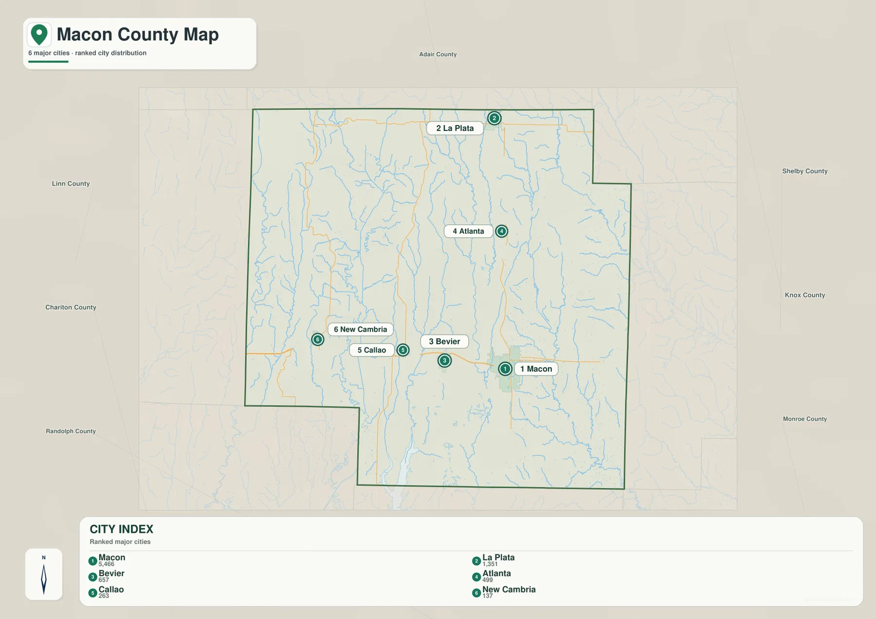
The simplified city view is helpful when labels on the general map feel crowded. It lets a reader find the six major named communities quickly, then return to the road map for detailed connections. Because this particular city map is a ranked location view rather than a driving-distance diagram, it should not be used to infer road mileage or travel time between towns. Actual routes can bend around waterways, junctions, and local road conditions.
The relationship between towns and highways is especially clear around Macon and the western communities. Macon sits at the main highway intersection, Callao is close to the Route 3 and U.S. 36 area, and New Cambria is farther west where Route 149, rail, and the east-west corridor come together. La Plata has a different orientation because its strongest road connection is north-south along U.S. 63. Seeing those differences helps explain why the county does not have one single settlement axis.
Long Branch Lake links the interior to the Little Chariton system
The terrain and water map shifts attention from roads to drainage. On the west side, the Chariton River and Old Channel Chariton River run generally north to south, joined by tributaries such as Bull’s Creek. Through the interior, the East Fork Little Chariton River forms a long valley, while the Middle Fork Salt River runs through the eastern part of the county. These three broad drainage areas show that Macon County is divided among different river systems rather than being organized around one central stream.
Long Branch Lake is the most prominent lake on the map and lies north of Macon along the East Fork Little Chariton River system. Macon Lake is farther south on the same general interior drainage line. Other named waters include Santa Fe Lake, Love Lake, and Atlanta City Lake in the north, plus Ethel Lake and Speno Lake in the west. Thomas Hill Reservoir reaches the southern edge of the mapped county area, adding another large water feature near the boundary.
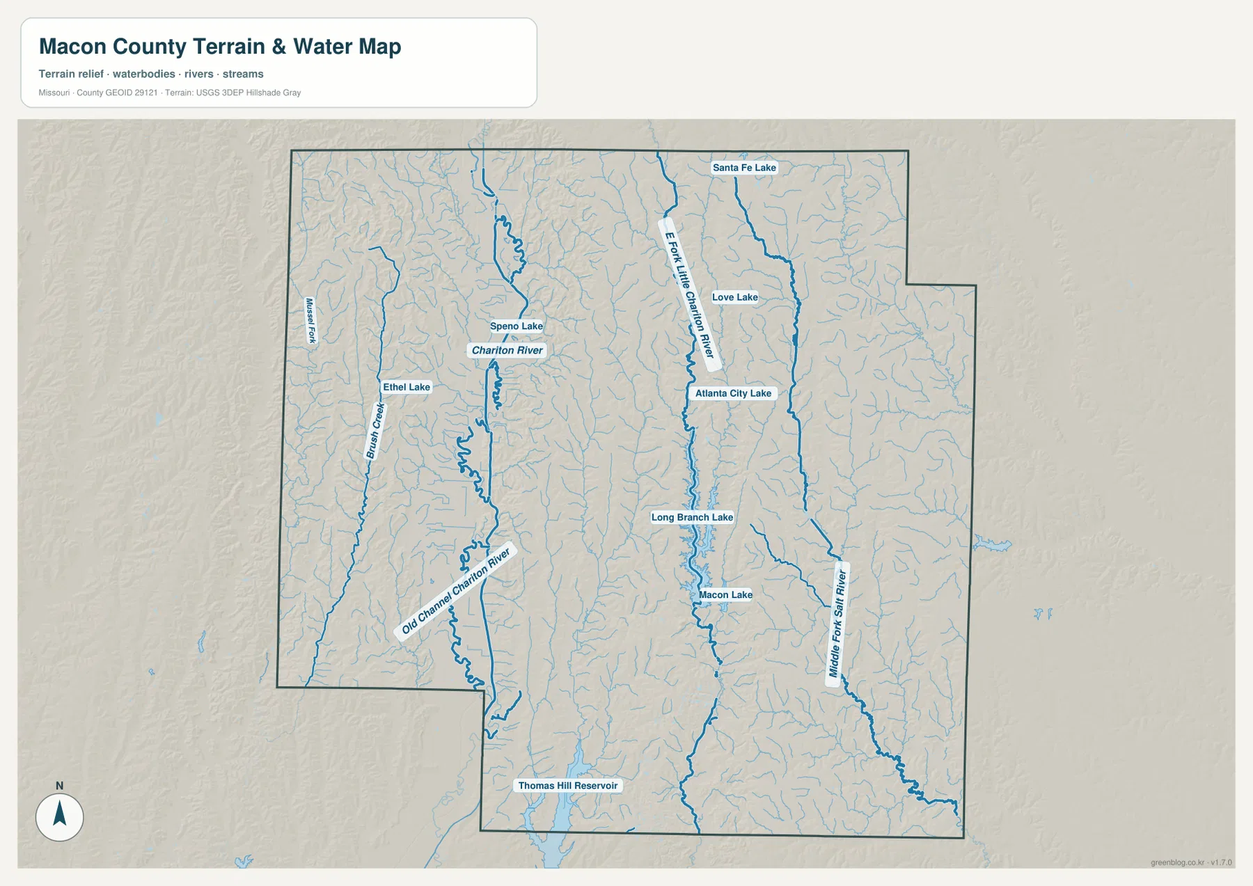
Long Branch State Park provides useful local context for the lake. Missouri State Parks describes the area as rolling northern Missouri farmland meeting remnants of the Chariton River Hills, with the lake serving as a major recreation feature. That description matches what can be seen when the water and elevation maps are compared: the lake occupies a lower valley while the surrounding land rises into narrow, rolling uplands.
The water map is not a flood map, navigation chart, parcel map, or water-depth product. It is best used to locate lakes, major streams, and drainage relationships. Anyone planning boating, fishing, flood preparation, or access to public land should use the current rules and official operational maps from the responsible agencies in addition to this geographic reference.
Elevation colors separate broad valleys from rolling uplands
The elevation map uses a local color scale to make subtle relief easier to see. Its legend gives an actual elevation range of about 200 to 309 meters and a mean of 251 meters. Low areas appear in green, while higher ridges shift through yellow and brown. Macon County is not mountainous, but the shaded relief reveals that it is far from uniformly flat. Numerous stream valleys divide the uplands into long, narrow ridges.
The Chariton River valley on the western side forms one of the clearest low corridors. A second long low area follows the East Fork Little Chariton River through the interior, including the Long Branch Lake area. Higher ground appears on both sides of these valleys, with especially distinct brown and tan ridges across parts of the west and north. The eastern half also contains repeated ridges between tributaries, although the relief is generally expressed as rolling terrain rather than steep mountain slopes.
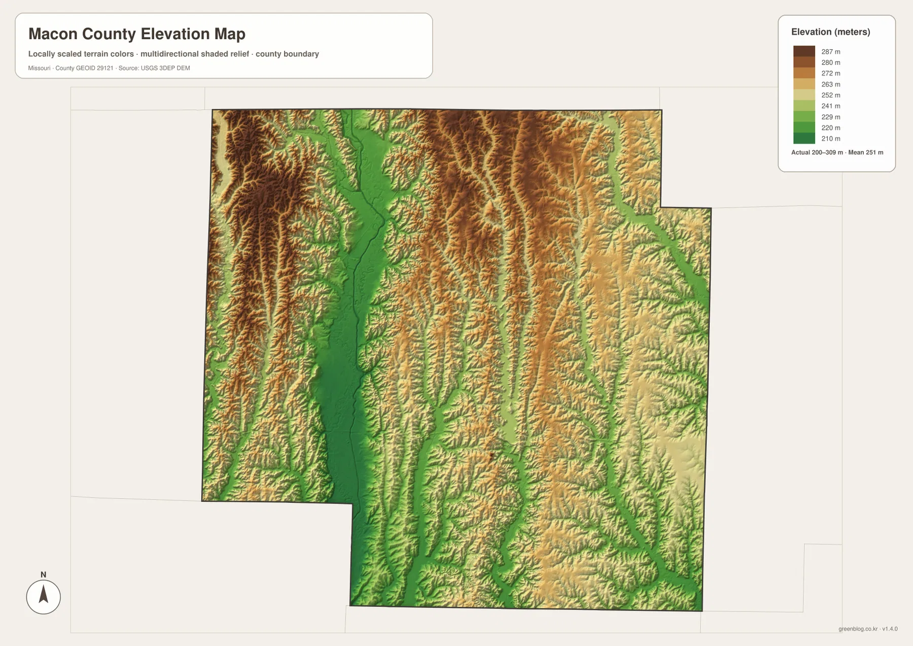
The elevation surface is generalized for regional reading. It should not be treated as a survey-grade measurement for a property, building pad, drainage project, or engineering design. Its value is comparative: it shows why lakes and streams occupy narrow green corridors, why many roads cross repeated low and high sections, and how the county’s rolling landscape differs from a broad, featureless plain.
The strongest visual relationship in the elevation map is the repeated pairing of a low stream corridor with higher ground on both sides. West of the county center, the Chariton valley creates a broad green ribbon. Farther east, another lower strip follows the Little Chariton system. Between them are elongated uplands that can be followed for several miles before they are cut by tributaries. This pattern gives the county a ribbed appearance in shaded relief and helps explain why a two-dimensional road map alone cannot show the whole landscape.
Around Long Branch Lake, the same relationship is even easier to see because the water body provides a fixed landmark. The lake occupies the low interior corridor, and the surrounding terrain rises quickly enough to produce clear color changes on both sides. That does not imply dramatic cliffs. Instead, it shows a series of modest slopes and ridges that collectively create the rolling character associated with this part of northern Missouri.
The western side has a different visual texture. The Chariton River, Old Channel Chariton River, Bull’s Creek, and many small tributaries divide the land into numerous narrow pieces. Ethel Lake and Speno Lake add small water features to that network. When the general map and the terrain map are viewed together, the road pattern makes more sense because local roads repeatedly cross or skirt these stream corridors.
Northern Macon County also benefits from comparing map types. La Plata is easy to locate on the road and city maps, but the water map adds nearby small streams and lakes, while the elevation view shows the rolling ground between them. Atlanta sits farther south and east, close to a different set of water features. The two towns may both be described as northern communities, yet their immediate geographic settings are not identical.
The same is true of the towns west of Macon. Bevier is relatively close to the county’s main city, while Callao sits at a more distinct highway junction and New Cambria lies farther toward the western drainage area. Moving west along U.S. 36 therefore changes not only the town sequence but also the surrounding stream pattern and relief. This is a useful example of why one map can answer the “where” question while another explains the landscape around that location.
Choosing the right map for a specific task
For county orientation, the general map is the most complete choice because it combines boundaries, highways, smaller roads, towns, rail lines, and streams. It works well when the goal is to understand where Macon County sits relative to its neighbors or to trace the main transportation routes. If the task is simply to compare the largest mapped towns, the city map removes much of that background detail and keeps attention on the six labeled communities.
The water map is better for questions centered on Long Branch Lake, the Chariton River, or the county’s many tributaries. It gives streams stronger visual emphasis and includes terrain shading, making drainage relationships easier to follow. The elevation map is the best companion when the question involves low valleys and higher ridges. Used side by side, the water and elevation views show how the larger lakes and river channels occupy lower terrain while the uplands form the divides between drainage systems.
For printing, the downloadable JPG files are preferable to the smaller WebP images displayed in the article. Each original map is 3638 by 2572 pixels. The archive contains the general county map, city map, terrain and water map, and elevation map. A classroom handout might use the general map for labels and the elevation map for a physical-geography exercise, while a local-history or recreation document may benefit more from the road and water views.
Practical limits and current local context
The maps are intended for geographic reference, education, printing, and general orientation. They are not substitutes for legal boundary records, parcel surveys, construction plans, emergency routing, or current road-closure information. Small roads and access conditions can change, water levels vary, and a generalized shaded-relief surface cannot provide the precision required for engineering or property work.
For current local information, Macon County’s official website provides county services and GIS access, while the Road and Bridge Department explains its maintenance responsibilities. Missouri State Parks maintains the official information for Long Branch State Park and lake-related recreation areas. These sources are useful when a map location needs to be connected with a current public service, road responsibility, or park rule.
Population figures should also be kept separate from geographic map reading. The city index is useful for showing the relative size and location of the six mapped communities, but it is not a complete demographic profile of the county. U.S. Census Bureau resources such as QuickFacts are the better source for current county-level population, household, and economic statistics, while these maps focus on physical location and spatial relationships.
Frequently Asked Questions
Which map is best for finding Long Branch Lake?
The terrain and water map is the clearest choice because Long Branch Lake is labeled prominently north of Macon along the East Fork Little Chariton River system. If you also want to understand the surrounding hills and valley, compare it with the elevation map, where the lake sits within a lower green corridor bordered by higher rolling ground.
Can I follow U.S. 36 from Macon toward Callao and New Cambria?
Yes. The general county map shows U.S. 36 crossing Macon and continuing west toward Callao and New Cambria. Bevier is also close to that central east-west corridor. The map is useful for orientation, but driving mileage, closures, and turn-by-turn directions should be checked with a current road or navigation service.
What files are included for printing?
The download archive contains four high-resolution JPG files: the general county map, city map, terrain and water map, and elevation map. Each original image is 3638×2572 pixels, which gives more detail for printing and document layout than the smaller WebP previews used in the article.
Map File Information
The download package includes the general county map, city map, terrain and water map, and elevation map as high-resolution JPG files.
- File Type: JPG
Related Maps
Sources and references
The following official and public sources are useful for checking county services, roads, water features, boundaries, and elevation data.
- Macon County, Missouri official website – county government services and local information
- Macon County Road and Bridge Department – county road and bridge responsibilities
- Long Branch State Park – official lake, park, and recreation information
- U.S. Census Bureau TIGER/Line Shapefiles – boundary and transportation geography data
- USGS National Hydrography – rivers, streams, and waterbody data
- USGS 3D Elevation Program – elevation and terrain reference data
Green Map creates custom-edited map images using open geographic data sources such as geoBoundaries, Natural Earth, OpenStreetMap, and government open data. These maps are edited visual materials, not raw data files, and are provided for education, documents, presentations, and graphic reference.