Gasconade County lies in east-central Missouri, where the Missouri River forms the northern edge and the interior is cut by the Gasconade River, the Bourbeuse River, and a dense network of smaller creeks. Hermann is the strongest northern reference along the Missouri River, while Owensville anchors the southern half of the county. Rosebud, Bland, Gasconade, and Morrison occupy different parts of a long rural landscape. This page compares roads, ranked communities, water features, and elevation, and the same map themes are available as high-resolution JPG files in a single ZIP for printing or offline reference. High-resolution map files are available for download in the section below.
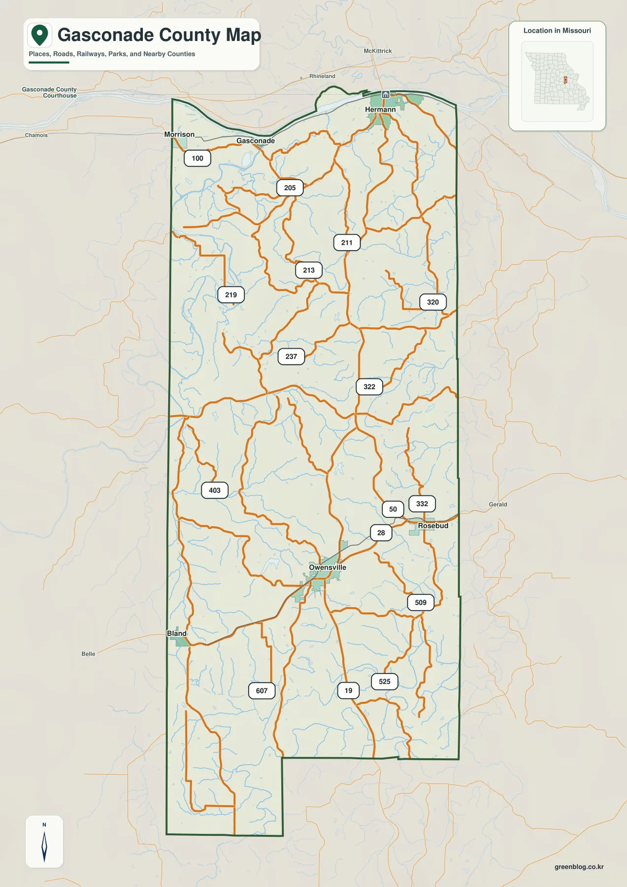
The general county map immediately shows a strong north-south contrast. Route 100 helps organize the river towns near Hermann, Gasconade, and Morrison, while U.S. 50 and Routes 28 and 19 are useful around Owensville and Rosebud farther south. Between them lies an extensive network of streams and rolling hills. Looking at the road map alone gives the broad layout, but comparing it with the water and elevation layers makes the relationship between river valleys, ridges, and communities much clearer.
Table of Contents
Hermann and the Missouri River define the northern edge
Hermann sits close to the Missouri River in the northeastern part of Gasconade County. The county boundary follows the broad river corridor across much of the north, and Route 100 provides a useful road reference through the same general area. West of Hermann, the map labels Gasconade and Morrison, creating a chain of northern places that can be used to orient the entire county.
The official Gasconade County website describes the county as being in east-central Missouri and states that the Missouri River forms its northern border. It also places the county within the Missouri Rhineland, a region strongly associated with German immigrant settlement. That background adds context to the river-town pattern visible on the map, especially around Hermann and the northern boundary.
Owensville, Rosebud, and Bland organize the southern half
Owensville sits near the middle of the southern half of Gasconade County and is a convenient reference for Routes 28 and 19. Rosebud lies to the east near U.S. 50, while Bland is positioned close to the southwestern side of the county. The three communities are separated by broad rural areas rather than forming a continuous urban corridor, which is typical of the county’s dispersed settlement pattern.
The roads around Owensville branch in several directions through rolling country. Around Rosebud, U.S. 50 and Route 28 provide stronger east-west orientation, while Bland is closer to the western boundary and the rougher terrain visible on the elevation map. The county map is best used to understand these relative positions; current turn-by-turn routing and road conditions should still be checked with a live navigation source.
Six ranked communities show the county’s settlement pattern
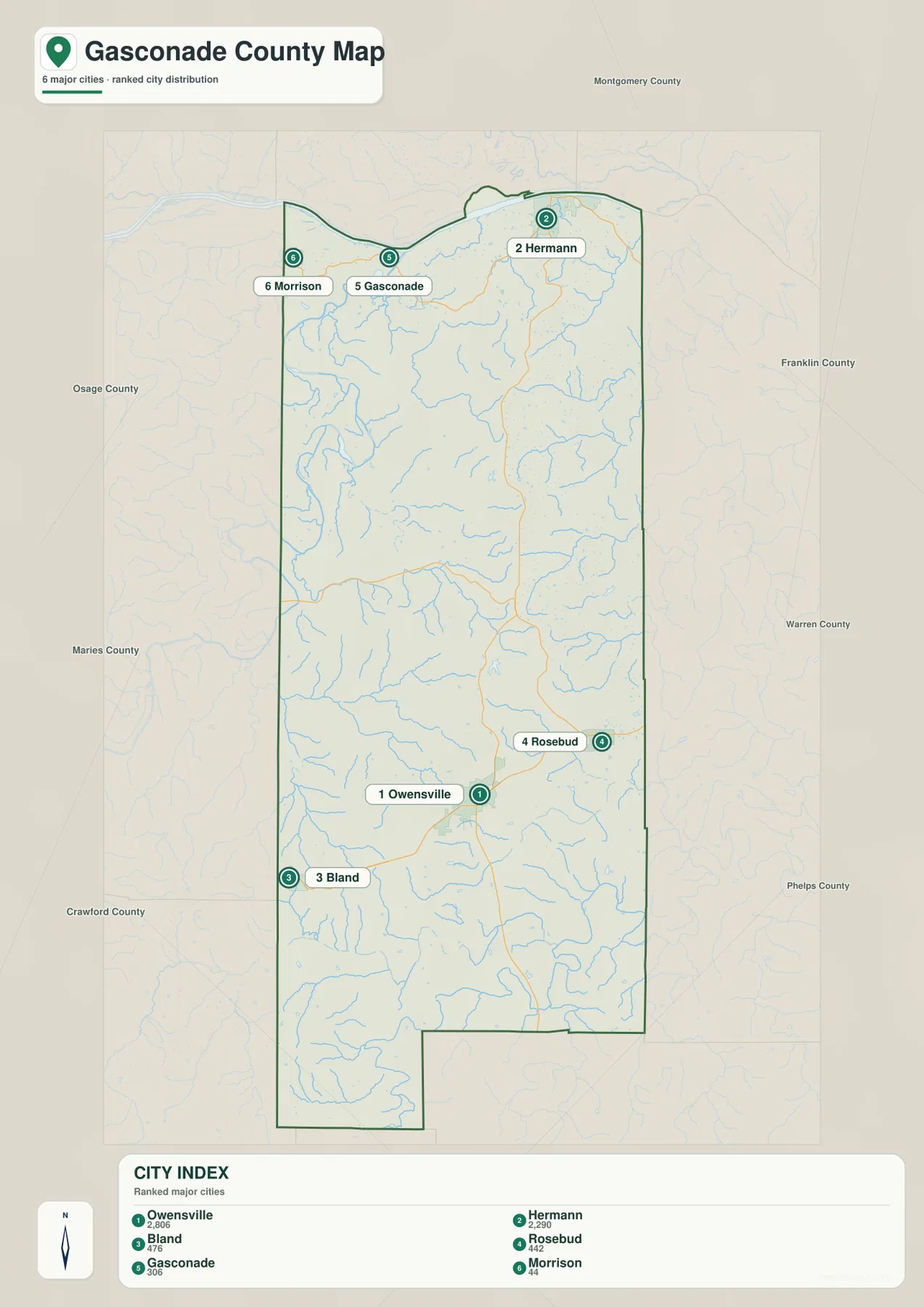
The city distribution map ranks Owensville first, Hermann second, Bland third, Rosebud fourth, Gasconade fifth, and Morrison sixth. The CITY INDEX also shows values of 2,806, 2,290, 476, 442, 306, and 44. These should be treated as values attached to the map’s ranking dataset rather than as claims about the latest official population totals.
The geographic pattern is more important than the numbers. Owensville and Rosebud occupy the southern interior, Hermann, Gasconade, and Morrison lie along or near the northern Missouri River corridor, and Bland sits farther southwest. The map is a ranked distribution view, not a road-distance diagram, so the numbered markers do not represent mileage or travel time.
Gasconade River bends through the western interior
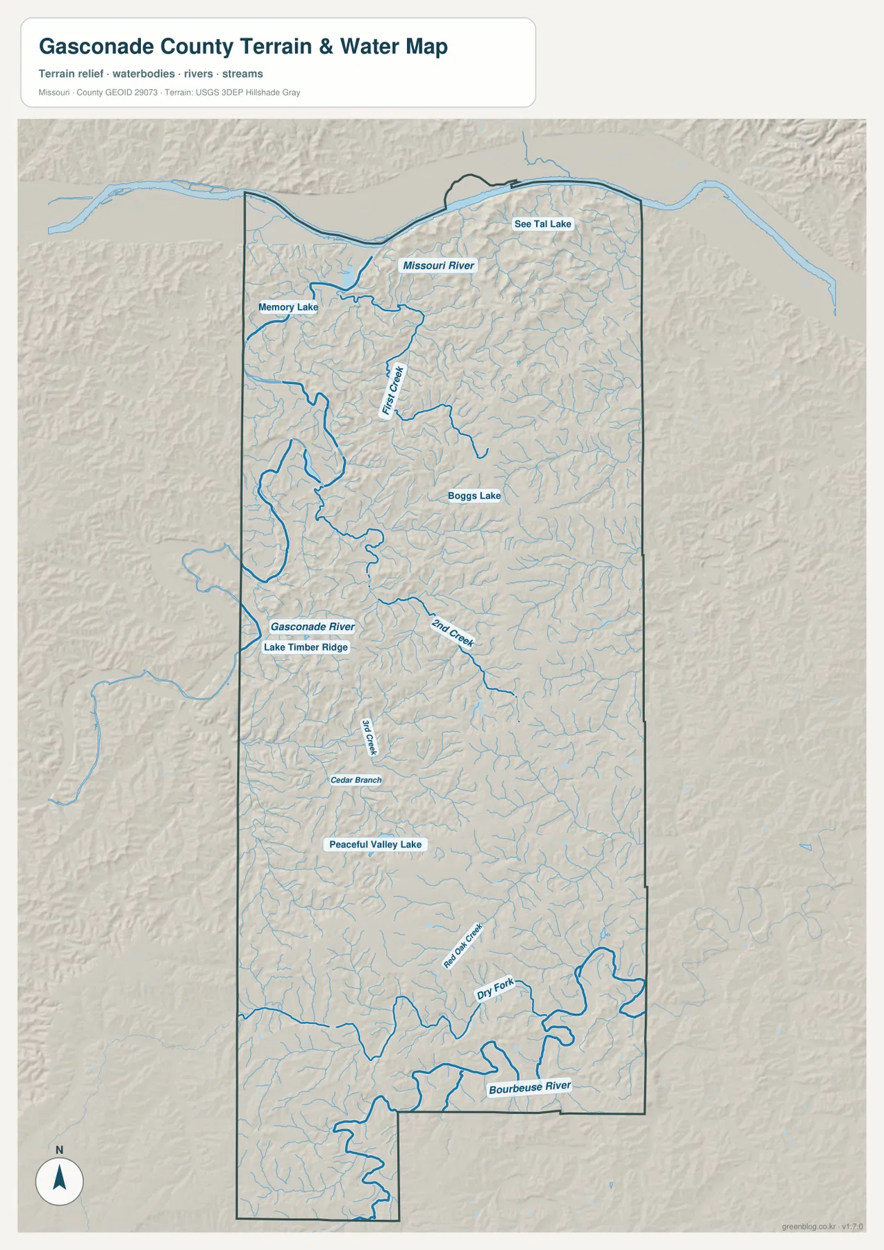
The Gasconade River is one of the largest water features on the terrain-and-water map. It curves through the western interior, creating a broad low valley and receiving smaller tributaries from surrounding hills. Lake Timber Ridge is labeled near the river and provides an additional local landmark. The western side of the county becomes much easier to understand once the river’s bends are visible.
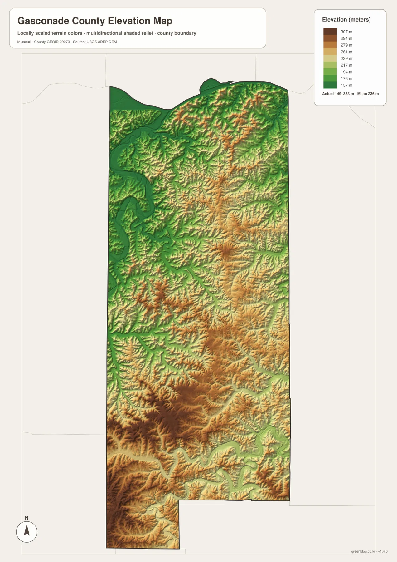
Several named creeks add detail to the same system. 2nd Creek and 3rd Creek appear farther east, while Flat Creek is prominent in the north. Numerous smaller tributaries fill the spaces between them. When the water map is compared with the elevation layer, these channels align with lower green corridors, while the ridges between them rise into lighter and warmer colors.
Bourbeuse River and Dry Fork shape the southeast
The Bourbeuse River crosses the southeastern portion of the map and is joined by a complex network of tributaries. Dry Fork is labeled just to the north, and Red Oak Creek appears in the same general part of the county. These channels create lower valleys south and east of the Owensville–Rosebud area and help explain the irregular ridge pattern visible on the shaded-relief layer.
This southeastern drainage area differs from the Gasconade River corridor farther west, giving the southern half of the county more than one major valley system. Following Dry Fork into the Bourbeuse River is a useful way to orient the landscape around Rosebud and the southern boundary. The water layer is intended for general geographic reference, not for flood forecasting, parcel boundaries, or navigation.
Small lakes provide additional local landmarks
The terrain-and-water map also labels Memory Lake, See Tal Lake, Boggs Lake, Lake Timber Ridge, and Peaceful Valley Lake. Memory Lake is in the northwest, See Tal Lake lies in the northeastern part of the county, and Boggs Lake appears farther south in the interior. Peaceful Valley Lake provides a useful landmark in the central-southern section.
These water bodies are much smaller than the Missouri, Gasconade, or Bourbeuse rivers, but they are helpful when matching a local area across map layers. Lake Timber Ridge, for example, can be used together with the Gasconade River to locate part of the western interior. Memory Lake and See Tal Lake help distinguish opposite sides of the northern section.
Elevation ranges from about 149 to 333 meters
The elevation map gives an actual mapped range of approximately 149 to 333 meters, with a mean near 236 meters. The Missouri River corridor in the north and the Gasconade River valley in the west appear in lower green shades. Higher ground spreads through much of the central and southern interior, where yellow, tan, and brown ridges are cut by narrow creek valleys.
The relief is especially pronounced in the southern half. Instead of one continuous high ridge, the county contains many branching uplands separated by tributary valleys. Dry Fork and the Bourbeuse River occupy lower corridors in the southeast, while the southwestern and south-central areas include some of the strongest high-ground shading. This map is suitable for broad county-scale comparison, not for survey-grade or engineering-grade elevation work.
Comparing Hermann and Owensville reveals two different settings
Hermann and Owensville make a useful two-place comparison because they occupy very different settings. Hermann is close to the Missouri River and the low northern edge of the county. Owensville lies inland among a much denser pattern of ridges and tributary valleys. The difference becomes obvious when both places are followed from the general map to the elevation layer.
The road network reflects the same contrast. Route 100 follows the northern river country, while Routes 28 and 19 help organize the Owensville area farther south. A reader who starts with these two towns can quickly build a mental map of the county: river lowlands in the north, a major western river valley, and increasingly dissected uplands through the central and southern interior.
County government in Hermann and Extension services in Owensville
Gasconade County’s official website provides county-government information centered on the courthouse in Hermann. The site also describes the Missouri River as the northern boundary and offers local background about the county. That makes it a useful companion to the map for readers who need administrative information after locating Hermann.
University of Missouri Extension maintains its Gasconade County office in Owensville and provides local agriculture, 4-H, education, and community resources. Together, these two public references reflect the map’s two strongest town anchors: Hermann for county government in the north and Owensville for many community services in the southern interior.
Choosing the right downloadable map
Use the general county map when roads, communities, and the county boundary are the priority. The ranked community map gives the quickest comparison of Owensville, Hermann, Bland, Rosebud, Gasconade, and Morrison. The terrain-and-water map is best for named rivers, creeks, and lakes, while the elevation layer shows the contrast between low river valleys and the higher interior.
The download ZIP contains high-resolution JPG versions of the same map themes shown on the page. They are useful for enlarging labels, printing a reference sheet, or comparing layers side by side. The files are intended for general geographic reference and do not replace live navigation, emergency warnings, legal parcel information, or professional surveying.
Frequently Asked Questions
What are the easiest towns to use as reference points in Gasconade County?
Hermann is the clearest northern reference because it is close to the Missouri River, while Owensville is the strongest reference in the southern interior near Routes 28 and 19. Using both towns makes the county’s north-south contrast easy to understand.
Do the numbers on the city map represent driving distance?
No. They are ranking markers and index values for Owensville, Hermann, Bland, Rosebud, Gasconade, and Morrison. They are not mileage or travel-time measurements.
What elevation range is shown on the Gasconade County map?
The elevation layer shows an actual range of about 149 to 333 meters, with a mean near 236 meters. Lower ground follows the Missouri River and Gasconade River valleys, while higher hills cover much of the central and southern interior.
Map File Information
Download the map files associated with this page for reference, printing, and compatible visual projects.
- Included Files: Use only the versions confirmed in the article and supplied images
- File Type: Use the confirmed download contents
- Intended Use: Printing, education, presentations, and map-based projects
Related Maps
Sources and references
- Gasconade County Official Website – county government, Missouri River boundary, and local background
- University of Missouri Extension – Gasconade County – Owensville county office and local programs
- U.S. Census Bureau TIGER/Line Shapefiles – county boundary and road data
- USGS National Hydrography – rivers, streams, and water features
- USGS 3D Elevation Program – elevation data
Green Map creates custom-edited map images using open geographic data sources such as geoBoundaries, Natural Earth, OpenStreetMap, and government open data. These maps are edited visual materials, not raw data files, and are provided for education, documents, presentations, and graphic reference.