Caldwell County in northwestern Missouri is easiest to orient around Hamilton, where U.S. 36 crosses Route 13. From that northern junction, Route 13 continues south toward Kingston and Polo, while the county’s eastern side includes Braymer and Breckenridge. The maps on this page combine county boundaries and roads, a ranked distribution of six major communities, named creeks and river channels, and a locally scaled elevation surface. The original high-resolution JPG versions of all four maps can also be downloaded together in one ZIP file. High-resolution map files are available for download in the section below.
The human geography has two useful reference points rather than a single dominant center. Hamilton is the largest town identified by the county’s local-history site and appears first in the supplied city ranking. Kingston is smaller on that city map but is the county-government center, positioned farther south on Route 13. Reading the two places together helps explain why the road map emphasizes Hamilton’s highway junction while county offices and courthouse history are associated with Kingston.
The physical landscape tells a different story. Shoal Creek winds across the middle of the county, Little Otter Creek enters from the north, and the Crooked River system occupies the southwest. On the elevation map, western and southwestern ridges are generally higher, while broader green lowlands open toward the center and east. The legend gives an actual county range of roughly 216 to 319 meters with a mean near 272 meters, so the important pattern is not mountain-scale relief but repeated ridges, narrow tributary valleys, and a lower central drainage corridor.
Table of Contents
U.S. 36 Crosses Route 13 at Hamilton Before Route 13 Runs South
The general county map is organized around two numbered routes. U.S. 36 crosses the northern part of Caldwell County from west to east, passing directly through Hamilton. Route 13 meets it there and then runs south through the interior toward Kingston and Polo. That simple T-shaped relationship makes Hamilton a strong visual anchor: once the U.S. 36-Route 13 junction is found, the rest of the county can be located by direction from it.
Kingston lies south of Hamilton on Route 13, while Route 116 creates a second east-west reference across the southern part of the county. Braymer sits near the southeastern side along that southern corridor, and Cowgill appears slightly north of Route 116. Breckenridge is farther northeast, near the eastern continuation of the U.S. 36 corridor. Together these places show that Caldwell County does not have one dense road web; instead, several long rural routes connect small communities across a broad agricultural and creek-cut landscape.
The road lines look relatively simple, but the terrain beneath them is not perfectly flat. Between Hamilton and Kingston, numerous small streams cross the interior before joining larger creek valleys. Shoal Creek bends through the middle of the county rather than following the straight survey lines of roads and boundaries. That contrast is useful when reading the map: numbered routes provide the clearest travel framework, while the creeks explain many of the dips and bends in the surrounding terrain.
The county outline itself is mostly regular compared with the winding interior drainage. For general orientation, this makes the outer boundary easy to recognize and shifts attention to the road-and-place relationships inside it. The map is well suited to locating Hamilton, Kingston, Braymer, Breckenridge, Polo, and nearby corridors, but it is not a live navigation product. Current construction, closures, and local-road access should always be checked with up-to-date transportation information.
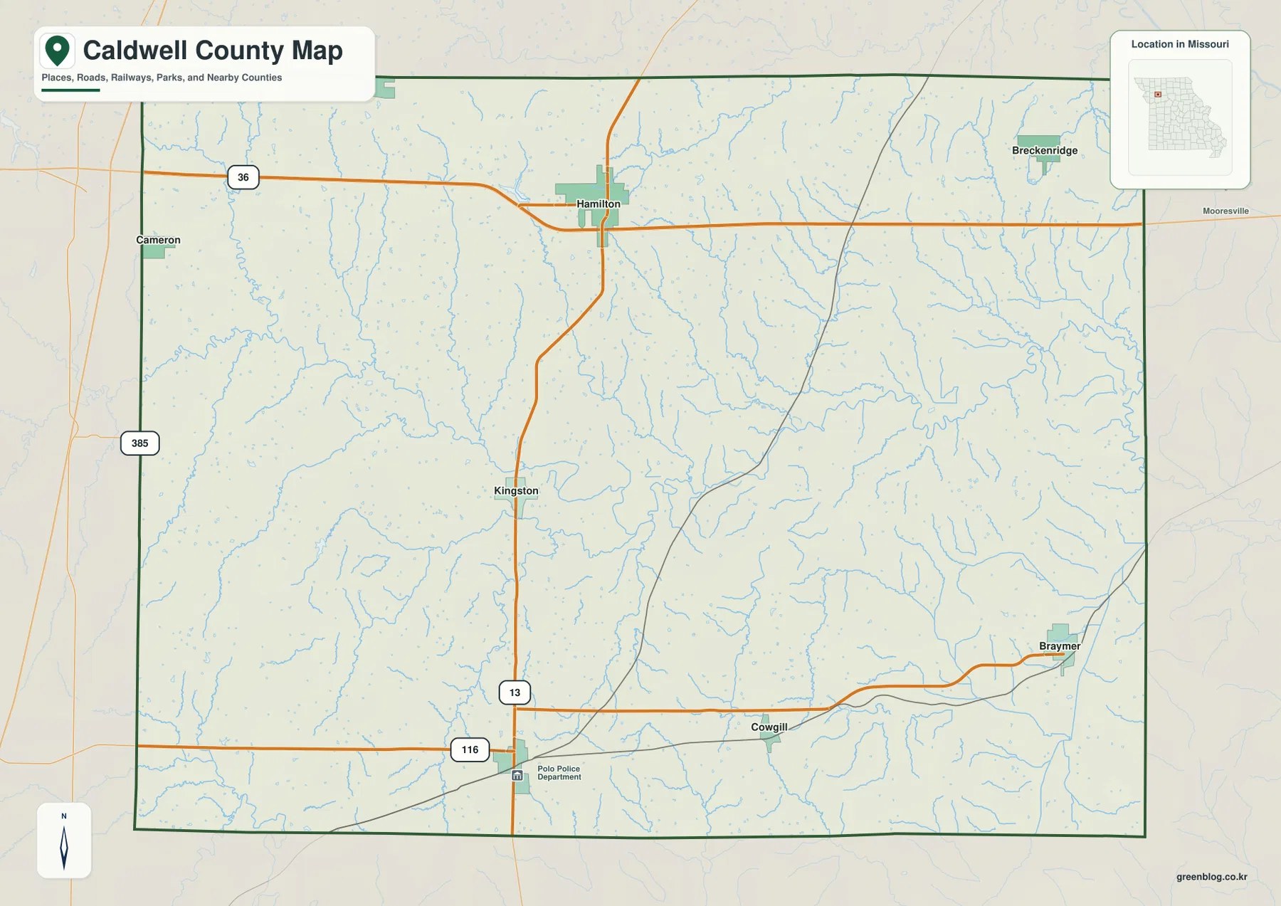
For a first countywide look, this is the most practical of the four maps because roads and communities appear together. It shows why Hamilton works as a northern gateway, how Kingston relates to the county’s central corridor, and where Braymer lies in relation to the southern road network. The other maps add detail about city distribution and physical geography, but this road map provides the clearest starting framework.
Six Major Communities Spread from Kidder and Hamilton to Braymer and Polo
The city-distribution map removes much of the road detail and emphasizes six selected communities. Its index ranks Hamilton first, Braymer second, Kidder third, Breckenridge fourth, Polo fifth, and Kingston sixth. The purpose is comparative rather than exhaustive: it provides a quick view of the selected places and their relative positions, not a complete municipal inventory. Exact current population figures or legal municipal classifications should be confirmed with Census and local-government sources.
The spatial pattern is widely dispersed. Hamilton occupies the north-central area, Kidder sits toward the northwest, and Breckenridge is near the northeast. Kingston is closer to the center, Polo lies to the south, and Braymer is farther southeast. Because the six places occupy several different parts of the county, the map gives a much clearer sense of settlement spread than a simple list of town names would.
One of the most useful comparisons is Hamilton versus Kingston. Hamilton’s larger rank and highway position make it visually prominent, while Kingston’s importance comes from county government rather than size. Caldwell County’s own Hamilton history page describes Hamilton as the county’s largest town, and the Kingston history page documents the long courthouse tradition there. On the maps, that difference appears as a major northern road junction at Hamilton and a smaller but centrally placed county seat on Route 13.
Neighboring counties are labeled around the outside of the city map, including Daviess to the north and Livingston, Carroll, Ray, Clinton, and DeKalb around the other sides. Those labels help place Caldwell County within the larger northwestern Missouri road network. Kidder and Hamilton are closer to the northern edge, while Braymer and Polo provide useful references for the lower half. The distribution also explains why U.S. 36 matters so much to the northern communities even though it does not pass through the southern half.
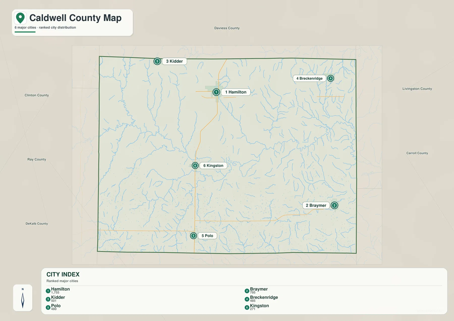
This version is useful when the main question is where the principal communities lie rather than how to drive between them. It does not draw connector distances or direct travel lines, so there is no implied mileage to interpret. For actual routes, return to the county road map to identify U.S. 36, Route 13, and Route 116, then use current navigation data for detailed travel planning.
Shoal Creek Organizes the Central Drainage of Caldwell County
The terrain-and-water map makes Shoal Creek the clearest natural reference line. It enters from the west, bends repeatedly through the middle of the county, and continues toward the eastern side. Several smaller channels join it from both directions. Little Otter Creek descends from the north and reaches the central-eastern drainage, while Tom Creek runs southward through the north-central area. Shaded relief makes the creek valleys visible as low corridors rather than simply showing blue lines on a blank background.
The western side contains a dense set of smaller tributaries, including Brush Creek, Mill Creek, and Goose Creek. Their short branching patterns correspond with the more dissected western relief visible on the elevation map. As these channels approach the middle of the county, they feed broader low areas associated with Shoal Creek. This transition from many small headwater valleys to a larger central drainage corridor is one of the defining physical patterns on the supplied maps.
Southwest Caldwell County has a second important drainage group. Log Creek and Long Creek occupy that area, while Crooked River and East Fork Crooked River appear near the southern edge. Timber Lake is also labeled close to the southwest corner. On the east side, North Mud Creek forms a long north-south feature, and Panther Creek and Lick Fork appear farther north and northeast. The result is a county crossed by many medium and small channels rather than dominated by a single large river.
Shoal Creek is especially useful for matching the water map to the elevation map. A broad green low corridor follows much of its central and eastern course, and lower branches extend northward along Little Otter Creek and Tom Creek. In the southwest, the Crooked River system follows another low route between higher ridges. The two maps therefore work as a pair: the water map supplies names and channel positions, while the elevation map explains the valleys those channels occupy.
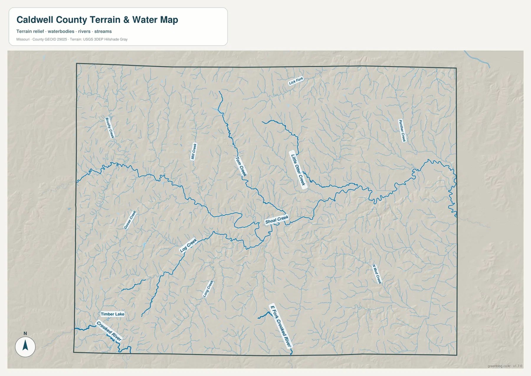
This water-reference map should not be used as a regulatory flood map, parcel map, or navigation chart. It shows general hydrography and terrain context, not FEMA flood zones, real-time water levels, legal stream boundaries, or property lines. Anyone evaluating flood exposure, insurance, development, or site-specific drainage should use the latest official flood and local-government information in addition to this geographic overview.
Higher Western Ridges Step Down toward the Eastern Creek Valleys
The elevation map reveals a rolling landscape that is easy to underestimate on the simpler road map. Browns and oranges are more common across the west and southwest, where narrow valleys cut into higher ground. The northwest also contains repeated ridge-and-valley texture. Moving toward the center, wider green lowlands appear, and the eastern half contains more of the lower colors associated with Shoal Creek and its downstream tributaries.
The legend gives an actual elevation range of about 216 to 319 meters and a county mean near 272 meters. A difference of roughly one hundred meters is modest on a regional mountain scale, but it is enough to produce clear local relief between ridge tops and creek bottoms. The map’s shaded surface makes that pattern visible: narrow green valleys cut into warmer-colored uplands, especially on the western side.
The central Shoal Creek corridor is one of the best places to see how drainage and relief fit together. A lower band crosses the middle of the county and broadens eastward, while north-flowing and south-flowing tributary valleys connect to it. Farther southwest, the Crooked River drainage forms another low corridor through higher terrain. Caldwell County therefore has several connected valley systems rather than a single uniform slope from one side to the other.
The colors are locally scaled to emphasize differences inside Caldwell County. Brown does not mean that the western ridges are high mountains by Missouri-wide standards, and green does not mean that a location is automatically wet or flood-prone. The surface is intended for county-scale comparison. Precise lot elevations, engineering design, drainage calculations, or construction work require detailed USGS data or professional surveying.
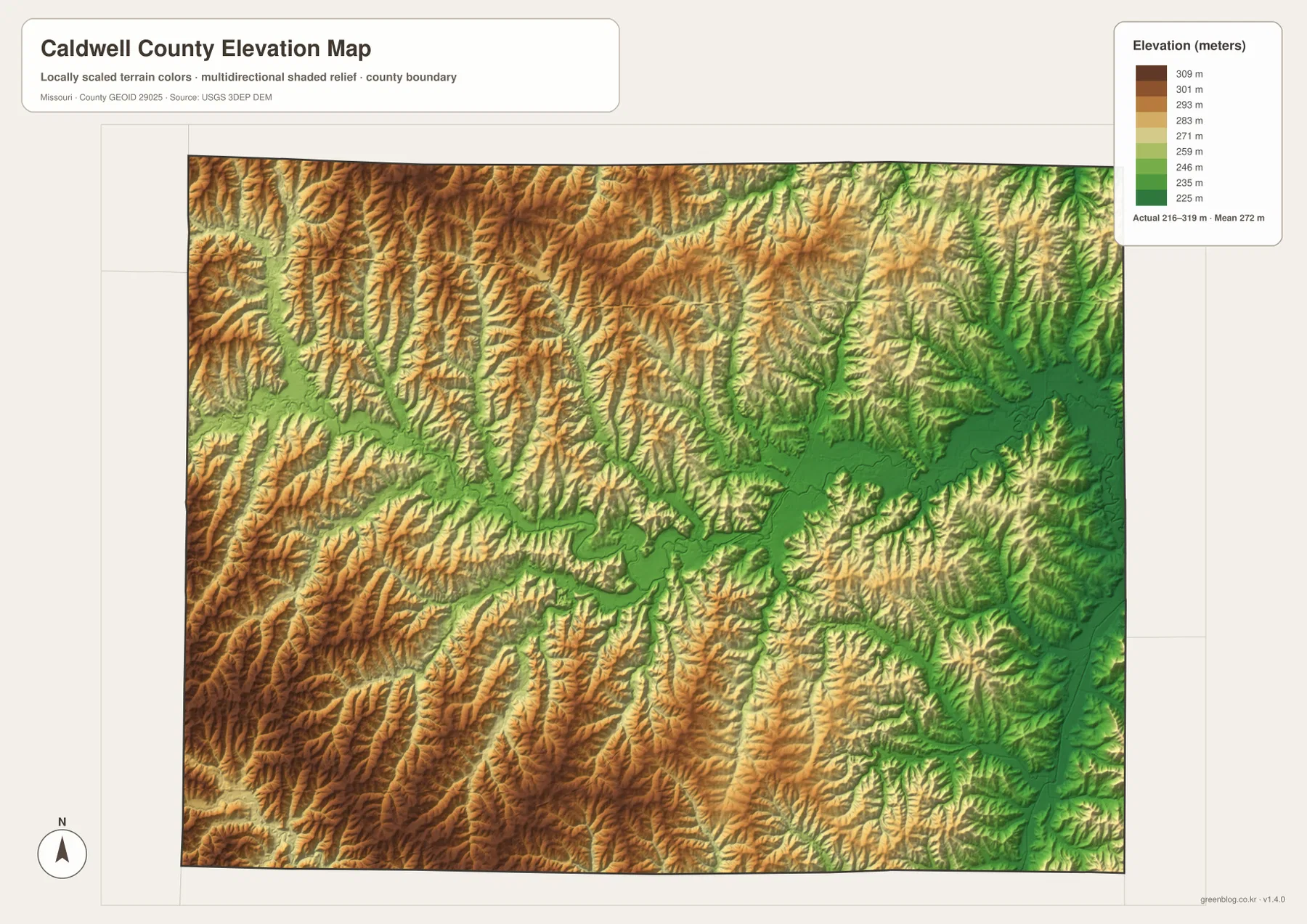
The terrain view also changes how the road network is interpreted. Route 13 may look like a straightforward north-south line between Hamilton and Kingston, but the shaded relief shows many small valley crossings around that corridor. Route 116 in the south likewise passes through a landscape broken by tributaries and the Crooked River drainage. These differences are useful for understanding the county’s physical setting even when the main purpose of the page is simply to locate towns and roads.
Choosing the Best View for Roads, Communities, Water, or Relief
For basic orientation, begin with the general county map. It puts Hamilton’s U.S. 36-Route 13 junction, Kingston’s central location, the southern Route 116 corridor, and Braymer in one frame. If the goal is to compare community distribution without extra road detail, the ranked city map is cleaner and quickly shows the separation among Kidder, Hamilton, Breckenridge, Kingston, Polo, and Braymer.
For physical geography, use the water and elevation maps together. The water map names Shoal Creek, Little Otter Creek, Tom Creek, Crooked River, and smaller tributaries; the elevation map explains why many of those channels follow green low corridors between higher ridges. The pairing is especially useful across the center and southwest, where multiple drainage systems cut through rolling uplands.
The original JPG files are 3638 by 2572 pixels each, providing more room to enlarge small creek labels, community names, and road numbers than the WebP images displayed in the article. They are suitable for general geographic reference, classroom materials, and print preparation. They should not replace current official sources for legal boundaries, parcels, flood zones, road closures, zoning, or precise elevation work.
A useful way to summarize Caldwell County is to pair Hamilton with Shoal Creek. Hamilton represents the northern transportation framework, while Shoal Creek provides the strongest central natural reference. Kingston, Braymer, Polo, the western ridges, and the Crooked River drainage fit around those two anchors, giving the county a clear human-geography and physical-geography structure without trying to force every detail onto one map.
Frequently Asked Questions
Why does Hamilton look more prominent than Kingston if Kingston is the county seat?
Town size and county-government status are different things. Hamilton ranks first on the supplied city map and is described by the county’s own history site as its largest town. Kingston is smaller in the city ranking but serves as the county-government center and has the long courthouse history. The road map reinforces that distinction: Hamilton sits at the U.S. 36-Route 13 junction, while Kingston lies farther south on Route 13.
Does the green low terrain on the elevation map show flood zones?
No. Green indicates relatively lower elevation within the locally scaled county map; it is not a FEMA flood-zone symbol. Shoal Creek and Crooked River valleys may appear in lower colors, but actual flood risk depends on hydrology, rainfall, channel conditions, levees, and official flood mapping. Use current FEMA and local sources for insurance, development, or safety decisions.
Can the 1-to-6 city ranking be treated as a current official population ranking?
The ranked city map is a convenient reference for the six selected communities and their relative placement. It is useful for comparing Hamilton, Braymer, Kidder, Breckenridge, Polo, and Kingston, but population totals can change as new estimates or censuses are released. For current official population figures or municipal status, check the U.S. Census Bureau and local-government sources.
Map File Information
The ZIP contains the original high-resolution JPG files for the county map, ranked city-distribution map, terrain-and-water map, and elevation map shown in this article. The originals are larger than the on-page WebP images and are suitable for closer viewing and print preparation.
- Included Files: 4 maps
- File Type: JPG
Related Maps
Sources and References
- Caldwell County – Hamilton History: county background describing Hamilton and its place in local history.
- Caldwell County – Kingston History: county background on Kingston and the courthouse history.
- U.S. Census Bureau TIGER/Line Shapefiles: official geographic boundary data.
- USGS National Hydrography: official hydrography information for streams, lakes, and related water features.
- USGS 3D Elevation Program: official elevation and terrain-surface data.
Green Map creates custom-edited map images using open geographic data sources such as geoBoundaries, Natural Earth, OpenStreetMap, and government open data. These maps are edited visual materials, not raw data files, and are provided for education, documents, presentations, and graphic reference.