Bollinger County sits in southeastern Missouri, where an upland landscape in the north and west gives way to lower country toward the Castor River and the county’s southern edge. Marble Hill provides the clearest reference point for reading the local road network, while Sedgewickville, Glen Allen, and Zalma help orient different parts of the county. The map files shown on this page can also be downloaded as original high-resolution JPGs for closer viewing or print use.
The four supplied maps emphasize different parts of the same geography rather than repeating one design. The county map combines boundaries, places, roads, and streams. The city-connections map simplifies the relationship between Marble Hill, Glen Allen, and Sedgewickville. The terrain-and-water map brings the Whitewater and Castor River systems forward, while the elevation map makes the contrast between the higher northwest and the lower south and southeast especially easy to see.
Missouri records show that Bollinger County was organized in 1851 and named for pioneer settler and legislator George F. Bollinger. Marble Hill is the county seat. Those facts provide useful background, but the strongest local story on the maps is physical: roads bend through short ridges and valleys, small streams branch across nearly every part of the county, and the elevation colors change markedly between the rugged northwest and the low southern margin.
Table of Contents
Roads and boundaries radiating from Marble Hill
The general county map is the best starting point because it places the road system inside the full Bollinger County outline. Marble Hill lies slightly south of the county’s midpoint and works as the main orientation point. Route 51 runs down from the north toward the Marble Hill area, while Route 34 approaches from the west through the southern half of the county. In the northeast, Route 72 passes near Sedgewickville before continuing toward the eastern boundary, and Route 91 appears along the southeastern side.
The county outline is also worth noticing. The northern and eastern edges are comparatively regular, but the southern and southwestern sides include several step-like changes that give Bollinger County a distinctive shape. Perry County lies to the north, Cape Girardeau County to the east, Scott County toward the southeast, Stoddard County to the south, Wayne County to the west and southwest, and Madison County to the northwest. Labels outside the boundary, including Fredericktown and Advance, provide additional reference points for readers who know the wider region.
Roads become more winding away from the main numbered routes. The map shows many smaller roads crossing short tributaries or following the spaces between ridges. In the central and northern parts of the county, road lines repeatedly change direction as they pass through a dense network of narrow valleys. That pattern becomes easier to understand when the same area is compared with the terrain-and-water map, where the ridges and drainage lines are much more visible.
South of Marble Hill, the road pattern begins to open into lower terrain. Zalma appears in the southern part of the county, with multiple local roads continuing toward the Castor River country and the irregular southern boundary. The general map is therefore more than a road reference: it is useful for seeing how the settlements, major routes, county edges, and fine stream network occupy the same space.
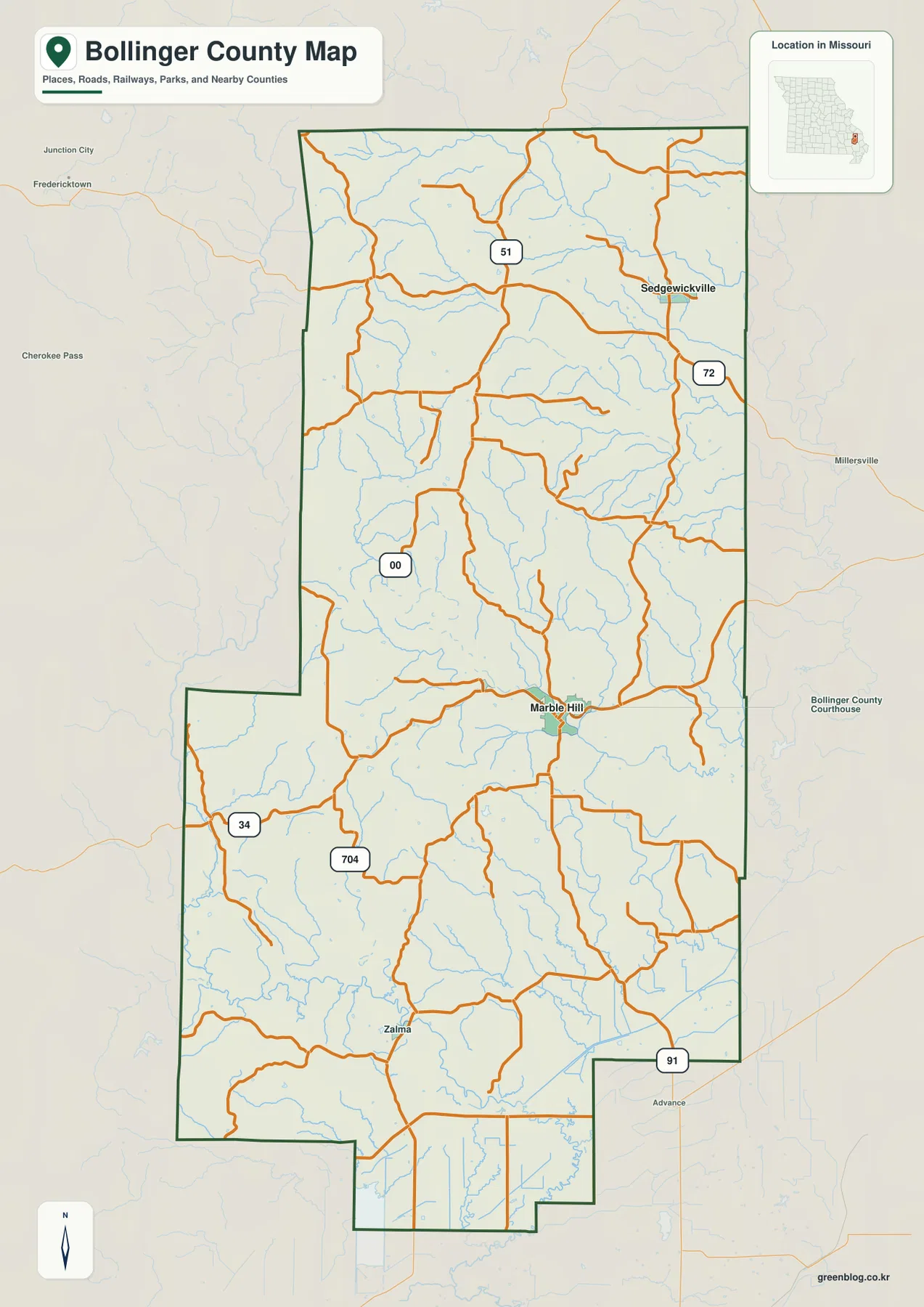
Marble Hill is not at the exact geometric center of the county, yet it is the most practical anchor for the map because the county seat and several major routes come together there. Starting at Marble Hill makes it easier to judge the position of Sedgewickville to the northeast and Zalma to the south. It also helps separate the higher, more dissected northwestern half from the broader low country farther south.
Marble Hill, Glen Allen, and Sedgewickville at different scales
The city-connections map deliberately reduces the amount of detail so the relative position of three communities stands out. Marble Hill is used as the hub. Glen Allen sits close to it on the northwestern side, while Sedgewickville is much farther away in the northeast. That simple arrangement makes the settlement pattern easier to grasp before returning to the more detailed road map.
The labeled connector distances are straight-line distances, not driving distances. Glen Allen is shown about 3 miles from Marble Hill, while Sedgewickville is shown about 15 miles away. These figures are useful for comparing relative separation, but a vehicle route can be longer because roads bend around ridges, follow valleys, and cross streams. Anyone planning a drive should use the county road map or an official transportation map rather than treating the connector line as a route.
The short Marble Hill–Glen Allen separation highlights how closely the central communities are grouped. Roads and tributaries converge within a compact area, so the central part of the county reads as a connected cluster rather than a single isolated town. Sedgewickville has a different setting. It lies closer to the northeastern boundary and Route 72, giving it a stronger relationship to the eastern side of the county and the direction of Cape Girardeau County.
The surrounding county labels also help with orientation. Perry County is above the map, Cape Girardeau County is to the east, Scott County lies toward the southeast, and Madison and Wayne counties occupy the western side. This wider context is useful when a place name is familiar but the county boundary is not. The city map shows where the communities sit in that broader frame without making the reader trace every local road first.
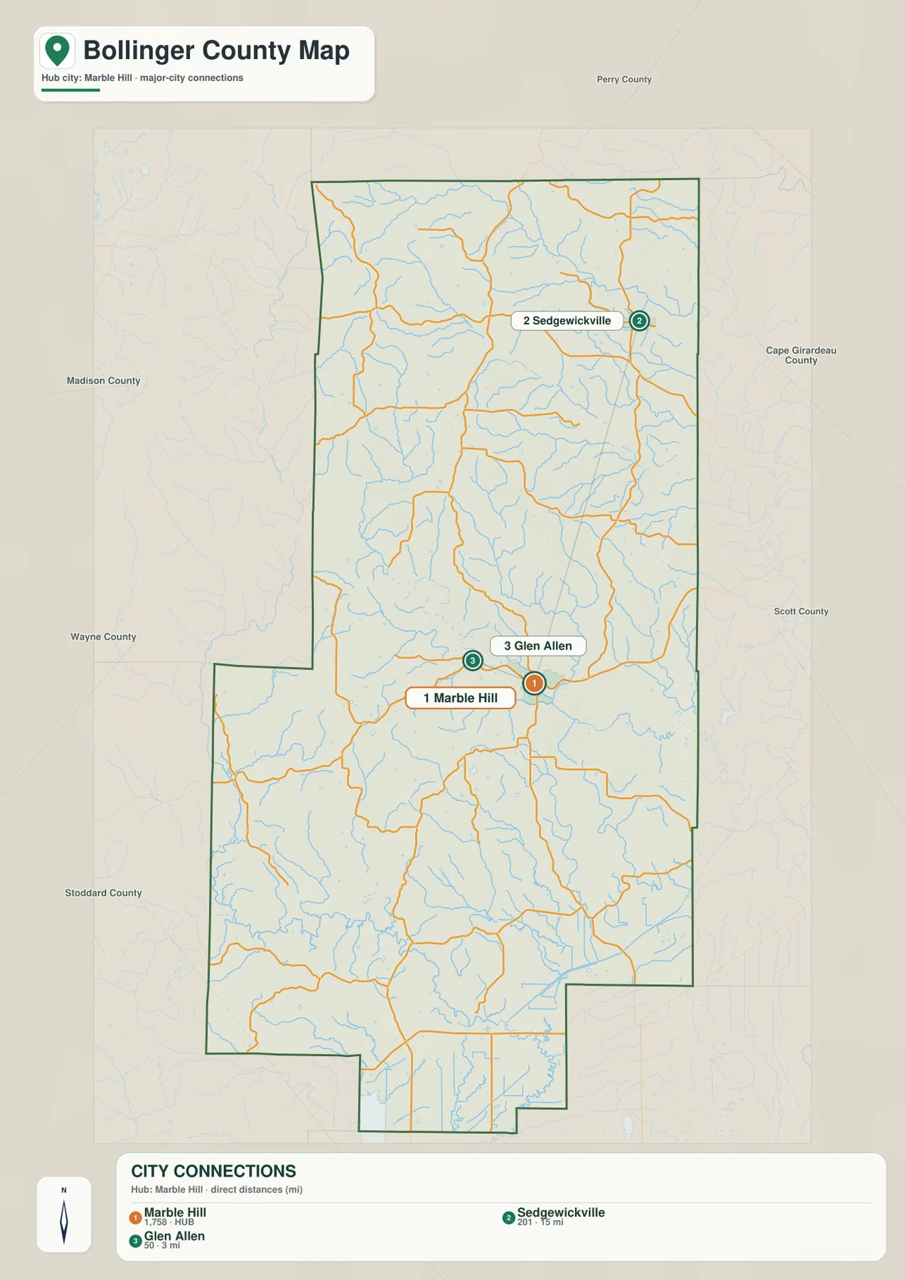
The word “hub” on this map should be read as a cartographic reference point rather than a ranking of economic size or traffic volume. Marble Hill is simply the place from which the connector distances are drawn. For a quick presentation, that makes the map clean and useful; for turn-by-turn travel, the detailed county map and Missouri Department of Transportation resources remain the better choice.
Whitewater streams, Crooked Creek, and the Castor River valleys
The terrain-and-water map reveals how strongly streams shape Bollinger County. In the north and northeast, the Whitewater River is one of the most prominent labeled waterways. Little Whitewater Creek crosses the upper half of the county below it, while Crooked Creek occupies a large central-western drainage. Farther east, Hurricane Creek and smaller tributaries run through closely spaced valleys. Relief shading makes the ridges between these streams visible even where no road is labeled.
The southern half has a different visual emphasis. The Castor River becomes the major named waterway in the southwest and south, with smaller tributaries feeding into the lower country. Dry Creek and Malone Creek appear on the southeastern side, while additional branches enter from the central uplands. Rather than one simple drainage line, the map shows a tree-like network in which many short creeks descend from ridges toward larger streams.
Crooked Creek and Little Crooked Creek are especially useful for understanding the Marble Hill area. On the general map, several roads in the central part of the county seem to turn repeatedly. When the same area is viewed with terrain relief, those turns make more sense because roads often stay within valleys, cross a creek at a workable point, or curve around steeper ground. The map does not need to show every contour line for the relationship between roads and valleys to become clear.
The Missouri Department of Conservation describes Castor River Conservation Area west of Marble Hill, reached from Highway 34, as a largely forested landscape with streams and small springs. That official description fits the southwestern part of the terrain map, where the Castor River and broken upland relief appear together. The map here is a reference for water and terrain location, however; it is not a flood-hazard map, parcel boundary map, or navigation chart.
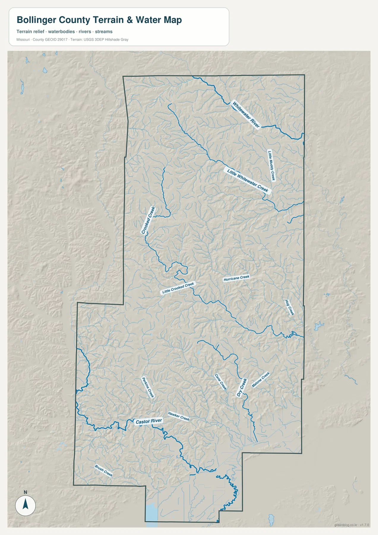
A practical way to read this map is to begin with the larger names. Whitewater River and Little Whitewater Creek organize the northern portion, Crooked Creek and Hurricane Creek help explain the center, and Castor River anchors the south. Once those larger features are located, the many smaller blue lines show how heavily dissected the uplands are. This is why the county can contain short straight-line distances between communities while still requiring winding road travel.
Higher northwest ridges and lower southern country
The elevation map gives the clearest overview of height differences. Its legend shows an actual elevation range of about 94 to 306 meters, with a mean near 180 meters. Browns and darker tan shades mark higher ground, while greens mark lower ground. The strongest concentration of high terrain lies in the northwest and north, whereas broad green areas spread across the southern and southeastern parts of Bollinger County.
The northwest is not a single flat high plateau. Instead, short ridges and narrow valleys repeat closely across the map. Green fingers extend into the higher colors where streams cut down through the uplands. Similar but less extensive high ground continues across parts of the north and center. The Whitewater drainage creates conspicuous low corridors through that higher terrain, which helps explain the branched valley pattern visible on the water map.
Near the Marble Hill area, high and low terrain are interwoven. Valleys connected with Crooked Creek and Little Crooked Creek show as lower green corridors, while the intervening ridges remain yellow, tan, or brown. Comparing the elevation and water maps side by side makes the central road pattern easier to interpret. Roads frequently follow the lower breaks in the terrain or cross between valleys where the ridge system allows a practical connection.
The southern end changes character. Large green areas dominate around the Castor River side of the county and continue toward the southeast, showing a broader area of low elevation than in the north. The Missouri Department of Conservation describes the Greenbrier Unit in southeastern Bollinger County as lowland swamp between the Ozark Plateau and Crowleys Ridge, influenced by runoff and overflow from the Castor River. That local description is consistent with the low colors on the southern portion of this county-scale elevation map.
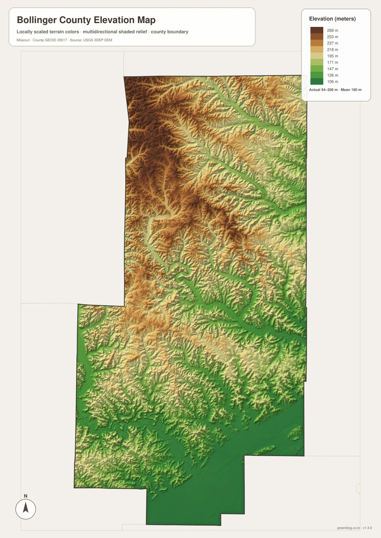
This elevation layer is intended for broad geographic interpretation. It is useful for seeing where ridges, valleys, and lowlands dominate, but it should not be treated as a survey-grade measurement for a property, road project, or construction site. Readers who need precise elevations should consult original USGS elevation data or professional field measurements for the exact location in question.
Choosing the most useful map for a specific question
For road and boundary orientation, the general county map should usually come first. It keeps Marble Hill, Sedgewickville, Zalma, the county outline, and the numbered routes in one view. That makes it useful for locating an unfamiliar community, comparing the direction of neighboring counties, or checking which major route serves a part of the county. It also provides enough stream detail to show that the road network is moving through a strongly dissected landscape.
For settlement relationships, the city-connections map is faster because it strips away much of that detail. The contrast between Glen Allen at roughly 3 straight-line miles from Marble Hill and Sedgewickville at roughly 15 miles is immediately visible. The map is most useful when the reader understands that the connector is not a road. Its job is to compare position and separation, not to replace a driving map.
For natural features, the terrain-and-water map carries the most information. Whitewater River, Little Whitewater Creek, Crooked Creek, Castor River, Hurricane Creek, and several other named streams are visible against shaded relief. It is a strong choice for explaining why the county has so many narrow valleys and why roads frequently curve. It should be paired with official flood information if the question involves inundation or flood risk.
For height differences, the elevation map is the clearest. The color scale quickly separates the higher northwest from the lower south and southeast, and the water map can then explain which low corridors are occupied by major streams. Used together, the maps show a county that changes from rugged upland ridges to lower river country rather than a uniform surface. That contrast is one of the most useful geographic themes for understanding Bollinger County.
The original JPG files are particularly helpful when small tributaries, road labels, or local place names need to be enlarged. The on-page WebP images are optimized for browsing, while the downloadable files preserve the larger 2572 × 3638 pixel originals. For a presentation or print handout, choose the map that answers the main question instead of placing all layers on one page and making the information harder to read.
Frequently Asked Questions
Which map is best for locating Marble Hill and the major highways?
Use the general county map when the main goal is to locate Marble Hill with Routes 34, 51, 72, and 91, county boundaries, nearby communities, and surrounding counties in the same view. The city-connections map is a useful companion if you also want a simplified comparison of Marble Hill with Glen Allen and Sedgewickville.
Why does southeastern Bollinger County appear lower on the elevation map?
The elevation colors show more high ridges in the northwest and broader low ground toward the south and southeast. The Castor River and many tributaries occupy lower corridors, and southeastern Bollinger County includes lowland terrain associated with the transition toward Crowleys Ridge. The map legend spans roughly 94 to 306 meters, but the surface is generalized and should not be used as a precise survey elevation for an individual site.
Are the 3-mile and 15-mile labels on the city map driving distances?
No. They are straight-line distances from the Marble Hill hub. Glen Allen is shown at about 3 miles and Sedgewickville at about 15 miles in direct distance. Actual road mileage can be longer because roads bend through ridges and valleys. Use the detailed county road map or Missouri Department of Transportation resources for route planning.
Map File Information
The ZIP contains the original high-resolution JPG versions of the county map, city-connections map, terrain-and-water map, and elevation map shown on this page. These originals are larger than the WebP images used in the article and are better suited to close inspection or print layouts.
- Included Files: 4 maps
- File Type: JPG
Related Maps
Sources and references
- Missouri Secretary of State – Origins of Missouri Counties for the county’s organization date and namesake.
- Missouri Official Manual 2025–2026 – Counties for the official county-seat listing.
- Missouri Department of Transportation – County Maps for official county road mapping.
- Missouri Department of Conservation – Castor River Conservation Area for local forest, stream, and access context west of Marble Hill.
- USGS National Hydrography for authoritative surface-water reference data.
- USGS 3D Elevation Program for authoritative elevation data.
Green Map creates custom-edited map images using open geographic data sources such as geoBoundaries, Natural Earth, OpenStreetMap, and government open data. These maps are edited visual materials, not raw data files, and are provided for education, documents, presentations, and graphic reference.