Adair County lies in northeast Missouri, with Kirksville serving as the county seat and the clear center of the supplied maps. U.S. 63 runs north–south through Kirksville, while Missouri Route 6 crosses the county from the Novinger side toward the east. Novinger sits northwest of the hub city, Brashear lies to the east, and Millard and Gibbs occupy the southern half. The four high-resolution JPG map files shown on this page can be downloaded together from the ZIP box below.
The road view is only part of the story. Adair County is cut by many narrow valleys and ridges, with the Chariton River system on the west and central side and branches of the South Fabius River on the east. Forest Lake, Thousand Hills Lake, Spring Lake, and several smaller lakes sit among those uplands. The elevation legend reports an actual range of about 216 to 321 meters with a mean near 273 meters, so the county’s relief comes from frequent ridge-to-valley changes rather than a single large mountain or escarpment.
Table of Contents
Kirksville is the road hub where U.S. 63 meets Route 6
Kirksville sits close to the middle of Adair County and is the most prominent settlement on the general map. U.S. 63 enters from the north near the Greentop direction, passes through Kirksville, and continues south. Missouri Route 6 approaches from the Novinger side and crosses the central part of the county through Kirksville before continuing east. Starting with those two routes makes it much easier to place the county’s smaller towns and rural roads.
Novinger lies northwest of Kirksville along the Route 6 corridor, with Connelsville farther north. Missouri Route 157 is marked west of Kirksville, while Routes 149 and 11 appear farther southwest. Roads on this side bend through a landscape of stream valleys and ridges rather than following one uninterrupted grid. That road shape becomes easier to understand after comparing the general map with the water and elevation views.
Brashear provides the main eastern town reference. South of Kirksville, Millard is relatively close to the central highway corridor, while Gibbs sits farther southeast. U.S. 63 continues through the southern half, and Missouri Route 3 is marked near the south-central edge. The settlements are separated by broad rural areas, so the major highways and state routes stand out as the main links between them.
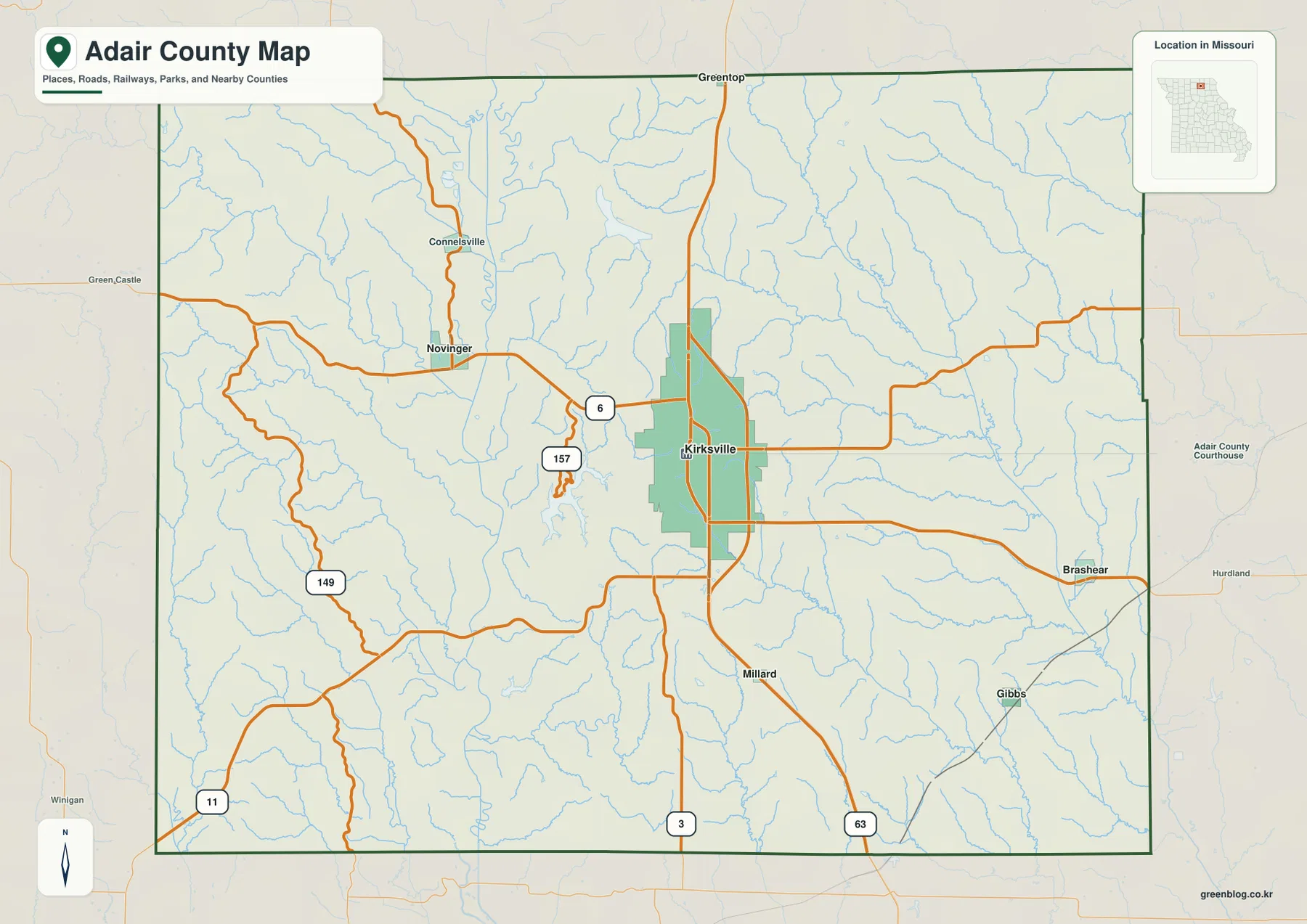
The county boundary is fairly regular, but the landscape inside it is not. West of Kirksville and around Novinger, roads bend around the same valleys that appear as blue stream lines on the water map. Small tributaries also cut the eastern countryside around Brashear. The result is a county where the settlement pattern is simple at first glance but the underlying terrain is much more dissected.
Adair County’s official government site describes the county as being in northeast Missouri, covering about 569 square miles, with Kirksville as the county seat. That scale helps explain the amount of open space between the smaller communities on the map. The general map is useful for county orientation and major routes, while current road work, closures, or turn-by-turn driving should be checked with up-to-date transportation sources.
Straight-line distances from Kirksville show the spacing of nearby towns
The city-connections map uses Kirksville as its hub and lists four nearby communities. Its CITY CONNECTIONS panel shows Kirksville at 17,563, Novinger at 423, Brashear at 182, Millard at 106, and Gibbs at 62. These are the reference values printed on the supplied map and are best used for comparing the places shown there; the latest official population figures should be checked in current Census data.
The distance labels are direct straight-line distances rather than road mileage. Novinger is shown about 8 miles from Kirksville, Brashear about 11 miles, Millard about 6 miles, and Gibbs about 11 miles. A driving route can be longer because roads follow the terrain and do not always run directly between the two points.
The four connections also summarize the county’s settlement pattern. Novinger is northwest of Kirksville and aligns with Route 6, Brashear is to the east, Millard is the nearest highlighted community to the south, and Gibbs lies farther southeast. None of these points forms a dense suburban chain; each sits within a separate rural setting divided by streams and ridges.
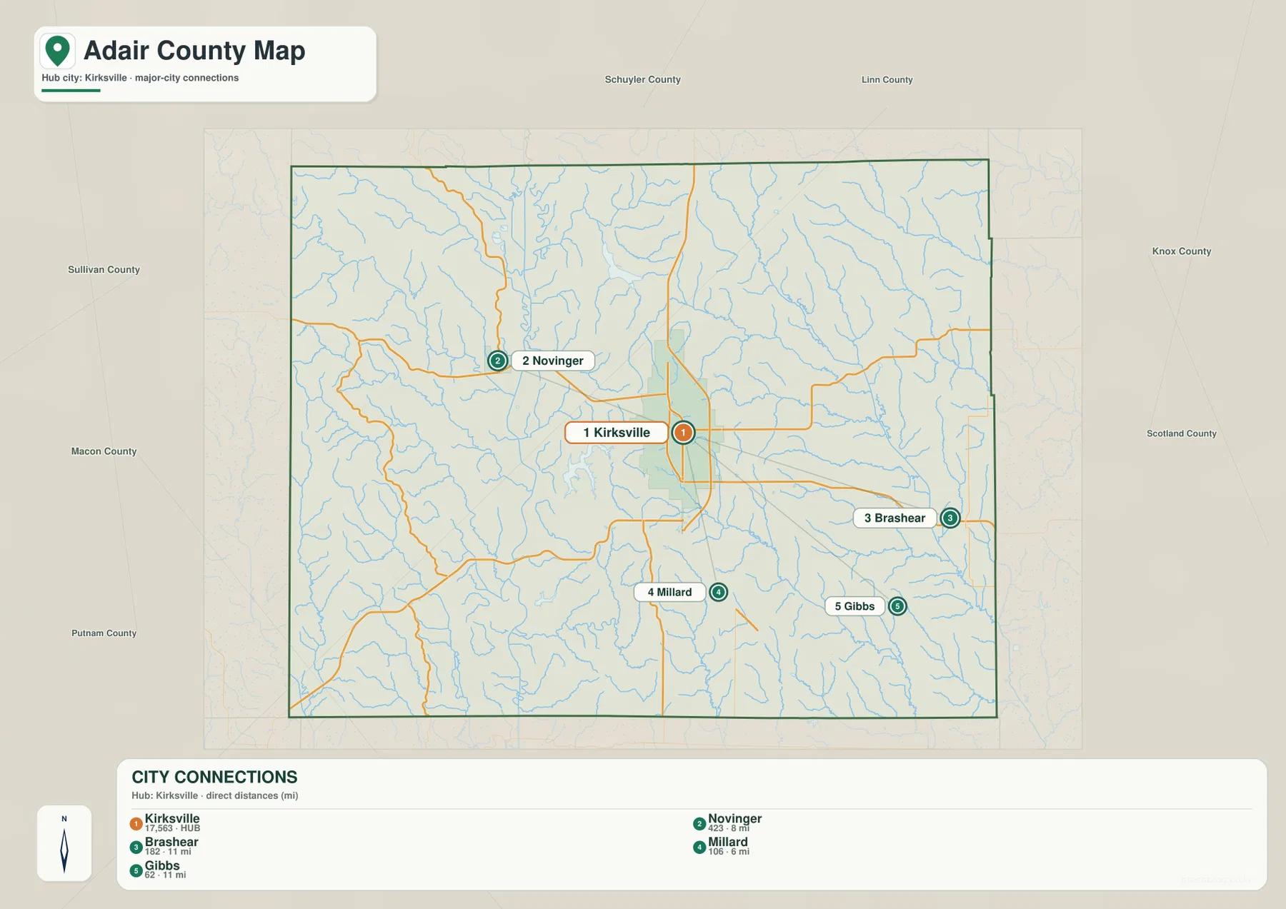
Because the city map strips away most local roads, its main value is comparison. It makes the central position of Kirksville obvious and shows how the smaller communities fan out in different directions. Returning to the general map after viewing these connections reveals which highways and rural roads actually serve each destination.
Kirksville is also visually much larger than the other highlighted places. The general map shows a broad built-up area around the hub, while Novinger, Brashear, Millard, and Gibbs appear as much smaller settlements separated by open land. That difference in scale is one of the clearest reasons to use Kirksville as the starting point when reading Adair County.
Chariton and South Fabius branches divide the county into separate valleys
On the western side, the Chariton River is the strongest named water feature. The Old Chariton River is labeled in the north, and the main Chariton channel continues south through a low valley. Numerous small tributaries branch into that corridor from surrounding ridges. The elevation map echoes the same shape with a long green lowland cutting through higher terrain.
The eastern half belongs to a different set of streams. The North Fork South Fabius River and South Fork South Fabius River run through long eastern valleys, while the North Fork Salt River occupies another drainage corridor between them and the county center. Bear Creek appears farther south, and the East Fork Little Chariton River is labeled in the southeastern interior. Compared with the west, the east contains fewer prominent lakes but many branching streams.
Several lakes cluster west and southwest of Kirksville. Lake Elsie and Scobee Lake appear closer to the northern Chariton corridor. Forest Lake, Thousand Hills Lake, and Ownbey Lake sit among the ridges farther south, and Spring Lake lies closer to the lower Chariton valley. Their positions make the Kirksville west side one of the easiest places to compare water features with the surrounding relief.

Missouri State Parks describes Forest Lake as the centerpiece of Thousand Hills State Park west of Kirksville. The official park page notes fishing, swimming, boating, hiking, and mountain biking opportunities around the lake and surrounding park. On the county-scale map, Forest Lake and the neighboring lakes help mark the transition from the Kirksville area into a more strongly ridged landscape.
This is a water-location reference, not a flood-risk, depth, water-quality, legal-boundary, or navigation product. Conditions on streams and lakes can change, so property and safety decisions require current specialized sources. For ordinary orientation, start with the Chariton River in the west and the two South Fabius branches in the east, then use the lakes near Kirksville to tie the water network back to familiar roads and settlements.
A 216–321 meter range creates repeated ridge-and-valley relief
The elevation legend reports an actual Adair County range of roughly 216 to 321 meters and a mean near 273 meters. The lowest dark-green areas follow major valleys, while yellow, tan, and brown mark higher ridges between them. The total vertical difference is only a little over 100 meters, but that relief repeats over short distances across much of the county, creating a highly textured surface.
The western side shows some of the strongest contrasts. High ridges near the county edge stand beside the lower Chariton River corridor, and another long low valley runs through the west-central area. Small tributaries cut back into the surrounding high ground. This combination helps explain why roads near Novinger and west of Kirksville often curve rather than follow long straight lines.
Central and eastern Adair County also contain broad higher zones broken by narrow green valleys. The South Fabius branches and North Fork Salt River occupy some of the longest low corridors in the east. Around Brashear and the southeast, many smaller streams dissect the ridges, so the terrain appears much more complex on the shaded elevation surface than it does on the road map.
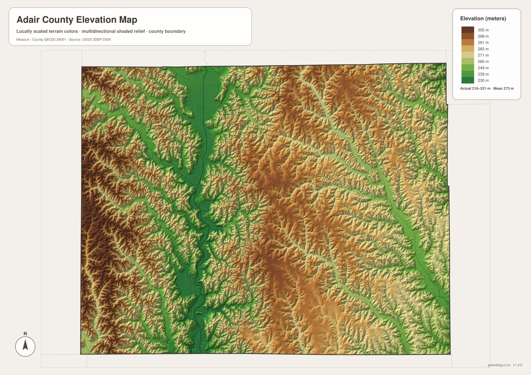
The elevation surface is generalized for county-scale comparison. It is not survey-grade information for a parcel, building site, road slope, drainage structure, or engineering project. Those uses require source elevation data and field verification. For general map reading, the image is most useful for explaining why the Chariton and Fabius river valleys appear low and why higher ridges fill the land between them.
Putting the water and elevation views side by side gives the clearest picture of Adair County. Major streams occupy the lowest green corridors, smaller tributaries cut into the surrounding uplands, and Kirksville sits near the center of this network. U.S. 63 and Route 6 cross those ridges and valleys to connect the hub city with Novinger, Brashear, Millard, and the rest of northeast Missouri.
Connecting Kirksville roads with the county’s river valleys
Begin with Kirksville, U.S. 63, and Route 6 on the general map. Follow Route 6 northwest toward Novinger and east from the hub, then use U.S. 63 to orient the north–south direction. Add Brashear on the east, Millard to the south, and Gibbs in the southeast. Once those positions are fixed, the county’s basic settlement pattern becomes easy to remember.
Next, trace the Chariton River south through the western half and compare it with the North and South Forks of the South Fabius River on the east. Forest Lake and Thousand Hills Lake provide useful water landmarks west of Kirksville. On the elevation view, these same river corridors become green lowlands between tan and brown ridges, revealing how water and relief fit together.
Use the general map for highways, towns, and county orientation. The city-connections view is best for comparing the direct distance from Kirksville to four nearby communities. The water map isolates rivers, creeks, and lakes, while the elevation map shows the 216–321 meter relief. Selecting the view that matches the task keeps the county easier to understand in print, class materials, presentations, or personal reference.
Frequently Asked Questions
Are the distances from Kirksville driving distances?
No. The city-connections map labels straight-line distances: about 8 miles to Novinger, 11 miles to Brashear, 6 miles to Millard, and 11 miles to Gibbs. Driving mileage can be longer because roads bend around the terrain and do not always follow the direct line.
Which rivers and lakes are the easiest landmarks in Adair County?
The Chariton River and Old Chariton River are prominent on the western side, while the North and South Forks of the South Fabius River stand out in the east. Forest Lake, Thousand Hills Lake, Ownbey Lake, and Spring Lake are useful water landmarks west and southwest of Kirksville.
What does the Adair County elevation map show?
The legend gives an actual elevation range of about 216 to 321 meters and a mean near 273 meters. Major river valleys appear as low green corridors, while the land between them rises into yellow and brown ridges. The image is for broad comparison rather than survey or engineering measurements.
Map File Information
The ZIP contains the high-resolution JPG originals of the Adair County general map, city-connections map, water map, and elevation map shown on this page.
- Included Files: 4 high-resolution JPG maps
Related Maps
Sources and references
- Adair County Missouri Government — official county location, county-seat, and general county information
- Missouri State Parks — Thousand Hills State Park — Forest Lake and official park information
- U.S. Census Bureau TIGER/Line Shapefiles — county boundaries and geographic reference data
- USGS National Hydrography — rivers, streams, and water features
- USGS 3D Elevation Program — elevation and terrain reference data
Green Map creates custom-edited map images using open geographic data sources such as geoBoundaries, Natural Earth, OpenStreetMap, and government open data. These maps are edited visual materials, not raw data files, and are provided for education, documents, presentations, and graphic reference.