Wadena County lies in the north-central part of Minnesota’s interior, where a small group of towns is spread between higher western ground and lower river country toward the east and southeast. Wadena sits near the western edge and provides the easiest road reference because U.S. 10 and U.S. 71 meet there. U.S. 71 runs north through Sebeka and Menahga, while U.S. 10 heads southeast through Verndale and Aldrich toward Staples. The maps on this page add rivers, lakes, and elevation to that road framework, and the high-resolution JPG originals can be downloaded together from the file box below. High-resolution map files are available for download in the section below.
The county is not dominated by one large lake or one metropolitan center. Instead, its geography becomes clearer through several smaller features: the Leaf and Redeye rivers in the central and southern sections, the Blueberry and Crow Wing systems in the north, scattered lakes, and a broad elevation change from the west and northwest toward the southeast. Looking at these pieces together gives Wadena County a more recognizable shape than a simple county outline alone.
Table of Contents
U.S. 10 and U.S. 71 make Wadena the main road reference
Wadena is close to the county’s western boundary, but its highway connections make it a practical starting point for reading the entire map. U.S. 71 leaves Wadena to the north and continues through Sebeka before reaching Menahga. U.S. 10 takes a very different course, running southeast past Verndale and Aldrich toward Staples. That fork creates two distinct strings of towns, so a visitor who first finds Wadena can quickly decide whether a place belongs to the northern U.S. 71 corridor or the southeastern U.S. 10 corridor.
Menahga is near the meeting of U.S. 71 and Minnesota Highway 87. Farther south, Sebeka occupies the same north-south highway line, while Minnesota Highway 227 extends eastward from the U.S. 71 area toward Nimrod. Nimrod is much smaller than the other labeled communities, yet it is an important visual anchor for the eastern interior because it sits away from the two major highway chains. The Minnesota Department of Transportation also lists Minnesota Highway 29 among Wadena County’s state routes, reinforcing Wadena’s role as a local road junction.
The southern map has a different geometry. U.S. 10 crosses from the Wadena area toward Verndale, Aldrich, and the county’s southeastern corner near Staples rather than continuing straight east. Several county boundaries are close to these towns: Otter Tail and Becker counties are on the western side, Hubbard County is to the north, Cass County lies to the east, and Todd County borders the southwest and southern side. Because Wadena and Staples are both near county edges, the boundary line is useful when distinguishing the county location from the larger city or road network beyond it.
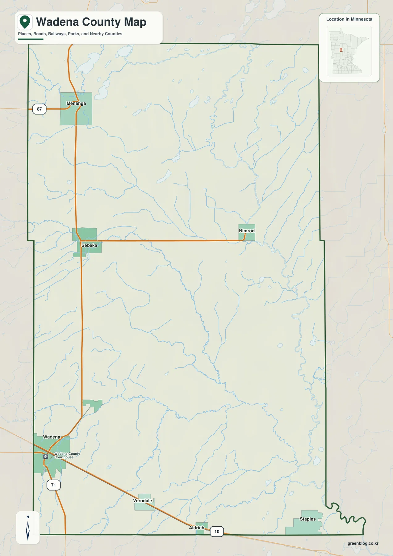
This general map is meant for county orientation rather than parcel, legal-boundary, or live navigation work. Highway construction and traffic conditions can change, and exact property limits require current official records. For ordinary map reading, the strongest use is to understand where the principal towns sit relative to U.S. 10, U.S. 71, Minnesota 87 and 227, and the surrounding counties.
Six labeled cities split between the northern and southeastern corridors
The city map emphasizes six communities: Wadena, Staples, Menahga, Sebeka, Verndale, and Nimrod. Its reference ranking lists Wadena at 4,419, Staples at 2,269, Menahga at 1,343, Sebeka at 725, Verndale at 452, and Nimrod at 118. Those values are useful for comparing the relative scale used by the map, but they should not be treated as a replacement for current official population estimates. The more important geographic lesson is that the six places form several separate clusters rather than one continuous urban strip.
Wadena stands apart on the west side, where the two major U.S. highways meet. Menahga and Sebeka form a northern pair along U.S. 71, and their alignment is easy to remember because both are tied to the same north-south route. Verndale and Staples belong to the U.S. 10 direction instead, with Verndale in the south-central part of the county and Staples close to the southeastern edge. Nimrod sits east of the U.S. 71 corridor, separated from the larger highway towns by a broad rural interior.
That arrangement also explains why Wadena County does not have a single geographic center of activity on the map. A trip from Wadena to Menahga follows a mostly northward highway line, while a trip from Wadena toward Staples turns southeast and crosses a different part of the county. Sebeka acts as a middle reference in the northern half, and Nimrod becomes more useful when the map discussion shifts to the Crow Wing River side. The city map is therefore most helpful when it is used to establish the town pattern before moving to water or elevation.
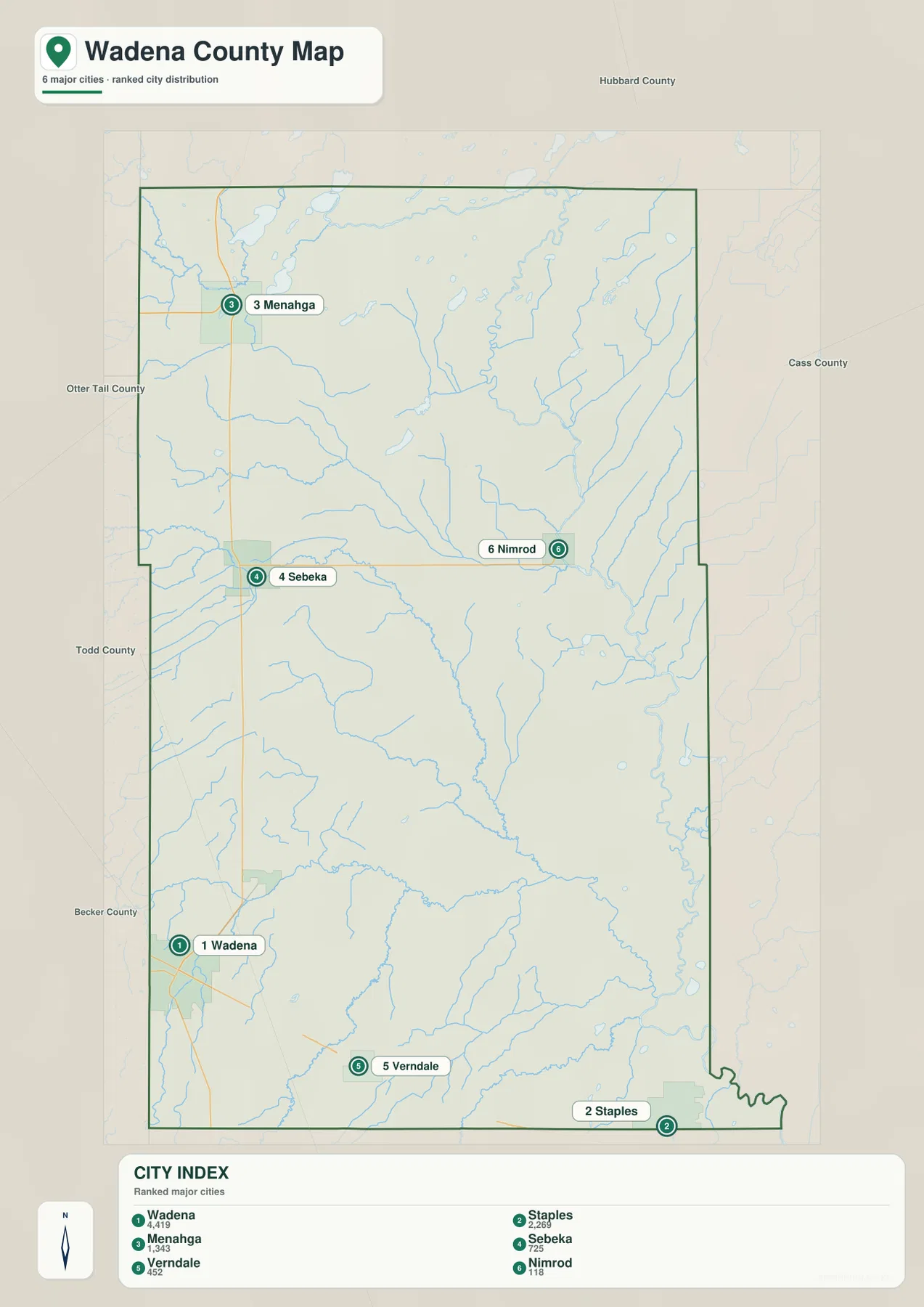
The ranking symbols are deliberately simple, so they should not be used to infer commuting patterns, service areas, or economic influence. Between these communities are broad rural areas crossed by rivers and smaller roads. After locating a town, the general map and the water map provide the additional context needed to see what lies between it and the next community.
Leaf River and Redeye River organize the central and southern drainage
The water map changes the way Wadena County looks because many features that are secondary on the road map become prominent. Redeye River runs through the central part of the county and continues south toward the Leaf River system. Leaf River crosses the southern section, while Wing River approaches from the southwest and Partridge River appears in the southeast. Together they create a network of low corridors that is especially important for understanding the southern half of the county.
North of that system, Cat River bends across the middle of the county. The upper part of the map contains a different collection of names: Blueberry River in the northwest, Shell River farther east, and Crow Wing River in the northeast. Blueberry Lake, Stocking Lake, and Lower Twin Lake are clustered toward the northwestern side, while Finn Lake and Rice Lake provide smaller reference points farther east and south. The concentration of small lakes in the north contrasts with the longer river courses that dominate the central and southern map.
The river pattern also gives the towns more context. Menahga and Sebeka are closer to the northern lake and Cat River country, while Wadena and the U.S. 10 corridor lead toward the Redeye and Leaf river systems. Nimrod lies on the eastern side where the Crow Wing drainage and numerous tributaries become visually dense. This difference is one of the strongest county-specific features: the northern portion has several named lakes and short tributaries, whereas the southern portion is more clearly organized around the Leaf River and the streams that feed it.
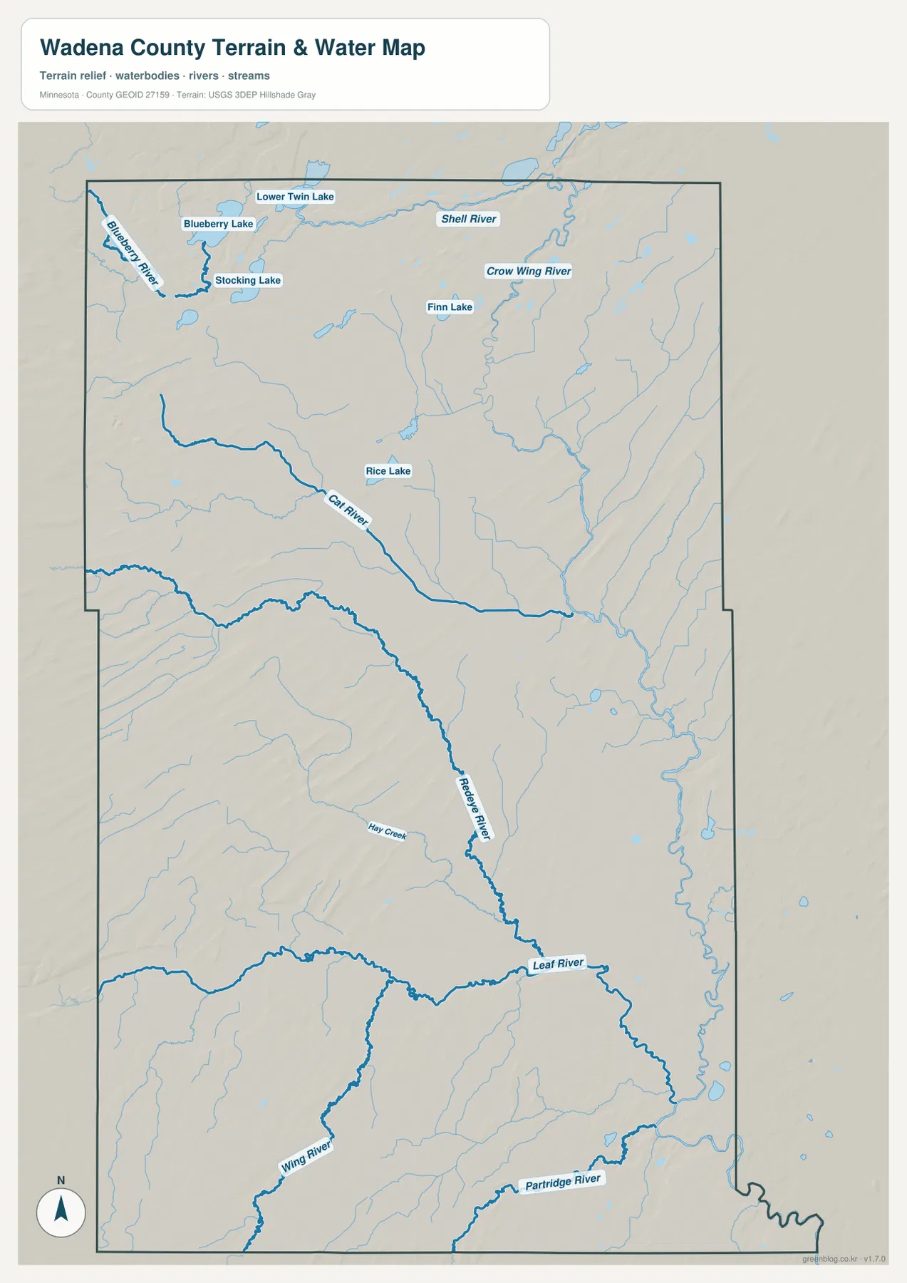
This map is a geographic water reference, not a flood-risk, boating, water-depth, or water-quality product. River conditions and flood potential vary with season and weather, so safety-sensitive decisions require current agency information. For county orientation, the image works best for matching towns and roads with nearby rivers, lakes, and tributary corridors.
A 373–465 meter range slopes from western high ground toward the southeast
The elevation legend gives an actual county range of about 373 to 465 meters, with a mean near 411 meters. Higher brown terrain is concentrated across much of the west and northwest, while greens become more common toward the east and southeast. The numerical difference is less than 100 meters, but the shaded relief exposes many narrow ridges and drainage cuts that make the surface more varied than a plain color ramp would suggest.
Western Wadena County contains repeated elongated ridges, especially in the northwestern and west-central areas. Moving eastward, the colors generally become lighter and then greener, although the transition is interrupted by many stream valleys. The southeast is the broadest low-looking part of the image, and the Leaf and Partridge river corridors fit naturally into that lower terrain. In the northeast, branching tributaries also cut lower channels through otherwise moderate ground.
Comparing elevation with the water map makes the pattern easier to interpret. Redeye River, Leaf River, and Crow Wing River occupy lower corridors, while the long ridges between them appear as higher bands. This does not mean every road or settlement sits at a single predictable height, but it explains the county-wide contrast between the higher western side and the lower southeastern drainage country. The relief is particularly useful for understanding why streams branch so heavily in the east and why the western map has a stronger sequence of ridges.
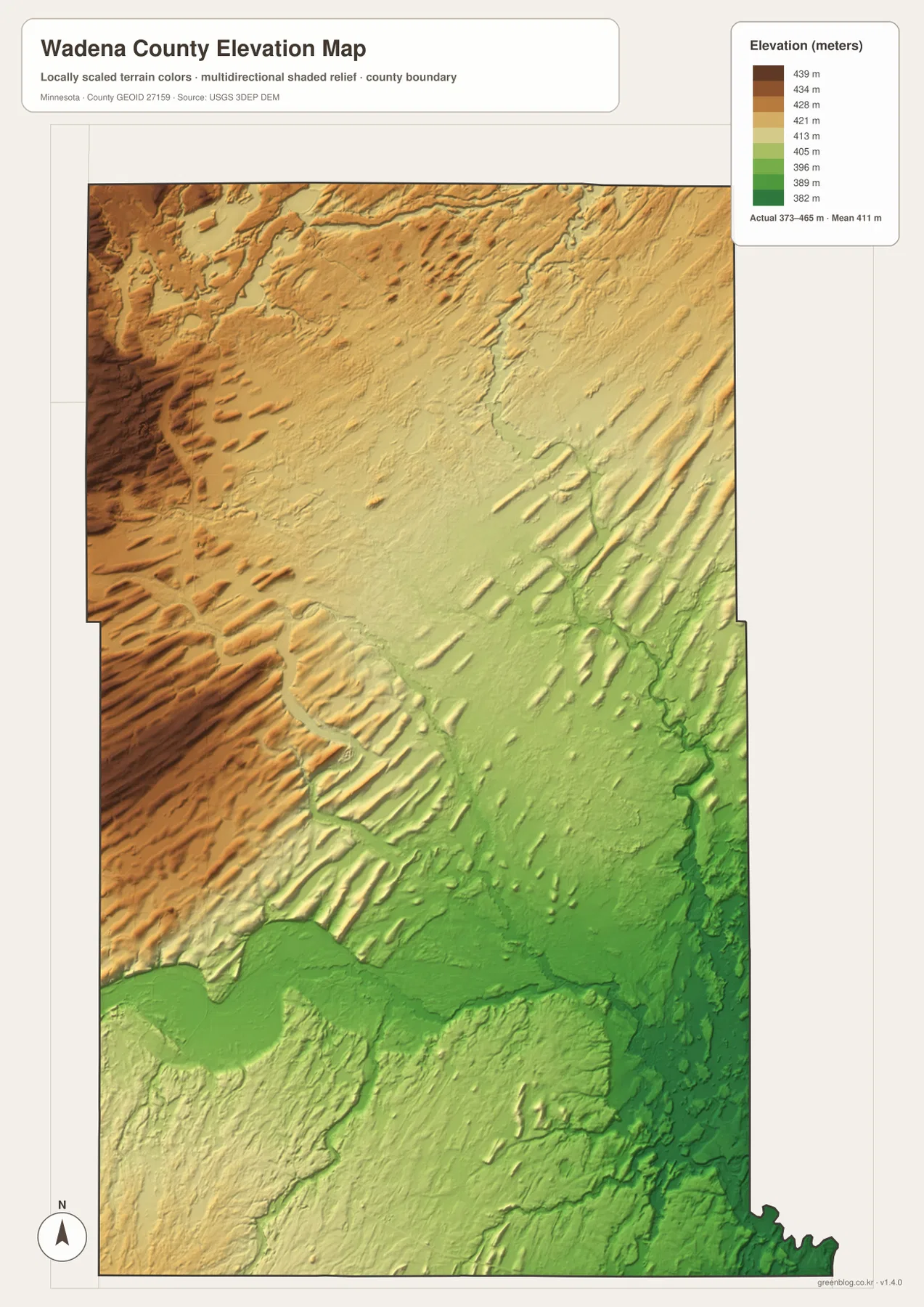
The elevation surface is generalized for county-scale comparison. It should not be used to determine the precise height of a building site, road grade, drainage structure, or property. Surveying, engineering, and detailed site work require higher-resolution source data and field verification. Here the image is most useful as a visual companion to the river map, showing the broad high-to-low change and the valleys cut through it.
Putting the Wadena–Menahga route beside the Leaf River country
A simple way to orient yourself is to begin at Wadena and follow U.S. 71 north. Sebeka provides a middle landmark before Menahga, and Minnesota 227 near the Sebeka area leads the eye east toward Nimrod. Returning to Wadena and following U.S. 10 produces a completely different county cross-section through Verndale and Aldrich toward Staples. Those two routes create a useful framework for nearly every other feature on the maps.
Next, locate Redeye River and Leaf River. Their central and southern courses explain much of the lower terrain seen on the elevation map and help separate the U.S. 10 side of the county from the northern lake-and-river country. In the north, Blueberry River and Crow Wing River are better reference points, and the named lakes make that part of the map feel more broken into smaller water features. The contrast is more informative than simply counting rivers because it shows how the character of the county changes from one corridor to another.
For a printed reference, the general map is best when road labels and county context matter most, while the city map makes the six highlighted communities easier to compare. The water map is the strongest choice for Leaf, Redeye, Cat, Blueberry, Shell, and Crow Wing river relationships. The elevation image adds the 373–465 meter relief and the western-to-southeastern terrain change. Choosing the map that matches the question keeps the distinctive features of Wadena County visible instead of crowding everything into one view.
Frequently Asked Questions
Which roads connect Wadena with Menahga and Staples?
U.S. 71 is the main map reference from Wadena north through Sebeka to Menahga. U.S. 10 heads southeast from the Wadena area through Verndale and Aldrich toward Staples. Actual driving conditions and construction can change, so current MnDOT information should be checked when planning a trip.
Which rivers stand out most on the Wadena County water map?
Redeye River and Leaf River are the clearest central and southern features, with Cat River crossing the middle. The north includes Blueberry River, Shell River, and Crow Wing River, while Wing River and Partridge River appear farther south. Several small lakes, including Blueberry, Lower Twin, Stocking, Finn, and Rice, add useful landmarks in the northern half.
What is the main elevation pattern across Wadena County?
The legend shows an actual range of about 373 to 465 meters and a mean near 411 meters. Higher terrain is concentrated in the west and northwest, while the east and especially the southeast contain more low green areas and river valleys. The map is intended for regional comparison and should not be used as a survey-grade elevation source.
Map File Information
The ZIP contains high-resolution JPG originals of the Wadena County general map, city map, water map, and elevation map shown on this page.
- Included Files: 4 high-resolution JPG maps
Related Maps
Sources and references
- Wadena County official website — county government and local information
- Minnesota Department of Transportation Wadena County Maps — county and road mapping references
- USGS National Hydrography — rivers, streams, and water features
- USGS 3D Elevation Program — elevation and terrain reference data
- Wadena County Historical Society — local history and community resources
Green Map creates custom-edited map images using open geographic data sources such as geoBoundaries, Natural Earth, OpenStreetMap, and government open data. These maps are edited visual materials, not raw data files, and are provided for education, documents, presentations, and graphic reference.