Pine County stretches north–south through east-central Minnesota, with a clear settlement corridor along Interstate 35 and a much more river-dominated landscape to the east. Pine City anchors the south, while Hinckley, Sandstone, Willow River, and Sturgeon Lake form a sequence of communities farther north. Beyond that road corridor, the Kettle, Snake, and St. Croix river systems create a very different geographic pattern of valleys, forests, and wetlands. This guide explains the county, city, water, and elevation maps together, and the four matching high-resolution JPG originals can be downloaded in one ZIP. High-resolution map files are available for download in the section below.
The simplest way to orient the county is to follow I-35 from Pine City northward. Hinckley comes next, followed by Sandstone, Willow River, and Sturgeon Lake. Minnesota 48 runs east from the Hinckley area toward the St. Croix side, while Minnesota 23, 61, and 123 help organize the Sandstone corridor. Once that western north–south axis is clear, the broad eastern half makes more sense as a landscape shaped less by cities and more by rivers and rolling terrain.
Table of Contents
The I-35 Settlement Corridor from Pine City to Sturgeon Lake
The county overview makes the I-35 corridor the strongest transportation feature. Pine City, Hinckley, Sandstone, Willow River, and Sturgeon Lake appear in a long sequence instead of one compact urban cluster. Around Pine City, Minnesota 35, 70, and 107 provide local references, while Hinckley is connected to Minnesota 48 and 23. Sandstone has additional links through Minnesota 61 and 123, which makes it an important midpoint between the southern communities and the northern end of the county.
East of I-35, towns become much more widely separated. Bruno and Kerrick sit on northeastern road connections, while large areas farther east contain few labeled settlements. On the northwest side, Denham, Rutledge, and Finlayson occupy smaller local road networks closer to the main corridor. This pattern makes Pine County feel like a set of linear settlement nodes on the west beside a much broader natural landscape on the east.
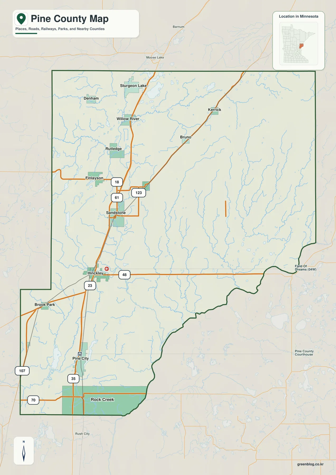
The southern part adds Rock Creek and Pine City as separate settlement areas, with Brook Park near the western edge. The southeastern boundary bends with the St. Croix River valley rather than following a long straight survey line. The overview is useful for understanding roads, towns, and county-scale boundaries, but parcel ownership, zoning, and legal survey questions should be checked with official Pine County land records and mapping resources.
Six Major Communities Stretched along a Long North–South Axis
The ranked city distribution map highlights six communities. Its index lists Pine City at 3,468, Sandstone at 2,482, Rock Creek at 1,748, Hinckley at 1,596, Sturgeon Lake at 568, and Willow River at 342. Pine City is the largest entry, but the map’s more important visual story is the spacing: most of the highlighted communities are stretched along a long north–south corridor rather than packed into one metropolitan area.
Sturgeon Lake and Willow River are the northern pair, Sandstone occupies the north-central section, Hinckley is farther south, and Pine City plus Rock Creek define the southern end. Those steps create a strong sense of distance across the county. The simplified city map is especially useful here because it removes much of the road and water detail, making the relative north–south positions immediately clear.
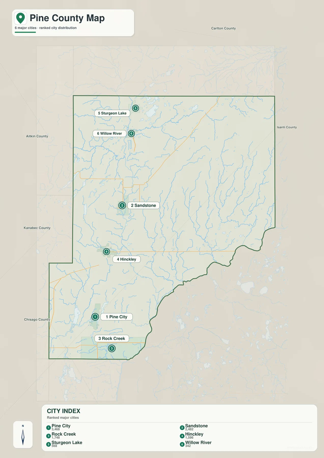
The surrounding labels place Carlton County to the north, Aitkin County to the northwest, Kanabec and Chisago counties to the west and southwest, and Isanti County near the southern side. The eastern boundary connects toward Wisconsin across the St. Croix River corridor. Smaller places such as Bruno, Kerrick, Finlayson, and Rutledge are better seen on the full county overview, since the ranked city map intentionally focuses on only six major communities.
Kettle, Snake, and St. Croix River Systems across a Lake-Rich County
The northern water map is organized around the Kettle River and Willow River systems. Kettle River winds through the upper part of the county near the Sturgeon Lake and Willow River area, while Willow River approaches from the northeast. Island Lake and Sturgeon Lake provide additional northern landmarks. This creates a very different picture from the road map: communities that look connected by I-35 are also separated and linked by a dense network of water and valley terrain.
Across the central and eastern county, Sand Creek, Bear Creek, Lower Tamarack River, and Hay Creek create long narrow drainage lines. Lower Tamarack River and Hay Creek are especially visible in the eastern half, where there are relatively few cities. These streams help explain why the east side is better read as a landscape of watersheds and forested corridors rather than as an extension of the I-35 settlement strip.
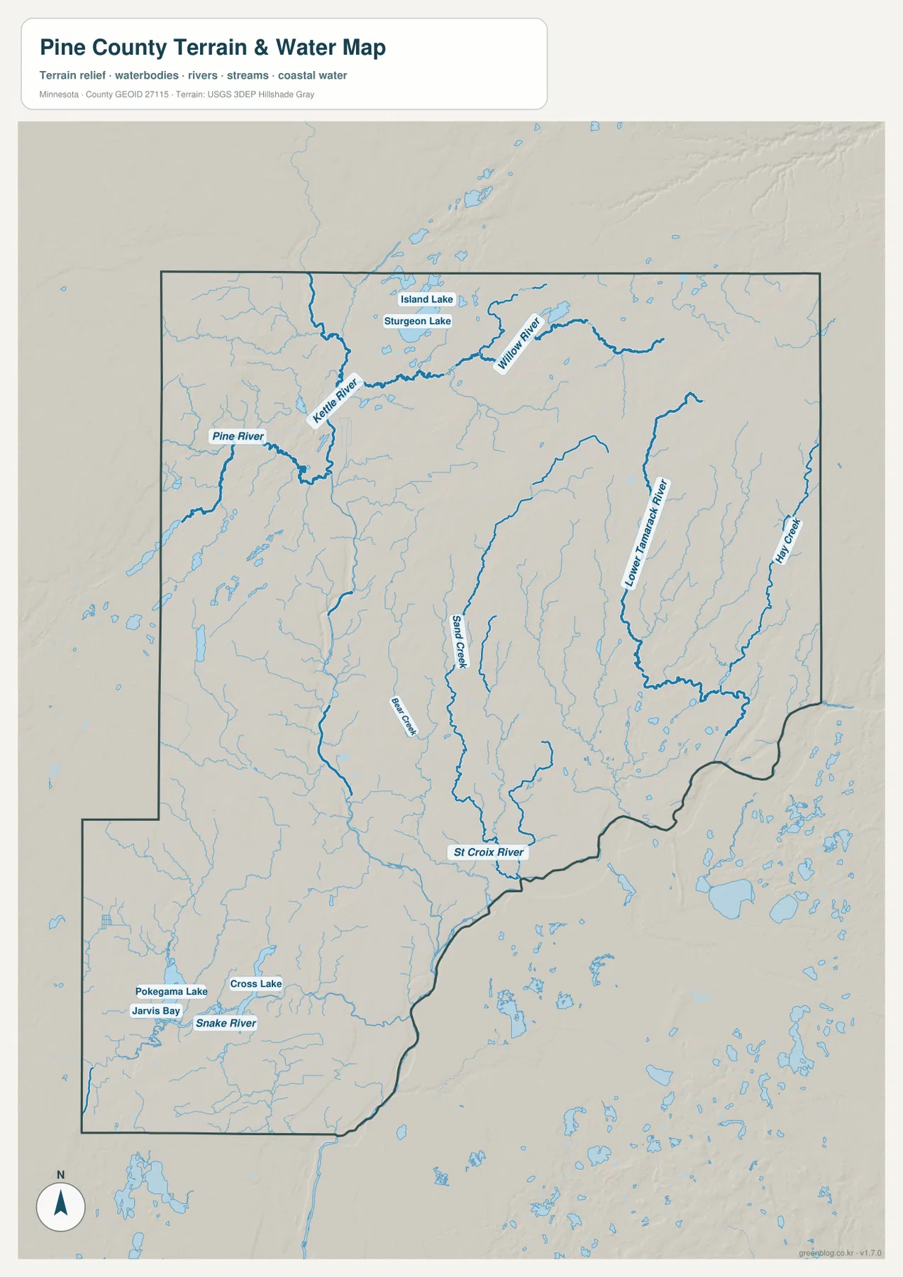
The southern map has another distinct group of waters. Snake River crosses the southwest and south, while Pokegama Lake, Cross Lake, and Jarvis Bay cluster around the Pine City side. Farther southeast, the St. Croix River forms a major boundary feature. Pine County therefore contains several separate water settings: the Kettle system in the north, the Snake River and lake group in the south, and the St. Croix corridor along the southeast.
Minnesota DNR describes the St. Croix River as a long state water trail and notes the Kettle River confluence and nearby rapids as major features of the upper river corridor. That helps place Pine County’s eastern drainage in a broader river system. The supplied water map, however, is for geographic reference only; it should not be used as a floodplain, depth, navigation, shoreline-ownership, or legal-access map.
Northern Uplands Falling toward the St. Croix and Southern Valleys
The elevation map shows a substantial contrast between Pine County’s northern uplands and its lower southern and southeastern valleys. The legend gives an actual range of about 240 to 411 meters and a mean near 327 meters. Brown and orange terrain is widespread across the north and northeast, while greens become increasingly common toward the south and along the St. Croix River side. The county therefore has a clear regional relief pattern even though it does not contain mountainous terrain.
A lower north–south corridor is visible through the north-central part of the county, cutting between higher uplands on both sides. That depression corresponds broadly with major stream valleys in the Kettle River region. Around Sturgeon Lake and Willow River, higher ground and lower water-filled depressions alternate over short distances, creating a more complex surface than a simple high plateau.
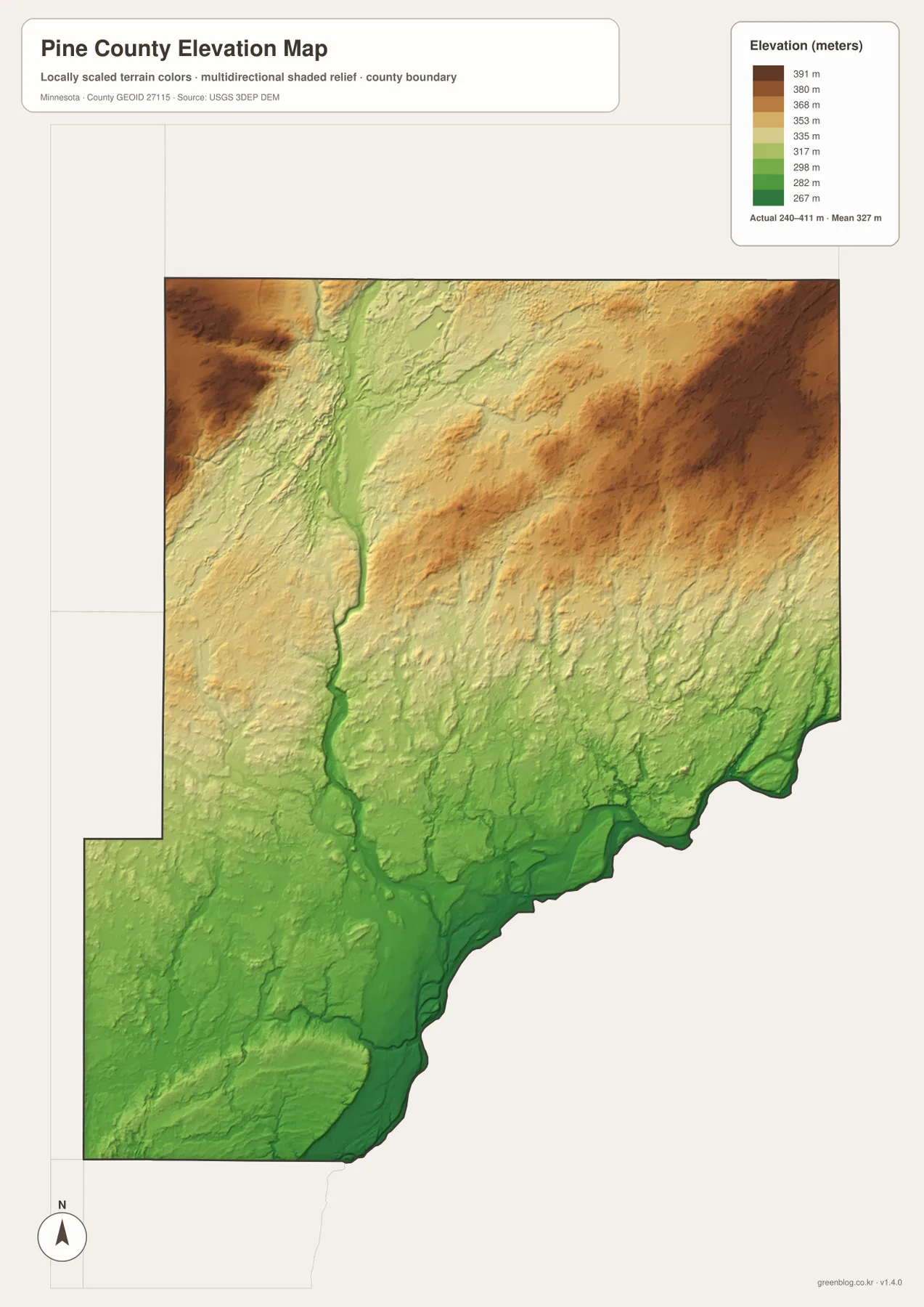
The eastern and northeastern ridges are substantially higher than the St. Croix valley. In the southeast, the boundary river occupies a deep green lowland, and southern stream corridors around the Snake River and Pine City lake area are also lower than the surrounding uplands. Comparing the water and elevation maps makes the drainage pattern easy to understand: streams follow lower corridors between hills before reaching the larger rivers.
The colors are locally scaled to show variation inside Pine County, so the same green or brown shade on another county map may represent a different absolute elevation. The shaded surface is designed for broad geographic interpretation rather than survey-grade measurement. Engineering, drainage design, construction, and legal elevation work require more precise source data or field measurements.
Choosing the Best View for Roads, Rivers, Lakes, and Relief
For roads and settlement orientation, start with the county overview. Follow I-35 from Pine City through Hinckley and Sandstone to Willow River and Sturgeon Lake, then use Minnesota 48, 23, 61, and 123 to understand the main east–west branches. The ranked city map is better when the goal is simply to compare the six highlighted communities and their long north–south spacing.
For natural geography, begin with the Kettle and Willow rivers in the north, then move east to Lower Tamarack River and Hay Creek before finishing with Snake River, Pokegama Lake, Cross Lake, and the St. Croix River in the south. The elevation map adds the broader setting by showing high northern and northeastern ground above lower stream valleys and the southeastern river corridor.
The WebP previews on the page are optimized for quick viewing. The downloadable ZIP contains the corresponding high-resolution JPG originals for the county overview, city distribution, water, and elevation maps. Each file is 2572 by 3638 pixels, making the originals more useful for vertical printing or for zooming into small road, river, and place labels than a browser screenshot.
A practical way to read Pine County is to begin in Pine City, travel north conceptually along I-35 through Hinckley and Sandstone to Sturgeon Lake, and then shift east to the river-dominated half of the county. Finish by comparing the Kettle, Snake, and St. Croix systems with the elevation view. That sequence connects the county’s strongest geographic contrast: a linear western settlement corridor beside a broader landscape of high ground, stream valleys, and major rivers.
Frequently Asked Questions
Which map is best for locating Pine City, Hinckley, and Sandstone?
Start with the county overview. Pine City, Hinckley, and Sandstone lie along the I-35 corridor, with Willow River and Sturgeon Lake continuing farther north. The ranked city map is useful as a second view when you want to compare the six highlighted communities without the extra road and river detail.
Where are the Kettle River and St. Croix River in Pine County?
The water map shows Kettle River in the northern part of the county and the St. Croix River along the southeastern boundary. Lower Tamarack River and Hay Creek occupy the eastern side and drain toward the larger river corridor. Current Minnesota DNR information should be checked separately for paddling conditions, access, or safety.
How does elevation change across Pine County?
The map legend shows an actual range of about 240–411 meters with a mean near 327 meters. Northern and northeastern uplands are generally higher, while the St. Croix River valley and many southern stream corridors are lower. A lower north-central corridor also cuts through the higher northern terrain.
Map File Information
The ZIP contains the original high-resolution JPG versions of the Pine County overview, city distribution, water, and elevation maps.
- File Type: ZIP containing 4 JPG files
Related Maps
Sources and References
- Pine County official website – county government and local information
- Minnesota DNR Banning State Park – Sandstone and Kettle River landscape reference
- Minnesota DNR St. Croix River State Water Trail – St. Croix River and Kettle River confluence context
- U.S. Census Bureau TIGER/Line Shapefiles – county boundary and geographic reference data
- USGS 3D Elevation Program – elevation reference data
Green Map creates custom-edited map images using open geographic data sources such as geoBoundaries, Natural Earth, OpenStreetMap, and government open data. These maps are edited visual materials, not raw data files, and are provided for education, documents, presentations, and graphic reference.