Carlton County lies in northeastern Minnesota, where Cloquet anchors the most developed northeastern cluster and smaller communities such as Carlton, Scanlon, Moose Lake, Barnum, and Cromwell are spread across a much larger interior. The St. Louis River cuts a dramatic low corridor in the east, while the western and northwestern parts of the county rise onto much higher ground. The result is a county where road, water, and elevation maps reveal very different sides of the same landscape. High-resolution map files are available for download in the section below.
This page combines a general county map, a six-city ranking index, a water map, and an elevation map with an actual range of roughly 185 to 440 meters. High-resolution A3 JPG originals for all four maps are available together in one ZIP for printing, classroom use, trip preparation, and side-by-side geographic comparison.
Table of Contents
Cloquet, Moose Lake, and the I-35–MN-210 road framework
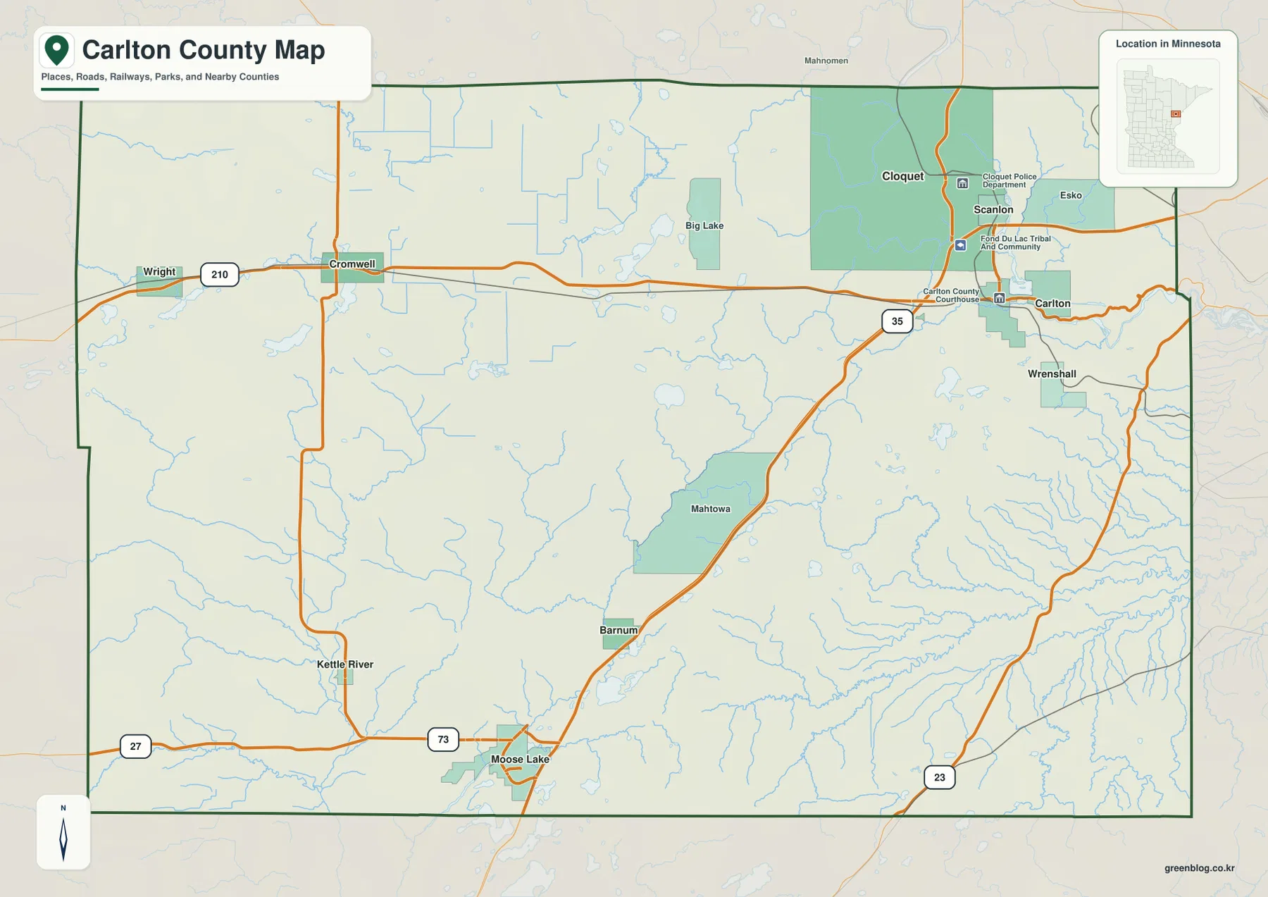
Cloquet is the strongest urban reference on the general county map. I-35 approaches from Moose Lake, Barnum, and Mahtowa before reaching the Carlton–Cloquet area and continuing toward Duluth. Cloquet, Scanlon, Carlton, and Esko form the county’s tightest cluster of developed places, making the northeast look much denser than the broad western interior.
MN-210 provides the main east–west connection. It crosses the county from Wright and Cromwell toward Cloquet and Carlton, linking small western communities with the larger northeastern population center. Near Cromwell, MN-73 runs south toward Moose Lake, while MN-27 provides another east–west reference through the southern side.
Moose Lake is a major southern road junction where I-35, MN-27, and MN-73 come close together. Barnum lies farther north along I-35, and Kettle River is west of the freeway. MN-23 appears in the southeast near the Wrenshall side, creating a separate route toward neighboring counties.
Selected facilities, including Fond du Lac Tribal and Community College and county government sites, are shown around the Cloquet–Carlton area. The map is intended for county-scale orientation rather than live traffic or detailed street navigation. Using I-35 and MN-210 first makes it easy to place the northeast city cluster, the southern Moose Lake corridor, and the high western interior.
Six ranked communities led by Cloquet
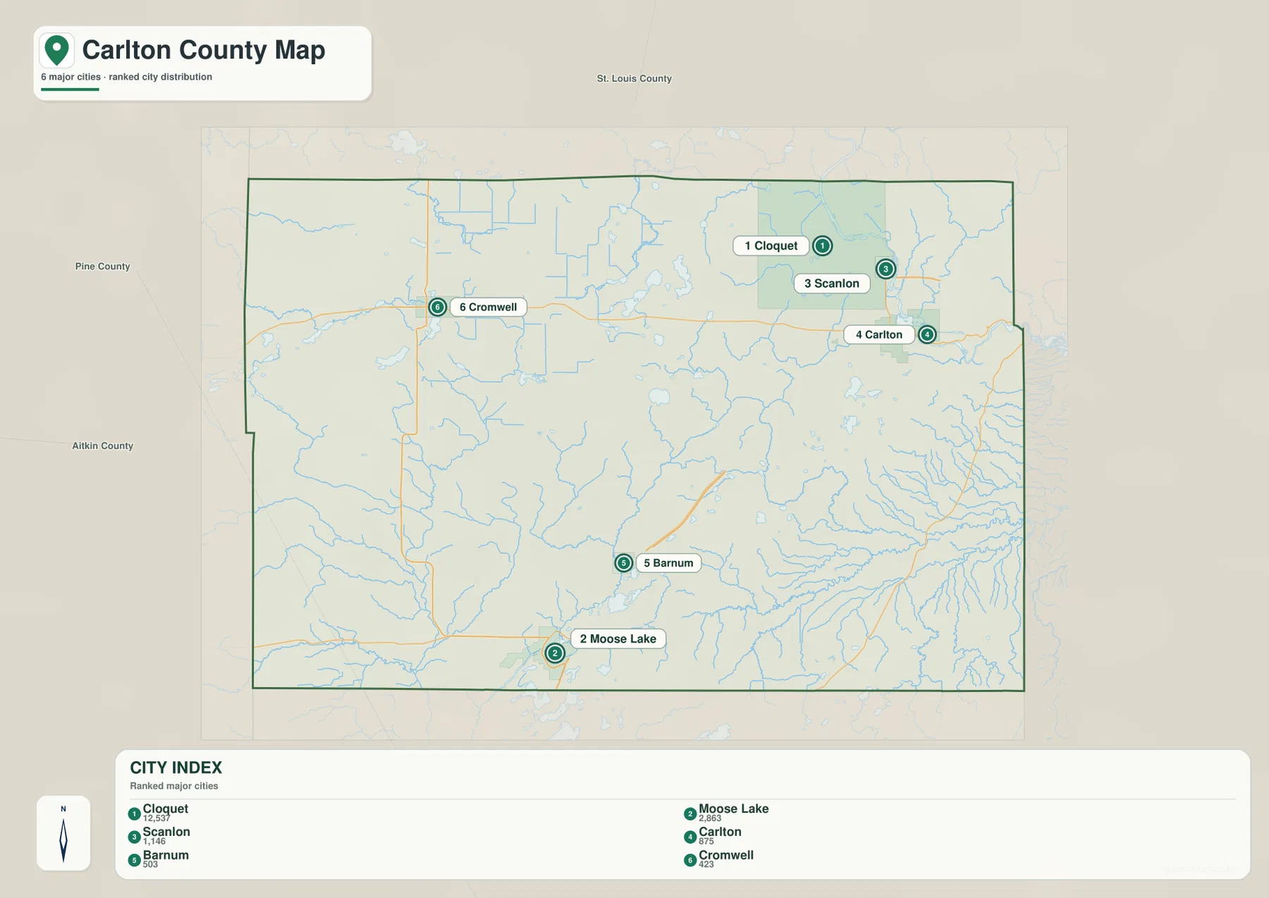
The city index ranks six selected communities. Cloquet is number 1 with a printed value of 12,537, followed by Moose Lake at 2,863, Scanlon at 1,146, Carlton at 875, Barnum at 503, and Cromwell at 423. These figures are reproduced from the supplied city-index graphic and are not presented here as newly calculated population estimates.
The distribution emphasizes the northeastern concentration. Cloquet, Scanlon, and Carlton are close together, while Moose Lake is near the southern edge, Barnum lies between Moose Lake and the northeast, and Cromwell sits much farther west. Half of the ranked places are clustered around Cloquet, but the county itself extends far beyond that city area.
There are no connector lines or mileage labels on this city map. It is a ranking and location graphic rather than a distance chart. Use it to compare where the six selected communities sit within the county, then refer to the general road map or a current routing service when actual driving mileage or travel time is needed.
St. Louis River, Thomson Reservoir, and the inland river network
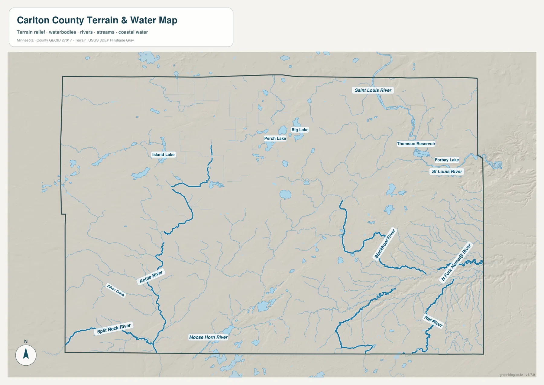
The St. Louis River is the defining water feature in the northeast. It bends through the Cloquet–Carlton side of the county and passes the Thomson Reservoir area, creating a broad river corridor that is also one of the lowest parts of the elevation map. The river gives the developed northeastern corner a much more rugged physical setting than the road map alone suggests.
Thomson Reservoir and Forbay Lake are labeled near the St. Louis River, with numerous small tributaries entering the main channel. Minnesota DNR’s Jay Cooke State Park information describes the St. Louis River gorge as a landscape of exposed rock, steep valleys, rapids, and river overlooks. That official description closely matches the sharp relief visible in the county’s northeastern river corridor.
The Kettle River is the strongest named river in the western and southwestern interior. It receives smaller tributaries as it runs southward, while Silver Creek and Split Rock River appear farther west and southwest. Moose Horn River crosses the southern interior and provides another important local water reference near the Moose Lake side.
The southeast contains a separate set of deeply cut waterways. Blackhoof River, North Fork Nemadji River, and Net River are all labeled, and their valleys stand out strongly on the elevation map. These streams show that the eastern lowlands are not controlled by the St. Louis River alone; several river systems descend across the steep eastern side of the county.
Named lakes are scattered through the interior. Island Lake lies in the west-central area, while Perch Lake and Big Lake are closer to the north-central part. Thomson Reservoir dominates the northeast. Together with many smaller unnamed lakes and tributaries, they make Carlton County a water-rich landscape well beyond its two largest river systems.
Use the water map for names, relative positions, and broad drainage relationships. It does not show flood probability, legal shoreline limits, navigation depth, parcel ownership, or current water conditions. Those questions require current products from the responsible public agency.
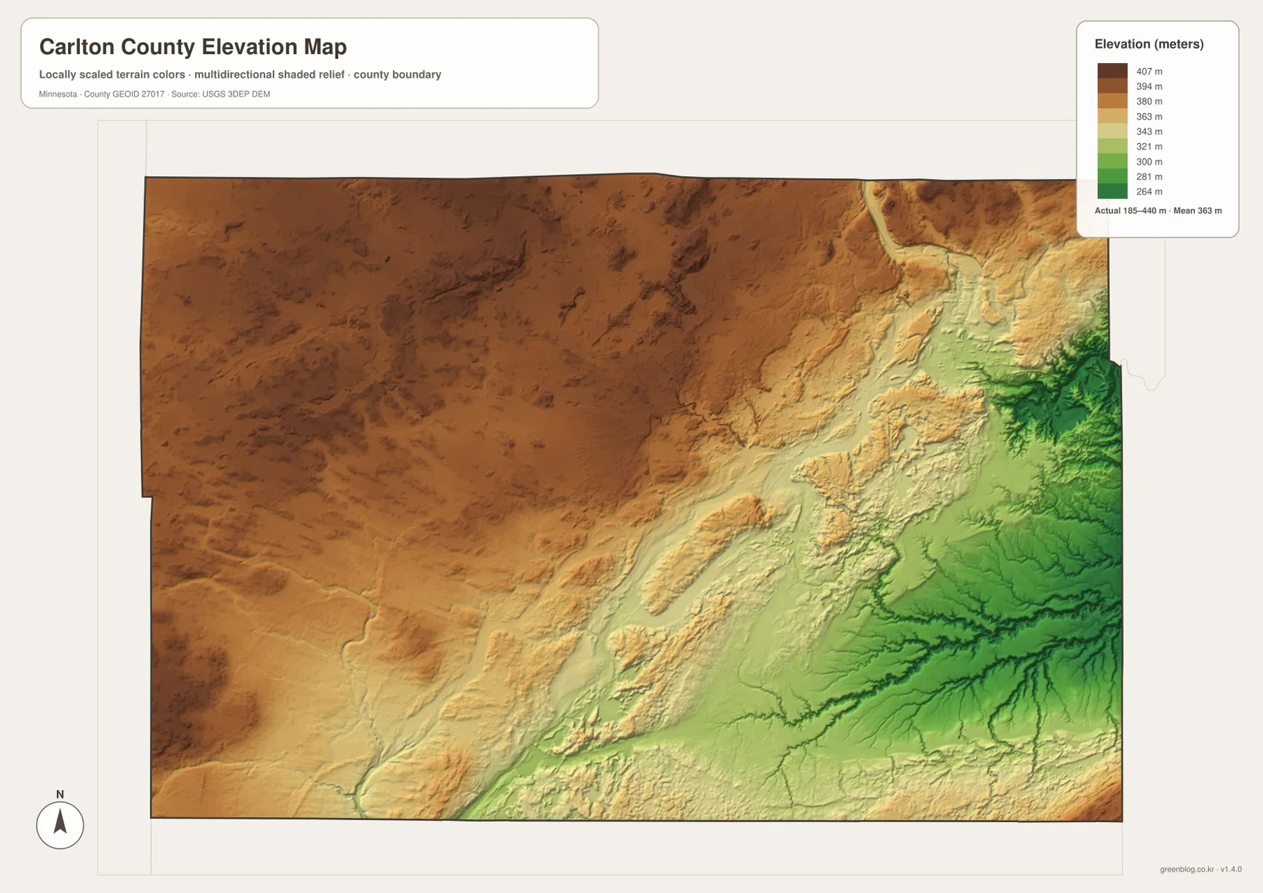
Elevation from 185 to 440 meters
The elevation map reports an actual range of about 185 to 440 meters and a mean near 363 meters. Greens represent lower terrain, while tan and brown colors mark higher ground. Most of the western and northwestern county is high, broad upland terrain, while the eastern side drops sharply toward deep river valleys.
The strongest transition runs diagonally across the county. High western surfaces give way to long ridges, steep slopes, and narrow valleys as the land descends eastward. Around the St. Louis River and the Blackhoof–Nemadji drainage systems, deep green corridors mark some of the lowest terrain in the county.
Cloquet and Carlton occupy the transition between the high interior and the St. Louis River gorge. Farther southeast, relief drops even more sharply into branching river valleys. By contrast, Cromwell and Wright sit on substantially higher western ground where the surface is broad and elevated even though local lakes and small streams remain present.
With roughly 255 meters between the mapped minimum and maximum, Carlton County has a large internal relief range for Minnesota. This surface is intended for broad terrain comparison rather than survey-grade measurement. Precise construction, drainage, engineering, or site work requires more detailed official elevation data and field verification.
Why Cloquet, Cromwell, and Moose Lake occupy different landscapes
Cloquet brings roads, water, and relief together in the northeast. I-35 and MN-210 provide the main transport references, Scanlon and Carlton are nearby, and the St. Louis River and Thomson Reservoir lie just to the east. The elevation layer places the city near a major drop from the high interior into the river gorge.
Cromwell and Wright represent the western uplands. MN-210 is the clearest road reference, communities are much smaller, and the terrain is substantially higher than the eastern river valleys. Island Lake and smaller waterways remain important, but the defining feature is the broad elevated interior rather than a deep gorge.
Moose Lake and Barnum form a third setting in the south. I-35 dominates the road pattern, while Kettle River and Moose Horn River are nearby. Moving southeast from this corridor, the land descends quickly into the Blackhoof and Nemadji drainage valleys. Comparing all four maps makes the west-to-east topographic shift much easier to understand.
The map set works well for general county orientation, school assignments, local-history presentations, and trip preparation. It does not replace parcel records, zoning documents, flood-regulation products, legal surveys, or real-time transportation information, so specialized decisions should rely on current county, state, or federal sources.
Frequently Asked Questions
Which maps best show the terrain difference between Cloquet and Cromwell?
Start with the general county map to compare their locations along MN-210, then use the elevation map. Cromwell lies on the high western interior, while Cloquet is near the steep descent into the St. Louis River valley.
Are the city-index values current population estimates?
The values described here are the numbers printed in the supplied city-index graphic. For the latest population figures, use current U.S. Census Bureau or Carlton County statistics rather than treating the map values as a new estimate.
Can the 185–440 meter elevation range be used for engineering or surveying?
No. The elevation layer is suitable for broad comparison of higher and lower terrain, but precise construction, drainage, engineering, or survey work requires more detailed official elevation data and field verification.
Map File Information
A ZIP containing the high-resolution A3 JPG originals for the Carlton County map, city index, water map, and elevation map.
- Included Files: county map, city index map, water map, elevation map
- File Type: JPG
Related Maps
Sources and references
- U.S. Census Bureau TIGER/Line Shapefiles – official geographic files for county boundaries, roads, and place references.
- USGS National Hydrography – federal source for rivers, streams, lakes, and other hydrographic features.
- USGS 3D Elevation Program – official U.S. elevation and terrain data resources.
- Carlton County official website – official county government, resident services, and local information.
- Minnesota DNR – Jay Cooke State Park – official information about the St. Louis River gorge, trails, rock formations, and river landscape.
Green Map creates custom-edited map images using open geographic data sources such as geoBoundaries, Natural Earth, OpenStreetMap, and government open data. These maps are edited visual materials, not raw data files, and are provided for education, documents, presentations, and graphic reference.