Cheboygan County occupies the northern end of Michigan’s Lower Peninsula, stretching from the Straits of Mackinac and Lake Huron shoreline into a broad inland lake and river country. The city of Cheboygan sits near the northern shore, Indian River is in the west-central county, Wolverine lies to the southwest, and Tower provides an eastern reference. Mackinaw City marks the northwestern edge, while Burt Lake, Mullett Lake, and Black Lake dominate the interior water landscape.
This page separates the county into a road-and-place map, a two-city distribution map, a terrain-and-water map, and an elevation map. High-resolution JPG originals of the supplied maps are available together in a ZIP download for printing, classroom materials, presentations, and detailed local reference. Comparing roads, water, and relief makes the contrast between the northern lowlands and the higher southern interior much easier to understand.
US-23 follows the northern shoreline through Cheboygan, US-31 provides a reference near Mackinaw City, and I-75 runs through the western side near Indian River and Wolverine. M-27 helps organize the west-central interior, while M-33 and M-68 cross the eastern side near Tower. M-212 reaches south from the Cheboygan area, giving the county several distinct north-south and east-west travel patterns.
Table of Contents
Northern shoreline roads connect Cheboygan with Mackinaw City and the inland county
Cheboygan is the clearest northern road reference on the general map. US-23 follows the shoreline and links the city with the Mackinaw City side to the west and Lake Huron communities to the east. Roads leaving Cheboygan turn south toward the Mullett Lake and Black Lake region, where numerous rivers and wetlands make the inland pattern more complex.
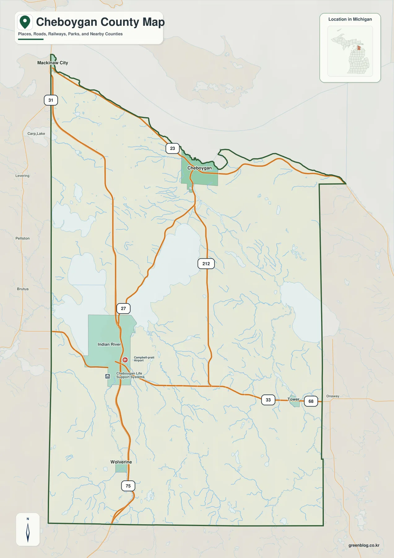
Mackinaw City anchors the northwestern corner, where US-31 and shoreline routes provide the main orientation. The county boundary then follows a long arc toward Cheboygan. This northern strip is closely tied to the Straits and Lake Huron, creating a road environment that differs from the lake-filled interior farther south.
Indian River sits in the west-central county near I-75 and M-27. Cheboygan Life Support Systems and Campbell-Pratt Airport are labeled nearby, providing additional orientation. Burt Lake and Mullett Lake frame the surrounding area, so roads repeatedly adjust to channels, wetlands, and lake margins rather than following a simple grid.
Wolverine lies farther south along the I-75 side and serves as a reference for the county’s higher inland terrain. The road network is more rural and dispersed here than around Cheboygan, and nearby river valleys cut through rolling ground. The elevation map makes the change from northern lowlands to southern uplands especially clear.
Tower lies toward the eastern side near M-33 and M-68. Black Lake, Black River, and the Pigeon River system shape much of the surrounding landscape. This map is intended for regional orientation rather than live navigation, so current traffic, construction, closures, and seasonal road conditions should be checked with up-to-date Michigan transportation services.
Cheboygan and Wolverine highlight the county’s north-south settlement contrast
The city-distribution map removes most road detail and highlights only Cheboygan and Wolverine. Cheboygan appears near the northern shoreline, while Wolverine sits far to the southwest. With only two ranked places, the map gives a simple visual sense of the county’s long north-south extent without suggesting that these are the only communities in the county.
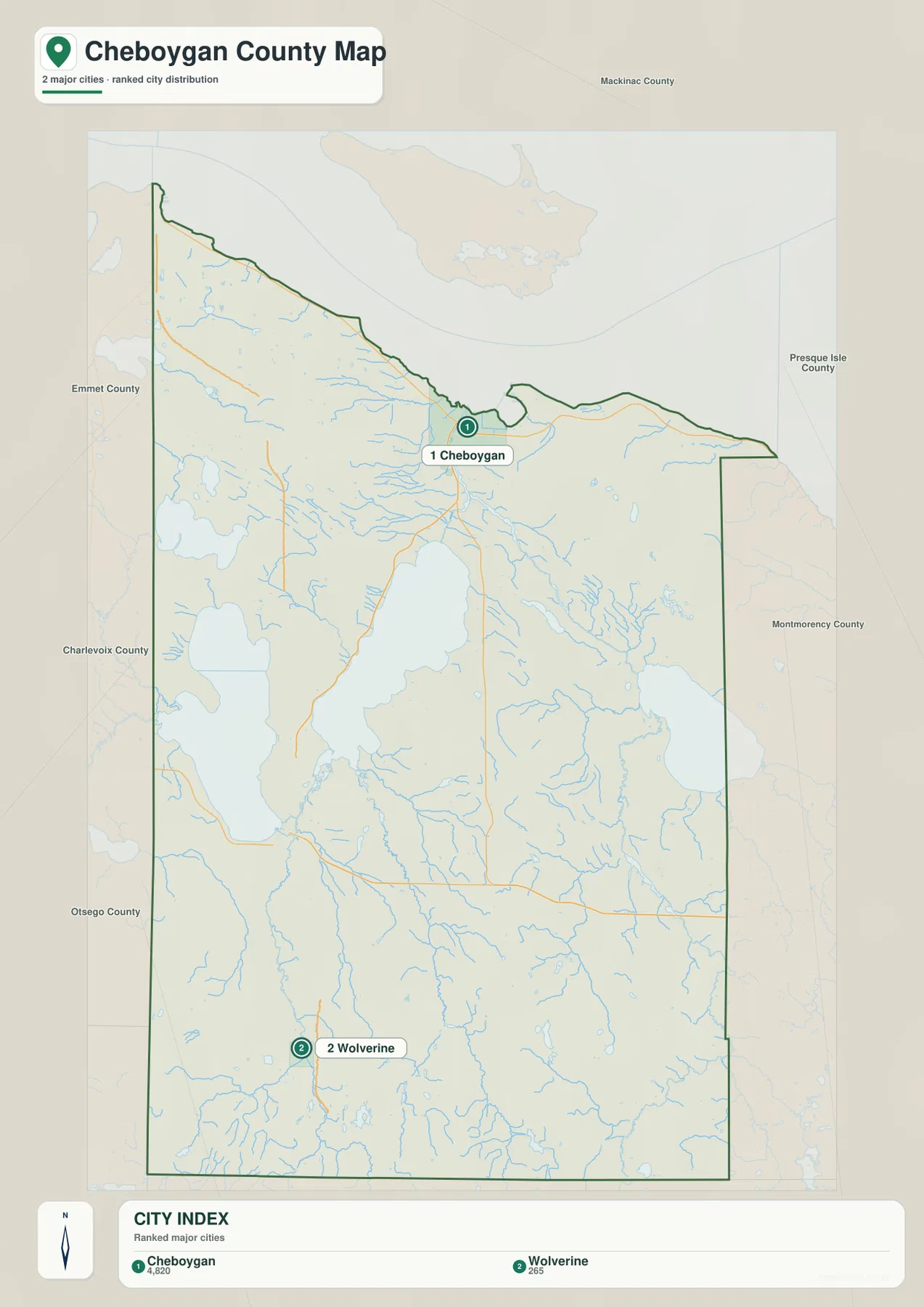
The CITY INDEX lists reference values of 4,820 for Cheboygan and 265 for Wolverine. These figures are best treated as ranking values used for the map rather than as the latest official population counts. Current population estimates should be checked in the relevant U.S. Census Bureau release.
Cheboygan is the dominant northern marker and corresponds with the densest concentration of roads on the general map. The water map adds the Cheboygan River corridor immediately inland, and the elevation map shows that the city lies within low terrain connected to the Lake Huron shoreline.
Wolverine represents a very different setting. It is an inland community near I-75, close to the Sturgeon River system and substantially higher southern terrain. The city-distribution map has no connector line or distance measurement, so it should be used for relative location only rather than for estimating travel distance.
Mackinaw City, Indian River, and Tower appear on the general map but are not included in this two-city ranking. For smaller place names, road routes, or the relationship between towns and lakes, the general map is therefore the more complete reference.
Mullett Lake, Burt Lake, Black Lake, and the Cheboygan River system
The terrain-and-water map is dominated by three large inland lakes: Burt Lake in the west, Mullett Lake in the center, and Black Lake in the east. These lakes are linked to extensive river and stream networks, while Cheboygan River continues north toward the Lake Huron shoreline. Water is therefore a defining feature across much of the county, not just along the coast.
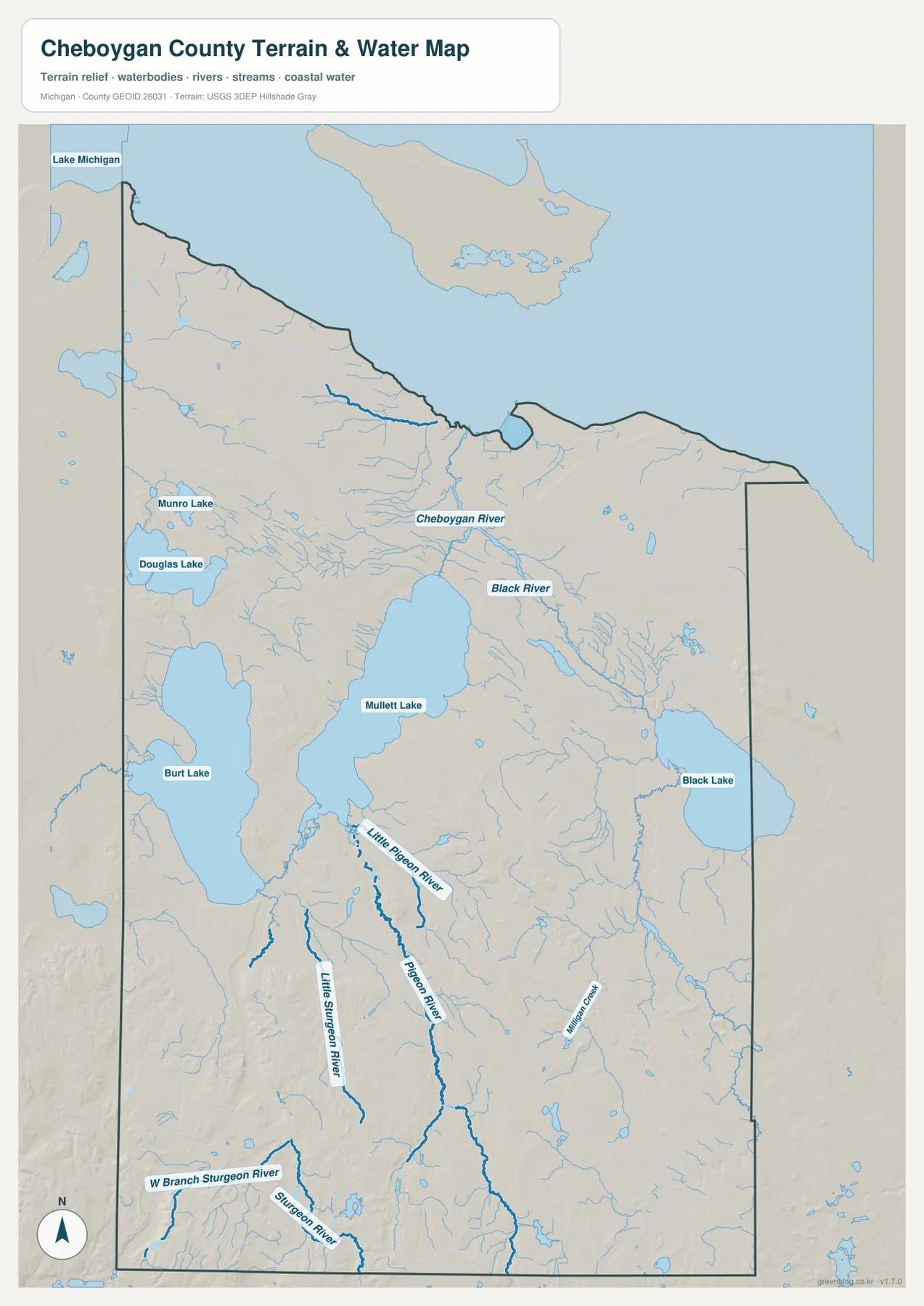
Cheboygan River leaves the Mullett Lake side and flows north toward the city and Lake Huron. Black River approaches from the east, draining the Black Lake region before joining the broader northern system. Both river corridors line up with dark-green lowlands on the elevation map, emphasizing how strongly the county’s northern terrain is shaped by water.
Burt Lake lies west of Mullett Lake, with Douglas Lake and Munro Lake farther north and west. Indian River occupies the narrow water-rich area between the two major lakes. Numerous smaller tributaries, channels, and wetlands fill the surrounding lowlands, making this one of the county’s most intricate water landscapes.
The southern interior contains Pigeon River and Little Pigeon River, while Sturgeon River, West Branch Sturgeon River, and Little Sturgeon River are prominent farther southwest. Milligan Creek appears in the southeast. These waterways cut through higher rolling terrain and create lower valleys that are easy to recognize on the elevation surface.
This water map is a geographic reference, not a flood or navigation chart. It does not provide depth, current speed, water quality, legal access, flood zones, or boating restrictions. Fishing, paddling, shoreline activities, and flood planning should use current Michigan and federal information in addition to this county-scale view.
Northern lake lowlands rise into higher southern and southwestern terrain
The elevation map removes most roads and labels and uses locally scaled colors with shaded relief. Its legend reports an actual elevation range of about 156 to 394 meters and a mean of 229 meters. Dark green represents the lower parts of Cheboygan County, lighter green and yellow mark intermediate terrain, and brown identifies the highest ground. Because the scale is local, identical colors on another county map should not be assumed to represent the same elevation.
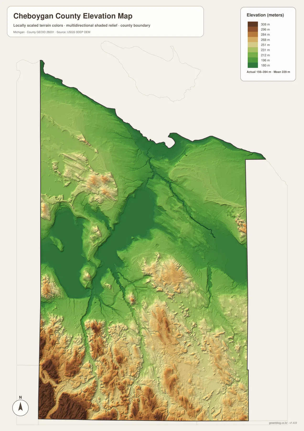
The darkest greens follow the northern shoreline, Cheboygan River corridor, and the broad basins around Mullett Lake, Burt Lake, and Black Lake. Cheboygan itself lies within this lower northern setting. The water and elevation maps align closely, showing how major lakes and rivers occupy the broadest low areas.
Around the west-central lakes, relief begins to increase away from the water. Douglas Lake and the Burt Lake side are surrounded by lighter greens and localized yellow ridges, while stream valleys cut lower paths through them. The result is a rolling margin around the lake basins rather than one completely flat plain.
Higher yellow, orange, and brown terrain becomes much more common toward the south and southwest. The strongest relief appears close to the Otsego County side, where high ridges and deep valleys create a rugged surface compared with the broad northern lowlands. The map’s reported maximum near 394 meters highlights how large that elevation change can be within one county.
Black Lake creates another broad low basin in the east, but higher ground returns along its eastern and southern margins. Black River and Pigeon River carve green corridors through those uplands. The overall pattern is lower in the north and around the large lakes, higher toward the south, with river valleys interrupting that general rise.
This elevation surface is a generalized county-scale reference and should not be treated as survey-grade measurement. Exact parcel elevations, engineering slopes, drainage design, construction planning, and other precision work require authoritative detailed sources such as the USGS 3D Elevation Program rather than estimates from the map colors.
Comparing Cheboygan, Indian River, Wolverine, and the Black Lake side
Cheboygan is the most useful northern comparison point. The general map shows US-23 and the shoreline road network, the city map makes it the primary ranked settlement, the water map places Cheboygan River immediately inland, and the elevation view shows a broad low corridor connected to Lake Huron.
Indian River explains the west-central lake country. I-75 and M-27 provide road orientation, while Burt Lake and Mullett Lake dominate the water map. The elevation surface remains low near the lake basins but rises into short ridges and hills nearby, producing a varied landscape over relatively small distances.
Wolverine represents the southern interior. I-75 provides the main transportation reference, the Sturgeon River system occupies nearby valleys, and the elevation map shows much more yellow and brown terrain than around Cheboygan. This contrast makes the north-south change in the county especially easy to understand.
Tower and the Black Lake side provide an eastern comparison. M-33 and M-68 cross the area, while Black Lake and Black River dominate the water setting. Elevation is low around the lake itself but rises along the surrounding uplands, showing the same water-and-relief relationship found around the other major basins.
For practical use, the general map is best for named roads and places, the city map for the relative location of Cheboygan and Wolverine, the water map for major lakes and river networks, and the elevation map for the contrast between northern lowlands and southern hills. Used together, the maps provide a fuller picture without forcing every detail into one image.
Choosing a Cheboygan County map and using the downloadable files
Use the general county map when you need Cheboygan, Mackinaw City, Indian River, Wolverine, Tower, US-23, US-31, I-75, M-27, M-33, and M-68 in one view. The city-distribution map is cleaner when the main question is where Cheboygan and Wolverine sit within the county. Choose the terrain-and-water map for the large lakes and river systems, and the elevation map for the transition from northern lowlands to the higher southern interior.
The WebP images on this page are optimized for browser viewing. The ZIP below contains the original high-resolution JPG versions of the general county map, city-distribution map, terrain-and-water map, and elevation map. Those originals are better suited to printing, classroom handouts, presentations, and large displays where additional image detail is useful.
Frequently Asked Questions
Which map is best for finding Cheboygan, Indian River, and Wolverine together?
Use the general county map. It shows US-23, I-75, M-27, and the major place labels in one view, making it easier to compare the northern shoreline with the inland county. The city-distribution map is also useful when you only need the relative positions of Cheboygan and Wolverine.
Which map shows Mullett Lake, Burt Lake, and Cheboygan River?
Use the terrain-and-water map. It shows Mullett Lake, Burt Lake, Black Lake, Cheboygan River, Black River, Pigeon River, Sturgeon River, and numerous smaller waters. It is a location reference and does not provide flood, depth, navigation, water-quality, or access information.
Where does Cheboygan County appear highest on the elevation map?
The northern shoreline and major lake basins are generally lower, while yellow and brown hills become much more widespread toward the south and especially the southwest. The legend reports an actual range of roughly 156 to 394 meters, but exact site elevations should be checked in authoritative elevation data.
Map File Information
The ZIP contains the high-resolution JPG originals for the Cheboygan County general map, city-distribution map, terrain-and-water map, and elevation map described on this page.
- Included Files: general county map, city-distribution map, terrain-and-water map, elevation map
- File Type: JPG
Related Maps
Sources and reference links
For county government and local information, see the official Cheboygan County website. For the underlying types of boundary, hydrography, and elevation information used in county mapping, consult U.S. Census Bureau TIGER/Line, USGS National Hydrography, and the USGS 3D Elevation Program. These page maps are general reference products and do not replace legal boundaries, survey data, navigation charts, or flood determinations.
Green Map creates custom-edited map images using open geographic data sources such as geoBoundaries, Natural Earth, OpenStreetMap, and government open data. These maps are edited visual materials, not raw data files, and are provided for education, documents, presentations, and graphic reference.