Alpena County sits on the Lake Huron side of Michigan’s Lower Peninsula, with the city of Alpena occupying a prominent position on Thunder Bay. The county extends well inland from that shoreline. US-23 follows the eastern side, M-32 runs west from Alpena across the county, and M-65 provides a north-south reference farther west. Those three roads make it easy to understand how a coastal city connects with a much larger rural interior.
This page brings together a county reference map, a major-city map, a terrain-and-water map, and an elevation map. The maps show the location of Alpena, the Thunder Bay River system, Long Lake, Fletcher Pond, Beaver Lake, the Lake Huron shore, and the higher ground to the west and southwest. The original high-resolution JPG versions of all four maps are available together in one ZIP download for printing, classroom work, presentations, or detailed viewing.
The county changes noticeably from east to west. Around Alpena and Thunder Bay, low ground reaches the Lake Huron shore, while the western and southwestern interior contains more pronounced hills. Rivers and lakes also divide the interior into a series of valleys and low areas, so the landscape is more varied than a simple flat coastal plain.
Table of Contents
Roads from Alpena and Lake Huron into the interior
The county reference map is anchored by Alpena on Thunder Bay. US-23 passes through the eastern part of the county and continues along the Lake Huron side, while M-32 leaves Alpena and heads west across the interior. Near the western side, M-65 runs north and south. Together, these highways give a clear framework for locating smaller roads and understanding the county’s shape.
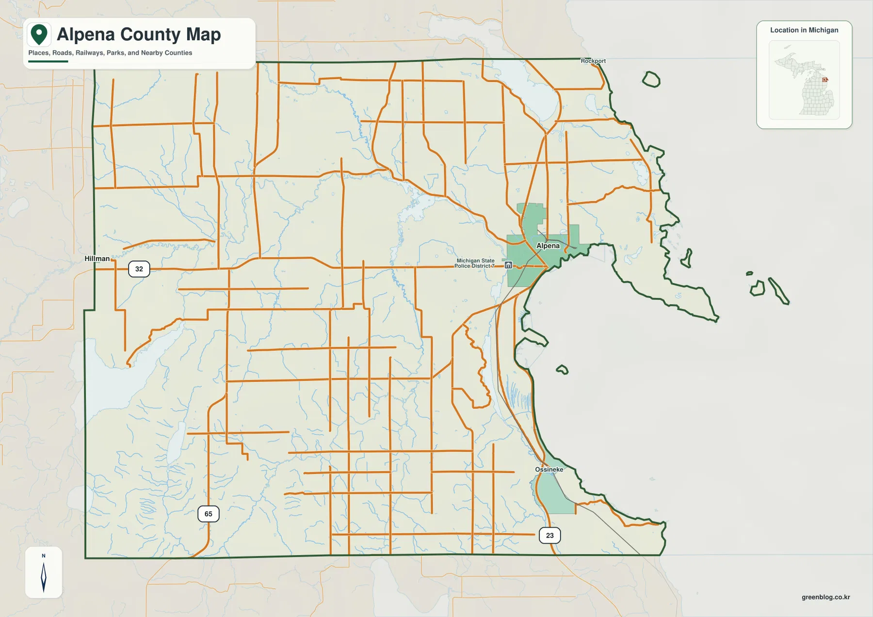
US-23 is especially useful for following the shoreline side of the county. South of Alpena, the map continues toward Ossineke, while the northern coast leads toward Rockport and the Presque Isle County direction. These nearby labels help orient the map, but the dark county outline remains the main boundary for the page.
M-32 is the clearest east-west road on the map. It begins at Alpena and crosses the middle of the county toward the Hillman direction. A number of local roads meet it along the way, making M-32 a practical reference for locating places that are not directly on Lake Huron. The route also makes the county’s inland width much easier to see.
M-65 serves a different part of the county. It runs through the west and is separated from Alpena by a broad stretch of local roads, streams, and low-lying valleys. Looking at M-32 and M-65 together is useful when comparing movement across the county with movement along its western side.
The local road pattern becomes denser around Alpena and more dispersed farther inland. Some western roads follow long straight segments, while others bend around water and uneven ground. The map is best used for regional orientation rather than turn-by-turn navigation, because it does not show live construction, closures, traffic, or seasonal road conditions.
The county border also helps explain the region around Alpena. Presque Isle County lies to the north, Montmorency County is to the west, Alcona County is to the southwest, and the Lake Huron coast forms the broad eastern edge. For legal boundaries, parcel work, or surveying, a current official GIS or Census boundary source should be used instead of a general reference image.
Alpena as the county’s primary urban reference point
The major-city map strips away most road detail and highlights a single ranked city: Alpena. The CITY INDEX lists Alpena as number 1 with a reference value of 10,154. That value should be treated as the population figure used by the map’s ranking source, not as a claim about the latest official population at the time you are reading this page.
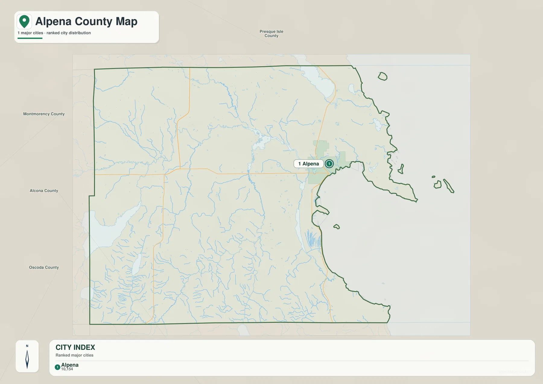
Alpena’s location is the important story on this map. The city is not near the geographic center of the county; it sits close to the eastern shoreline. Much of the county stretches west and southwest from that urban center without another city point of similar rank on this simplified layer.
That eastern position explains why roads from Alpena fan out in several directions on the reference map. US-23 stays near the Lake Huron side, while M-32 heads directly into the interior. The city map makes that relationship easier to recognize because minor roads, small communities, and terrain shading are reduced.
This map is not a complete settlement map. Smaller communities and local place names that appear on more detailed mapping may be absent from the ranked city layer. Use the county reference map when the goal is to find a smaller place, road, or intersection; use the city map when the goal is to show where the main urban reference point sits within the county.
For teaching or presentation work, a useful sequence is to start with the city map, then move to the county reference map, and finally compare the water map. That order shows Alpena’s coastal position first, then the road connections, and finally the Thunder Bay River system that approaches the city from inland.
Thunder Bay River, inland lakes, and the Lake Huron shore
The terrain-and-water map reveals a dense network of rivers, branches, ponds, and lakes. The Thunder Bay River is the dominant named river system in the county, with the North Branch Thunder Bay River entering from the northwest and the main channel crossing the central-eastern area toward Alpena and Thunder Bay. Smaller streams feed these channels from several directions.
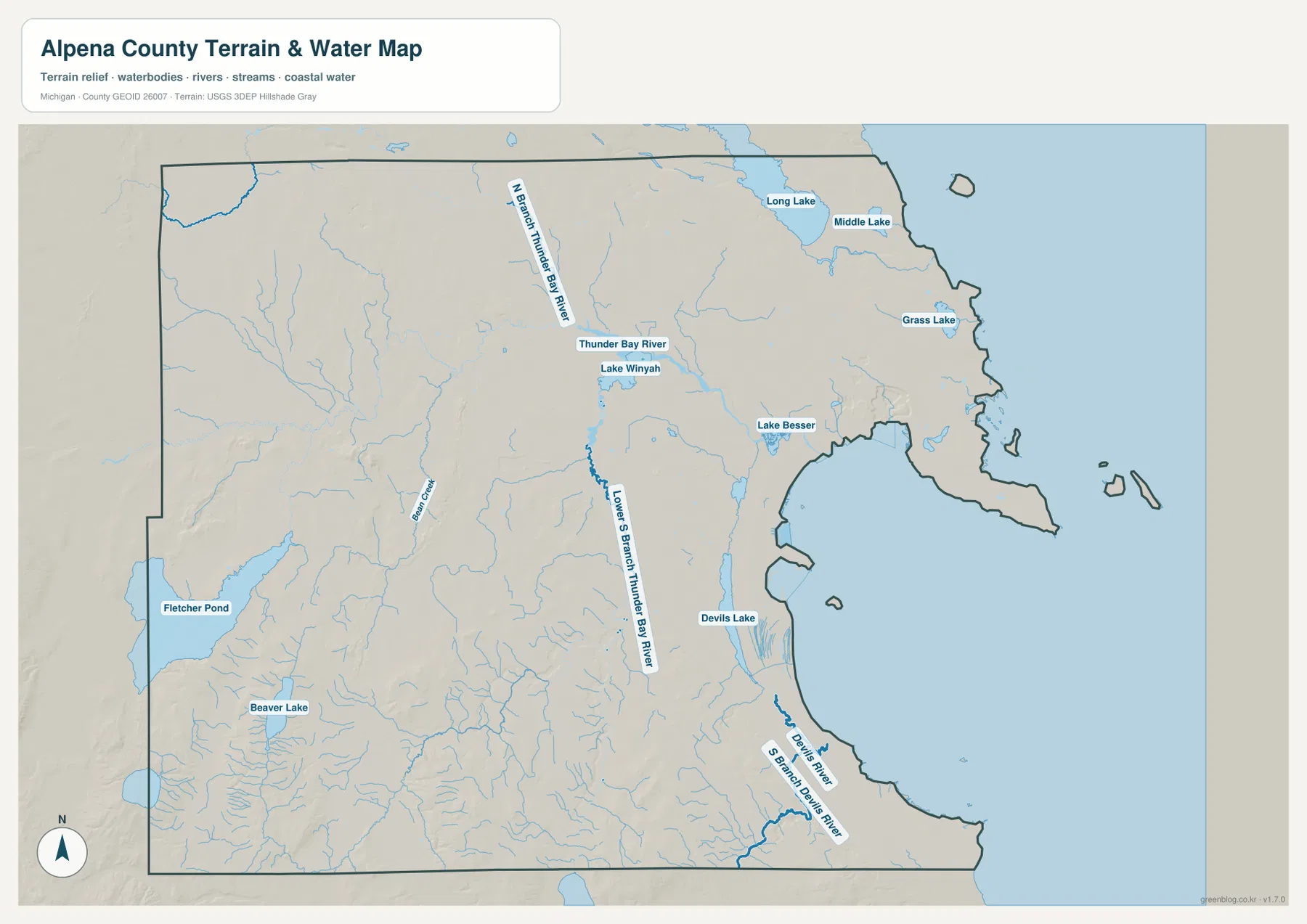
Long Lake is a major landmark along the northern edge of the map, with Middle Lake shown nearby. Farther east, Grass Lake appears close to the Lake Huron side. These inland waters make the northern part of the county easy to recognize even when road labels are removed.
Near the central part of the county, Lake Winyah and Lake Besser appear along the Thunder Bay River corridor. They sit close to the river rather than functioning as isolated features on the map. Their placement helps show how open water and river channels break up the inland landscape before the system reaches Thunder Bay.
Fletcher Pond is the largest named inland water body shown in the southwest portion of the map. Numerous smaller streams approach the pond and nearby low ground. Beaver Lake lies farther south, adding another clear water landmark to the western interior.
The southeastern shore has a different set of water features. Devils Lake is shown inland from the coast, while Devils River and South Branch Devils River continue toward Lake Huron. These streams demonstrate that not every part of the county drains through the main Thunder Bay River channel.
The map also labels Bulls Creek and many unnamed or smaller tributaries. Thin blue lines should not be interpreted as equal in size or flow to the larger named rivers. The purpose here is to show where water courses and water bodies are located, not to provide discharge, depth, water-quality, or navigation information.
Anyone using the area for boating, fishing, flood planning, or other safety-sensitive activities should consult current state and federal sources. Water levels, access rules, channel conditions, and flood risk can change and are not represented by this general map.
Low Lake Huron terrain and higher western hills
The elevation map removes most labels so the height differences stand out. Its legend reports an actual elevation range of about 133 to 335 meters and a mean of 222 meters. Darker green represents lower ground, lighter green and yellow represent middle elevations, and brown shades mark the higher parts of the county.
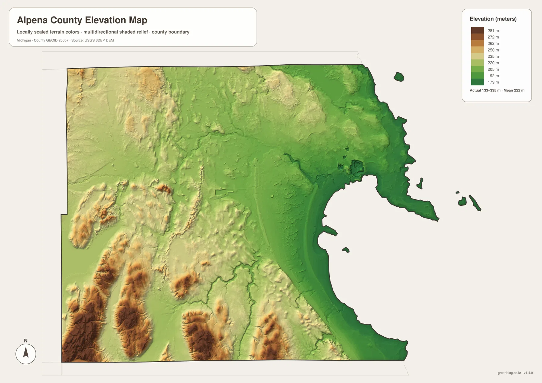
The lowest broad area follows the Lake Huron coast and Thunder Bay. Alpena sits within this lower eastern zone. From the shoreline, the colors generally become lighter toward the interior, although river valleys create narrow low areas that extend westward.
The most prominent high ground appears in the west and southwest. Several elongated brown and tan hills rise above the surrounding green terrain, with lower valleys separating them. This is one of the clearest contrasts on the map and helps explain why the western interior looks different from the Alpena shoreline area.
The northwest and central interior contain gentler changes. Those areas are not as dark green as the shoreline and not as strongly brown as the highest southwestern hills. The result is a gradual transition interrupted by valleys associated with the county’s river network.
Comparing this map with the terrain-and-water map is particularly useful. Many blue stream corridors on the water map correspond with lower green passages on the elevation map. The comparison makes it easier to see how water follows lower ground without requiring technical terrain analysis.
Similar colors do not mean every location has exactly the same elevation, and the shaded relief is not a substitute for surveyed heights. The map is intended for county-scale comparison. Engineering, construction, drainage design, and other precision work should rely on source elevation data and site-specific measurements.
Which Alpena County map fits the task?
Use the county reference map when roads, the county boundary, and the relationship between Alpena and the interior matter most. It gives the clearest overview of US-23, M-32, M-65, the coastal side, and the local road network. It works well as a general orientation map before switching to a more specialized view.
Use the major-city map when the goal is to communicate the position of Alpena quickly. With most other detail removed, the map shows how strongly the county’s main urban point is tied to Thunder Bay and the eastern edge. It is less useful for small communities or local-road research.
Choose the terrain-and-water map for rivers, lakes, and the shape of the Lake Huron shore. Thunder Bay River, North Branch Thunder Bay River, Long Lake, Fletcher Pond, Beaver Lake, Lake Besser, Lake Winyah, and the southeastern river system are much easier to compare on this layer than on the road map.
Choose the elevation map when the question is about the contrast between the low eastern shore and the higher western interior. It is also useful for seeing the lower river corridors that cut through the hills. Pairing it with the water map gives a clearer picture of how terrain and drainage relate across the county.
The WebP images on this page are intended for fast viewing in a browser. For a larger copy suitable for printing, slides, or classroom materials, use the ZIP below. It contains the original high-resolution JPG versions of all four maps described here.
Frequently Asked Questions
Which map is best for US-23, M-32, and M-65?
The county reference map is the best choice. It shows Alpena, the Lake Huron side, US-23, the east-west M-32 corridor, and M-65 in the western part of the county on the same image. Use current navigation or Michigan transportation information for live driving conditions.
Which map shows Thunder Bay River, Long Lake, and Fletcher Pond most clearly?
The terrain-and-water map is the clearest option because rivers and lakes are emphasized in blue while most road detail is reduced. It also shows the North Branch Thunder Bay River, Lake Besser, Lake Winyah, Beaver Lake, and smaller streams. It is not a depth, flood-risk, or navigation chart.
Where is the higher ground in Alpena County?
The elevation map shows lower terrain along Lake Huron and Thunder Bay, with higher hills concentrated in the west and especially the southwest. The legend reports an actual range of roughly 133 to 335 meters. Precise elevations for a specific site should be checked against USGS source data or a survey.
Map File Information
The ZIP contains the original high-resolution JPG files for the Alpena County reference map, major-city map, terrain-and-water map, and elevation map shown on this page.
- Included Files: county reference map, major-city map, terrain-and-water map, elevation map
- File Type: JPG
Related Maps
Sources and reference links
County services and local information are available from the official Alpena County website, and the county also maintains a Location and Maps page. For source datasets, see U.S. Census Bureau TIGER/Line for geographic boundaries, USGS National Hydrography for water features, and the USGS 3D Elevation Program for elevation data. These maps are for general reference and download use, not for legal boundaries, surveying, navigation, or flood determinations.
Green Map creates custom-edited map images using open geographic data sources such as geoBoundaries, Natural Earth, OpenStreetMap, and government open data. These maps are edited visual materials, not raw data files, and are provided for education, documents, presentations, and graphic reference.