Berkshire County occupies the long western edge of Massachusetts, and its shape makes more sense when roads, valleys, rivers, and mountain relief are considered together. Pittsfield sits near the middle of the county, while North Adams and Williamstown form strong northern reference points and Lee, Housatonic, and the southern road network extend far toward the Connecticut line. Rather than spreading across one broad plain, many named places and routes occupy corridors between ridges, so a map that shows only town names misses an important part of the county’s geography.
This page provides a general county map, a simplified major-city distribution map, and a terrain-and-water reference map, with the same set available as downloadable high-resolution JPG files. The general map is best for matching Pittsfield with Routes 7, 20, 2, 9, 8, and Interstate 90. The city layer reduces the county to Pittsfield and North Adams for quick orientation, while the water layer adds the Housatonic and Hoosic rivers, Pontoosuc and Onota lakes, Cheshire Reservoir, smaller lakes, and the surrounding mountain relief.
Table of Contents
Pittsfield, the road network, and Berkshire County’s long north-south outline
Pittsfield is the easiest starting point on the general county map. Its label occupies a central position, and several routes spread outward from the surrounding area. To the north, Cheshire, Adams, North Adams, and Williamstown create a sequence of reference places leading toward the top of the county. South of Pittsfield, Lenox and Lee appear before the map continues through Housatonic and the much longer southern section. That arrangement makes Pittsfield a practical dividing point when readers want to separate the northern, central, and southern parts of Berkshire County.
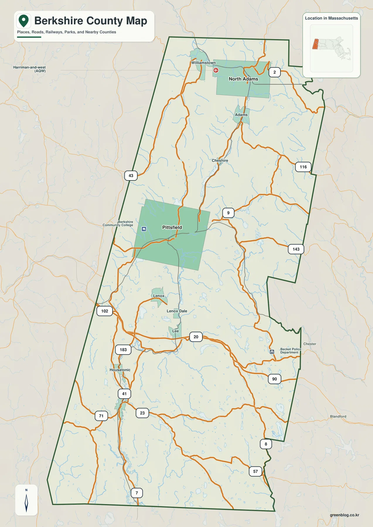
Route 7 is one of the clearest north-south references in the central and southern parts of the map. It enters from the south, follows the western side of the county’s interior corridor, and continues toward Pittsfield. Around Lee, Route 20 provides an important east-west reference, while Interstate 90 passes through the southeastern central section toward Becket. In the north, Route 2 crosses the North Adams area and provides a different east-west anchor. Using Route 7 for the south and center, Route 20 around Lee, and Route 2 in the north gives a simple framework before adding the smaller roads.
Several secondary routes help distinguish parts of the county that otherwise look similar at this scale. Route 9 extends east from the Pittsfield area, and Routes 116 and 143 appear in the northeastern interior. Route 8 follows a long corridor closer to the eastern side, while Routes 23 and 57 cross parts of the south. Routes 41 and 183 provide additional references near the Housatonic area. These roads are especially useful on an elongated county map because a place can be relatively close north-to-south but separated from another community by a ridge or a different valley corridor.
The boundary itself also deserves attention. Berkshire County is not a simple rectangle; the eastern edge steps inward and outward several times, and the northern and southern sections differ in width. Around Williamstown, North Adams, and Adams, named places are relatively close together. In the central and southern sections, longer gaps appear between some labels. The map therefore reads less like a single metropolitan area and more like a sequence of communities connected through mountain valleys and a limited set of through routes.
This general map is a regional reference rather than a live navigation product. Route numbers are useful for orientation, but construction, closures, seasonal conditions, and travel times can change. For a printed county overview, however, the map is effective because the major road framework can be explained without showing every local street. Pittsfield, Route 7, Route 20, Route 2, and Interstate 90 provide enough anchors for most readers to understand the broad transportation pattern.
What the Pittsfield and North Adams city ranking shows
The city-distribution layer is intentionally much simpler than the general map. It marks Pittsfield as number 1 and North Adams as number 2, and the CITY INDEX at the bottom repeats the same ordering. Values of 43,457 and 12,606 appear with the two labels, but they should be treated as the figures used by this specific ranking layer rather than as a substitute for a current official population table. The purpose of the graphic is to show which two cities were selected and where they sit within the long county outline.
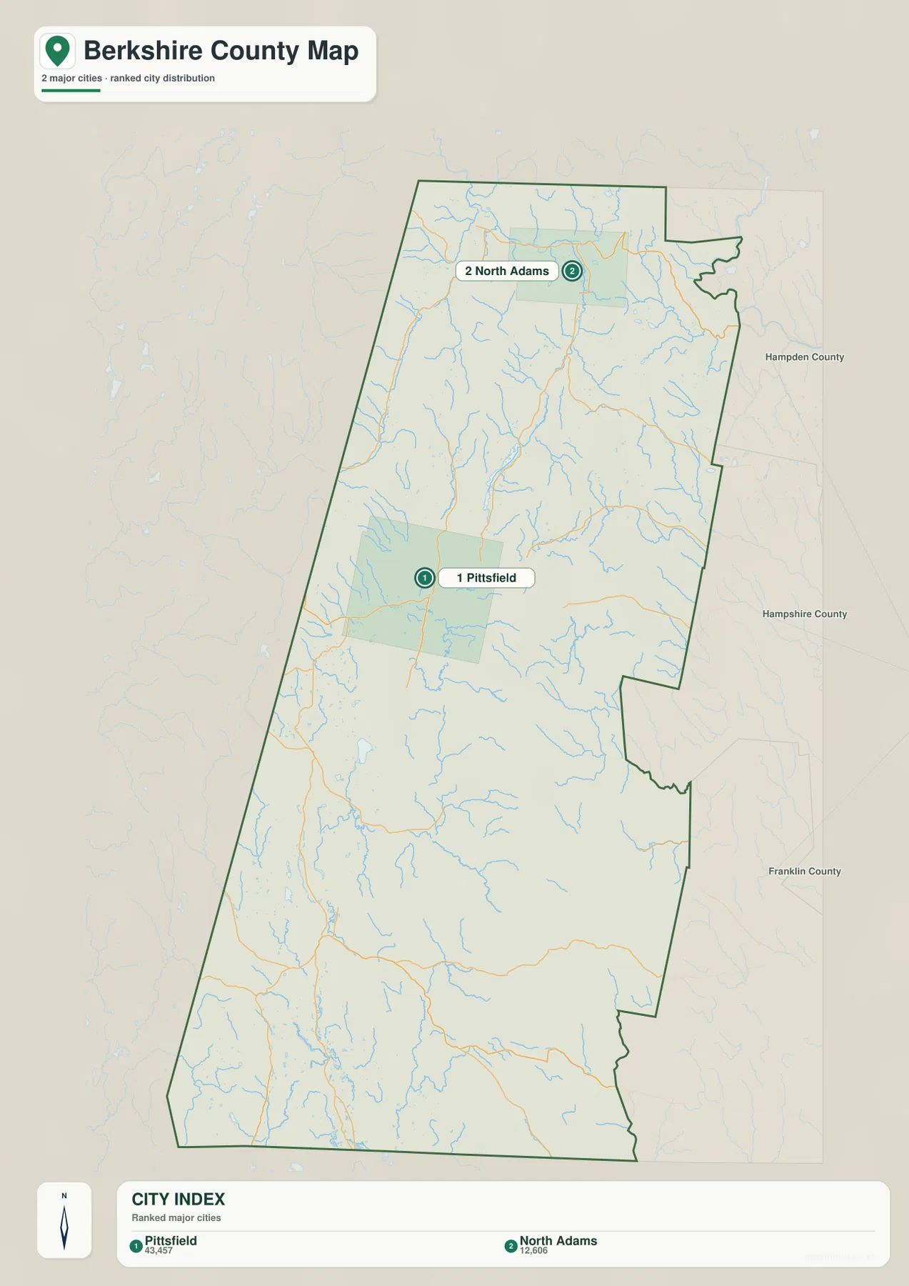
The separation between the two markers is informative. Pittsfield is near the middle of the county and slightly toward the western side, while North Adams lies much closer to the northern boundary. Returning to the general map fills in the gap: Cheshire and Adams appear between the Pittsfield area and North Adams, and the road network narrows into the northern valley corridor. The city layer is therefore useful as a first glance, with the general map providing the intermediate communities and routes that explain how the two urban points are connected.
It would be misleading to read this graphic as a complete municipal map. The Berkshire Regional Planning Commission states that all 32 municipalities that comprise Berkshire County are members of the commission. The general map itself names several places beyond the two ranked cities, including Williamstown, Adams, Cheshire, Lenox, Lee, and Housatonic. The city layer should be understood as a selective ranking map, not as an inventory of every city, town, village, or municipal boundary in the county.
Using Pittsfield and North Adams as fixed points can still simplify regional comparisons. Pittsfield works well as the central anchor for Routes 7 and 9 and for nearby lakes, while North Adams connects the northern road map to the Hoosic River valley. Southern communities such as Lee and Housatonic form another geographic zone not represented by a ranked city marker. For that reason, the three supplied maps are most useful when read together rather than treating the city index as the complete story.
Housatonic River, Hoosic River, lakes, and the mountain relief around them
The terrain-and-water map explains much of the pattern visible on the road map. Shaded relief is strong along both sides of the county and across the north, while larger blue river lines tend to occupy lower corridors between those ridges. The Housatonic River is the dominant named waterway through the central and southern portion of the map. Farther north, the Hoosic River forms a separate major corridor. The result is a county in which roads, settlements, lakes, and rivers often align with valleys rather than following a simple grid.
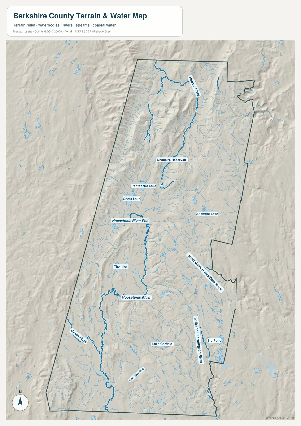
The Pittsfield area provides a good example of how water and settlement relate. Pontoosuc Lake and Onota Lake sit close to the city, and Cheshire Reservoir extends farther north. Housatonic River Pond and The Inlet are labeled in the central portion before the Housatonic River continues south through the county. On a road-only view, Pittsfield may appear to be simply a central city at a road junction. On the terrain-and-water map, it becomes much clearer that the city and its nearby lakes occupy a lower corridor framed by higher terrain.
Southern Berkshire County adds several other named waters. The Green River and Konkapot River appear in the south and southwest, Lake Garfield lies in the southern interior, and Big Pond is shown toward the southeast. The eastern side also includes the West Branch Westfield River, with the West Branch Farmington River farther south. Those labels are important because they show that not every stream in the county belongs to the same drainage path. Ridges divide neighboring headwaters, sending water toward different river systems despite the relatively narrow county width.
The northern relief is also significant. The water map does not label Mount Greylock directly, but Massachusetts’ official Mount Greylock State Reservation page identifies the 3,491-foot summit in Lanesborough as the highest point in the state. That official context helps explain the strong mountain shading around the north-central portion of the county and the narrow valleys around Adams and North Adams. Readers should not use the relief shading to calculate exact elevation, but it is very effective for seeing why the northern road and river corridors are concentrated in certain locations.
The Housatonic is much larger than the Berkshire County segment shown here. The U.S. Environmental Protection Agency describes a river of roughly 150 miles from headwaters on the East Branch in Hinsdale, Massachusetts, through Connecticut to Long Island Sound. This map focuses on the Berkshire portion, where the river links the Pittsfield area with communities farther south. It is therefore appropriate for county orientation, but not a replacement for a full watershed map covering the river’s entire downstream course.
The blue features and terrain shading should also be interpreted at the correct scale. They do not define flood zones, navigable channels, wetland jurisdiction, parcel boundaries, engineering elevations, or safe boating areas. The map is most useful for comparing which lakes and rivers lie near Pittsfield, how the Hoosic corridor differs from the Housatonic corridor, and how the major waterways occupy valleys between visible ridges. Specialized regulatory, hazard, and engineering questions require the corresponding official datasets.
Dividing Berkshire County into northern, central, and southern reference zones
Because the county is so tall on the page, dividing it into three reference zones makes the maps easier to use. In the north, Williamstown, North Adams, Adams, Route 2, and the Hoosic River are the strongest names to remember. Moving south brings the viewer through Cheshire and into Pittsfield. This northern sequence is compact enough that the city and road labels feel relatively close together, but the relief map shows that the corridor is still constrained by substantial mountain terrain.
The central zone is organized around Pittsfield and nearby lakes. Route 7 and Route 9 create the principal road references, while Pontoosuc and Onota lakes help orient the western side of the city. South and southeast of Pittsfield, Lenox and Lee lead into the Route 20 and Interstate 90 corridor. Compared with the north, this section has more intersecting routes, yet the terrain prevents the pattern from becoming a broad, uniform street grid.
In the south, Housatonic and Route 7 provide useful starting points, with Routes 23, 41, and 183 adding local orientation. Route 8 and Route 57 become more relevant toward the eastern side. The water map adds the Green River, Konkapot River, Lake Garfield, West Branch Farmington River, and Big Pond, demonstrating that southern Berkshire County contains several distinct drainage directions. That variety is one reason a terrain-and-water layer is more informative here than a simple map of major towns.
This three-zone method also helps with presentations or classroom use. Start with the general map to establish the route network, switch to the city layer for the relative positions of Pittsfield and North Adams, and then use the terrain-and-water layer to explain why roads and communities occupy particular valleys. Because all three maps use the same county outline, readers can move between them without having to relearn the geographic frame.
Choosing the right Berkshire County file for print, classwork, or regional reference
For a general regional handout, the county map is the most versatile choice. It includes the longest list of named places and the clearest road context, so a reader can move from Williamstown and North Adams through Pittsfield to Lee and Housatonic without switching layers. If the page is becoming visually crowded, focus on Route 7, Route 20, Route 2, and Interstate 90 rather than trying to explain every numbered road at once.
The city map is better when only a simple central-versus-northern comparison is needed. Pittsfield and North Adams stand out immediately because most other labels have been removed. It should not be used when the assignment requires all 32 municipalities or municipal boundaries. For a discussion of rivers, lakes, or mountain valleys, the terrain-and-water layer is the stronger choice because it connects the Housatonic and Hoosic systems with lakes and shaded relief that are largely absent from the simplified city view.
The downloadable JPG files are suitable for screen reference, printing, presentations, and non-survey regional comparison. They are not legal boundary documents, live road maps, flood determinations, or engineering elevation products. When a project depends on exact boundaries, current transportation status, water management, or official measurements, the Census Bureau, Massachusetts agencies, USGS, EPA, or the relevant local authority should be used for the authoritative source.
Frequently Asked Questions
Why does the city map show only Pittsfield and North Adams?
The supplied city layer is a selective ranking map rather than a complete municipal map. It highlights two major-city points for quick orientation. Berkshire Regional Planning Commission describes 32 municipalities in the county, so use broader municipal or administrative sources when a complete list or exact town boundaries are required.
Which map is best for following the Housatonic River through Berkshire County?
The terrain-and-water reference map is the best match because it shows the Housatonic as a major blue river line together with nearby lakes, tributaries, and shaded mountain relief. It is a geographic reference, not a flood, navigation, water-quality, or regulatory map, so specialized river questions should use the appropriate official agency data.
Which roads are easiest to use for north-south orientation?
Route 7 is one of the clearest references through the southern and central parts of the county. Around Lee, Route 20 and Interstate 90 help establish the east-west corridor, while Route 2 is especially useful around North Adams in the north. Check current transportation sources for actual driving conditions, closures, and travel times.
Map File Information
The ZIP contains the original high-resolution JPG versions of the general county map, major-city distribution map, and terrain-and-water reference map discussed on this page.
- Included Files: general county map, major-city distribution map, terrain-and-water reference map
- File Type: JPG
Related Maps
Sources and references
These public and official resources provide additional context for Berkshire County’s municipalities, mountain terrain, Housatonic River, boundaries, and hydrography.
- Berkshire Regional Planning Commission – About
- Mass.gov – Mount Greylock State Reservation
- U.S. EPA – Cleaning up the Housatonic
- U.S. Census Bureau TIGER/Line Shapefiles
- USGS National Hydrography
Green Map creates custom-edited map images using open geographic data sources such as geoBoundaries, Natural Earth, OpenStreetMap, and government open data. These maps are edited visual materials, not raw data files, and are provided for education, documents, presentations, and graphic reference.