Wicomico County sits on Maryland’s Eastern Shore, where Salisbury forms the most prominent urban center and the road network spreads toward smaller communities in several directions. US 50 runs east and west through the middle of the county, while US 13 provides the main north-south reference through Salisbury and Fruitland. The county also has a strong water-based geography: the Nanticoke River frames much of the western side, the Wicomico River reaches the southwest, and the Pocomoke River system appears near the eastern edge. High-resolution map files are available for download in the section below.
The maps on this page can be downloaded as high-resolution JPG files. Rather than treating them as four versions of the same picture, it is more useful to read them as separate layers of local information: the county map emphasizes roads and places, the city map simplifies settlement locations, the water map brings streams and ponds forward, and the elevation map shows subtle changes in relief across this low-lying part of the Delmarva Peninsula. Together they make it easier to compare where people, routes, waterways, and slightly higher ground occur within the same boundary.
Table of Contents
Salisbury as the road hub between the western and eastern sides
On the general county map, Salisbury is the clearest organizing point. US 50 crosses the county through Salisbury and continues east toward Pittsville and Willards, while US 13 runs through the Salisbury area and south toward Fruitland. Delmar lies on the northern edge near the Maryland-Delaware line, Hebron is west of Salisbury, and the smaller communities of Pittsville and Willards sit farther east. Using those place names with the numbered highways gives a quick sense of orientation without needing a dense street-level map.
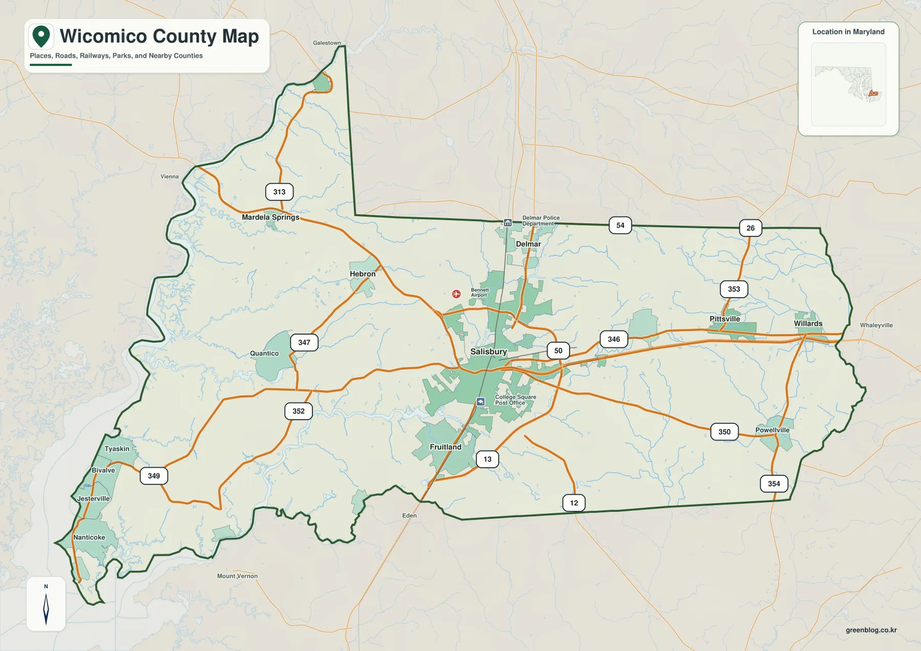
The shape of the county is noticeably different on its western and eastern sides. The west is irregular, with the boundary following river and lowland features in places, while the east and south include longer stretches of comparatively simple boundary line. Dorchester County, Somerset County, and Worcester County are labeled outside the boundary, which helps place Wicomico within the Lower Eastern Shore. The northern edge also reaches the Delaware state line around Delmar, so the county map is useful for understanding both local travel and the broader state-border setting.
Several Maryland routes add detail to the US highway framework. Roads numbered 54, 26, 353, 346, 350, 354, 347, 352, 349, and 313 appear in different parts of the county. A visitor does not need to memorize them all; a practical method is to start with US 50 and US 13, then identify the smaller route nearest the destination. This is especially helpful west of Salisbury, where roads and creeks create a more intricate pattern, and east of the city, where the US 50 corridor provides a strong east-west reference toward Pittsville and Willards.
How the main communities are arranged around Salisbury
The city map strips away much of the road detail and makes the settlement pattern easier to compare. Salisbury is ranked first on the map and sits near the center of the county’s populated core. Fruitland is close to its south, Delmar is positioned near the northern boundary, Hebron lies to the west, and Pittsville and Willards form a pair of eastern reference points. This arrangement shows why Salisbury works so well as the starting point when reading any of the other maps: most of the labeled communities can be located by describing their direction from it.
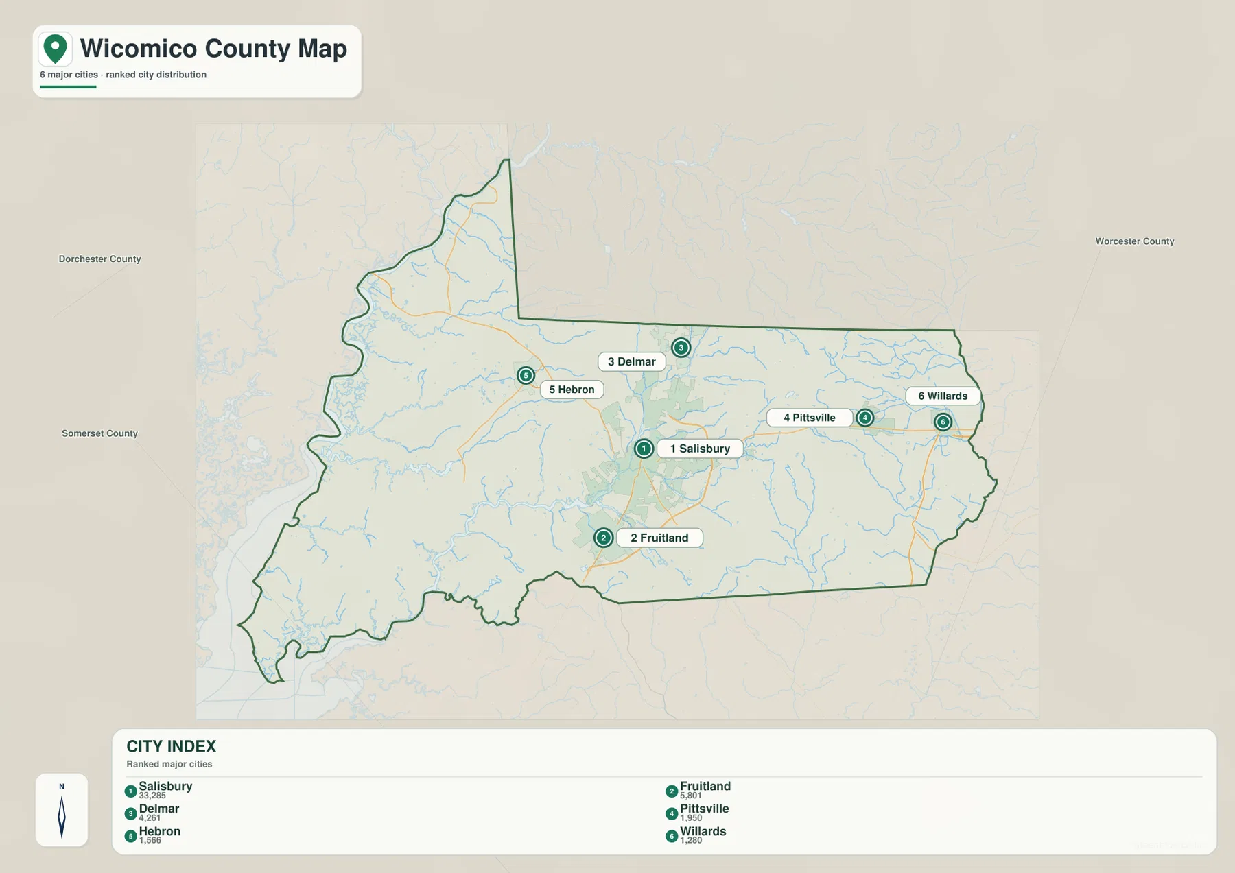
Salisbury and Fruitland appear close together, but the other labeled communities are more widely separated. Delmar is useful as a northern anchor, Hebron marks the western interior, and Pittsville and Willards help divide the eastern side into recognizable points. When this city map is paired with the general map, the simplified dots can be translated into actual route choices: US 13 is the obvious reference toward Fruitland, US 50 is the main reference toward the eastern communities, and the western side requires more attention to secondary roads.
This map should not be read as a municipal-boundary or travel-time product. Its strength is clarity. It helps a student, traveler, or researcher quickly locate the principal named communities before moving to a map with more detail. It is also useful for comparing which places are close to the county’s central road junctions and which sit near an outer edge. That distinction becomes important when the water and elevation maps are added, because the western and southwestern communities are closer to the large river systems and lower terrain.
Nanticoke and Wicomico river corridors with a dense network of creeks
The water map changes the emphasis completely. Along the western side, the Nanticoke River forms the strongest water feature and follows a broad, winding course beside the county. The Wicomico River appears in the southwest, where the county opens toward larger tidal waters. Inland, Quantico Creek and Rewastico Creek extend through the western half, linking smaller drainage lines to the larger river system. These waterways explain why the western boundary looks more complicated on the county map than the long straight sections seen elsewhere.
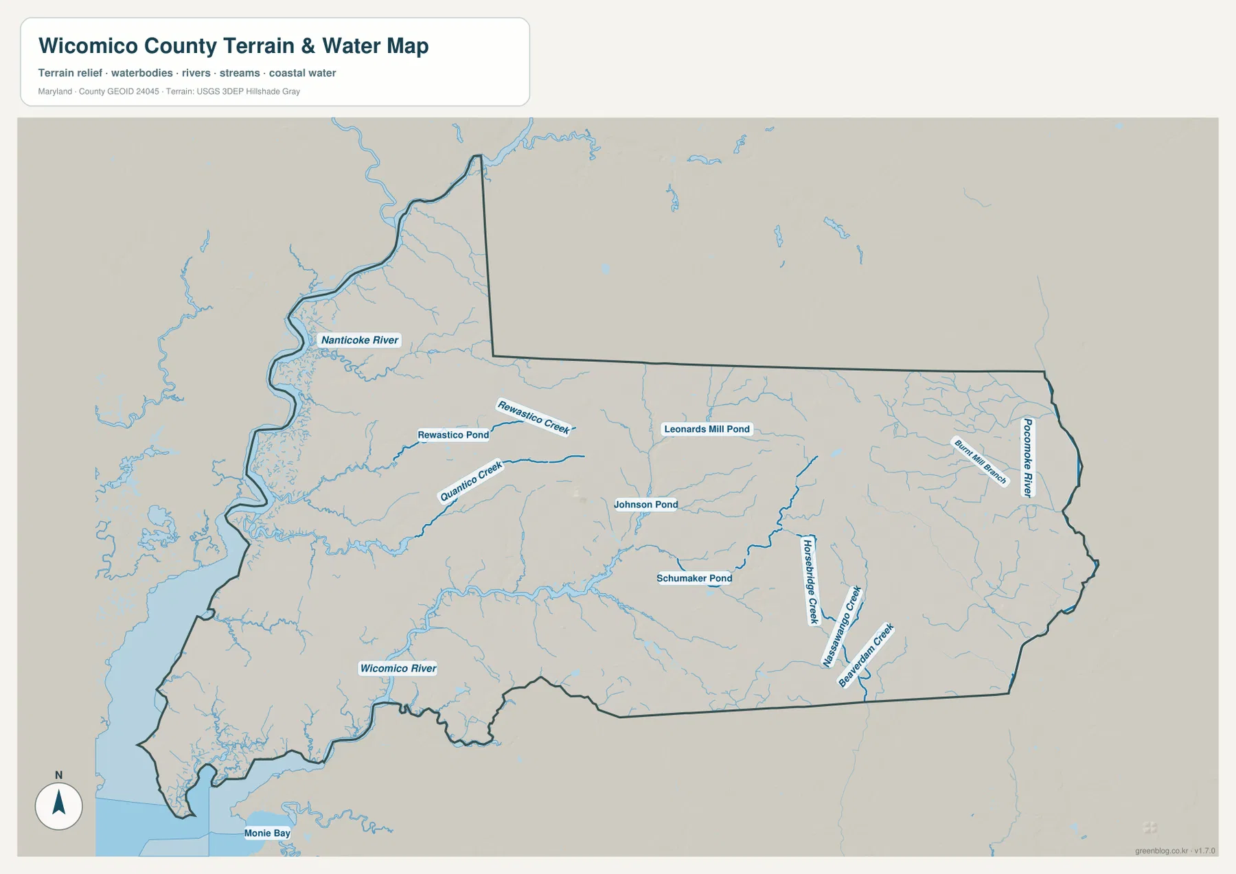
The central and eastern parts of Wicomico show a different mix of water features. Johnson Pond, Schumaker Pond, and Leonards Mill Pond are labeled as compact water bodies, while Horsebridge Creek and Beaverdam Creek run through the southeastern side. Near the eastern edge, the Pocomoke River system gives the county another major drainage reference. The map therefore shows that Wicomico is not organized around a single river: western streams, southern tidal waters, and eastern tributaries belong to different local drainage patterns.
For map reading, this water layer is most useful when it is compared with the city map. Salisbury is surrounded by smaller streams, while the broadest river corridors are farther west and southwest. That difference can help explain why the county’s road and settlement patterns look more open in some places and more broken up by water in others. The map is not a flood-hazard, wetland-regulation, depth, navigation, or property-boundary product. Those questions require separate official datasets. Here, the goal is to understand where the principal rivers, creeks, ponds, and coastal water features sit in relation to the county as a whole.
Low Eastern Shore relief with a slightly higher east-central zone
Wicomico County is generally low and gently rolling rather than mountainous, so the elevation map uses a local color scale to make small differences visible. The lowest-looking colors spread across much of the west and southwest, especially near the Nanticoke and Wicomico river corridors. Moving into the east-central portion of the county, warmer colors become more common and form a noticeable elongated zone of relatively higher ground. Narrow stream valleys cut through that higher area as lower-colored lines.
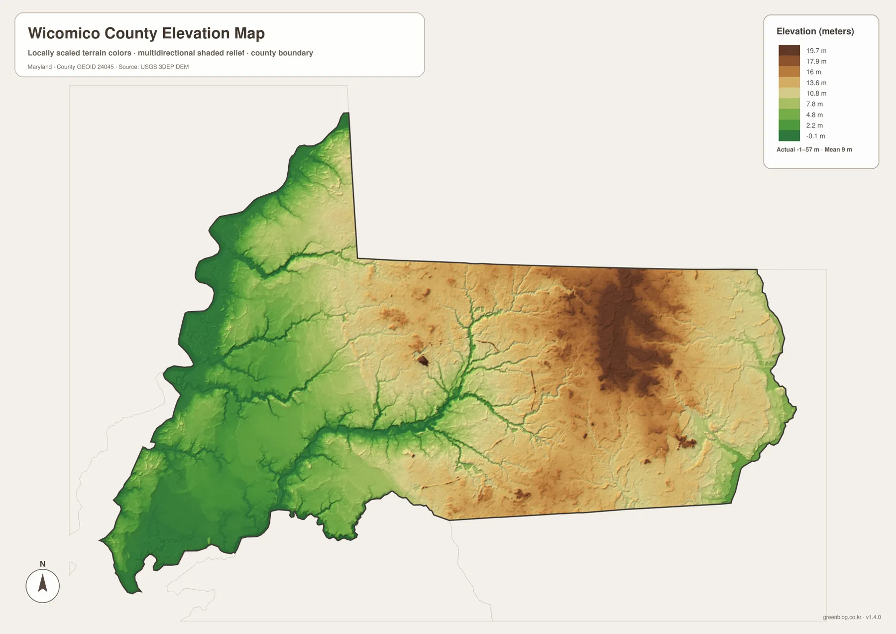
The strong color contrast can look more dramatic than the actual relief. Brown areas on this locally scaled map are not mountain ridges in the sense found in western Maryland. They indicate land that is higher relative to the county’s lower river corridors. This is why the elevation map is best read alongside the water map. The lowest tones tend to follow broad drainage areas and stream channels, while slightly higher surfaces occupy the spaces between them. That relationship is more informative than focusing on one color as if it represented a steep landform.
For engineering, construction, surveying, or parcel-level drainage work, a generalized map like this is not precise enough. Exact elevations should be checked against source elevation data and site-specific measurements. For ordinary geographic reference, however, the map makes an important point: Wicomico’s topography is subtle but not perfectly flat. The transition from low western river country to higher east-central surfaces helps explain the fine branching of streams and gives useful context to the placement of roads and communities.
Choosing the most useful map for a specific task
If the goal is basic orientation, the general county map is the strongest starting point because it combines the boundary, communities, major routes, and surrounding context. A reader can find Salisbury first, use US 50 and US 13 as the main axes, and then work outward toward Hebron, Delmar, Fruitland, Pittsville, or Willards. The city map is better when road detail is distracting and the main question is simply where the named communities sit relative to one another.
For environmental or landscape context, the water and elevation maps are more revealing. The water map separates the Nanticoke, Wicomico, and Pocomoke systems and labels several creeks and ponds, while the elevation map shows how lower river corridors contrast with slightly higher land farther east. Used together, they help explain the western county’s irregular shape and the branching drainage lines that cross the interior. Neither should be treated as a regulatory, legal, or engineering map, but both are useful for a broad geographic overview.
For teaching or presentation work, choosing one map for one question usually produces a clearer page than forcing all information into a single graphic. Use the county map for transportation and place names, the city map for settlement pattern, the water map for rivers and tributaries, and the elevation map for relative relief. Because all four share the same county outline, a feature found in one image can be compared with the same part of the county in another. That makes the set especially useful for explaining why Salisbury is a central road hub while the western and southwestern sides are shaped more strongly by water.
When printing, check that the labels remain legible after scaling the page. On a screen, zooming into one section at a time is often the easiest way to read secondary road numbers and smaller water names. These maps are reference graphics rather than live navigation products, so current closures, turn restrictions, and travel times should be checked with up-to-date transportation sources. Their main value is that they give a consistent visual framework for comparing Wicomico County’s communities, roads, waterways, and terrain.
Frequently Asked Questions
Which map is best for finding Salisbury and the main highways?
Start with the general county map. It shows Salisbury together with US 50 and US 13, and it also places Fruitland, Delmar, Hebron, Pittsville, and Willards in the same frame. If you only need the relative positions of the communities, the city map is simpler; you can then return to the county map to identify the actual highway connection.
Can the Nanticoke River and Wicomico River be viewed on the same map?
Yes. The water map shows the Nanticoke River along the western side and the Wicomico River in the southwest, along with Quantico Creek, Rewastico Creek, several ponds, and eastern tributaries. It is a geographic reference map, not a flood-risk, depth, navigation, or wetland-regulation map.
Do the brown colors on the elevation map represent mountains?
No. The map uses a locally scaled color range to make relatively small elevation differences easier to see. The east-central brown area is higher than the lower western river corridors, but Wicomico County remains a low-relief Eastern Shore landscape. Survey-grade or engineering elevations should be checked in the original elevation data and site-specific measurements.
Map File Information
The ZIP contains the original high-resolution JPG versions of the county, city, water, and elevation maps discussed on this page.
- Included Files: county map, city map, water map, elevation map
- File Type: JPG
Related Maps
Sources and references
The following official resources are useful for checking county information, roads, boundaries, hydrography, and elevation data used as geographic reference.
- Wicomico County, Maryland – Official Website
- U.S. Census Bureau TIGER/Line Shapefiles
- Maryland State Highway Administration – Wicomico County Highway Location Reference
- USGS National Hydrography
- USGS 3D Elevation Program
Green Map creates custom-edited map images using open geographic data sources such as geoBoundaries, Natural Earth, OpenStreetMap, and government open data. These maps are edited visual materials, not raw data files, and are provided for education, documents, presentations, and graphic reference.