Washington County stretches across western Maryland in a long east-west shape, with Hagerstown at the center of a broad valley and a narrow mountain corridor extending west to Hancock. Smithsburg sits near the higher eastern edge, while Boonsboro and Keedysville occupy the Antietam Creek side to the southeast and Williamsport provides a key reference southwest of Hagerstown. Roads, stream valleys, and long ridges create very different landscapes within one county. This page explains the settlement pattern, major highways, creeks, and elevation changes shown on the supplied maps, and matching high-resolution JPG files are available together in a downloadable ZIP archive.
Washington County Government lists nine municipalities: Hagerstown, Boonsboro, Clear Spring, Funkstown, Hancock, Keedysville, Sharpsburg, Smithsburg, and Williamsport. Official county material identifies Hagerstown as the county seat and describes the Hagerstown Valley as a fertile lowland between the Blue Ridge Mountains to the east and the Appalachian Highlands to the west. That geography is easy to recognize on the elevation map, where the broad central lowland is framed by much higher ridges.
Table of Contents
Hagerstown and the I-70/I-81 junction anchor the central valley
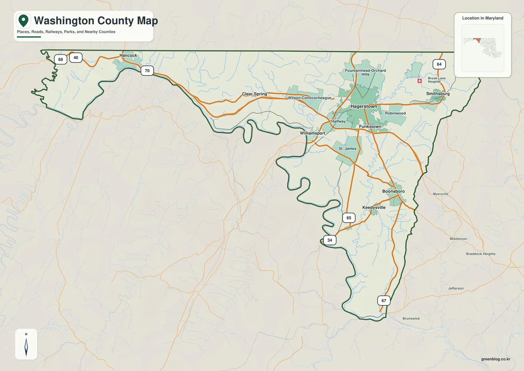
Hagerstown is the clearest starting point on the general county map. Halfway, Funkstown, Robinwood, and Fountainhead-Orchard Hills sit nearby, while I-70 crosses east-west and I-81 runs north-south. The two interstates give the central county a transportation pattern that is much more open than the narrow mountain corridors at either end.
Clear Spring lies west of Hagerstown, and Hancock sits much farther west near the end of the county’s narrow projection. I-70 and U.S. 40 are the strongest road references in that direction. As the map approaches Hancock, parallel ridges and valleys become more obvious and transportation is funneled through the lower gaps between them.
Williamsport sits southwest of Hagerstown with St. James nearby. This area combines the I-70/I-81 transportation network with lower ground toward the Potomac side. Small stream valleys cross what otherwise looks like a broad open valley, a detail that becomes much clearer on the terrain-water map.
The general map is intended for geographic orientation rather than live traffic. Construction, incidents, closures, and current travel time on I-70 and I-81 are not shown. Actual trips should use current Maryland transportation information and navigation services.
Smithsburg, Boonsboro, and Keedysville sit where valley roads meet higher terrain
Smithsburg lies near the higher eastern edge of the county, with MD 64 providing an important road reference. East of Hagerstown, the broad central valley narrows toward the mountain boundary. Myersville, Middletown, and Brunswick appear outside the county as useful Frederick County references on the opposite side.
Boonsboro and Keedysville occupy the southeastern section, where MD 65, MD 34, and MD 67 help organize the road network. Boonsboro sits between the higher eastern terrain and the Antietam Creek corridor, while Keedysville lies farther southwest near the lower valley. Roads curve more around ridges and streams here than they do across the open Hagerstown floor.
Sharpsburg does not appear among the six City Index markers, but it is one of the county’s nine municipalities and sits beside Antietam National Battlefield. The National Park Service places the battlefield about 10 miles south of Hagerstown in Washington County. Its location along Antietam Creek makes it a useful real-world reference for the southeastern water and terrain map.
Official county material describes Hagerstown Valley between the Blue Ridge and Appalachian Highlands. Even where the road map does not label every ridge, the pattern is apparent: cities and major highways concentrate in the lower center, while elevation increases sharply toward the eastern and western margins.
The City Index compares Hagerstown with five smaller towns across the county
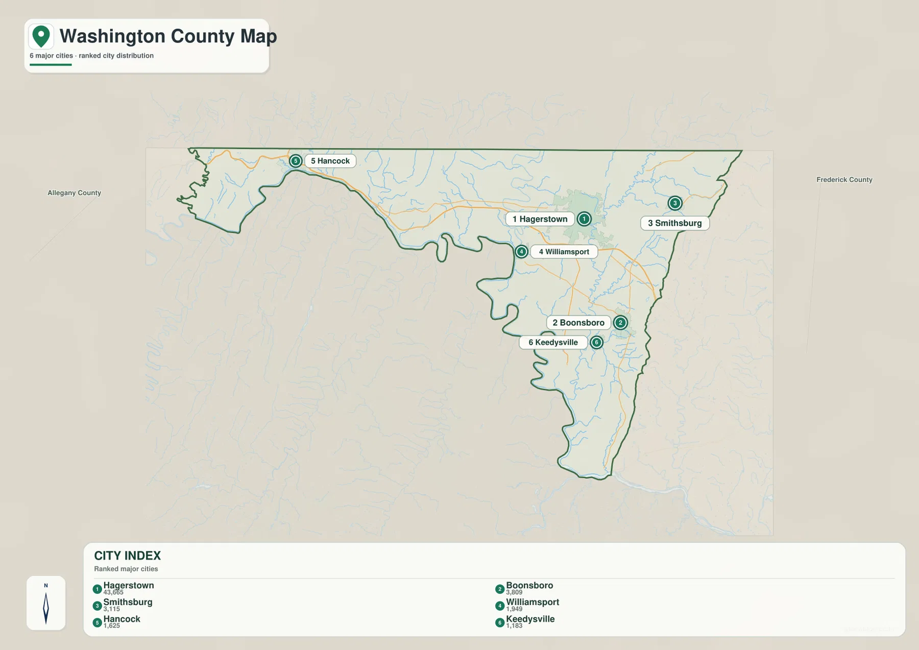
The City Index ranks Hagerstown, Boonsboro, Smithsburg, Williamsport, Hancock, and Keedysville. It prints the values 43,665 for Hagerstown, 3,809 for Boonsboro, 3,115 for Smithsburg, 1,949 for Williamsport, 1,625 for Hancock, and 1,183 for Keedysville. The graphic does not state a reference year or statistical definition, so these figures should not be presented as current population counts. Current values should come from the latest U.S. Census Bureau or municipal sources.
The spatial distribution is more useful than the ranking itself. Hagerstown sits in the broad central valley, Williamsport lies southwest, Smithsburg east, and Boonsboro and Keedysville southeast. Hancock is isolated far to the west, emphasizing the unusual elongated shape of Washington County.
The six-place index is not a complete municipal list. Washington County Government also lists Clear Spring, Funkstown, and Sharpsburg, bringing the total to nine municipalities. The City Index should therefore be read as a selected town comparison rather than an administrative directory.
No connector lines or mileage labels are shown between the six markers. The index cannot be used to calculate driving distance from Hagerstown to Hancock, Boonsboro, or Smithsburg. Use it for relative position and the general road map or current routing information for travel.
Antietam Creek and the Conococheague system divide the valley into smaller drainage corridors
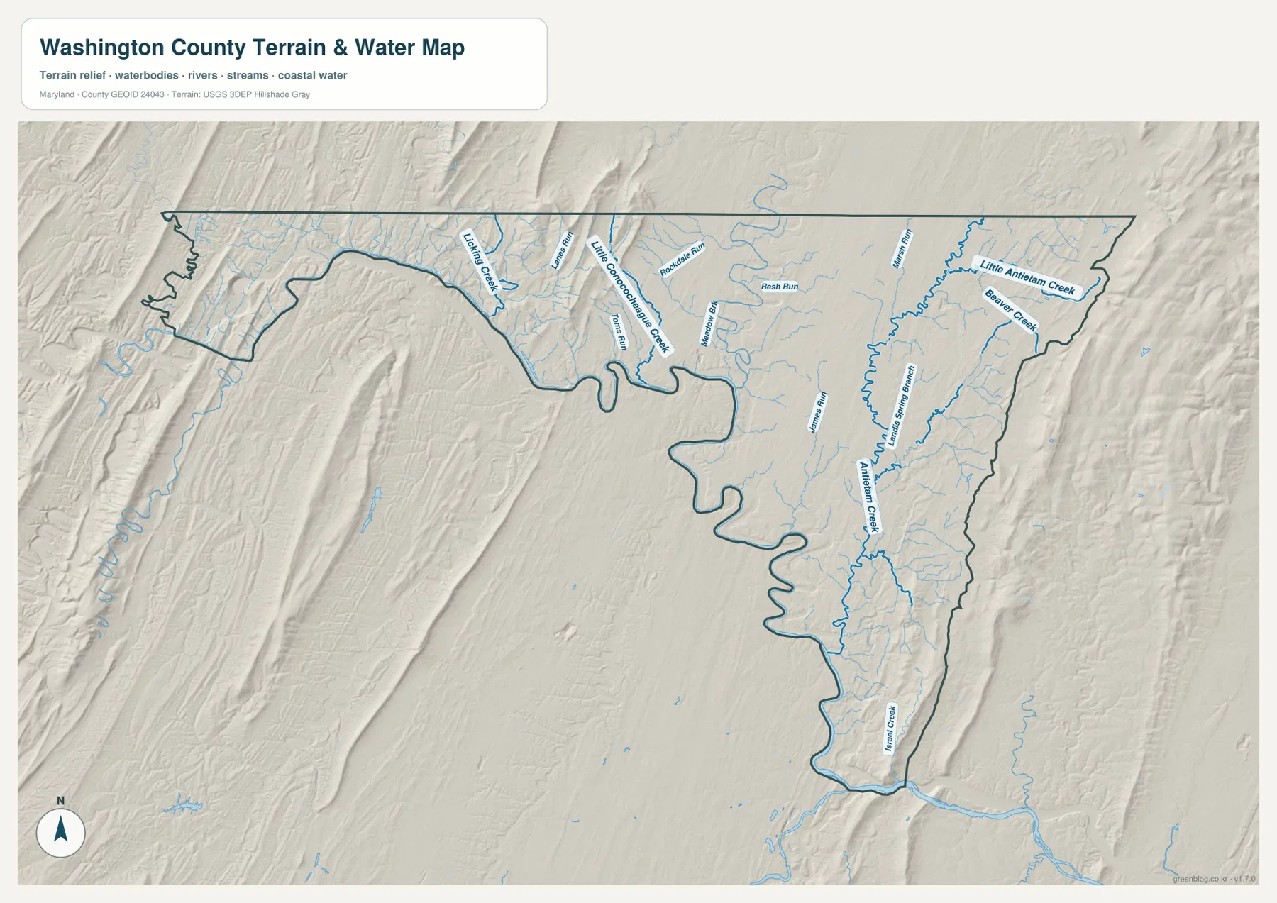
Antietam Creek is the strongest named waterway on the eastern side of the terrain-water map. It runs south through a long valley and receives Little Antietam Creek, Beaver Creek, and numerous smaller tributaries. The creek provides an important geographic reference for the Boonsboro-Keedysville-Sharpsburg side of the county.
Marsh Run and Lanes Spring Branch appear west of the Antietam corridor, with additional small channels crossing the Hagerstown Valley. Antietam National Battlefield sits near Sharpsburg along this same creek system, linking the map’s drainage pattern with a well-known landscape south of Hagerstown.
Farther west, Little Conococheague Creek is a major label, with Licking Creek, Toms Run, Rockdale Run, Rosh Run, and other tributaries crossing the mountain-and-valley terrain. As the county narrows toward Hancock, streams are increasingly confined by long ridges rather than spreading across a broad lowland.
The terrain-water graphic is a broad geographic reference, not a flood map, depth source, water-quality report, or legal water-boundary product. Flood, development, and stream-safety decisions require current USGS, FEMA, Maryland, and local information.
A 63–652 meter range separates the Hagerstown Valley from high ridges on both sides
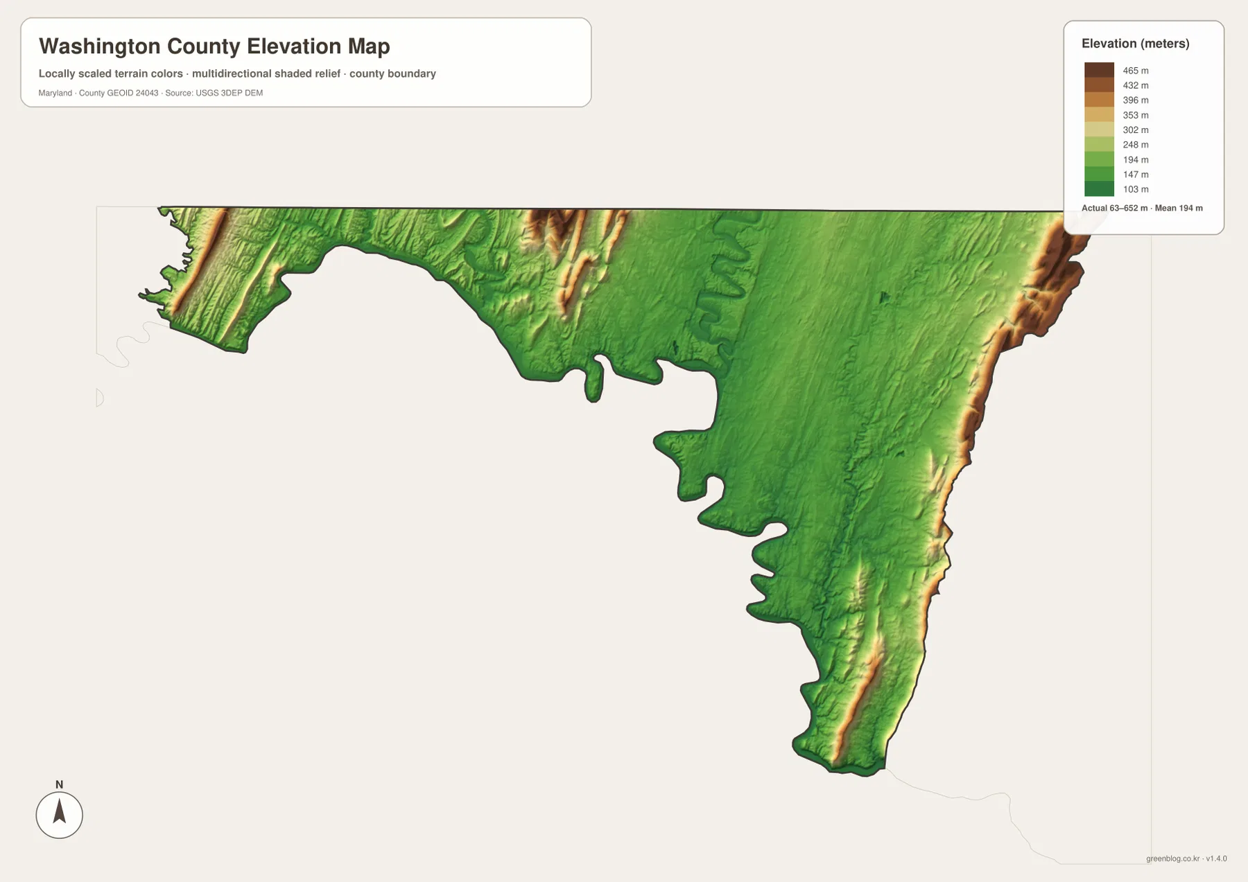
The elevation graphic reports an actual data range from 63 to 652 meters and a mean elevation of 194 meters. The broad Hagerstown Valley appears as a large green lowland in the center, while brown and tan ridges rise along the western Hancock corridor and the eastern county margin. This is a much stronger relief pattern than the low Coastal Plain counties farther east in Maryland.
The narrow western projection contains several long, parallel ridges and valleys. Between Hancock and Clear Spring, roads and streams occupy lower corridors while ridge tops rise sharply above them. Moving toward Hagerstown, the low green valley floor widens and provides far more room for settlement and major highway junctions.
Elevation rises again along the eastern boundary near Smithsburg and the Boonsboro side. Antietam Creek follows a lower valley west of the higher terrain, with small tributaries descending toward it. The contrast shows why Washington County is better understood as a central valley framed by mountain ridges than as one uniform upland.
The 63–652 meter range is the overall data range printed on the supplied elevation map, not an exact road, building, or parcel elevation. Engineering, surveying, drainage design, and flood-risk work require authoritative USGS elevation information, professional measurements, and current FEMA or local flood products.
Use the Hagerstown road network for orientation, then switch to the creek and elevation maps for the mountain margins
The general county map is the best starting point for Hagerstown, Williamsport, Clear Spring, I-70, and I-81. The City Index is cleaner when the goal is simply to compare Hagerstown with Boonsboro, Smithsburg, Hancock, Keedysville, and Williamsport. For natural geography, the water map highlights Antietam Creek and the western Conococheague tributaries, while the elevation map explains why the broad central valley differs so strongly from the ridges at both ends.
Antietam National Battlefield provides a useful local example of the southeastern landscape. The National Park Service places the roughly 3,000-acre battlefield near Sharpsburg, about 10 miles south of Hagerstown, along the Antietam Creek corridor. Comparing that location with the water and elevation maps makes the Boonsboro-Keedysville-Sharpsburg valley much easier to understand.
The downloadable originals are JPG files measuring 3638 × 2572 pixels each. They work well in landscape documents and can be enlarged around Hagerstown, Hancock, Boonsboro, Antietam Creek, or other areas for classroom material, presentations, and personal reference. Enlargement does not add live traffic, parcel boundaries, flood zones, water depth, or survey-grade elevation, so specialized decisions should always use current official data.
Frequently Asked Questions
What is the county seat of Washington County, Maryland?
Hagerstown is the county seat. Official Washington County material identifies Hagerstown as the county seat, and the general map shows it at the center of the I-70/I-81 road network.
Does the six-place City Index include every municipality in Washington County?
No. The index shows Hagerstown, Boonsboro, Smithsburg, Williamsport, Hancock, and Keedysville, while Washington County Government lists nine municipalities in total, also including Clear Spring, Funkstown, and Sharpsburg.
Can the 63–652 meter elevation range be used as a property survey?
No. It is the overall data range printed on the supplied elevation graphic and is useful for broad geographic comparison only. Exact property elevation should come from authoritative USGS or professional survey data, and flood decisions should rely on current FEMA and local information.
Map File Information
The ZIP archive contains high-resolution JPG maps of Washington County matching the map themes described on this page.
- Included Files: county and major roads map, City Index map, terrain and water map, elevation map
- Printable Size: 3638 × 2572 pixels each
- File Type: JPG
Related Maps
Sources and References
- Washington County Government – Towns
- Washington County – FY2024 Official Statement
- National Park Service – Antietam National Battlefield
- U.S. Census Bureau – TIGER/Line Shapefiles
- USGS – National Hydrography
- USGS – 3D Elevation Program
Green Map creates custom-edited map images using open geographic data sources such as geoBoundaries, Natural Earth, OpenStreetMap, and government open data. These maps are edited visual materials, not raw data files, and are provided for education, documents, presentations, and graphic reference.