Cumberland County packs several very different parts of southern Maine into one boundary. Portland, South Portland, and Westbrook form a compact urban area near Casco Bay, while the county stretches northwest through Windham and Naples toward Sebago Lake and Bridgton. Its eastern edge includes peninsulas and islands along the bay, and its western interior is shaped by lakes, smaller settlements, and rolling terrain. This page explains those contrasts through the supplied road-and-boundary, city-connections, and terrain-and-water maps, and the original high-resolution JPG files can be downloaded together as a ZIP archive. High-resolution map files are available for download in the section below.
The official county government describes Cumberland County as a jurisdiction of 835 square miles with three cities—Portland, South Portland, and Westbrook—and 25 towns. Portland is the county seat. That municipal pattern matters when reading the maps because the three cities occupy only a small southern part of a much larger county. Once the view expands beyond Portland, the geography quickly changes into lake country, inland road corridors, small towns, and a highly irregular Atlantic shoreline.
Table of Contents
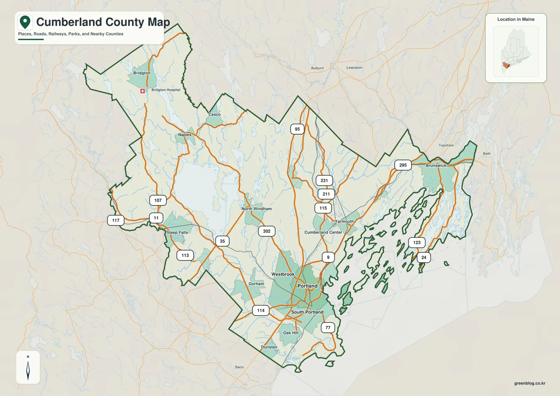
Roads connect the Portland coast with Sebago Lake and the northwestern interior
On the full county map, Portland is the easiest southern reference point. South Portland sits immediately below it, Westbrook lies just to the west, and Gorham appears farther inland. I-295 runs through the Portland area and continues northeast toward Yarmouth and Brunswick, while I-95 follows a more inland path through the county. Together, those routes make the southeastern half of Cumberland County look much more connected and road-dense than the lake country farther west.
U.S. 302 provides the clearest route for following the county away from the coast. From the Portland–Westbrook area it heads northwest through North Windham, passes near the southern and eastern side of Sebago Lake, and continues toward Naples. The road works well as a visual guide because it links the densely settled Portland side of the map with the broad inland lake district. Route 35 and other state roads add north-south connections around Gorham, Windham, and the communities near Sebago Lake.
The northwestern part of the county has a very different rhythm. Bridgton is a prominent place name near the upper-left portion of the map, with Naples to the southeast and smaller roads spreading toward Steep Falls and the county line. Routes 11, 107, 117, and 113 appear across this inland section. The network is less concentrated than it is around Portland, and lakes occupy much more of the visible landscape, so the map makes the transition from metropolitan coast to Maine lake country easy to see.
The eastern side changes again. Yarmouth and Brunswick anchor the northeastern road corridor, and I-295 carries the main visual line toward that part of the county. Near the coast, Routes 123 and 24 run into areas with long peninsulas and offshore islands. The county boundary becomes especially intricate here because it follows a shoreline broken by Casco Bay, inlets, and island communities rather than a simple inland line. That coastal outline is one of the features that makes Cumberland County immediately recognizable on a statewide map.
Neighboring county names also help with orientation. York County lies toward the southwest, Oxford County is to the northwest, Androscoggin County is to the northeast, and Sagadahoc County is east of the Brunswick side. The locator inset confirms that Cumberland County occupies a southern Maine position along the Atlantic. The map is designed for general geographic reference, however, not for determining legal property boundaries, surveying a parcel, or following live traffic and road-closure conditions.
All three official cities cluster around Portland
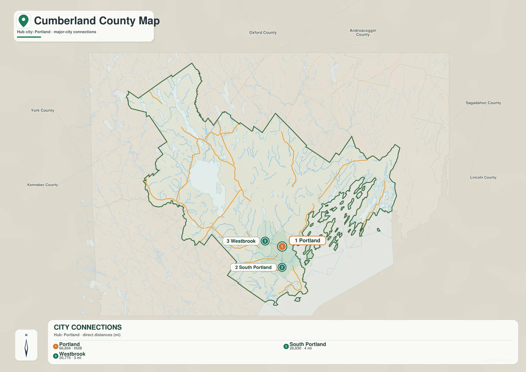
The city-connections map strips away most of the county detail and focuses on Portland, South Portland, and Westbrook. That choice is particularly useful in Cumberland County because these are the county’s three official cities according to the county government. Portland is shown as the hub, South Portland is immediately to the south across the harbor area, and Westbrook is inland to the west. The rest of the county remains visible only as geographic context, emphasizing how small the urban cluster is compared with the full county.
The connector labels show South Portland at about 4 miles from Portland and Westbrook at about 3 miles. Those are straight-line distances, not driving distances measured along streets or bridges. A road trip can be longer because vehicles must follow the actual street network and available crossings. The map is best used to compare proximity: both neighboring cities are only a few miles from the Portland hub even though they are separate municipalities.
This close grouping helps explain why the southern part of the general map contains so many overlapping roads and urban labels. Portland and South Portland face each other around the harbor, while Westbrook sits along the Presumpscot River corridor just inland. Interstate and local connections pass through the same compact area. By removing most route shields, the city map makes that concentration clearer than the full county map does.
The map’s city index also displays values of 68,854 for Portland, 26,930 for South Portland, and 20,775 for Westbrook. These should be treated as values embedded in the supplied map rather than assumed to be current population estimates, because the reference year is not stated in the package. For current demographic figures, an official source such as the U.S. Census Bureau is more appropriate. The geographic point of the map remains valid without relying on the age of those figures: the three cities sit very close together in the county’s southern coastal zone.
For a presentation about Greater Portland, this is usually the most direct image of the set. It avoids the visual complexity of Sebago Lake, Bridgton, Brunswick, and dozens of smaller roads while preserving the three-city relationship. It is not a complete settlement map, though. Towns such as Gorham, Windham, Yarmouth, Brunswick, and Bridgton are important to the county but intentionally fall outside the city ranking shown here.
Sebago Lake drains toward the coast through the Presumpscot River
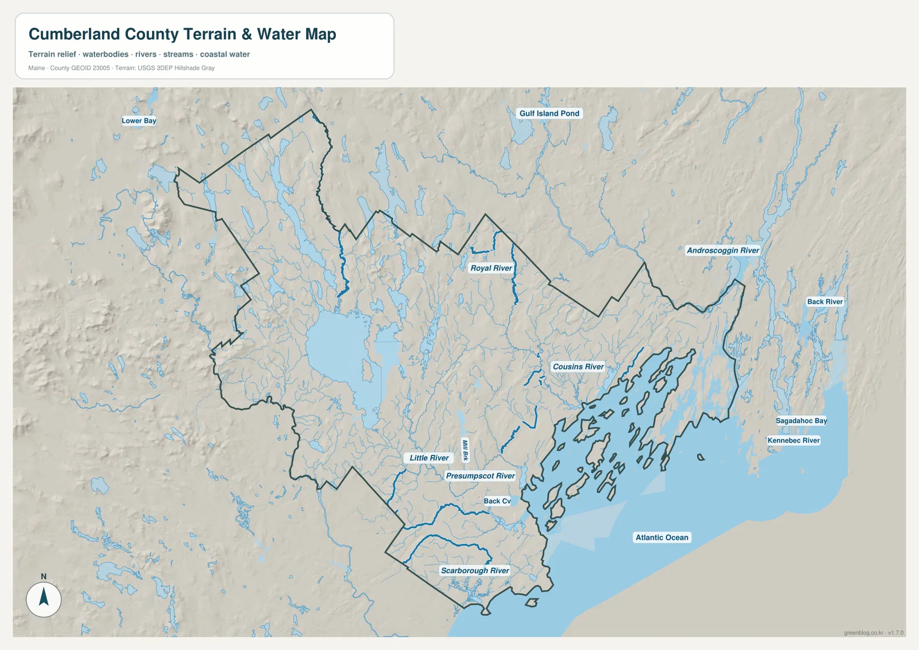
The terrain-and-water map changes the emphasis completely. Sebago Lake dominates the western-central part of the county and serves as the largest visual landmark away from the coast. Smaller lakes and streams surround it, especially toward the northwest. When this image is compared with the road map, the lake district around Naples, Windham, and the western interior becomes easier to understand because the water features explain why roads bend around broad areas that looked relatively open on the general map.
The Presumpscot River provides the clearest connection between the lake country and the Portland side of the county. It flows southeast from the Sebago Lake area through the interior and continues toward the coast, with Westbrook sitting along the river corridor. That relationship is useful because it ties together two parts of the map that can otherwise feel separate: the inland lake region and the metropolitan coast. On the terrain map, the river becomes a continuous geographic reference rather than just another blue line crossing a road network.
Other named waterways divide the eastern and southern parts of the county into smaller systems. The Royal River runs toward the Yarmouth area, the Cousins River appears closer to the coast, and Portland’s Back Cove is labeled beside the urban shoreline. Farther south, the Scarborough River reaches the Atlantic through low coastal terrain. The Little River is also shown inland from the southern coast. Together, these features show that Cumberland County is shaped by many short coastal rivers as well as the much larger Sebago–Presumpscot system.
Casco Bay adds another layer to the map. The county’s eastern coastline is broken into long fingers of land and numerous islands, creating a much more complicated boundary than the inland sides of the county. The Atlantic Ocean occupies the lower-right part of the image, while features outside the county such as the Kennebec River and Sagadahoc Bay appear farther east as regional reference points. These labels help place the Casco Bay shoreline within the broader midcoast geography of Maine.
Shaded relief suggests broad differences in terrain without giving survey-grade elevation. The western and northwestern interior appears more rolling and irregular, while the Portland–South Portland coastal zone is generally gentler at this scale. Around Sebago Lake and toward Bridgton, the landforms and lake basins create more visible relief. The shading is useful for recognizing those broad contrasts, but it should not be used to calculate an exact elevation, slope, or construction grade at a specific site.
The water layer has similar limits. It is a reference map of rivers, streams, lakes, coastal water, and terrain, not a flood map or navigation chart. It does not provide real-time river stages, tidal conditions, channel depth, water quality, or flood probability. Property, boating, emergency, or engineering decisions should be based on current information from USGS, FEMA, Maine agencies, or the responsible local authority.
Choosing the right map for Portland, the lake district, or the coast
Use the full county map when you need orientation across Cumberland County rather than detail about one theme. Starting at Portland, follow U.S. 302 northwest through Westbrook and North Windham toward Sebago Lake and Naples, then look farther north to Bridgton. A second glance along I-295 leads northeast through Yarmouth toward Brunswick. That simple sequence covers the county’s major contrast between the metropolitan south, inland lake country, and the northeastern coastal corridor.
Use the city-connections map when the question is specifically about the Greater Portland cluster. It gives a clean comparison among the county’s three cities and makes their proximity obvious without the distraction of the county’s many towns, lakes, and route numbers. The straight-line distance labels are especially useful for a geographic comparison, as long as they are not mistaken for driving mileage or estimated travel time.
Choose the terrain-and-water map when rivers, lakes, coastline, or broad landform differences matter most. It shows why Sebago Lake is such a dominant inland feature, how the Presumpscot River links that lake region with the Portland side, and how Casco Bay breaks the eastern boundary into peninsulas and islands. It also places shorter coastal rivers such as the Royal, Cousins, and Scarborough in the same county-wide view.
The WebP images in the article are optimized for convenient on-screen viewing. The ZIP archive contains the same three maps as original high-resolution JPG files, each measuring 3638 × 2572 pixels in landscape orientation. For a printed handout, the road map can provide the opening overview, followed by the city and water maps on separate pages. For a personal reference project, using only the map that matches the topic usually keeps the result clearer.
All three maps are general-reference products. They are not substitutes for parcel records, legal boundary descriptions, surveys, live road information, flood studies, nautical charts, or engineering data. Cumberland County combines urban streets, lake-country roads, islands, rivers, and a long Atlantic shoreline, so checking the appropriate current government source is important whenever a decision depends on precise or time-sensitive information.
Frequently Asked Questions
Why does Cumberland County look so different around Portland and Sebago Lake?
Portland sits in the county’s densely connected southern coastal area, while Sebago Lake lies northwest in a broader inland landscape of lakes, smaller communities, and more widely spaced roads. U.S. 302 provides a useful route for comparing the two areas because it runs from the Portland–Westbrook side through North Windham toward the Sebago Lake and Naples region.
Which map is best for comparing Portland, South Portland, and Westbrook?
The city-connections map is the clearest choice. It uses Portland as the hub and shows South Portland at about 4 miles and Westbrook at about 3 miles. Those values are straight-line distances rather than road mileage, so they are useful for comparing proximity but not for estimating a driving route or travel time.
Can the terrain-and-water map be used for Casco Bay navigation or flood decisions?
No. The map is intended to show the locations of major lakes, rivers, streams, coastal water, and broad relief. It does not contain navigation depths, tidal data, live river stages, flood probabilities, or legal property information. Use current USGS, FEMA, Maine, local, or nautical sources when those details are required.
Map File Information
Download the three high-resolution JPG maps described on this page together in one ZIP file.
- Included Files: county and major-road map, city-connections map, terrain and water map
- Printable Size: 3638 × 2572 pixels each
- File Type: JPG
Related Maps
Sources and References
- Cumberland County Government – About Cumberland County
- Cumberland County Government – Towns & Cities
- U.S. Census Bureau – TIGER/Line Shapefiles
- USGS – National Hydrography
- Maine DACF – Public Boat Launches and Water Sites
Green Map creates custom-edited map images using open geographic data sources such as geoBoundaries, Natural Earth, OpenStreetMap, and government open data. These maps are edited visual materials, not raw data files, and are provided for education, documents, presentations, and graphic reference.