West Baton Rouge Parish in south-central Louisiana is a narrow parish shaped by the Mississippi River along its eastern side. Port Allen, Brusly, and Addis form a north-south settlement corridor close to the river and LA 1, while Erwinville sits farther west amid agricultural land and a dense drainage network. U.S. 190 and I-10 provide the strongest east-west road references, but the large river bends are just as important for understanding the parish boundary. Matching high-resolution JPG originals for the three maps on this page can also be downloaded together in a ZIP for printing, classroom use, presentations, or detailed reference. High-resolution map files are available for download in the section below.
Port Allen is the parish seat. Louisiana’s official West Baton Rouge Parish profile lists Port Allen as the city and Addis and Brusly as towns. The parish government’s bicentennial history also identifies Port Allen as the governmental seat and describes the long relationship between the Mississippi River lowlands, agriculture, industry, and commerce. On the supplied map, starting with Port Allen and then placing Brusly and Addis to the south and Erwinville to the west gives the parish a simple framework despite its irregular river boundary.
Table of Contents
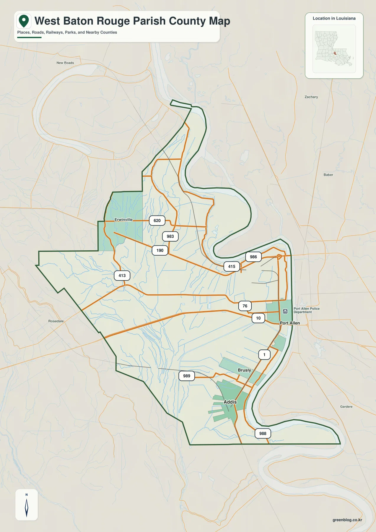
Port Allen anchors the northeastern parish beside the Mississippi River and U.S. 190
The general map places Port Allen directly beside the Mississippi River, with U.S. 190 and LA 1 providing the clearest road references. LA 415 connects the northern and western side, and LA 986 appears near the river north of the city. Because Baton Rouge lies immediately across the river, Port Allen functions not only as the parish seat but also as a gateway into the larger Baton Rouge urban area.
South of Port Allen, I-10 crosses the river and LA 76 extends west into the parish. Using U.S. 190 in the north and I-10 farther south as two major east-west markers makes the road pattern much easier to follow. Roads close to the Mississippi often change direction with the river bends, creating a different geometry from the straighter agricultural roads farther west.
Brusly and Addis continue the LA 1 settlement corridor south of Port Allen
Brusly lies south of Port Allen, with Addis farther south, and both towns sit close to LA 1. LA 989 serves the Brusly side, while LA 988 provides another reference below Addis near the southern boundary. Placing the communities in Port Allen–Brusly–Addis order makes the parish’s populated eastern edge easy to remember because the sequence runs nearly parallel to the Mississippi River.
Below Addis, the parish boundary curves sharply with a broad Mississippi River bend. The shape of the river becomes more useful than road direction for understanding this lower section. Developed areas also thin quickly south of Addis, leaving more agricultural land, drainage channels, and open space than in the Port Allen area.
Erwinville and LA 413 organize the western agricultural interior
Erwinville is the most visible named community on the western side and lies north of U.S. 190. LA 413 connects the western boundary with the interior, while LA 620 and LA 983 help define roads east and north of Erwinville. Compared with Port Allen or Brusly, the landscape is much less urban and contains many narrow waterways between agricultural roads.
The western parish boundary bends toward Pointe Coupee Parish and West Feliciana Parish rather than following one clean line. U.S. 190 provides the easiest continuous road reference from that side back toward Port Allen. Using Erwinville as the western anchor and Port Allen as the eastern anchor makes the broad rural middle section much easier to understand.
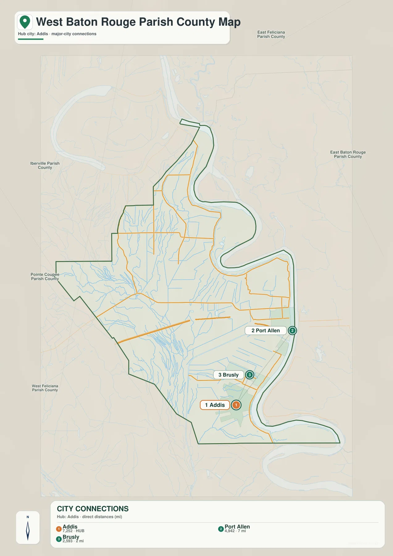
The city-connections map gives straight-line distances from Addis
The city-connections graphic uses Addis as its hub and draws direct links to Brusly and Port Allen. The legend shows about 2 miles from Addis to Brusly and about 7 miles from Addis to Port Allen. These are straight-line distances between the mapped points, not driving mileage, so actual road distance and travel time depend on the selected route and exact starting point.
The direction is just as useful as the mileage. Addis is the southern town, Brusly lies immediately to the north, and Port Allen is farther north beside the Mississippi River. By removing most local roads, the city-connections view makes the spacing of the river-side communities easy to compare, while the general map remains the better choice for route planning.
Mississippi River bends define the eastern boundary and the river-side towns
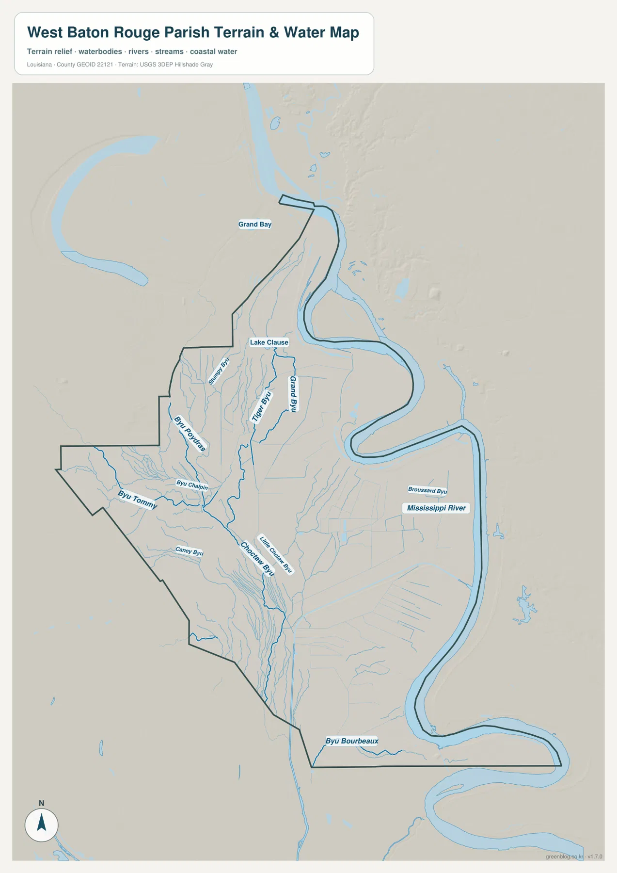
The terrain-and-water map is dominated by the Mississippi River. The river forms several broad bends along the eastern side, shaping the parish boundary around Port Allen, Brusly, Addis, and the long southern extension. In many places, the river curve is a more important orientation clue than any road because the administrative line follows the water so closely.
Broussard Bayou appears near the river-side interior, while Bayou Bourbeaux runs near the lower boundary. Grand Bay and Lake Clause are labeled farther north. Together, these features show that West Baton Rouge Parish is not simply a strip beside one large river; smaller former channels, bays, bayous, and wet lowlands also occupy the floodplain landscape.
Choctaw Bayou and smaller bayous form a dense western drainage network
Choctaw Bayou is one of the strongest named interior waterways across the central and western parish. Little Choctaw Bayou runs nearby, while Tiger Bayou and Grand Bayou appear farther north. Bayou Poydras and Bayou Chalpin help organize the western side. Although these channels are much smaller than the Mississippi River, they divide the agricultural interior into a surprisingly dense drainage network.
Bayou Tommy and Caney Bayou appear farther southwest, with numerous smaller drainage lines around them. The broad agricultural spaces on the road map therefore look much more complex on the water map. This terrain-and-water view is intended for general geographic reference only; it does not provide flood-zone classifications, water depth, navigability, levee or drainage-system condition, or legal property boundaries.
Separating the river-side towns from the western bayou country simplifies the parish
A practical first pass begins with Port Allen, Brusly, and Addis along the eastern river corridor. Use U.S. 190 and I-10 as east-west references and LA 1 as the north-south road connecting the populated side. Then add Erwinville and LA 413 to the west. The parish is narrow and elongated, but the large Mississippi bends make the eastern edge far more irregular than its overall shape first suggests.
For water features, separate the Mississippi River in the east from the Choctaw Bayou, Bayou Poydras, and Caney Bayou systems in the west. The general map is best for communities and roads, the city-connections map for relative spacing, and the terrain-and-water map for river bends and drainage channels. The contrast between the populated river corridor and the agricultural bayou interior is the main geographic pattern tying the three map views together.
High-resolution JPG files preserve river bends and smaller water labels
The downloadable ZIP contains the original JPG files corresponding to the three previews on this page: the general parish map, the city-connections map, and the terrain-and-water map. Each original image is 2572 by 3638 pixels, providing more room to inspect route numbers, community names, bayou labels, and the Mississippi River bends than the web preview. The larger format is especially useful across the western drainage network and the long southern boundary.
Choose the general map when Port Allen, Brusly, Addis, and the main roads need to appear together. Use the city-connections view when direction and straight-line spacing from Addis are the main question. The water map is the better choice for the Mississippi River, Choctaw Bayou, Caney Bayou, and the smaller floodplain waterways. These are general reference maps rather than legal boundary, survey, flood-risk, or real-time navigation products.
Frequently Asked Questions
What is the parish seat of West Baton Rouge Parish?
Port Allen is the parish seat. Louisiana’s official parish profile identifies Port Allen as the seat, and the supplied map places it beside the Mississippi River near U.S. 190 and LA 1. Brusly and Addis continue south along the same river-side settlement corridor.
Are the 2- and 7-mile labels driving distances?
No. They are straight-line distances from Addis: about 2 miles to Brusly and about 7 miles to Port Allen. Actual driving mileage depends on the selected roads and exact starting point, so current navigation information is better for trip planning.
Can the Mississippi River and bayou map be used for flood or boating decisions?
No. It is a general geographic reference showing the Mississippi River, Choctaw Bayou, Little Choctaw Bayou, Caney Bayou, and nearby waterways. It does not provide flood-zone classifications, water depth, navigation clearance, levee or drainage-system condition, or legal property boundaries.
Map File Information
The ZIP contains the original high-resolution JPG files corresponding to the general parish map, city-connections map, and terrain-and-water map shown on this page.
- Included Files: parish map JPG, city-connections map JPG, terrain-and-water map JPG
Related Maps
Sources and references
For parish-seat and municipality information, see the Louisiana.gov West Baton Rouge Parish Profile. Local government and historical context are available from West Baton Rouge Parish Government and its Bicentennial history. Road and place context is available from the Louisiana DOTD West Baton Rouge Parish Official Map. General boundary data are documented by the U.S. Census Bureau TIGER/Line Shapefiles, and water-feature data are documented through USGS National Hydrography.
Green Map creates custom-edited map images using open geographic data sources such as geoBoundaries, Natural Earth, OpenStreetMap, and government open data. These maps are edited visual materials, not raw data files, and are provided for education, documents, presentations, and graphic reference.