Terrebonne Parish in southern Louisiana changes dramatically from north to south. Houma, Gray, Schriever, and Bourg occupy the more road-focused northern section, while Montegut, Chauvin, and Dulac lead into a vast landscape of bayous, canals, marshes, and open coastal bays. U.S. 90, LA 311, and LA 182 are useful in the north, but water features become more important than roads across much of the lower parish. This page explains those visible settlement, road, and water relationships, and the matching high-resolution JPG map files can be downloaded together in a ZIP.
Houma is the parish seat and the only place ranked as a major city on the supplied city-index map. Louisiana’s official Terrebonne Parish profile identifies Houma as the parish seat and lists Gray, Schriever, Chauvin, Dulac, and Montegut among the parish’s communities. On the general map, Houma is also the most developed road center. Starting there and then moving north to Gray and Schriever or south toward Bourg, Montegut, Chauvin, and Dulac makes the transition from urbanized land to coastal wetlands easy to see.
Table of Contents
Houma anchors the road network around LA 311 and LA 182
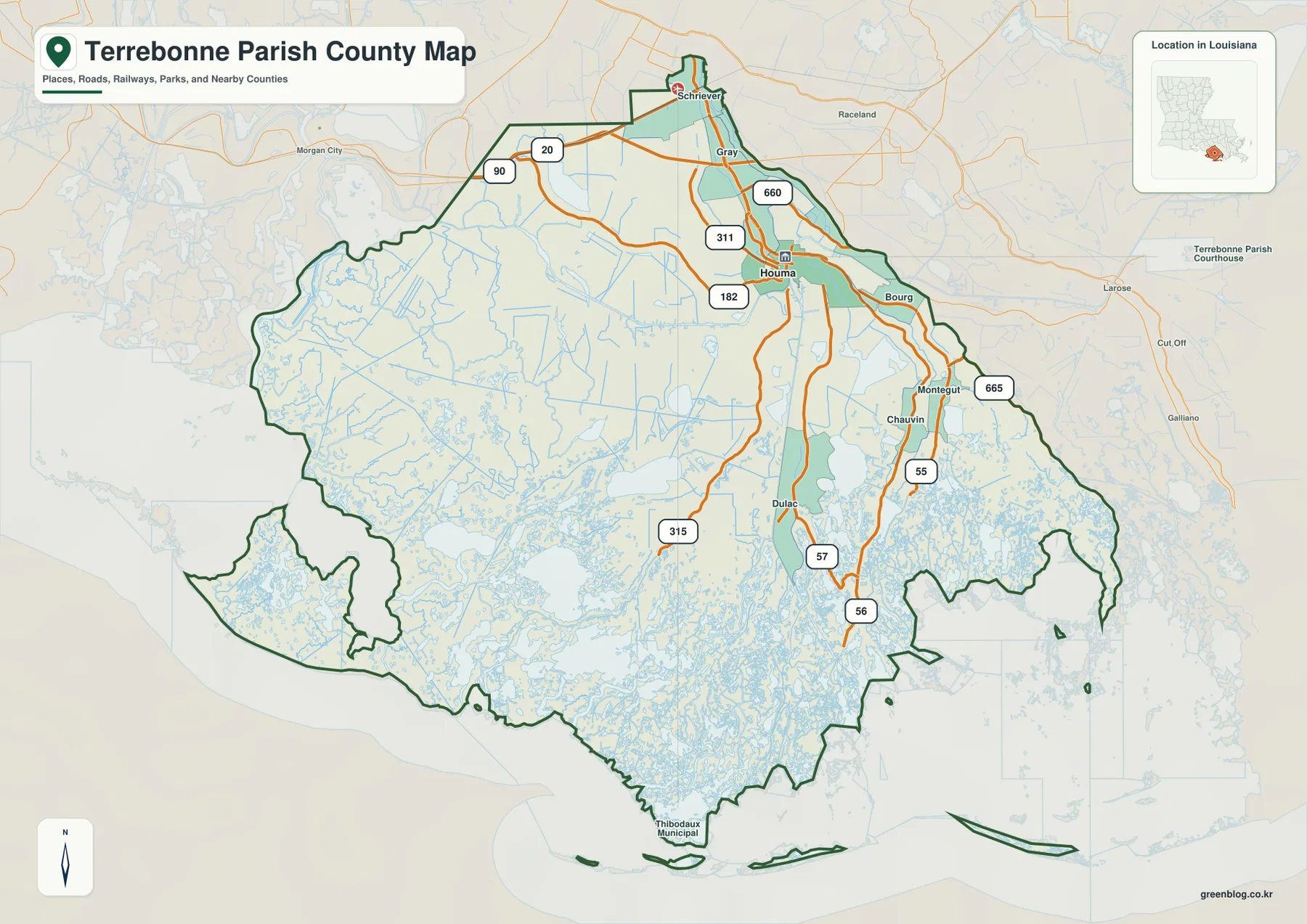
The general map places Houma in the northeastern part of the parish’s developed land, where LA 311, LA 182, and several local routes converge. Gray lies directly to the north, and Schriever sits farther up near U.S. 90 and LA 20. This northern section contains the clearest road grid in the parish and is the easiest place to begin before following the map into the marshier south.
LA 660 appears near the Gray–Houma area, while LA 182 provides another east-west reference through the developed corridor. U.S. 90 crosses the extreme northern side toward Morgan City and Raceland. Once those roads are established, smaller routes and water channels farther south become easier to interpret because the reader still has a clear reference back to Houma.
Bourg, Montegut, and Chauvin form a long southeastern settlement corridor
Southeast of Houma, Bourg appears first, followed by Montegut and Chauvin farther south. LA 55 is one of the clearest road references through this corridor, while LA 665 helps orient the Bourg side near the eastern boundary. Development is no longer concentrated in one wide urban block; communities and roads become narrower and more closely tied to waterways.
Around Montegut and Chauvin, the road network bends with the marsh and channel pattern rather than following a simple grid. The parish boundary is also highly irregular along the eastern and southern sides. Looking at LA 55 together with the nearby bayou corridors provides a much clearer sense of direction than relying on compass points alone.
Dulac and LA 57–LA 315 lead into the southwestern marsh
Dulac lies south of Houma in a narrow settled corridor reached by LA 57. Farther west, LA 315 extends deep into the marsh, while LA 56 provides another long route through the southeastern interior. These roads become isolated lines surrounded by water features, very different from the more connected network around Houma.
Large urban labels disappear quickly south of Dulac and Chauvin. From that point, canals, bayous, shallow water, and open marsh occupy most of the map. This sharp transition is one of the defining visual characteristics of Terrebonne Parish: the northern communities are road-oriented, but the lower parish is fundamentally a coastal wetland landscape.
The city index ranks only Houma as the selected major city
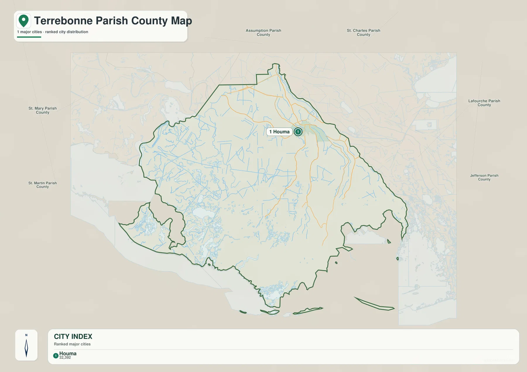
The city-index graphic contains a single ranked place: Houma is number 1. That number is a city ranking, not a distance measurement. Gray, Schriever, Bourg, Montegut, Chauvin, Dulac, and other communities remain visible on the general parish map but are not included in this major-city index.
The city map should therefore not be treated as a complete list of Terrebonne Parish communities. Its purpose is to emphasize Houma as the parish’s clearest urban center without the distraction of the full road and water network. For settlement distribution, coastal communities, and actual route connections, the general map provides much more context.
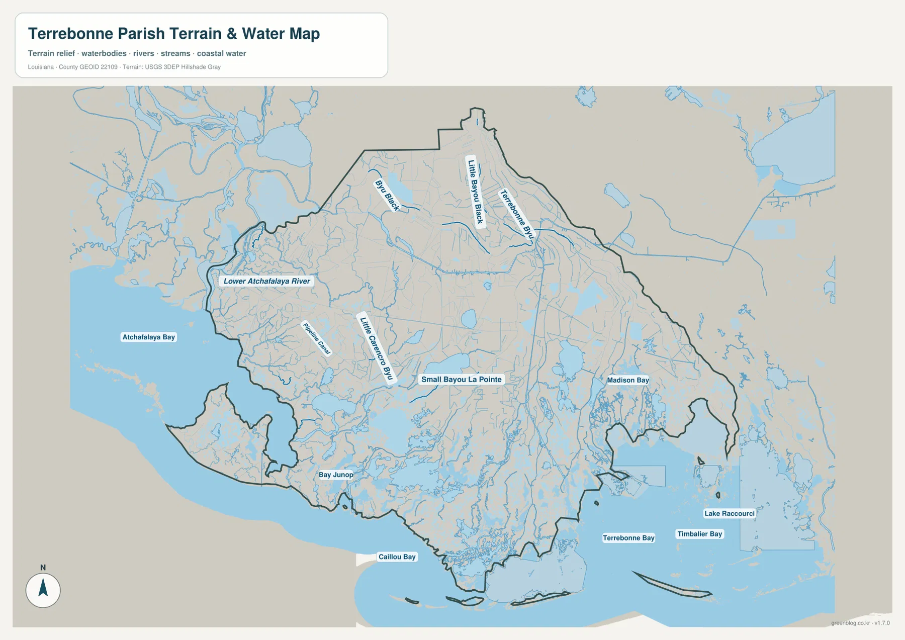
Lower Atchafalaya River and the Bayou Black system define the western interior
The terrain-and-water map brings the western side into focus. Lower Atchafalaya River follows the parish’s western edge, while Bayou Black and Little Bayou Black appear farther inside. The area that looks lightly developed on the road map becomes densely patterned with water once the smaller channels are emphasized.
Pipeline Canal and Little Carencro Bayou add more named waterways across the west-central section, and Small Bayou La Pointe provides another reference farther south. The mix of natural bayous, engineered canals, and marsh water makes this region difficult to describe with roads alone. In many places, the named channel is a more useful geographic anchor than the nearest settlement.
Terrebonne Bay, Timbalier Bay, and Caillou Bay dominate the Gulf-facing coast
The southern water map opens into large coastal bays. Terrebonne Bay and Timbalier Bay occupy much of the lower-right side, while Caillou Bay lies farther west. Lake Raccourci appears near the southeastern coastal area, and Madison Bay and Bay Junop provide additional references between the interior marsh and the open bays.
The coastline is not a single clean line. Small islands, marsh fragments, canals, and shallow-water areas break the southern boundary into a complex pattern. This map is intended for general geographic reference only. It does not provide flood-zone status, tidal depth, boating clearance, levee or floodgate condition, or legal property boundaries, so those decisions require current specialized information.
Reading from Houma southward shows the shift from roads to wetlands
A practical first pass begins with Houma, Gray, and Schriever in the north. U.S. 90, LA 311, and LA 182 establish the main developed corridor; Bourg, Montegut, Chauvin, and Dulac then extend the map south and southeast. LA 55, LA 57, and LA 315 are especially useful once the road network starts to narrow into the wetland landscape.
For water features, separate Lower Atchafalaya River and Bayou Black in the west from Small Bayou La Pointe in the interior and the large Terrebonne–Timbalier bay system along the coast. The general map is best for communities and roads, the city index for Houma’s urban role, and the terrain-and-water map for marshes, canals, and coastal bays. Enlarging the original JPG makes the smaller bayou and canal labels easier to distinguish.
High-resolution JPG files preserve fine marsh and channel detail
The downloadable ZIP contains the original JPG files corresponding to the three previews on this page: the general parish map, the ranked city map, and the terrain-and-water map. Each original image is 3638 by 2572 pixels, providing more room to inspect route numbers, community names, bayou labels, and coastal-water names than the web preview. The larger format is especially useful south of Chauvin and Dulac where small channels become densely packed.
Choose the general map when Houma, the northern road network, and the southern communities need to appear together. Use the city index when Houma’s position as the selected major city is the main subject. The water map is the better choice for Lower Atchafalaya River, Bayou Black, Terrebonne Bay, Timbalier Bay, and the coastal marsh system. These are general reference maps rather than legal boundary, survey, flood-risk, or real-time navigation products.
Frequently Asked Questions
What is the parish seat of Terrebonne Parish?
Houma is the parish seat. Louisiana’s official parish profile identifies Houma as the seat, and the supplied map also makes it the clearest urban and road center. Gray and Schriever lie to the north, while Bourg, Montegut, Chauvin, and Dulac extend toward the wetter southern part of the parish.
Why does the city index show only Houma?
The city index ranks selected major cities and shows Houma as number 1. The number is not a distance measurement, and the map does not mean that Houma is the only community in the parish. Other places such as Gray, Schriever, Bourg, Montegut, Chauvin, and Dulac are visible on the general map.
Can the Terrebonne Bay and marsh map be used for flood or boating decisions?
No. It is a general geographic reference showing Lower Atchafalaya River, bayous, canals, Terrebonne Bay, Timbalier Bay, and nearby coastal waters. It does not provide flood-zone classifications, tidal depth, navigation clearance, levee condition, or legal property boundaries. Those decisions require current specialized information.
Map File Information
The ZIP contains the original high-resolution JPG files corresponding to the general parish map, ranked city map, and terrain-and-water map shown on this page.
- Included Files: parish map JPG, ranked city map JPG, terrain-and-water map JPG
Related Maps
Sources and references
For parish-seat and community information, see the Louisiana.gov Terrebonne Parish Profile and Terrebonne Parish Consolidated Government. Road and place context is available from the Louisiana DOTD Terrebonne Parish Official Map. General boundary data are documented by the U.S. Census Bureau TIGER/Line Shapefiles, and national water-feature data are documented through USGS National Hydrography.
Green Map creates custom-edited map images using open geographic data sources such as geoBoundaries, Natural Earth, OpenStreetMap, and government open data. These maps are edited visual materials, not raw data files, and are provided for education, documents, presentations, and graphic reference.