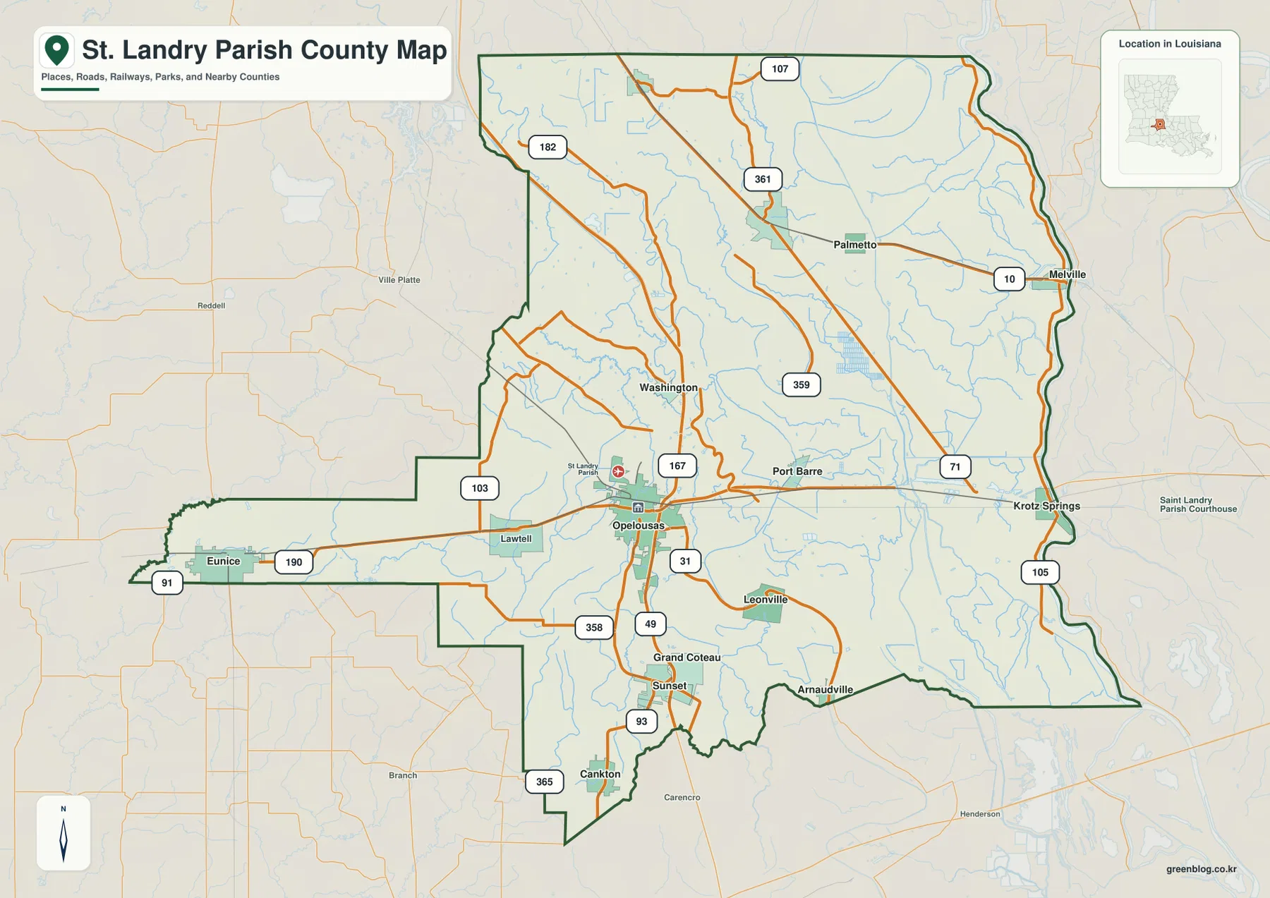
St. Landry Parish in south-central Louisiana is easiest to organize around Opelousas and the long U.S. 190 corridor. The highway links Eunice and Lawtell on the west with Opelousas in the center and Port Barre and Krotz Springs toward the east. South of Opelousas, Sunset, Grand Coteau, Leonville, and Arnaudville form a tighter cluster, while Washington, Palmetto, and the eastern lowlands spread across a much broader rural area. This page explains those road, settlement, and water relationships, and the matching high-resolution JPG map files can be downloaded together in a ZIP.
Opelousas is the parish seat. Louisiana’s official St. Landry Parish profile lists Opelousas and Eunice as cities, with Arnaudville, Grand Coteau, Krotz Springs, Leonville, Melville, Port Barre, Sunset, and Washington among the towns and Cankton and Palmetto among the villages. On the supplied map, Opelousas is also the clearest road hub because U.S. 190 and U.S. 167 meet there. That intersection gives the parish a natural center before the map spreads west to Eunice and east toward the lower Atchafalaya country.
Table of Contents
U.S. 190 connects Eunice, Opelousas, Port Barre, and the eastern edge
The general map makes U.S. 190 the strongest east-west road reference. It enters the long western extension through Eunice, passes Lawtell, reaches Opelousas, and continues through Port Barre toward Krotz Springs. Following that one route gives a quick sense of the parish’s unusual width and shows why Opelousas functions as the central junction rather than simply the largest label on the page.
U.S. 167 adds the main north-south reference through the Opelousas area. It reaches toward Washington to the north and toward Grand Coteau and Sunset to the south. LA 31, LA 49, and LA 93 are clustered around the southern central section, while LA 103 and LA 358 help with the western and southwestern sides. East of Opelousas, LA 359 and U.S. 71 provide additional references around Port Barre and the eastern interior.
Sunset, Grand Coteau, Leonville, and Arnaudville create a tighter southern cluster
The southern central parish looks noticeably more settled than much of the north. Grand Coteau and Sunset sit just below Opelousas along the U.S. 167 and LA 93 corridor, while Leonville lies farther east and Arnaudville reaches the southeastern edge. Because these towns are relatively close together, the map shifts from the long-distance U.S. 190 pattern to a compact network of state roads and small communities.
Cankton appears near the southwestern boundary, and Lawtell occupies the U.S. 190 corridor between Eunice and Opelousas. Neither is part of the six-place city index, but both are useful landmarks on the detailed map. Lawtell helps divide the long western road section, while Cankton gives the lower boundary a recognizable place reference beyond Sunset.
Washington, Palmetto, Melville, and Krotz Springs reveal how far the parish extends beyond Opelousas
Washington lies north of Opelousas near the U.S. 167 corridor, while Palmetto is farther east in the broad northern interior. LA 182 and LA 107 are useful in the northwest, LA 361 crosses the upper central area, and LA 10 provides a clear reference around Melville. This part of the parish contains fewer large settlement blocks and many more small waterways than the southern cluster.
Melville and Krotz Springs occupy the far eastern side and make the parish’s full width easier to appreciate. Krotz Springs sits near the U.S. 190 crossing at the eastern boundary, while Melville lies farther north along LA 10. These places show that St. Landry Parish is not simply the Opelousas–Eunice corridor; it also includes a wide lowland section toward the Atchafalaya side.
The ranked city index spreads six selected communities across the parish
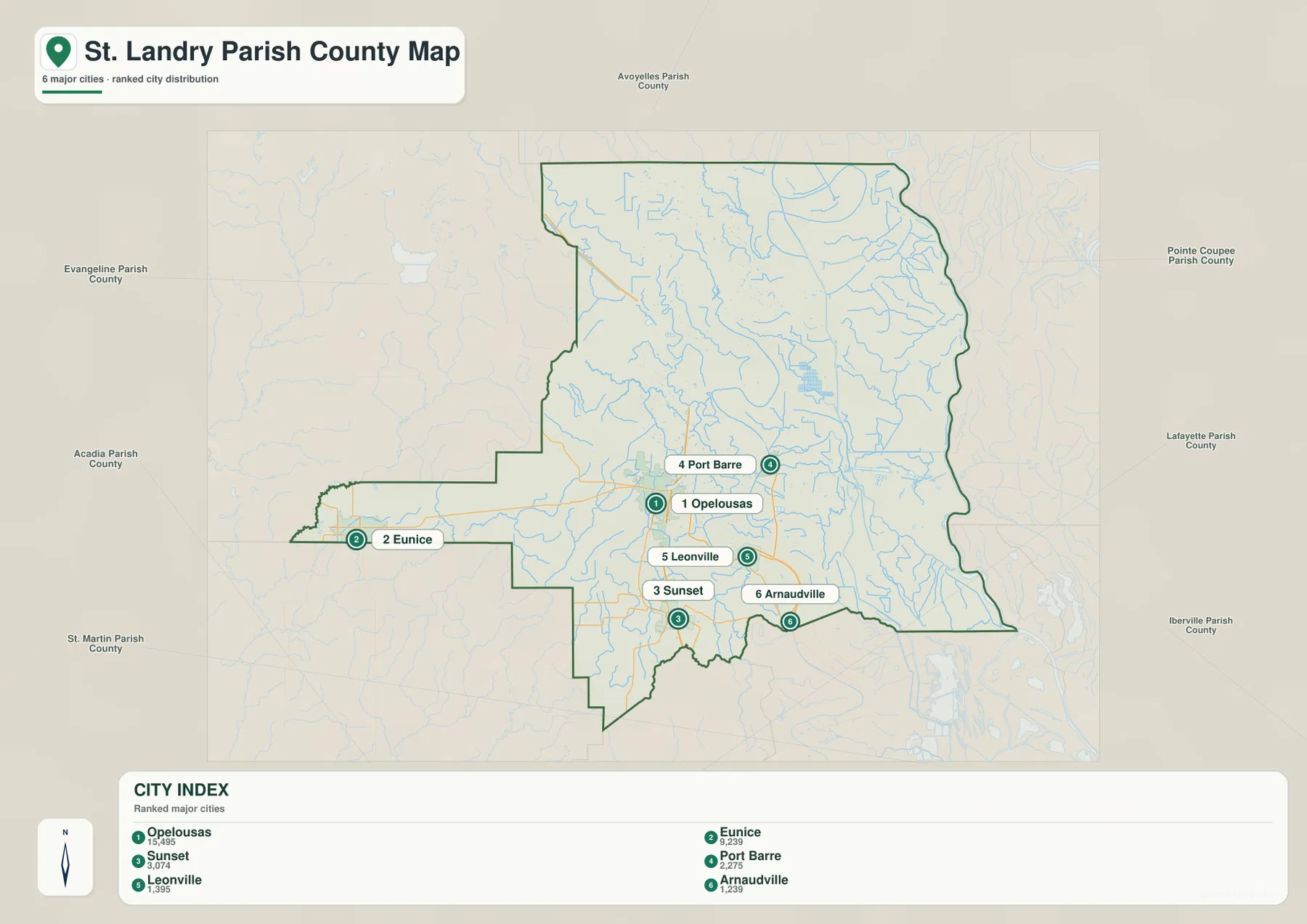
The city-index graphic ranks six selected places: Opelousas is number 1, Eunice 2, Sunset 3, Port Barre 4, Leonville 5, and Arnaudville 6. These are rankings, not straight-line or driving distances from Opelousas. The distribution itself is useful because Eunice sits far west, Port Barre lies east of the hub, Sunset is south, and Leonville and Arnaudville occupy the southeastern side.
Washington, Grand Coteau, Krotz Springs, and other places visible on the general map are not included in the six-place index. That means the city graphic should not be treated as a complete municipality list. It is best for comparing the selected communities without the distraction of dozens of road labels, while the general map remains the better reference for the full settlement network.
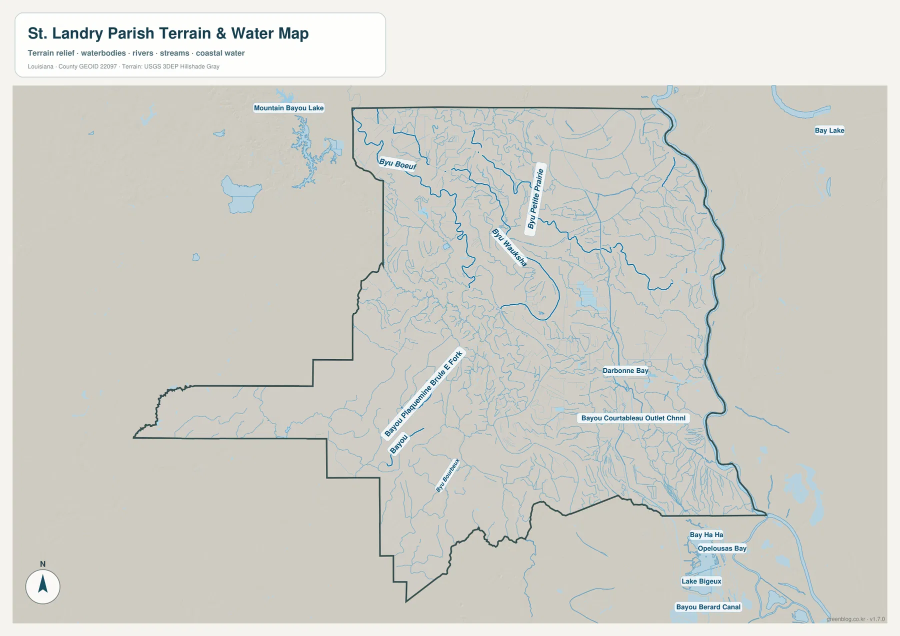
Bayou Boeuf and Bayou Petite Prairie organize the northern drainage
The terrain-and-water map gives the northern parish a very different appearance from the road view. Bayou Boeuf curves through the northwestern section, while Bayou Petite Prairie provides another long water reference farther east. Many thin tributaries branch between and around them, showing that the upper parish is divided by numerous small channels rather than one dominant lake.
Mountain Bayou Lake appears beyond the northwestern parish edge and provides wider regional context. Inside the boundary, the water network becomes increasingly intricate toward the central and eastern side, where unnamed tributaries join the larger bayous. These features help explain why a settlement-only map understates the amount of drainage structure present across the rural north.
Bayou Plaquemine Brulee Fork and Bayou Courtableau lead into the southern lowlands
In the southwest, Bayou Plaquemine Brulee Fork is one of the strongest named channels and is joined by several smaller bayous. Farther east, Darbonne Bay and the Bayou Courtableau Outlet Channel mark a different lowland water network. The concentration of channels increases toward the eastern boundary, where the terrain-and-water map becomes much denser than the general road view.
Beyond the southeastern edge, Bay Ha Ha, Opelousas Bay, Lake Bigeux, and Bayou Berard Canal add wider lowland context. They help show how the parish connects geographically with the broader Atchafalaya basin environment, even though those named features are not all inside the parish itself. The map is a general reference only and does not provide flood-zone classifications, water depth, navigability, drainage-operation status, or legal property boundaries.
Use Opelousas and U.S. 190 for roads, then split the bayou systems by section
A practical road-first approach begins at Opelousas and follows U.S. 190 west to Eunice and east to Port Barre and Krotz Springs. U.S. 167 then establishes the north-south direction through Washington, Opelousas, Grand Coteau, and Sunset. Leonville and Arnaudville complete the southeastern settlement pattern, while Melville provides a useful far-eastern reference in the north.
For water features, separate the northwestern Bayou Boeuf system from Bayou Petite Prairie, then move south to Bayou Plaquemine Brulee Fork and east toward Bayou Courtableau Outlet Channel. The general map is best for communities and roads, the city index for the six selected places, and the terrain-and-water map for bayous, bays, and drainage channels. Enlarging the original JPG is especially helpful when small tributary labels become difficult to read on screen.
Original JPG files preserve the smaller road and bayou labels
The downloadable ZIP contains the original JPG files corresponding to the three previews on this page: the general parish map, the ranked city map, and the terrain-and-water map. Each original image is 3638 by 2572 pixels, providing more room to inspect route numbers, community names, bayou labels, and small drainage features than the web preview. The files are useful for printing, classroom material, presentation slides, and personal geographic reference.
Choose the general map when Opelousas, U.S. 190, the parish boundary, and the wider town network need to appear together. Use the city index for a quick comparison of Opelousas, Eunice, Sunset, Port Barre, Leonville, and Arnaudville. The water map is the better choice for Bayou Boeuf, Bayou Petite Prairie, Bayou Plaquemine Brulee Fork, and the Courtableau lowlands. These are general reference maps rather than legal boundary, survey, flood-risk, or real-time navigation products.
Frequently Asked Questions
What is the parish seat of St. Landry Parish?
Opelousas is the parish seat. Louisiana’s official parish profile identifies it as the seat, and the supplied map also makes it the clearest transportation hub because U.S. 190 and U.S. 167 meet there. Eunice lies far to the west, Port Barre to the east, and Sunset to the south.
Do the numbers 1 through 6 on the city map show distance from Opelousas?
No. They are rankings for Opelousas, Eunice, Sunset, Port Barre, Leonville, and Arnaudville. The graphic does not show straight-line or driving mileage, so use the general road map and current navigation information when distance or travel time matters.
Can the Bayou Courtableau and bayou map be used for flood or navigation decisions?
No. It is a general geographic reference showing Bayou Boeuf, Bayou Petite Prairie, Bayou Plaquemine Brulee Fork, Bayou Courtableau Outlet Channel, and nearby water features. It does not provide flood-zone ratings, water depth, navigability, drainage-operation status, or legal property boundaries.
Map File Information
The ZIP contains the original high-resolution JPG files corresponding to the general parish map, ranked city map, and terrain-and-water map shown on this page.
- Included Files: parish map JPG, ranked city map JPG, terrain-and-water map JPG
Related Maps
Sources and references
For parish-seat and municipality information, see the Louisiana.gov St. Landry Parish Profile and the St. Landry Parish Government website. General boundary data are documented by the U.S. Census Bureau TIGER/Line Shapefiles, and national water-feature data are documented through USGS National Hydrography.
Green Map creates custom-edited map images using open geographic data sources such as geoBoundaries, Natural Earth, OpenStreetMap, and government open data. These maps are edited visual materials, not raw data files, and are provided for education, documents, presentations, and graphic reference.