Rapides Parish sits in central Louisiana and is easiest to recognize by the Alexandria–Pineville urban area on opposite sides of the Red River. I-49, U.S. 71, and U.S. 167 converge around this central corridor, while Ball and Boyce lie to the north and northwest and Woodworth, Glenmora, Forest Hill, and Cheneyville extend into the south. This page explains those visible settlement and road relationships before following the parish’s rivers, reservoirs, bayous, and creeks. The matching high-resolution JPG map files can be downloaded together in a ZIP.
Alexandria is the parish seat and the largest developed place on the supplied map. Louisiana’s official Rapides Parish profile lists Alexandria and Pineville as cities and identifies Ball, Boyce, Cheneyville, Glenmora, Lecompte, and Woodworth among the towns. Alexandria and Pineville form the obvious central pair, so locating them first makes it much easier to place the northern communities, the widely spread southern settlements, and the road network that connects them.
Table of Contents
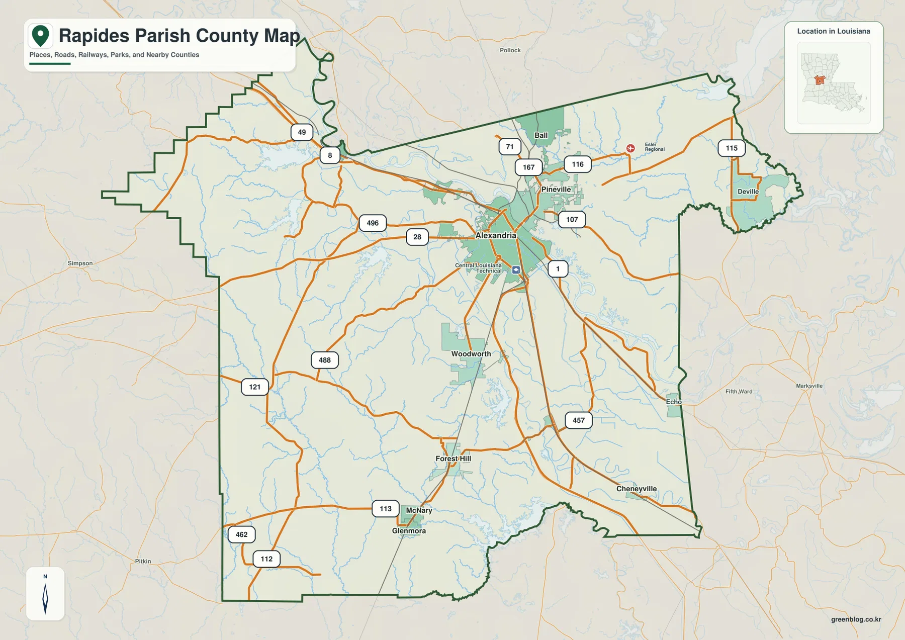
Alexandria and Pineville form the central urban pair across the Red River
The general map places Alexandria on the west side of the Red River and Pineville on the east and northeast side. Multiple road connections cross the river between them, so the two separate municipalities read visually as one broad central urban area. Ball lies just north of Pineville, while the Alexandria side contains the larger concentration of roads, institutions, and developed land.
I-49 is the clearest north-south highway reference, entering from the northwest and passing through the Alexandria area before continuing south. U.S. 71 and U.S. 167 are especially useful around Pineville and Ball, while LA 28 approaches Alexandria from the west. LA 107 and LA 115 serve the east, and LA 1 and LA 457 provide important references farther southeast. Together they show how the central city network fans outward into a much larger parish.
Ball and Boyce anchor the north while Woodworth and Glenmora extend the map southward
Ball is positioned north of Pineville near U.S. 167, making it the easiest northern community to connect directly to the central urban area. Boyce lies farther west, where LA 8 and nearby routes lead into the broad northwestern side of the parish. Deville occupies a very different position in the east near LA 115, showing that the northern half is not organized along one single corridor.
South of Alexandria, Woodworth is relatively close to the city, while Forest Hill, McNary, and Glenmora are farther southwest. Cheneyville sits toward the southeast and Echo appears near the eastern edge. Roads such as LA 113, LA 112, LA 121, LA 462, and LA 457 become more useful than the interstate when locating these outlying places. The wide spacing between them also makes the southern parish look much less urban than the Alexandria–Pineville core.
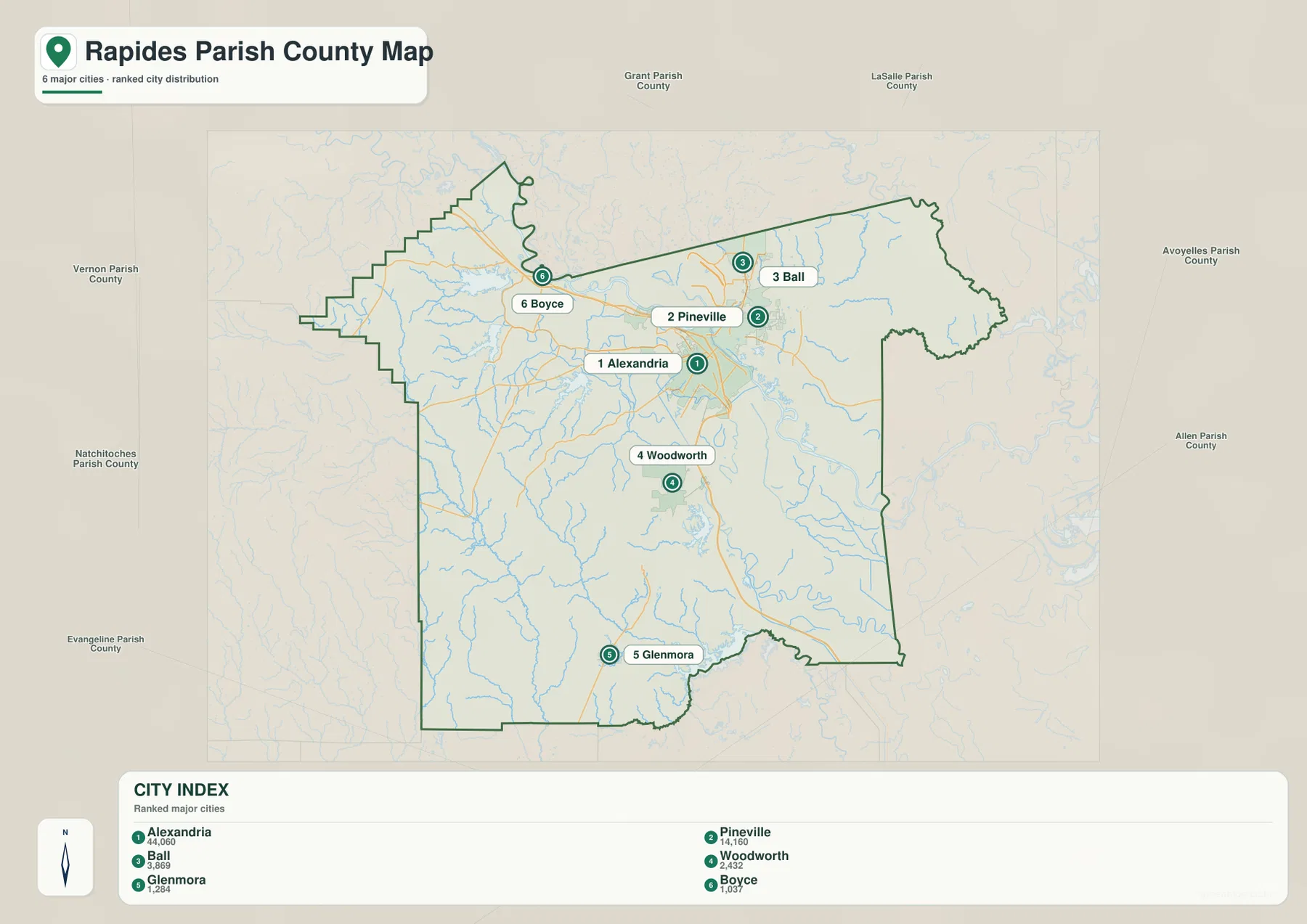
The ranked city index separates six major places from the wider settlement network
The city graphic is a ranked distribution map, not a distance diagram. Alexandria is number 1, Pineville 2, Ball 3, Woodworth 4, Glenmora 5, and Boyce 6. The first three are concentrated in the central and northern part of the parish, while Woodworth and Glenmora extend the selected group southward and Boyce sits to the northwest. The ranking makes the dominance of the Alexandria–Pineville area immediately clear.
The numbers do not represent mileage from Alexandria. Deville, Forest Hill, Cheneyville, Echo, and other labels visible on the general map are also not part of this six-place index. Use the city map when you need a simplified comparison of the selected communities, and return to the general parish map when smaller settlements, highways, and boundary details matter.
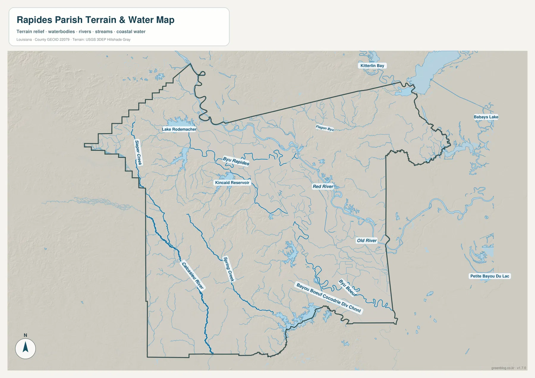
The Red River is the strongest water reference through the central and eastern parish
The terrain-and-water map makes the Red River the dominant central feature. It enters from the north, passes the Alexandria–Pineville area, and bends toward the southeast. On the road map the river can look like the line separating the two central cities; on the water-focused view it becomes a continuous main channel connected to a large network of smaller streams and lowland water features.
West of Alexandria, Bayou Rapides provides another long named water reference. Kincaid Reservoir is a prominent water body farther west, while Lake Rodemacher is labeled in the northwest. These features help distinguish the western half from the Red River corridor and show that the parish contains substantial inland water areas away from the main river itself.
The Calcasieu River and Bayou Boeuf system distinguish the southern corners
The southwest contains a different drainage pattern. The Calcasieu River runs southward through that side of the parish, with Spring Creek and many smaller tributaries around it. Slater Creek is labeled close to the western edge. These waterways are useful geographic references around the Forest Hill and Glenmora side of the parish, where major urban labels are much less common.
In the southeast, Bayou Boeuf and the Bayou Boeuf–Cocodrie Diversion Channel form long, conspicuous water features, while Old River appears near the eastern boundary. Kitterlin Bay is visible beyond the northeastern edge as a regional reference. The water map is intended for geographic orientation only; it does not provide flood-zone ratings, water depth, navigability, levee status, or legal property boundaries.
Separating the central city corridor from the outer parish makes the map easier to use
A practical first pass is to begin with Alexandria and Pineville, then add Ball and Boyce to the north and northwest and Woodworth, Glenmora, and Cheneyville to the south. For roads, I-49 and U.S. 71 and 167 provide the strongest initial references before smaller state routes are added. This sequence prevents the large number of road labels from becoming overwhelming and makes the parish’s wide extent easier to understand.
For water features, use the Red River as the central spine, then move west to Bayou Rapides and Kincaid Reservoir, southwest to the Calcasieu River, and southeast to the Bayou Boeuf system. The general map is best for settlements and roads, the ranked city view for comparing the six selected places, and the water map for rivers, reservoirs, and creeks. Enlarging the original JPG is especially useful when small route numbers or tributary names are difficult to read on screen.
Original JPG files preserve the smaller road and water labels
The downloadable ZIP contains the original JPG files corresponding to the three previews on this page: the general parish map, the ranked city map, and the terrain-and-water map. Each original image is 3638 by 2572 pixels, giving more room to inspect road numbers, settlement names, river labels, and reservoir names than the web preview. The files are useful for printing, classroom material, presentation slides, and personal geographic reference.
Choose the general map when the Alexandria–Pineville road network and parish boundary need to appear together. Use the city index for a quick comparison of Alexandria, Pineville, Ball, Woodworth, Glenmora, and Boyce. The water map is the better option for the Red River, Bayou Rapides, Kincaid Reservoir, the Calcasieu River, and Bayou Boeuf. These are general reference maps rather than legal boundary, survey, flood-risk, or real-time navigation products.
Frequently Asked Questions
What is the parish seat of Rapides Parish?
Alexandria is the parish seat and the largest developed place on the supplied map. Pineville is directly across the Red River to the northeast, and I-49, U.S. 71, and U.S. 167 all provide useful references around this central urban area.
Do the numbers 1 through 6 on the city map show distance from Alexandria?
No. They are rankings for Alexandria, Pineville, Ball, Woodworth, Glenmora, and Boyce. The graphic does not show straight-line or driving mileage, so use the general map and current navigation information when distance or travel time matters.
Can the Red River and Kincaid Reservoir map be used as a flood-risk map?
No. The terrain-and-water map is a general reference showing the relative positions of the Red River, Bayou Rapides, Kincaid Reservoir, the Calcasieu River, and other waterways. It does not provide flood-zone classifications, water depth, navigability, levee protection, or legal property boundaries.
Map File Information
The ZIP contains the original high-resolution JPG files corresponding to the general parish map, ranked city map, and terrain-and-water map shown on this page.
- Included Files: parish map JPG, ranked city map JPG, terrain-and-water map JPG
Related Maps
Sources and references
For parish-seat and municipality information, see the Louisiana.gov Rapides Parish Profile and the Rapides Parish Police Jury. Current state-road information is available through the Louisiana DOTD Rapides Parish page. General boundary data are documented by the U.S. Census Bureau TIGER/Line Shapefiles, and national water-feature data are documented through USGS National Hydrography.
Green Map creates custom-edited map images using open geographic data sources such as geoBoundaries, Natural Earth, OpenStreetMap, and government open data. These maps are edited visual materials, not raw data files, and are provided for education, documents, presentations, and graphic reference.