Pointe Coupee Parish in south-central Louisiana combines a compact set of small communities with a remarkably intricate river-and-bayou landscape. New Roads is the main civic reference, while Livonia, Fordoche, and Morganza occupy different directions around it. The eastern side follows great bends of the Mississippi River, and the western side is tied to the Atchafalaya system. This page uses the supplied road, city-connections, and terrain-and-water maps to explain those relationships. Matching high-resolution JPG originals can also be downloaded together in a ZIP. High-resolution map files are available for download in the section below.
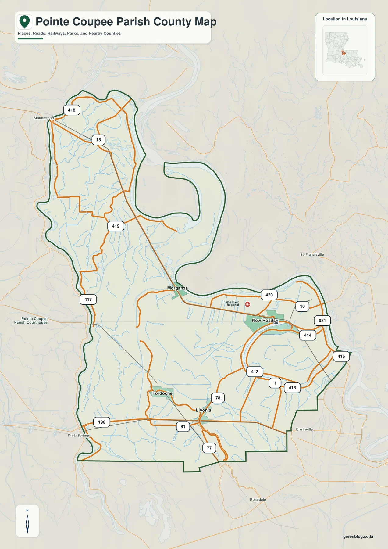
New Roads is the parish seat. Louisiana’s official Pointe Coupee Parish profile lists New Roads as the city, Fordoche and Livonia as towns, and Morganza as a village. On the general map, New Roads stands out near the eastern half of the parish, Livonia lies south, Fordoche is southwest, and Morganza sits to the northwest near the narrow middle section. Locating those four places first makes the roads and irregular parish boundary much easier to understand.
Table of Contents
New Roads sits at the most obvious road junction in the parish
The road pattern around New Roads is denser than in most other parts of Pointe Coupee Parish. LA 1 and LA 10 are prominent references, and routes such as LA 413, 414, 415, and 416 branch through the eastern section. Toward Morganza, the network continues northwest, while the route pattern toward Livonia and Fordoche turns south and southwest. Starting with New Roads keeps the large number of state-road shields from becoming confusing.
Farther north, LA 15 and LA 418 provide major references, and LA 417 follows part of the western side. LA 419 crosses the central section south of Morganza. In the lower parish, U.S. 190 reaches the Livonia area and continues toward Krotz Springs. The map is useful for geographic orientation, but live construction, closures, and travel times should still be checked through Louisiana DOTD or another current transportation source.
Morganza and Livonia help divide the long northern section from the wider south
Morganza lies northwest of New Roads near the narrow central neck of the parish. North of it, the boundary becomes long and relatively slim, with roads and waterways extending through a mostly rural landscape. Moving east from Morganza toward New Roads, the road network becomes more concentrated and the large river bends on the eastern side become increasingly important for orientation.
Livonia provides the opposite reference in the southern half, with Fordoche farther west. U.S. 190 and routes such as LA 78, 81, and 77 help organize this broader lower section. Compared with the narrow north, the southern parish spreads much farther east and west. That change in shape is easy to miss if the area is imagined as a simple north-south rectangle.
Straight-line distances from New Roads show how the communities spread out
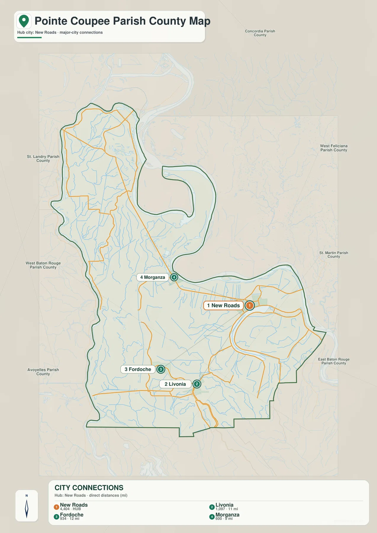
The city-connections map uses New Roads as the hub and compares Morganza, Livonia, and Fordoche. The legend shows approximately 5 miles to Morganza, 11 miles to Livonia, and 12 miles to Fordoche. These are direct straight-line distances between the mapped points, not driving mileage along LA 1, U.S. 190, or local roads. Actual road distance can be longer because of route geometry and river or bayou crossings.
The directions add just as much information as the numbers. Morganza is northwest of New Roads, Livonia is south, and Fordoche is southwest. The simplified connections view therefore reveals a hub-and-spoke pattern without the distraction of small road labels. It is especially useful for a classroom or presentation when the goal is to explain the relative positions of the parish’s main incorporated communities.
The Atchafalaya River and northern bayous organize the western water network
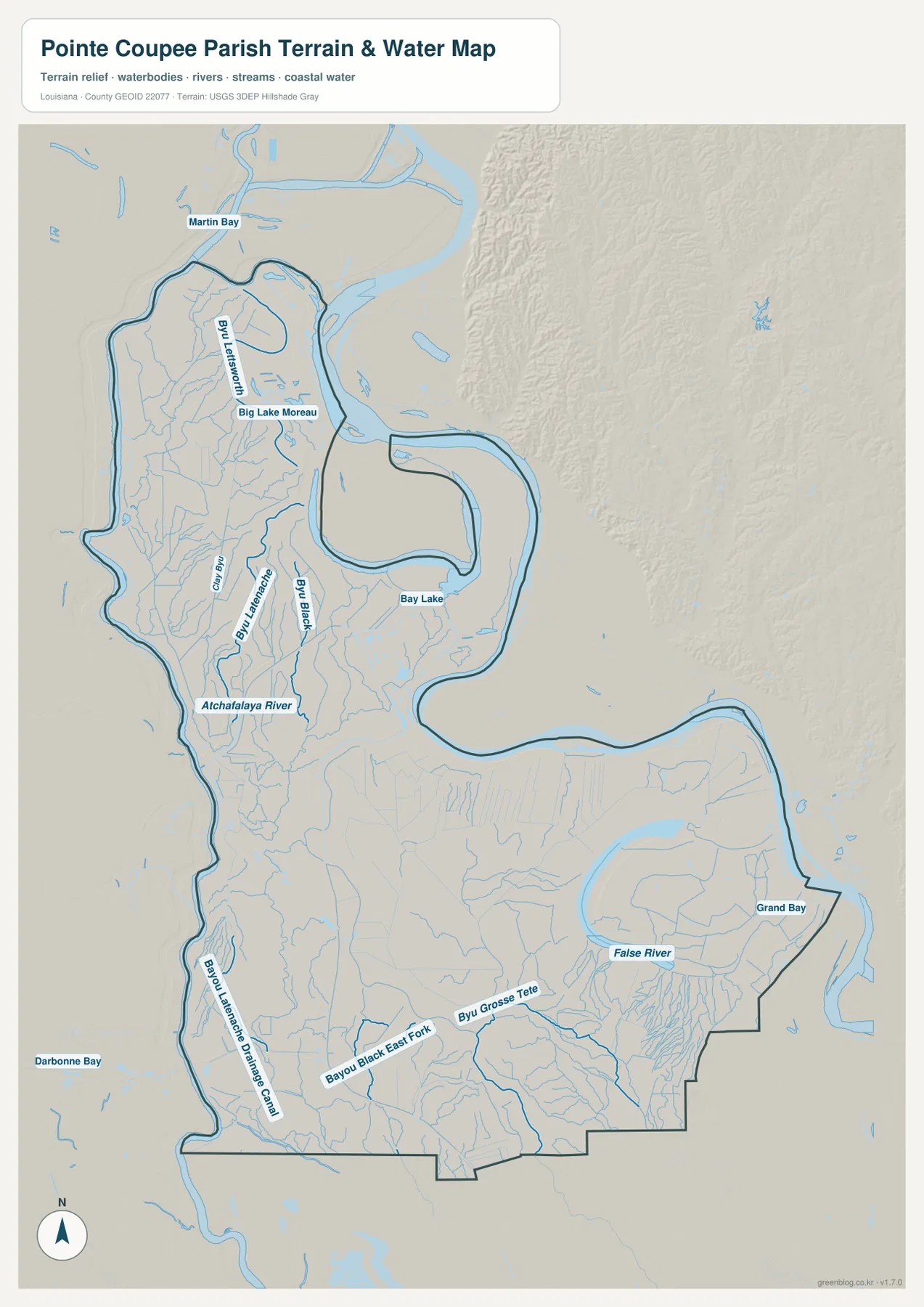
The terrain-and-water map makes the western hydrology much easier to see. The Atchafalaya River runs along or near the western side, while Bayou Latanache and Bayou Black extend through the interior. Big Lake Moreau and Martin Bay appear in the north, surrounded by many smaller tributaries. Areas that look relatively open on the road map are therefore crossed by a dense network of water channels.
Bayou Latanache continues through the west-central section, and the Bayou Latanache Drainage Canal is labeled farther south. Bayou Black provides another long north-south reference through the interior. Because natural bayous, rivers, canals, lakes, and bays all appear on the same map, the labels should be used primarily for location rather than assuming that each blue feature has the same origin or function.
False River and Bayou Grosse Tete define the water geography around New Roads and the south
False River is the most recognizable water feature around New Roads. Its long curved shape lies immediately east and southeast of the city and provides a natural landmark that is easier to identify than many of the smaller roads. The Mississippi River forms large bends along the eastern side of the parish. Louisiana DOTD’s John James Audubon Bridge project description confirms that LA 10 crosses the Mississippi from Pointe Coupee Parish on the west bank toward West Feliciana Parish on the east bank.
Farther south, Bayou Black East Fork and Bayou Grosse Tete become important references, with Grand Bay on the eastern side. Bay Lake is labeled farther north, while Darbonne Bay appears beyond the western boundary. The water map is intended for general geographic reference only. It does not provide flood-zone classifications, water depth, navigability, levee conditions, or legal property boundaries.
Different landmarks work better in the narrow north and the wider south
Pointe Coupee Parish changes shape noticeably from north to south. In the northern section, LA 15, LA 418, the Atchafalaya River, and Big Lake Moreau provide useful references. Around the middle, Morganza and New Roads help connect the narrow upper parish to the much wider lower section. In the south, Livonia, Fordoche, U.S. 190, and Bayou Grosse Tete make the broad rural landscape easier to organize.
The best map depends on the question. The general map is the clearest choice for roads, communities, and the boundary; the city-connections view is useful for comparing directions and straight-line distance from New Roads; and the water map gives the Atchafalaya River, False River, bayous, lakes, and bays enough space to be read clearly. Small labels are easier to inspect in the original JPG than in a browser preview.
High-resolution JPG files keep the smaller road and water labels readable
The downloadable ZIP contains the three original JPG files corresponding to the previews on this page: the general parish map, the city-connections map, and the terrain-and-water map. Each original image is 2572 by 3638 pixels, providing more room to inspect road shields, settlement labels, bayou names, and lake labels than the web preview. The files are useful for printing, classroom material, presentation slides, and personal geographic reference.
Choose the general map when New Roads, the road network, and the parish outline need to appear together. Use the city-connections graphic for Morganza, Livonia, and Fordoche relative to New Roads. The terrain-and-water map is better for the Atchafalaya River, False River, Bayou Latanache, Bayou Black, and Bayou Grosse Tete. These are general reference maps rather than legal boundary, survey, flood-risk, or real-time navigation products.
Frequently Asked Questions
What is the parish seat of Pointe Coupee Parish?
New Roads is the parish seat. Louisiana’s official profile lists New Roads as the city and administrative center, with Fordoche and Livonia as towns and Morganza as a village. On the map, New Roads is also a useful reference because several major state routes converge near False River.
Are the 5-, 11-, and 12-mile labels driving distances?
No. The city-connections map uses straight-line distances from New Roads: about 5 miles to Morganza, 11 miles to Livonia, and 12 miles to Fordoche. Actual driving distance depends on the selected road and the route around rivers, bayous, and local road geometry.
Can the False River and Atchafalaya River map be used for flood or navigation decisions?
No. The water map is a general geographic reference showing the relative positions of rivers, bayous, lakes, canals, and bays. It does not provide flood-zone ratings, water depth, navigability, levee status, or legal property boundaries. Those decisions require current official hazard and navigation data.
Map File Information
The ZIP contains the original high-resolution JPG files corresponding to the general parish map, city-connections map, and terrain-and-water map shown on this page.
- Included Files: parish map JPG, city-connections map JPG, terrain-and-water map JPG
Related Maps
Sources and references
For parish-seat and municipality information, see the Louisiana.gov Pointe Coupee Parish Profile. Official transportation references include Louisiana DOTD Maps and the John James Audubon Bridge project page. General boundary data are documented by the U.S. Census Bureau TIGER/Line Shapefiles, and national water-feature data are documented through USGS National Hydrography.
Green Map creates custom-edited map images using open geographic data sources such as geoBoundaries, Natural Earth, OpenStreetMap, and government open data. These maps are edited visual materials, not raw data files, and are provided for education, documents, presentations, and graphic reference.