Orleans Parish is unusual among Louisiana parishes because the urban core of New Orleans shares one administrative footprint with a large amount of open water and wetland. The map places the dense city near the great bend of the Mississippi River, Lake Pontchartrain across the north, and a long eastern extension of marshes and canals reaching toward the Rigolets. This page uses the supplied boundary, city-index, and terrain-and-water maps to explain those contrasts. Matching high-resolution JPG originals are available together in a downloadable ZIP.
Orleans Parish and the City of New Orleans are coterminous for practical administrative mapping, which is why the city index contains only one major city: New Orleans. That makes this page different from parish maps that compare several incorporated towns. The useful comparison here is internal—between the tightly developed southwest, the broad Lake Pontchartrain water area in the north, and the canal-and-marsh landscape farther east.
Table of Contents
New Orleans occupies the dense southwest beside the Mississippi River bend
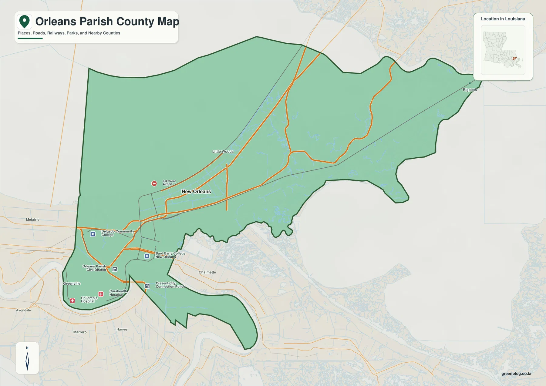
The general parish map shows the developed New Orleans area concentrated in the southwest. The Mississippi River curves around this urban core, giving the lower part of the parish its familiar crescent-like geography. Across and beyond the river are neighboring communities in Jefferson and St. Bernard parishes, while the Orleans Parish boundary continues north and east well beyond the densest street grid.
Several mapped facilities help with orientation. New Orleans Lakefront Airport appears northeast of the downtown core near the south shore of Lake Pontchartrain, and institutions such as the University of New Orleans and Delgado Community College are labeled in the urban area. These points are not meant to replace street navigation, but they make it easier to see how the city stretches from the river toward the lake.
The eastern parish changes quickly from city streets to marsh and canals
Moving east from the main New Orleans urban area, the map becomes much less road-dense. Little Woods is one of the labeled communities near the transition, and beyond it the parish extends through a broad low-lying landscape toward the Rigolets. The boundary narrows and bends around water features rather than following a simple rectangular edge, making the eastern section look very different from the compact city blocks in the southwest.
Lake Pontchartrain also changes how the parish’s size should be interpreted. A large part of the northern mapped boundary covers water rather than developed land. In other words, the parish polygon is much larger than the built-up city footprint. Reading the shoreline and water boundary together prevents the common mistake of assuming that all of the shaded parish area is urban land.
The city index contains only New Orleans
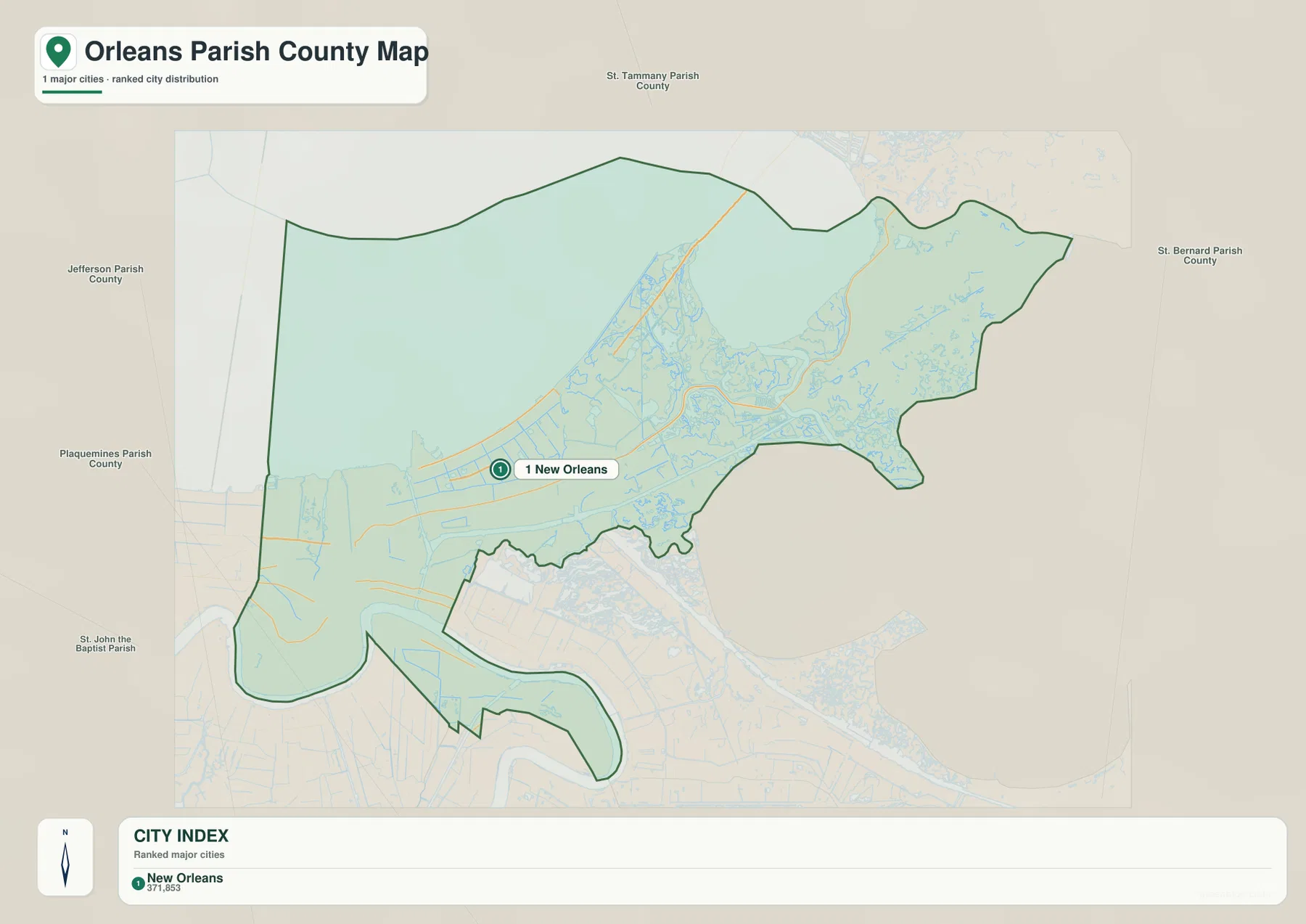
The city-index graphic is intentionally simple. New Orleans is the only ranked major city, so the number 1 marker should not be read as one entry in a long list of separate municipalities inside the parish. Instead, it reflects the fact that Orleans Parish and New Orleans share the same overall administrative area. The map is therefore most useful as a way to compare the city label with the full parish outline.
That outline makes the internal geography especially clear. The New Orleans marker sits in the southwest, while the parish continues far north over Lake Pontchartrain and far east across marsh and canal country. With most road and facility labels removed, the city index gives a cleaner sense of just how small the dense urban core is compared with the parish’s total mapped footprint.
Lake Pontchartrain and the Mississippi River frame the urban parish
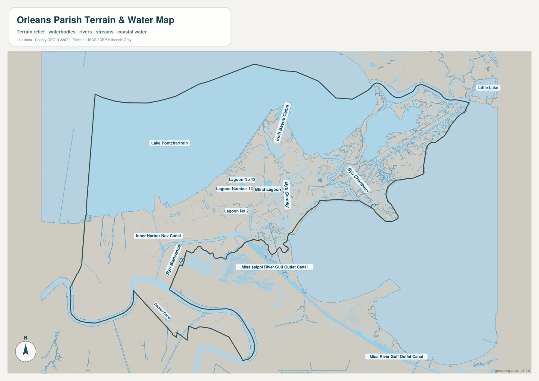
The terrain-and-water map makes the parish’s two largest water references impossible to miss. Lake Pontchartrain occupies a broad area across the north, while the Mississippi River sweeps around the developed southwest. The city therefore sits between a major lake and a major river, and much of the local drainage and canal network connects back to that low-lying setting.
On the lake side, Irish Bayou Canal and several smaller channels extend through the northern and northeastern section. Along the river and lower urban edge, navigation and drainage corridors intersect a heavily modified landscape. The water-focused map strips away much of the street detail, making it easier to see how frequently canals, bayous, lagoons, and open water interrupt the land surface.
Inner Harbor Navigation Canal and Bayou Bienvenue divide the city from the eastern wetlands
One of the strongest artificial waterways is the Inner Harbor Navigation Canal, which runs north-south through the eastern side of the developed city. Bayou Bienvenue lies farther south and east, while Bayou Gentilly and Irish Bayou Canal provide additional references in the northeastern area. Together they show how the transition from urban New Orleans to the eastern wetlands is crossed by both natural bayous and engineered channels.
The Mississippi River Gulf Outlet Canal is labeled across the southeastern section of the water map. Its historic role as a navigation channel does not mean that this general reference map can answer current navigation, depth, or access questions. The same caution applies to other blue areas on the map: they show relative water locations, not flood-zone classifications, levee protection, navigable depth, or legal property boundaries.
Reading west to east makes the parish easier to understand
A practical way to orient yourself is to begin with the dense New Orleans urban area in the southwest. From there, move north toward Lakefront Airport and the south shore of Lake Pontchartrain, then east toward Little Woods and the increasingly wet landscape beyond. The Rigolets side of the parish is much farther from the central city than the street grid might suggest when viewed without the full boundary.
For water features, use Lake Pontchartrain and the Mississippi River as the two largest anchors. Inner Harbor Navigation Canal helps separate the urban core from the eastern side, while Bayou Bienvenue, Bayou Gentilly, and Irish Bayou Canal make the wetland section easier to follow. This method is more useful than trying to read every small canal label at once, especially on a phone or small browser window.
High-resolution JPG files make small roads and canal labels easier to inspect
The downloadable ZIP contains the original JPG files corresponding to the three previews on this page: the general parish map, the city-index map, and the terrain-and-water map. Each original image is 3638 by 2572 pixels, providing more room to inspect small road, facility, bayou, and canal labels than the web preview. The files are useful for printing, classroom material, presentation slides, and personal geographic reference.
Choose the general map when you need the city, roads, facilities, and parish boundary together. Use the city-index graphic when the relationship between New Orleans and the full Orleans Parish footprint is the main subject. The water map is better for Lake Pontchartrain, the Mississippi River, Inner Harbor Navigation Canal, Bayou Bienvenue, and the eastern wetlands. These are general reference maps rather than legal boundary, survey, flood-risk, or real-time navigation products.
Frequently Asked Questions
Are Orleans Parish and the City of New Orleans the same area?
For current administrative mapping, Orleans Parish and the City of New Orleans are coterminous. That is why the supplied city index contains only one major city, New Orleans, instead of several separate incorporated municipalities.
Why does the Orleans Parish boundary include so much of Lake Pontchartrain?
The parish boundary extends beyond the shoreline and includes a large area of Lake Pontchartrain water. As a result, the full mapped parish footprint is much larger than the developed land area of New Orleans, especially across the northern section.
Can the terrain-and-water map be used for flood or navigation decisions?
No. It is a general geographic reference showing the relative positions of Lake Pontchartrain, the Mississippi River, canals, and bayous. It does not provide flood-zone ratings, water depth, levee-protection status, navigability, or legal property boundaries. Those decisions require current official hazard and navigation data.
Map File Information
The ZIP contains the original high-resolution JPG files corresponding to the general parish map, city-index map, and terrain-and-water map shown on this page.
- Included Files: parish map JPG, city-index map JPG, terrain-and-water map JPG
Related Maps
Sources and references
For local administrative information, see the City of New Orleans official website. General boundary data are documented by the U.S. Census Bureau TIGER/Line Shapefiles, while national river, lake, bayou, and canal data are documented through USGS National Hydrography.
Green Map creates custom-edited map images using open geographic data sources such as geoBoundaries, Natural Earth, OpenStreetMap, and government open data. These maps are edited visual materials, not raw data files, and are provided for education, documents, presentations, and graphic reference.