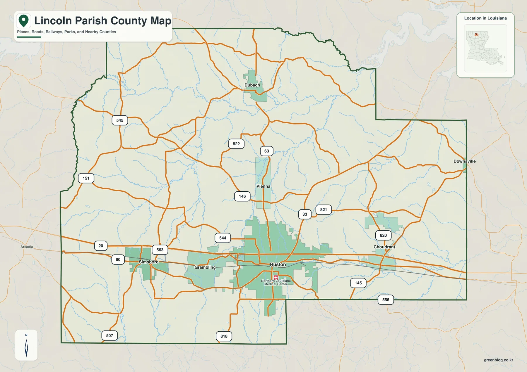
Lincoln Parish in north Louisiana is easiest to recognize by the developed Ruston–Grambling area and the east-west I-20 corridor that also connects Simsboro and Choudrant. North of that corridor, Vienna and Dubach sit in a more lightly developed part of the parish, while Downsville is separated from the main urban cluster near the eastern edge. This page uses those visible relationships to explain the parish, then follows the creek system shown on the terrain-and-water map. The matching high-resolution JPG map files can be downloaded together in a ZIP.
Ruston is the parish seat and the strongest orientation point on the supplied maps. Louisiana’s official Lincoln Parish profile lists Ruston and Grambling as cities, Dubach and Vienna as towns, and Choudrant, Downsville, and Simsboro as villages. On the general map, however, those places do not form an even scatter. Ruston has the largest developed footprint, Grambling lies close to its west, and the remaining communities are distributed along the I-20 corridor or farther north and east.
Table of Contents
I-20 ties the parish together from Simsboro through Ruston to Choudrant
The clearest transportation pattern is the I-20 corridor across the southern half of Lincoln Parish. Simsboro sits near the western side, followed by Grambling and the much larger Ruston urban area. Choudrant is farther east on the same broad axis. This sequence gives the parish a strong east-west reference line even though its boundary extends much farther north. Once I-20 and Ruston are located, the smaller roads and outlying communities are easier to place in relation to the main population center.
Several state routes add local connections around the interstate. LA 33, LA 544, and LA 146 appear around Ruston, while LA 563 and LA 80 are labeled in the Simsboro area. Near Choudrant, LA 820, LA 821, and LA 145 connect the eastern side, and routes such as LA 818 and LA 556 extend along the south. These roads are useful for geographic orientation, but the map is not a live traffic product. Current construction, closures, and travel conditions should be checked through Louisiana DOTD or another up-to-date navigation source.
Vienna and Dubach form the northern branch while Downsville sits apart in the east
North of Ruston, the settlement pattern becomes less dense. Vienna lies close enough to Ruston to feel connected to the central area, while Dubach is much farther north and stands out as the main labeled community in the upper parish. LA 63 provides a clear north-south road reference through this part of the map, with LA 822 and other local roads branching from it. Compared with the I-20 corridor, the northern section contains more open space and a much larger number of small drainage lines.
Downsville occupies a different position near the eastern projection of the parish boundary. The outline makes several step-like turns on that side instead of following a simple rectangle, and the area between Choudrant and Downsville contains more roads and streams than developed urban blocks. Neighbor labels also help with orientation: Jackson, Bienville, and Claiborne parishes are shown to the west, while Ouachita and Union are identified on the east and northeast sides.
The ranked city view emphasizes Ruston and Grambling instead of distance lines
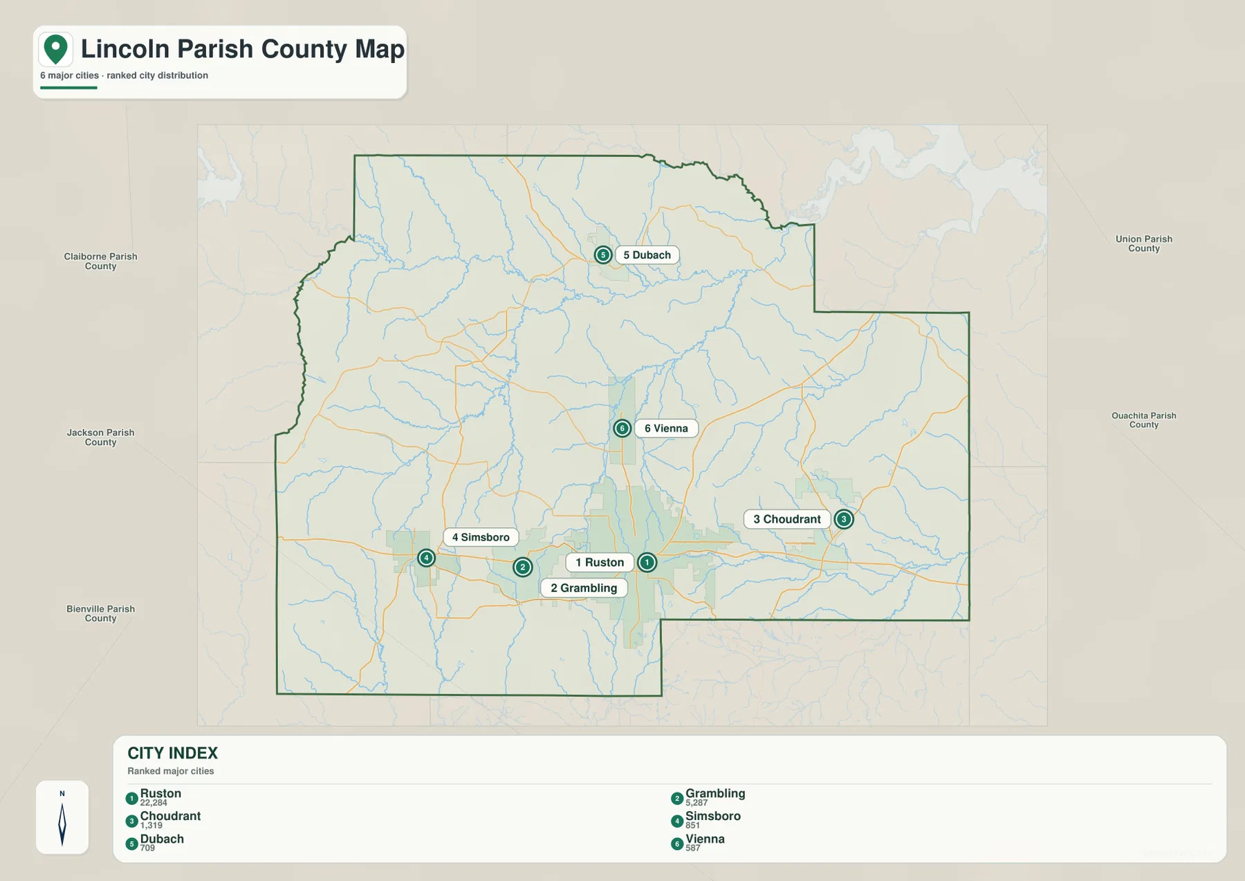
The city map is a ranked distribution graphic rather than a hub-and-distance diagram. Ruston is marked number 1 and Grambling number 2, followed by Choudrant, Simsboro, Dubach, and Vienna. That ordering makes the Ruston–Grambling area immediately stand out as the largest concentration among the six selected places. Choudrant and Simsboro occupy opposite sides of the I-20 corridor, while Dubach and Vienna show how the settlement pattern extends north from the central urban area.
Downsville appears on the general parish map but is not one of the six entries in the city index. That difference is useful because it shows what each map is meant to do. The general map gives broader place and road coverage, while the ranked city view strips away many labels so the selected communities are easier to compare. For locating every named community, use the general map; for a quick picture of the six ranked settlements, the city graphic is cleaner.
Bayou D’Arbonne and Big Creek define much of the northern and central drainage
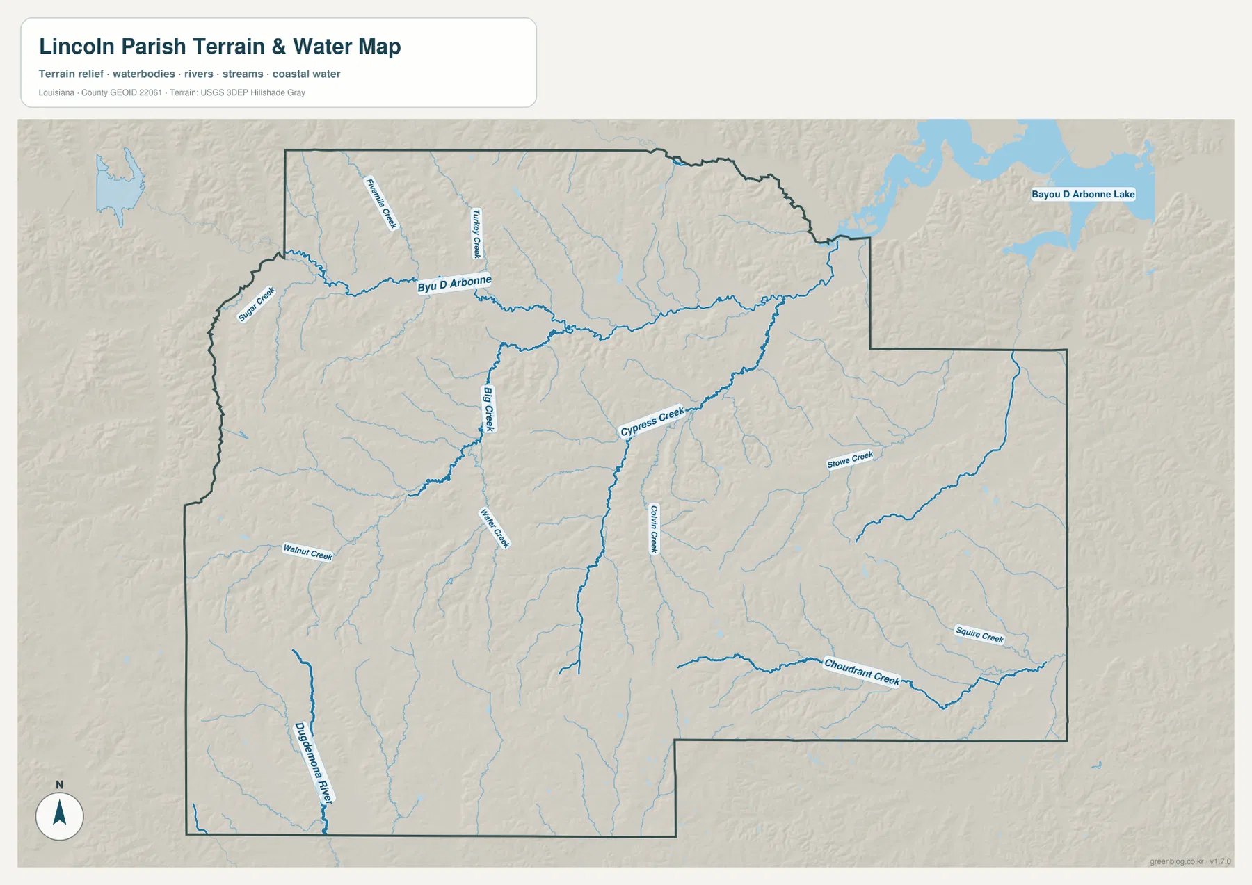
The terrain-and-water map changes the visual emphasis completely. Bayou D’Arbonne runs across the northern part of the parish, with Sugar Creek, Fivemile Creek, and Turkey Creek feeding or approaching that system from nearby areas. Farther south, Big Creek forms a strong north-south reference in the west-central section and is joined by a dense network of smaller tributaries. The open-looking area between Dubach and Vienna on the road map is therefore not empty; it is crossed by many narrow stream channels.
Bayou D’Arbonne Lake is labeled beyond the northeastern parish boundary on the supplied water map. The lake is visually prominent because of its broad blue surface, but the map places the main lake body outside Lincoln Parish while Bayou D’Arbonne and its tributaries cross the northern part of the parish itself. That distinction matters when using the map for location reference. Precise legal shoreline or jurisdiction questions should be checked against current official boundary data rather than inferred from a general-purpose map.
Cypress Creek, Choudrant Creek, and the Dugdemona River separate the eastern and southern watersheds
Cypress Creek is one of the strongest labeled water features in the center-east portion of Lincoln Parish. Slowe Creek and Sallee Creek appear farther east, while Choudrant Creek bends across the southeastern area below the community of Choudrant. Removing the road labels in this water-focused view makes it much easier to see how these streams occupy different parts of the parish instead of merging into one simple channel.
The southwest has a different reference feature: the Dugdemona River runs near the boundary, with Walnut Creek and numerous smaller tributaries spread through the surrounding terrain. The overall network shows that Lincoln Parish drains through several named creeks and bayous rather than one dominant river. This map is intended for general geographic reference only. It does not show flood-zone classifications, water depth, navigability, parcel boundaries, or survey-grade locations.
Road and water landmarks give different shortcuts for finding places
For a quick orientation, start with the Simsboro–Grambling–Ruston–Choudrant sequence along I-20. From Ruston, move north to Vienna and then Dubach, or follow the eastern side toward Downsville. For water features, use Bayou D’Arbonne in the north, Big Creek and Cypress Creek through the middle, Choudrant Creek in the southeast, and the Dugdemona River in the southwest. These anchors reduce the need to read every small label at once.
The three supplied map types are therefore useful for different questions. The general parish map combines settlements, roads, and the boundary; the ranked city graphic simplifies the six selected communities; the terrain-and-water map gives creek and drainage names much more space. On a phone or small browser window, some of the route numbers and tributary labels can be difficult to read, so enlarging the original JPG is especially helpful for the denser sections around Ruston and the creek network.
Original JPG files preserve the smaller road and stream labels
The downloadable ZIP contains the three original JPG files corresponding to the previews on this page: the general parish map, the ranked city map, and the terrain-and-water map. Each original image is 3638 by 2572 pixels, providing substantially more room to inspect road numbers, community labels, creek names, and the irregular parish boundary than the web preview. The files work well for printing, classroom material, presentation slides, or personal geographic reference.
Choose the general map when you need settlements and roads together. Use the city index when the relationship among Ruston, Grambling, Choudrant, Simsboro, Dubach, and Vienna is the main subject. The water map is the better choice for Bayou D’Arbonne, Cypress Creek, Choudrant Creek, the Dugdemona River, or the lake area to the northeast. These are reference maps rather than legal boundary, surveying, flood-risk, or real-time navigation products.
Frequently Asked Questions
Which place is the best starting point for reading the Lincoln Parish map?
Ruston is the easiest starting point because it is the parish seat, has the largest developed footprint on the map, and lies on the I-20 corridor near Grambling. From Ruston, you can trace west toward Simsboro, east toward Choudrant, north toward Vienna and Dubach, or farther east toward Downsville.
Why is Downsville missing from the ranked city index?
The city graphic is not intended to list every community in Lincoln Parish. It selects six ranked places—Ruston, Grambling, Choudrant, Simsboro, Dubach, and Vienna—while the general parish map provides broader place coverage and also labels Downsville. Use the general map when you need the wider set of communities.
Is Bayou D’Arbonne Lake inside Lincoln Parish?
On the supplied terrain-and-water map, the main labeled lake body is shown beyond the northeastern Lincoln Parish boundary, while Bayou D’Arbonne and several tributaries cross the northern part of the parish. For an exact legal boundary or shoreline determination, use current official jurisdiction and boundary data rather than this general reference map.
Map File Information
The ZIP contains the original high-resolution JPG files corresponding to the general parish map, ranked city map, and terrain-and-water map shown on this page.
- Included Files: parish map JPG, ranked city map JPG, terrain-and-water map JPG
Related Maps
Sources and references
For parish-seat and municipality information, see the Louisiana.gov Lincoln Parish Profile and the Lincoln Parish Police Jury. Current state-road information is available from the Louisiana DOTD Lincoln Parish page. General boundary data are documented by the U.S. Census Bureau TIGER/Line Shapefiles, and national water-feature data are documented through USGS National Hydrography.
Green Map creates custom-edited map images using open geographic data sources such as geoBoundaries, Natural Earth, OpenStreetMap, and government open data. These maps are edited visual materials, not raw data files, and are provided for education, documents, presentations, and graphic reference.