Franklin Parish lies in northeastern Louisiana, with Winnsboro serving as the main reference point for reading the area. Baskin is north of Winnsboro, while Gilbert and Wisner extend southward, so the parish’s principal communities form a clear north–south sequence. The maps on this page combine settlement locations, roads, parish boundaries, waterways, and named lakes. Matching high-resolution JPG versions of the displayed maps can also be downloaded together in one ZIP file below. High-resolution map files are available for download in the section below.
The parish becomes easier to understand once the road and water maps are compared. U.S. 425 and several state routes organize travel around Winnsboro, but the water map reveals a much denser landscape of creeks, bayous, sloughs, and lakes. Turkey Creek is prominent across the northern and central sections, Bayou Macon runs along the eastern side, and a chain of named lakes stands out in the east and southeast.
Table of Contents
Winnsboro as the Main Reference Point
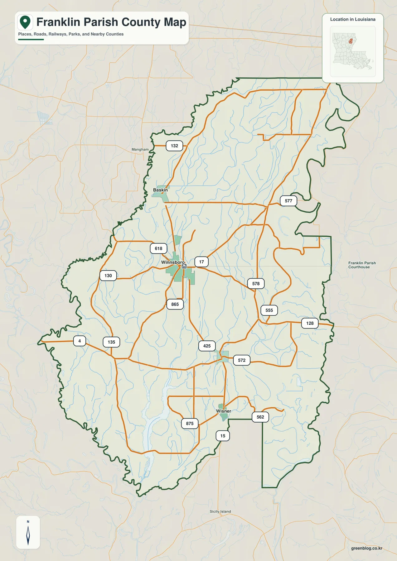
Winnsboro sits near the middle of Franklin Parish and is the easiest place to use as an anchor when reading the county-style base map. Several numbered routes meet or pass close to the city, and the Louisiana state profile identifies Winnsboro as the parish seat. From this central point, Baskin lies to the north, Gilbert appears farther south, and Wisner is located closer to the southern part of the parish.
The base map also makes the parish outline easy to follow. Much of the western and eastern boundary bends rather than forming a simple rectangle, while the southeastern section includes a narrow projection. These irregular edges are useful orientation clues when the parish is viewed beside neighboring areas, especially because the internal road network is more regular than the outer boundary.
Roads Linking Winnsboro, Baskin, Gilbert, and Wisner
The road network is most concentrated around Winnsboro. U.S. 425 is one of the clearest long-distance reference routes on the map, while routes numbered 17, 130, 132, 135, 555, 577, 578, and others provide local connections across the parish. Rather than trying to follow every route at once, it is more useful to begin at Winnsboro and trace one direction at a time toward the northern, southern, eastern, or western sections.
The map is intended for general geographic reference, not real-time navigation. It does not show temporary closures, construction, traffic conditions, or turn-by-turn directions. Its value is in showing how communities and route corridors relate to one another across the parish, which makes it suitable for school projects, regional introductions, printed reference material, and pre-trip orientation.
A North–South Community Pattern
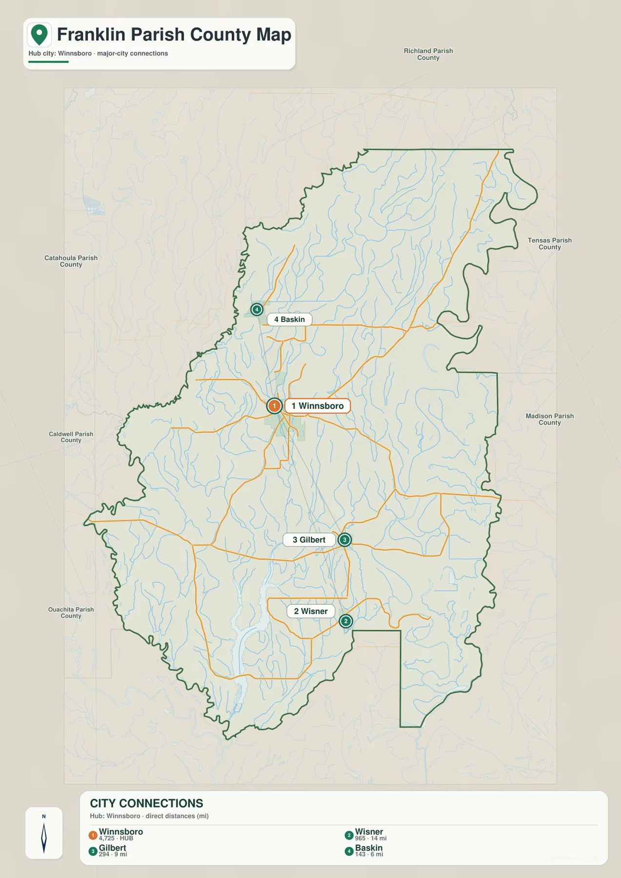
Baskin, Winnsboro, Gilbert, and Wisner form a simple sequence when the smaller roads are reduced in the city-connections map. Baskin is positioned north of Winnsboro and closer to the western edge of the parish. Gilbert lies south of Winnsboro, and Wisner continues the sequence farther south. This arrangement makes the parish’s settlement pattern easy to explain without the extra detail of every road and stream.
The city map uses Winnsboro as the hub and labels direct distances to the other three communities. Baskin is shown at about 6 miles, Gilbert at about 9 miles, and Wisner at about 14 miles from Winnsboro. These are straight-line distances used for geographic comparison, not driving distances along the road network. Actual travel mileage and time can be longer depending on the route chosen.
Neighboring Parishes Around Franklin Parish
The city map also provides useful regional context by labeling neighboring parishes around the frame. Richland Parish appears to the north, Tensas Parish and Madison Parish are to the east, and Catahoula Parish and Caldwell Parish lie to the west. Ouachita Parish is shown toward the southwest. These labels help place Franklin Parish within northeastern Louisiana even when a statewide map is not open beside it.
The boundary shown here should still be treated as a general reference rather than a legal survey. Property ownership, jurisdiction questions, parcel boundaries, and official boundary determinations require current government records. U.S. Census Bureau TIGER/Line files are an appropriate official source for checking administrative geography and transportation features when more precise data is needed.
Turkey Creek Across the Northern and Central Parish
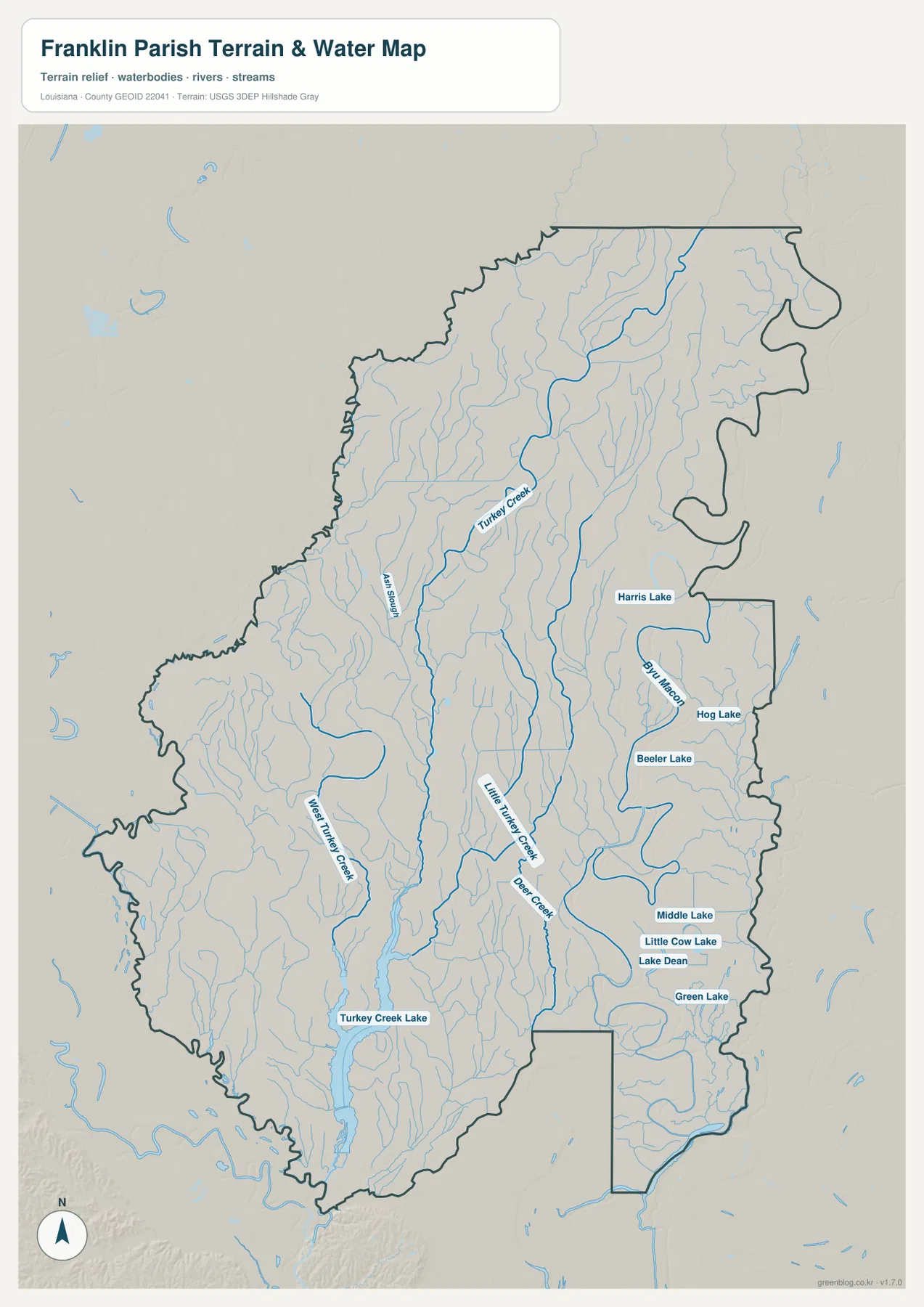
Turkey Creek is one of the most prominent named waterways on the terrain-and-water map. It runs through the northern and central parts of Franklin Parish and is joined by many smaller channels. Ash Slough is labeled west of the main creek, while numerous unnamed tributaries show how densely drained this part of the parish is. The contrast with the road map is significant: roads appear comparatively sparse, while streams occupy much of the interior.
Farther south, the map distinguishes Lost Turkey Creek and Little Turkey Creek rather than treating all similarly named channels as one continuous waterway. Those labels are useful when comparing different portions of the parish because the waterways branch and occupy separate corridors. For readers interested in natural features, the water map therefore provides much more detail than the base map.
Bayou Macon and the Eastern Lakes
Bayou Macon is the strongest water reference along the eastern side of Franklin Parish. It follows a winding course through the east and is accompanied by several named lakes. Harris Lake, Hog Lake, and Beeler Lake appear in the eastern section, while Middle Lake, Little Cow Lake, Lake Dean, and Green Lake are grouped farther south. Together they make the eastern side visually distinct from the central road corridor around Winnsboro.
These mapped lakes are useful for understanding location, but the map does not provide depth, boat access, ownership, fishing regulations, or current water levels. Anyone planning recreation should consult current local or state information before traveling. On this page, the lakes are best used as geographic landmarks that help explain how the Bayou Macon side of the parish differs from the road-focused center.
Turkey Creek Lake and the Southwestern Water Network
Turkey Creek Lake is the largest named water feature that stands out in the southwestern part of the map. Its long shape lies close to the parish boundary and connects visually with the broader Turkey Creek system to the north. This makes it a useful landmark when comparing the western half of Franklin Parish with the lake-rich eastern side.
Lost Turkey Creek and many smaller channels also cross the western and southwestern sections. On the base map, this part of the parish is dominated by roads and the irregular outer boundary, but the water map reveals how much of the same area is threaded by drainage channels. Placing the two maps side by side is an effective way to show why one representation cannot answer every geographic question.
Deer Creek and Little Turkey Creek South of the Center
The area between Gilbert and Wisner becomes more detailed when viewed on the water map. Deer Creek and Little Turkey Creek cross the central-southern portion of the parish and are joined by smaller tributaries. East of them, the Bayou Macon system and associated lakes create another dense concentration of water features.
This contrast is a good example of how the city-connections map and terrain-and-water map serve different purposes. The city map reduces the landscape to four major communities and their relative locations, while the water map removes most of that visual emphasis and brings creeks, lakes, and drainage lines forward. The base map sits between the two by combining roads, settlements, boundaries, and general hydrography.
What the Terrain Shading Does and Does Not Show
The terrain-and-water map includes subtle shaded relief behind the waterways. This provides a visual sense of broad surface variation without turning the map into a technical elevation product. Franklin Parish appears generally low and gently varying rather than mountainous, and the dense network of streams is more visually important than any steep relief.
The shaded background should not be used to read exact elevations at specific locations. Engineering design, drainage studies, construction planning, or precise elevation work requires dedicated elevation data such as the U.S. Geological Survey 3D Elevation Program. Likewise, flood risk should be checked with current official flood information rather than inferred from the presence of streams or low-looking terrain on this map.
Choosing the Best Map for the Task
For a general introduction to Franklin Parish, the base map is the most complete starting point because it combines Winnsboro, surrounding communities, numbered roads, the parish boundary, and many streams. It works well when the reader needs a single overview rather than a specialized view.
The city-connections map is better when the goal is to explain where Baskin, Gilbert, and Wisner sit in relation to Winnsboro. Its straight-line distance labels make quick comparison easy, provided they are not mistaken for driving mileage. The terrain-and-water map is the better choice for Turkey Creek, Bayou Macon, Deer Creek, Turkey Creek Lake, and the eastern chain of lakes because it gives water features much more visual emphasis.
High-Resolution JPG Download Files
The download archive contains three original JPG images corresponding to the maps shown in the article: the parish base map, the city-connections map, and the terrain-and-water map. Each original image is 2572 × 3638 pixels in portrait orientation. These files are larger than the WebP previews used on the page, which makes them more useful for zooming, printing, classroom handouts, and presentation slides.
Because all three source images use the same dimensions, they can be swapped into a consistent page or slide layout without changing the basic frame. They remain general-reference maps, however, and should not be used as substitutes for legal boundary records, parcel maps, survey data, flood determinations, or real-time transportation information.
Frequently Asked Questions
What is the easiest place to use as a reference point in Franklin Parish?
Winnsboro is the most practical starting point. It is the parish seat, appears near the center of the mapped road network, and serves as the hub on the city-connections map. From Winnsboro, Baskin is north, Gilbert is south, and Wisner is farther south.
Are the 6-, 9-, and 14-mile labels on the city map driving distances?
No. They are straight-line distances from Winnsboro used to compare relative location. The map shows Baskin at about 6 miles, Gilbert at about 9 miles, and Wisner at about 14 miles. Driving distance and travel time depend on the roads used and can be longer.
Which map is best for Turkey Creek and Bayou Macon?
The terrain-and-water map is the best choice because it emphasizes Turkey Creek, Lost Turkey Creek, Little Turkey Creek, Deer Creek, Bayou Macon, Turkey Creek Lake, and the named lakes in the eastern part of the parish. The base map is better when roads and communities need to be shown at the same time.
Map File Information
Download the original high-resolution JPG files corresponding to the parish base map, city-connections map, and terrain-and-water map in one ZIP archive.
- Included Files: parish map JPG, city-connections map JPG, terrain-and-water map JPG
Related Maps
Sources and References
- Louisiana.gov – Franklin Parish Profile: official state information for the parish, including the parish seat and local government links.
- Visit Franklin Parish – About Franklin Parish: local history and community information about Franklin Parish and Winnsboro.
- U.S. Census Bureau – TIGER/Line Shapefiles: official boundary, road, and geographic reference data.
- USGS – National Hydrography: official U.S. hydrography information for streams, rivers, and water bodies.
Green Map creates custom-edited map images using open geographic data sources such as geoBoundaries, Natural Earth, OpenStreetMap, and government open data. These maps are edited visual materials, not raw data files, and are provided for education, documents, presentations, and graphic reference.