Assumption Parish stretches through a low-water landscape in south-central Louisiana, with Napoleonville near the middle, Lake Verret dominating the west-central side, and Bayou Lafourche running along the eastern half. This Assumption Parish Map collection shows Belle Rose, Paincourtville, Pierre Part, Napoleonville, Labadieville, Bayou L’Ourse, the main Louisiana highways, and a dense network of lakes, bayous, and canals.
Readers can review the web previews first and then download a ZIP containing the original high-resolution JPG files. The package includes three themes only: a general parish map, a city-distribution map, and a terrain-and-water map. No elevation map is supplied. Using Napoleonville and Lake Verret as anchors makes the long north–south shape of the parish much easier to follow.
Table of Contents
Napoleonville and LA 1 organize the parish’s central road network
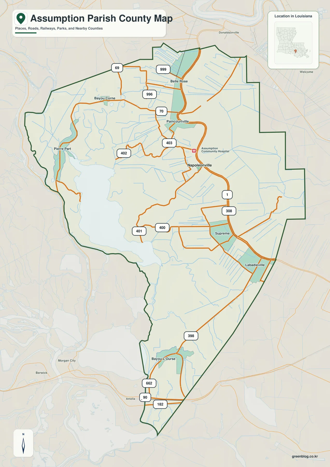
Napoleonville is the clearest place to begin reading the general map. LA 1 comes south from the Belle Rose and Paincourtville side, passes Napoleonville, and continues toward Labadieville. LA 70 provides another important reference near Paincourtville, while LA 308 runs along the eastern side. Together, these routes form the most continuous road framework through the parish.
Belle Rose and Bayou Corne appear in the north, where LA 69, LA 999, and LA 996 connect smaller rural areas. Around Paincourtville, LA 70 and LA 403 intersect, while LA 402 reaches west toward the Lake Verret side. The road pattern becomes increasingly irregular near water and wet lowlands, so the waterways help explain many of the bends seen on the general map.
Farther south, Supreme and Labadieville sit near LA 1 and LA 308, and Bayou L’Ourse marks the southern end of the parish. LA 398, LA 662, US 90, and US 182 provide useful references around that lower section. Morgan City, Berwick, and Amelia appear outside the boundary, showing how the southern end connects toward the St. Mary Parish area.
Pierre Part provides the strongest western contrast. It sits beside Lake Verret, where LA 401, LA 400, and LA 402 wind through a landscape shaped by open water, bayous, and wetlands. The general map is meant for geographic orientation rather than current traffic, road closures, speed limits, or private access.
Napoleonville is the single major-city reference on the city map
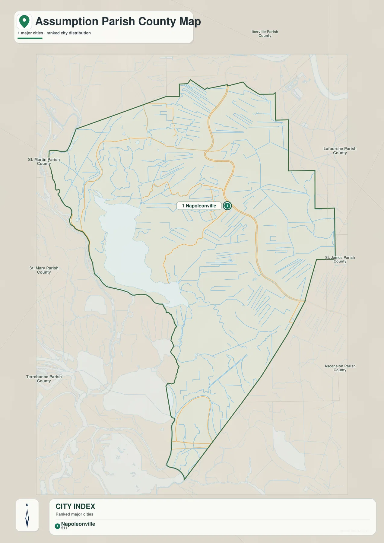
The city-distribution map removes most route detail and highlights Napoleonville as the single major-city reference. Its position near the center makes it useful for understanding the relationship between the northern Belle Rose–Paincourtville area, Pierre Part and Lake Verret to the west, and Labadieville and Bayou L’Ourse farther south.
Louisiana’s official parish profile identifies Napoleonville as the parish seat, and the parish government is also based there. The surrounding labels place Iberville Parish to the north, Lafourche and St. James Parishes to the east, Ascension Parish to the northeast, St. Martin and St. Mary Parishes to the west, and Terrebonne Parish toward the south.
The population value printed in the city index belongs to the source snapshot used to create the map and should not be treated as a current official total. Anyone needing recent demographic figures should consult the U.S. Census Bureau. The purpose of this file is location and regional orientation rather than population ranking.
Lake Verret, Bayou Lafourche, and smaller bayous define the water landscape
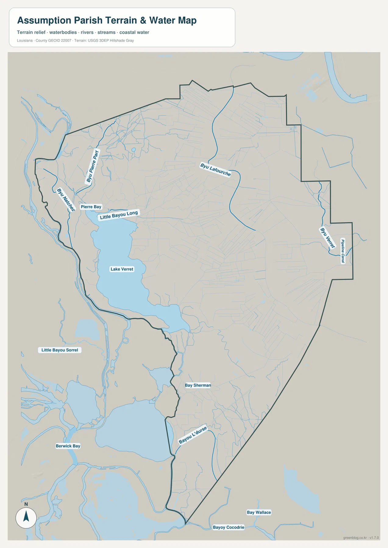
Lake Verret is the largest water feature inside the parish and dominates the west-central side. Pierre Part sits near the lake’s northwestern edge, with Little Bayou Long and Bayou Pierre Part providing additional water references nearby. South of the lake, open water and wet lowlands continue through a complicated network of channels.
Bayou Lafourche runs along the eastern side and is closely associated with the Napoleonville, Supreme, and Labadieville corridor. Bayou Napoleon appears farther north in the interior. The contrast between Lake Verret on the west and Bayou Lafourche on the east makes Assumption Parish easier to understand as a long lowland area divided by multiple waterways rather than one dominant river.
Bay Sherman and Bayou L’Ourse are labeled in the south, while Berwick Bay and Little Bayou Sorrel appear outside the western boundary as regional references. Bayou Cocodrie and Bay Wallace lie near the southern edge, and Bayou Verret and Platten Canal add more named waterways to the northeast. Many smaller blue channels between them suggest an extensive drainage network across farms and wetlands.
This file is a geographic water reference, not a flood-insurance map, depth chart, navigation product, levee-safety document, legal shoreline record, or parcel survey. Current flood, access, and water-level questions should be checked with FEMA, USGS, or local parish sources.
Pierre Part and Napoleonville show two very different parish settings
Pierre Part and the western side are visually dominated by Lake Verret and Bayou Pierre Part. LA 401, LA 400, and LA 402 bend around water and low wetlands, and the map contains more water than road detail in several places. That makes the western section easiest to understand by looking at the general and water maps together.
Napoleonville has a different character on the maps. LA 1, LA 70, and LA 403 provide stronger road references, and the parish hospital label appears nearby. Both the Assumption Parish Police Jury and Louisiana’s official parish profile identify Napoleonville as the parish’s administrative center, matching its central location on the map.
South toward Labadieville and Bayou L’Ourse, waterways again become more prominent. LA 1, LA 308, LA 398, and LA 662 follow the long shape of the parish, while Bayou Lafourche and Bayou L’Ourse occupy separate low corridors. Moving from Belle Rose in the north to Bayou L’Ourse in the south shows just how elongated Assumption Parish is.
Choose the Assumption Parish file by the detail you need
The general map is the best starting point for communities, route numbers, and the parish outline. The city map is cleaner when Napoleonville and neighboring parishes are the main concern. The terrain-and-water map is the strongest choice for Lake Verret, Bayou Lafourche, Bayou Pierre Part, Bayou L’Ourse, and the smaller canal-and-bayou network.
- General map: Use it for Napoleonville, Belle Rose, Paincourtville, Pierre Part, Supreme, Labadieville, Bayou L’Ourse, LA 1, LA 69, LA 70, LA 308, LA 398, LA 400, LA 401, LA 402, LA 403, and LA 662.
- City map: Use it to place Napoleonville relative to Iberville, Lafourche, St. James, Ascension, St. Martin, St. Mary, and Terrebonne Parishes.
- Terrain and water map: Use it for Lake Verret, Bayou Lafourche, Bayou Pierre Part, Bayou Napoleon, Little Bayou Long, Bayou Verret, Bay Sherman, Bayou L’Ourse, and Platten Canal.
Each original JPG measures 2572 × 3638 pixels in portrait orientation, preserving more small road and waterway labels than the web previews. Keeping the original aspect ratio is recommended for printing. When using all three files, start with Napoleonville and Lake Verret, then compare road and water features so the same locations remain easy to follow.
Frequently Asked Questions
Which map is best for Napoleonville, LA 1, and LA 70?
The general parish map is the best choice because it combines Napoleonville with Belle Rose, Paincourtville, Labadieville, LA 1, LA 70, LA 308, LA 403, Pierre Part, and the southern Bayou L’Ourse area in one view.
Where can I see Lake Verret and Bayou Lafourche most clearly?
The terrain-and-water map shows Lake Verret, Bayou Lafourche, Bayou Pierre Part, Bayou Napoleon, Little Bayou Long, Bayou Verret, Bayou L’Ourse, and Platten Canal. It is a geographic reference rather than a flood, depth, navigation, or legal-boundary map.
Why does the city map show only Napoleonville as a major city?
The city-distribution file uses a simplified major-city index and marks Napoleonville as its single city reference. Belle Rose, Paincourtville, Pierre Part, Labadieville, and other communities remain visible on the general map, while current population totals should be checked with the U.S. Census Bureau.
Map File Information
The ZIP contains high-resolution JPG versions of the Assumption Parish general map, city-distribution map, and terrain-and-water map. Use the previews to check Napoleonville, the main roads, Lake Verret, Bayou Lafourche, and Bayou Pierre Part before opening the original files.
- Included Files: Use only the versions confirmed in the article and supplied images
- File Type: Use the confirmed download contents
- Intended Use: Printing, education, presentations, and map-based projects
Related Maps
Sources and references
The geographic discussion is based primarily on the supplied Assumption Parish maps, with official parish and Napoleonville pages plus federal boundary and hydrography sources used for context.
- Assumption Parish Police Jury — official parish government and local information.
- Village of Napoleonville official website — official municipal information and services.
- Louisiana.gov – Assumption Parish — official parish profile and parish-seat information.
- U.S. Census Bureau TIGER/Line Shapefiles — official geographic boundary and road data.
- USGS National Hydrography — federal hydrography background for bayous, lakes, and waterways.
Green Map creates custom-edited map images using open geographic data sources such as geoBoundaries, Natural Earth, OpenStreetMap, and government open data. These maps are edited visual materials, not raw data files, and are provided for education, documents, presentations, and graphic reference.