Muhlenberg County lies in western Kentucky’s coal-field region, with Greenville and Central City forming the strongest settlement corridor and Powderly, Drakesboro, Bremen, and South Carrollton providing additional local references. Routes 62, 81, 70, 176, 181, and 431 connect the central cities with the outer county, while the Green River and Pond River systems frame much of the drainage. Lake Malone, Graham Lake, Luzerne Lake, and City Lake add distinctive water landmarks. The supplied maps can be viewed on the page, and their original high-resolution JPG versions can also be downloaded together in one ZIP archive for printing, classroom work, presentations, or offline reference. High-resolution map files are available for download in the section below.
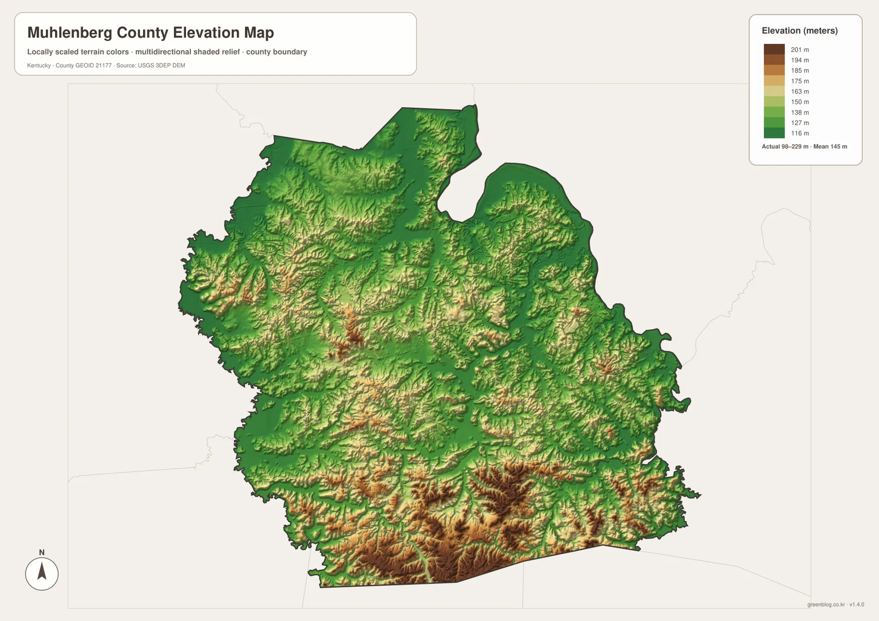
The official Muhlenberg County website and Kentucky.gov identify Greenville as the county seat and describe the county as a landscape of hills and valleys in western Kentucky’s coal field. That description matches the supplied maps closely. The northern river country is comparatively low, while the south and southeast contain stronger ridge relief. The elevation surface reports an actual range of about 98 to 229 meters with a mean near 145 meters.
Table of Contents
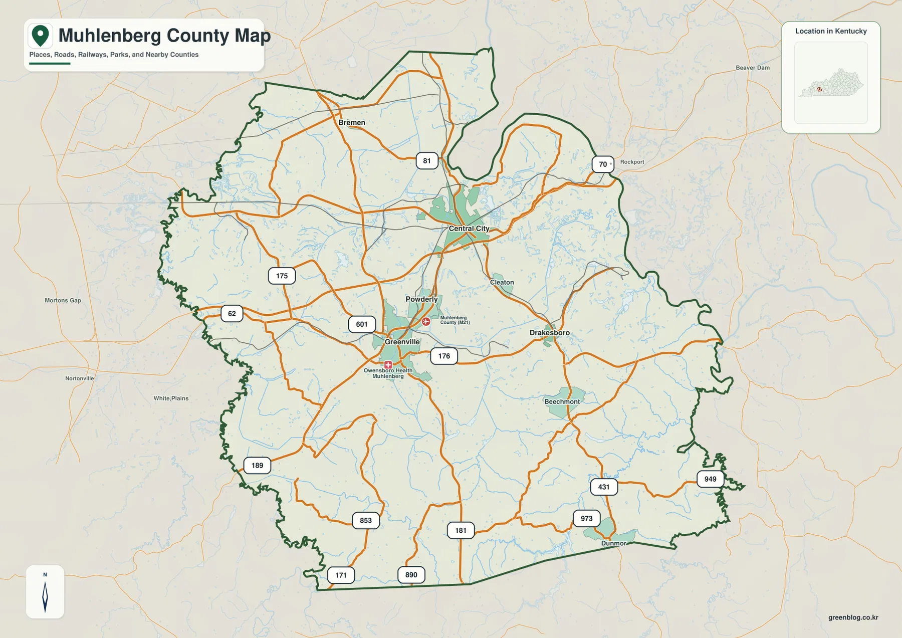
Greenville and Central City organize the main road network
The general county map makes Greenville and Central City the best starting points. Greenville sits near routes 62, 601, and 176, while Central City is tied to routes 81 and 70. Powderly lies between the two centers, giving the central part of the county a continuous developed corridor. Cleaton and Drakesboro extend that orientation eastward.
Bremen lies farther north near route 81, while route 175 crosses the western interior. Routes 189 and 853 provide southwestern references, and routes 181, 171, and 890 serve the southern part of the county. Around Dunmor in the southeast, routes 431, 973, and 949 help define the local road pattern near the county edge.
Beechmont provides another southeastern place reference, while Beaver Dam, Rockport, Nortonville, and White Plains appear outside the county to help with regional orientation. The road density is strongest around Greenville, Powderly, and Central City, then becomes more rural toward the western and southern edges.
This map is intended for geographic orientation rather than live navigation. It does not show current construction, closures, bridge restrictions, or travel times. Around the Pond River system and the more strongly rolling southern terrain, actual driving routes can be longer than the direct separation between two locations.
Central City and Greenville lead a six-city distribution
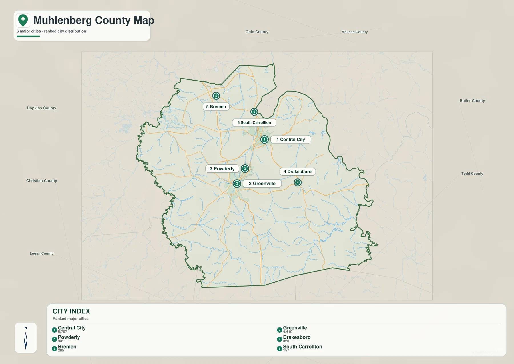
The city-distribution map ranks six major cities. Central City is listed first with 5,707 residents, Greenville second with 4,410, Powderly third with 931, Drakesboro fourth with 320, Bremen fifth with 285, and South Carrollton sixth with 157. Those values are the figures printed on the supplied map and are most useful for comparing the relative scale of the mapped settlements.
Central City and Greenville are close together in the north-central part of the county, with Powderly between them. Drakesboro lies east of that corridor, Bremen marks the northern section, and South Carrollton is positioned just north of Central City. The distribution shows that the county’s population centers are concentrated in a relatively compact northern-central area rather than spread evenly across the full county.
Neighboring county labels include Ohio, McLean, Butler, Todd, Christian, Logan, and Hopkins counties. Those references place Muhlenberg County within western Kentucky between the Green River system to the northeast and the Pond River drainage to the west. The simplified city view is useful when settlement size and direction matter more than local road detail.
Smaller place names still matter even when they are not included in the ranked city index. Beechmont, Cleaton, and Dunmor appear on the general map and help orient the southern and eastern sections. Using both maps together makes the distinction between the central urban corridor and the wider rural county much easier to see.
Green River, Pond River, and several lakes define the county’s water geography
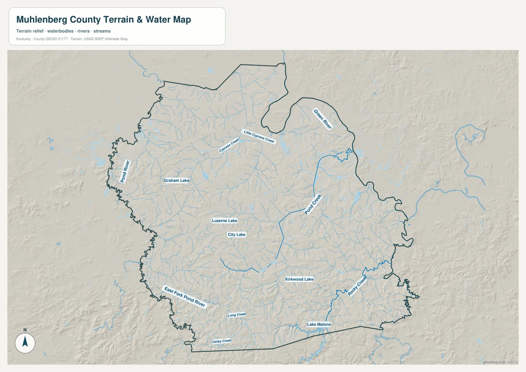
The Green River is the strongest water reference in the northeast, while the Pond River system occupies the western side and extends into the interior. Little Cypress Creek and Cypress Creek cross the northern half between those larger river systems. Their valleys are easy to follow because the shaded relief and water lines reinforce the same low corridors.
Graham Lake lies in the west-central area, while Luzerne Lake and City Lake sit closer to the middle of the county. Kirkwood Lake appears farther southeast, and Lake Malone forms the most prominent named lake near the southern boundary. Rocky Creek approaches that southeastern lake country through a winding valley.
East Fork Pond River runs near the southwestern edge, with Long Creek and Caney Creek dividing the southern interior. Many smaller unnamed tributaries fill the spaces between those labeled features, showing that Muhlenberg County is not simply flat lowland. The southern half contains a dense mix of creek bottoms and rolling ridges.
A practical reading order is to locate the Green River and Pond River first, then add the Cypress Creek system, the central lakes, and finally Lake Malone and Rocky Creek in the south. This is a geographic reference map rather than a flood, boating, water-depth, fishing-regulation, or property-access product. Current conditions should be checked with the responsible agencies.
Elevation from 98 to 229 meters rises toward the southern ridges
The elevation map reports an actual county range of about 98 to 229 meters and a mean near 145 meters. Lower green terrain is widespread across the north and follows the Green River, Pond River, and many tributary valleys. Higher yellow, orange, and brown relief becomes much more common in the south and southeast.
Around Bremen and Central City, broad areas remain in the lower green range, although short ridges still interrupt the lowland. Cypress Creek and Little Cypress Creek occupy additional low corridors. Those gentler northern elevations contrast with the more strongly rolling terrain south of Greenville and Powderly.
Near Dunmor, Lake Malone, and the south-central interior, the ridge pattern becomes much more pronounced. Long Creek, Caney Creek, and Rocky Creek remain in lower valleys while adjacent ridges rise into the darker elevation colors. The close spacing between creek bottoms and higher ground helps explain the winding road pattern in the southern county.
The elevation surface is designed for county-scale comparison rather than parcel-level measurement. It is useful for distinguishing river lowlands, creek valleys, and higher ridges, but it should not be treated as survey-grade elevation for a road, structure, property, or engineering project. Exact site work should rely on current source data or professional surveying.
Following the county from Greenville and Central City to Lake Malone
Greenville and Central City provide the easiest starting points for comparing the map views. On the road map, locate routes 62, 81, 70, and 176, then identify Powderly between the two cities. On the water map, the Green River to the northeast and Pond River to the west provide the larger physical framework around the central settlement corridor.
For the north, use Bremen and route 81 before locating Cypress Creek and Little Cypress Creek. The city-distribution map also shows Bremen and South Carrollton in relation to Central City. The elevation map confirms that this part of the county is generally lower and gentler than the southern interior.
For the south, use Dunmor with routes 181, 431, and 973 before locating Lake Malone, Rocky Creek, and Long Creek. The elevation surface shows some of the county’s strongest ridge relief in the same area. Comparing those features across the road, water, and elevation maps makes the southern landscape much easier to understand.
Choosing the best Muhlenberg County map for print, class, or reference
Use the general county map when Greenville, Central City, Powderly, Drakesboro, Bremen, numbered roads, and the full boundary need to appear together. The city-distribution map is cleaner when the main question is how the six ranked cities compare in location and relative size.
Choose the terrain-and-water map for the Green River, Pond River, Lake Malone, Graham Lake, City Lake, Cypress Creek, and southern tributaries. The elevation map is the strongest view for explaining the transition from lower northern river country to higher southern ridges. Comparing water and elevation together makes that relationship especially clear.
The WebP images in the article are optimized for browser viewing. The downloadable ZIP contains the original JPG maps at 3,638×2,572 pixels each, which is better suited to printing, classroom worksheets, presentations, and offline reference. These maps are general geographic resources rather than legal boundary records, flood studies, parcel surveys, navigation products, or engineering plans.
Frequently Asked Questions
Is Greenville or Central City the county seat?
Greenville is the county seat. Both the official Muhlenberg County website and Kentucky.gov identify Greenville as the administrative center. Central City is the largest city marker on the supplied city-distribution map, so the largest mapped city and the county seat are different places.
Which map best shows the Green River, Pond River, and Lake Malone together?
The terrain-and-water map is the best choice. It shows the Green River in the northeast, the Pond River system to the west, Little Cypress Creek, Cypress Creek, Graham Lake, Luzerne Lake, City Lake, Kirkwood Lake, Lake Malone, and several southern tributaries.
Can the 98–229 meter elevation range be used as an exact property elevation?
No. The range summarizes the actual countywide elevations shown on the supplied map, with a mean near 145 meters. It is useful for comparing river lowlands with higher ridges, but exact site elevations should come from current source data or professional surveying.
Map File Information
The ZIP archive contains the original high-resolution JPG versions of the Muhlenberg County road-and-boundary map, city-distribution map, terrain-and-water map, and elevation map. Each image is 3,638×2,572 pixels for printing, classroom work, presentations, and offline reference.
- File Type: 4 JPG files inside one ZIP archive
Related Maps
Sources and references
County information is available from the official Muhlenberg County website and the Kentucky.gov Muhlenberg County profile. For underlying geographic data, see the U.S. Census Bureau TIGER/Line Shapefiles for boundaries and roads, USGS National Hydrography for rivers, lakes, and streams, and the USGS 3D Elevation Program for elevation data.
These maps are intended for geographic explanation, printing, and general reference. Legal boundary decisions, live traffic, flood and water-safety questions, property surveying, and engineering work should rely on the latest authoritative information from the responsible public agency.
Green Map creates custom-edited map images using open geographic data sources such as geoBoundaries, Natural Earth, OpenStreetMap, and government open data. These maps are edited visual materials, not raw data files, and are provided for education, documents, presentations, and graphic reference.