Meade County occupies a distinctive stretch of northern Kentucky where the Ohio River bends repeatedly along the county’s northern edge and Brandenburg sits close to the river as the clearest local hub. Muldraugh marks the eastern side near US 31W and Fort Knox, Ekron provides a south-central reference, and Doe Valley lies between Brandenburg and the eastern boundary. The general map shows routes 144, 376, 477, 79, 60, 933, 448, 31W, 313, and 333, while the physical maps reveal Wolf Creek, Spring Creek, Doe Run, Otter Creek, Doe Valley Lake, and strong relief away from the river. High-resolution JPG versions of the supplied maps can also be downloaded together in one ZIP archive for printing, classroom work, presentations, or offline reference. High-resolution map files are available for download in the section below.
Brandenburg’s official city website highlights its Riverfront Park and Ohio River setting, which matches the map’s strongest geographic feature. The city lies where the river corridor and several road connections meet. Muldraugh sits at the eastern edge beside Fort Knox, while Ekron is farther south in the county interior. The elevation map reports an actual range of about 117 to 307 meters, showing a sharp contrast between the green river lowlands and the higher ridges of the northwest and south-central county.
Table of Contents
Roads spread from Brandenburg toward Muldraugh, Ekron, and the county interior
Brandenburg is the most useful starting point on the general county map. Routes 144 and 376 connect the city with western and northwestern sections, while routes 79 and 60 serve the broader interior. East of Brandenburg, route 933 appears near Doe Valley, and route 448 continues south toward Ekron and the Muldraugh side. The road system follows a rolling landscape rather than a rigid grid, so many routes bend between stream valleys and higher ridges.
Muldraugh lies close to the eastern county boundary along US 31W, with route 313 continuing south beside the Fort Knox area. West Point, Radcliff, and Vine Grove appear outside the boundary as useful orientation labels. The Fort Knox edge is clearly visible on the map, making eastern Meade County look very different from the river-focused Brandenburg area.
Ekron sits southeast of Brandenburg near route 448, with routes 60, 333, and 313 helping organize the larger southern interior. Routes 477 and 144 are important farther west, while Irvington and Cloverport appear outside the county as regional references. The west and northwest are more strongly cut by tributary valleys, whereas the central-southern road network contains several longer stretches between settlements.
This general map is best for seeing settlements, numbered roads, county boundaries, and the Fort Knox edge together. It is not a live navigation product, so current construction, bridge conditions, temporary closures, and travel times should be checked with current transportation sources. River bends and creek valleys can make actual road travel longer than the direct separation between points.
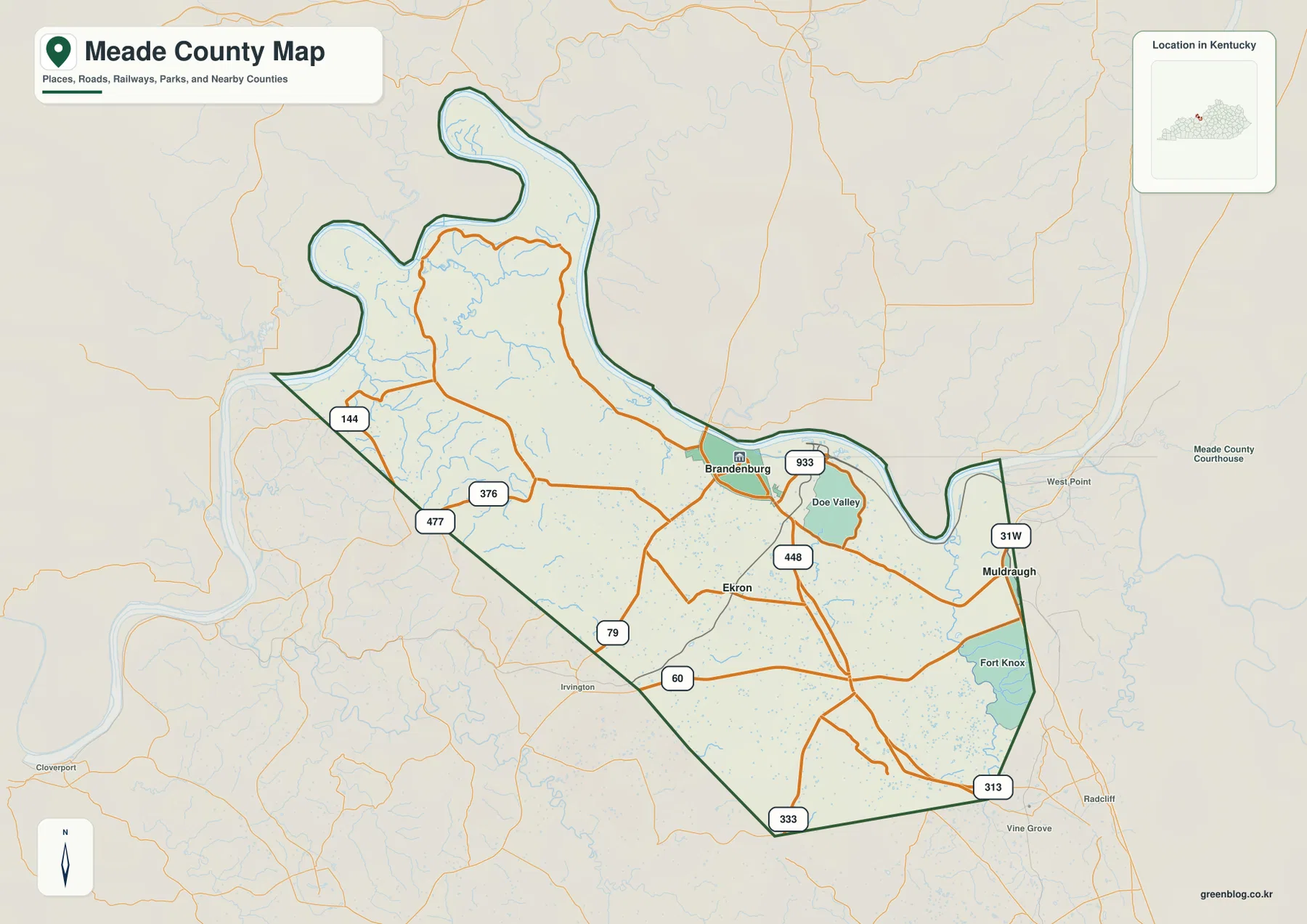
Straight-line connections place Muldraugh 11 miles and Ekron 4 miles from Brandenburg
The city-connections map uses Brandenburg as the hub and highlights Muldraugh and Ekron. The supplied map labels Brandenburg with 2,937 residents, Muldraugh with 1,127, and Ekron with 130. It lists a direct distance of about 11 miles from Brandenburg to Muldraugh and about 4 miles from Brandenburg to Ekron. These are straight-line distances between mapped points rather than driving distances along the road network.
Muldraugh lies east of Brandenburg close to US 31W, Fort Knox, and the Otter Creek side of the county. Ekron is southeast and much closer in direct distance. The routes nevertheless pass through different settings: travel toward Muldraugh approaches the eastern river bends, military boundary, and creek valleys, while the Ekron side crosses the rolling county interior.
Doe Valley is not shown as a ranked major city on the connections map, but it is prominent on the general map between Brandenburg and Muldraugh. Doe Valley Lake is also clearly labeled on the water map. Those features make Doe Valley a practical secondary reference when moving between the city, road, water, and elevation views.
The simplified city map works well when direction and spacing matter more than detailed routes. The general map is the better choice for actual road relationships, Fort Knox context, and Doe Valley. Keeping Brandenburg as the shared reference point makes it easy to compare the views without losing orientation.
Ohio River bends connect Wolf Creek, Doe Run, and the Otter Creek valley
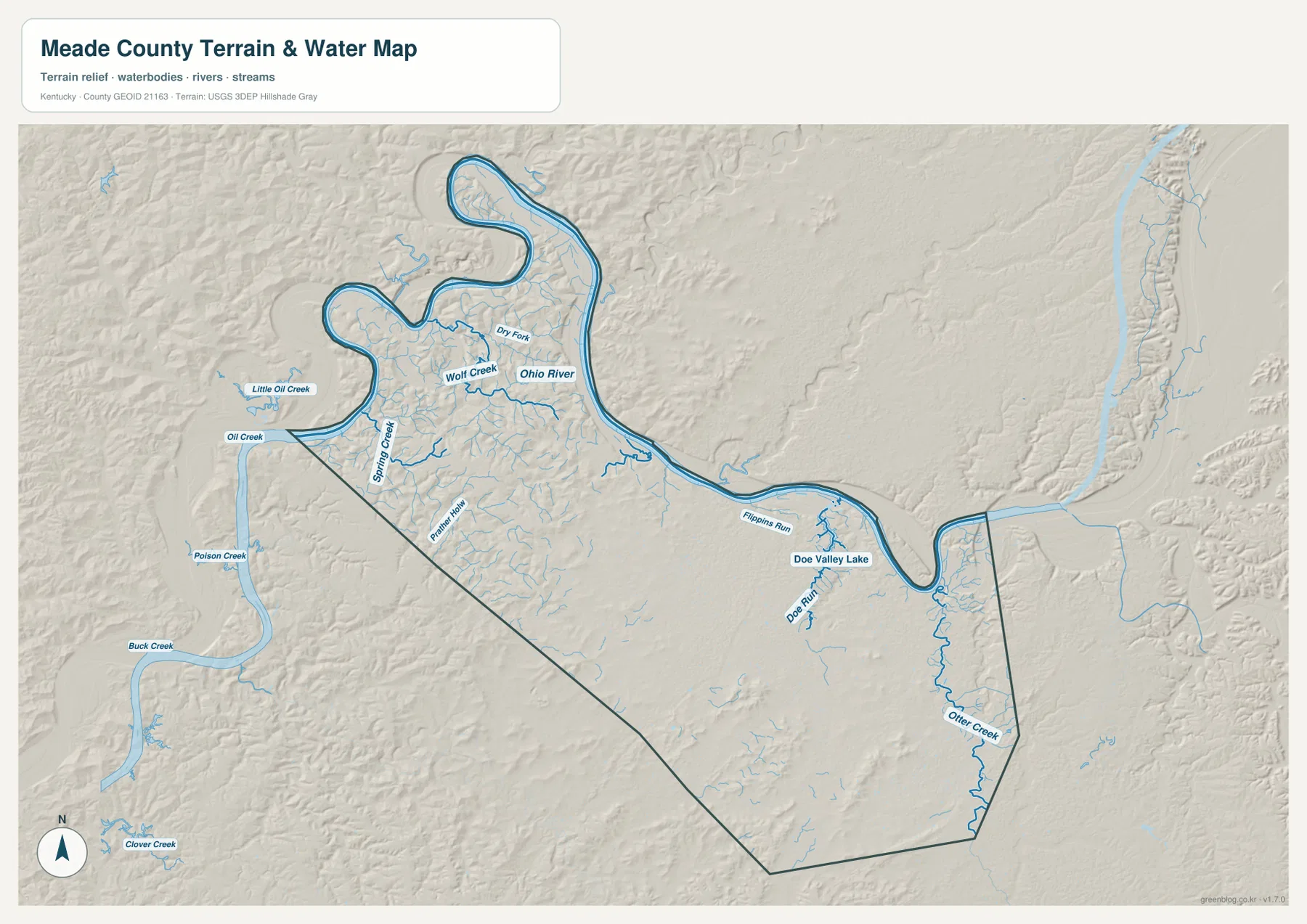
The terrain-and-water map is dominated by the Ohio River, which loops around the northern and northeastern boundary in a series of broad bends. Wolf Creek and Dry Fork occupy valleys just inland from the river near the Brandenburg side. In the northwest, Oil Creek and Little Oil Creek approach the Ohio, while Spring Creek cuts a longer valley through the hill country.
Moving east from Brandenburg, Flippins Run reaches toward the Ohio River, and Doe Valley is marked by Doe Run and Doe Valley Lake. The lake is small compared with the river but is one of the clearest inland water landmarks on the map. Those eastern tributaries also correspond to lower green corridors on the elevation map.
Otter Creek is the strongest named waterway on the southeastern side. It follows a narrow valley near Muldraugh and the Fort Knox edge before continuing toward the larger river system. The official Kentucky Department of Fish and Wildlife page for Otter Creek Outdoor Recreation Area identifies the area with Meade County and the Ohio River landscape, making it a useful current source for recreation and access information.
A practical way to read the water map is to begin with the Ohio River, then move through Oil Creek and Spring Creek in the northwest, Wolf Creek near the northern interior, Doe Run and Doe Valley Lake in the east, and finally Otter Creek in the southeast. This is a geographic reference map rather than a flood, navigation, water-depth, fishing-regulation, or property-access product. Current conditions should come from the responsible agencies.
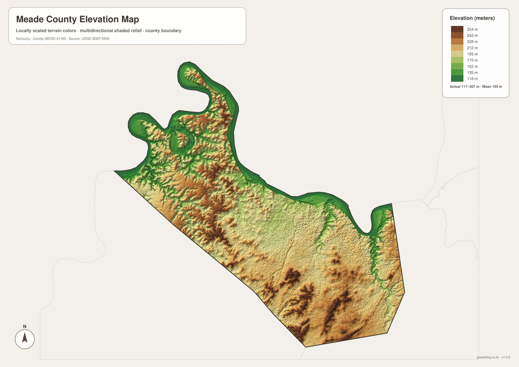
Elevation from 117 to 307 meters rises quickly away from the river
The elevation map reports an actual county range of about 117 to 307 meters and a mean near 195 meters. The lowest dark-green terrain follows the Ohio River along the northern and northeastern boundary, with additional low corridors along Otter Creek and other tributaries. Higher orange and brown ridges are densely packed in the northwest and western interior, and several pronounced uplands also stand out in the south-central part of the county.
The northwestern river bends show some of the sharpest local relief. Low ground lies directly beside the Ohio River, but elevation increases quickly around Wolf Creek and Spring Creek. Routes 144, 376, and 477 pass through this broken terrain, so the elevation view adds useful context to the winding road pattern on the general map.
East of Brandenburg, the Doe Valley area contains broader rolling terrain, although Doe Run and Otter Creek remain as distinct low valleys. Near Muldraugh and the Fort Knox edge, the Otter Creek corridor is bordered by higher ground on both sides. The southeast therefore combines a narrow drainage valley with a much more elevated surrounding landscape.
The colored elevation surface is designed for county-scale comparison rather than parcel-level measurement. It is useful for distinguishing river lowlands, stream valleys, and higher ridges, but it should not be treated as survey-grade elevation for a building, road, property, or engineering project. Exact site work should rely on current source elevation data or professional surveying.
Following Meade County from Brandenburg to Doe Valley and Otter Creek
Brandenburg is the easiest place to begin comparing the map views. On the general map, locate routes 144, 376, and 933 beside the Ohio River. Then move to the water map and find the river bends and Wolf Creek. From there, follow the eastern road network toward Doe Valley and compare Doe Run and Doe Valley Lake with the lower green terrain on the elevation map.
Muldraugh provides a useful eastern reference. US 31W and route 313 establish the road location, while the Fort Knox edge is immediately nearby. On the physical maps, Otter Creek becomes the main valley reference. Its low corridor explains much of the local terrain and shows why the eastern county cannot be understood from road lines alone.
Ekron is a good starting point for the south-central interior. Route 448 connects it with the Brandenburg side, while routes 60, 333, and 313 extend across broader parts of the southern county. The elevation map shows a mixture of rolling terrain and isolated higher ridges in this area, creating a clear contrast with the flat river margin to the north.
Choosing the best Meade County map for print, class, or local reference
Use the general county map when Brandenburg, Muldraugh, Ekron, Doe Valley, numbered roads, county boundaries, and the Fort Knox edge need to appear together. The city-connections map is cleaner when the main question is how Muldraugh and Ekron relate to Brandenburg and what their straight-line distances are.
Choose the terrain-and-water map for the Ohio River, Wolf Creek, Spring Creek, Doe Run, Doe Valley Lake, and Otter Creek. The elevation map is the strongest view for explaining the transition from low river ground to the higher northwest and south-central ridges. Showing water and elevation together makes the connection between low valleys and uplands especially clear.
The WebP images in the article are optimized for browser viewing. The downloadable ZIP contains the original JPG maps at 3,638×2,572 pixels each, which is better suited to printing, classroom worksheets, presentations, and offline reference. These maps are general geographic resources rather than legal boundary records, flood studies, navigation charts, parcel surveys, military-access maps, or engineering plans.
Frequently Asked Questions
Are the Brandenburg-to-Muldraugh and Brandenburg-to-Ekron distances driving distances?
No. The city-connections map shows straight-line distances of about 11 miles to Muldraugh and 4 miles to Ekron. Actual driving distances can be longer because roads follow river bends, creek valleys, intersections, and the Fort Knox-side road network rather than the direct line between points.
Which map best shows the Ohio River and Otter Creek together?
The terrain-and-water map is the best choice. It shows the Ohio River along the northern boundary together with Oil Creek, Spring Creek, Wolf Creek, Doe Run, Doe Valley Lake, and Otter Creek. It is especially useful for comparing the river-side lowlands with the narrow southeastern creek valley.
Can the 117–307 meter elevation range be used as an exact property elevation?
No. The range summarizes the actual countywide elevations shown on the supplied map, with a mean near 195 meters. It is useful for comparing low Ohio River ground with higher ridges, but exact site elevations should come from current source data or professional surveying.
Map File Information
The ZIP archive contains the original high-resolution JPG versions of the Meade County road-and-boundary map, city-connections map, terrain-and-water map, and elevation map. Each image is 3,638×2,572 pixels for printing, classroom work, presentations, and offline reference.
- File Type: 4 JPG files inside one ZIP archive
Related Maps
Sources and references
County information is available from the official Meade County government website and Kentucky.gov local government directory. For Brandenburg and the Ohio River setting, see the official City of Brandenburg website. Current information about the local recreation area is available from the Kentucky Department of Fish & Wildlife Otter Creek Outdoor Recreation Area page. For underlying geographic data, see the U.S. Census Bureau TIGER/Line Shapefiles, USGS National Hydrography, and the USGS 3D Elevation Program.
These maps are intended for geographic explanation, printing, and general reference. Legal boundary decisions, live traffic, flood and water-safety questions, military-access restrictions, property surveying, and engineering work should rely on the latest authoritative information from the responsible public agency.
Green Map creates custom-edited map images using open geographic data sources such as geoBoundaries, Natural Earth, OpenStreetMap, and government open data. These maps are edited visual materials, not raw data files, and are provided for education, documents, presentations, and graphic reference.