Leslie County sits in the rugged mountains of eastern Kentucky, where the county seat of Hyden occupies one of the lower corridors between densely packed ridges. The maps on this page separate that complicated landscape into useful views: a county-and-roads map, a simplified city map, a terrain-and-water map, and an elevation map. Together they show why roads bend through long valleys, why many creek names matter for orientation, and why the southern half of the county feels much larger on the ground than a straight-line glance might suggest. High-resolution JPG versions of all four maps are available in the download box below.
The Leslie County government describes the county as part of Kentucky’s Eastern Coal Field and notes that it was formed in 1878 from portions of Clay, Harlan, and Perry counties. Hyden is the county seat, but the boundary stretches far beyond the town, especially to the south. That shape is important when reading the maps. Leslie County is not organized around a broad flat center; instead, narrow creek valleys repeatedly divide steep ridge country, and the transportation network follows those lower passages whenever possible.
Table of Contents
Start at Hyden, then follow the numbered roads into separate valleys
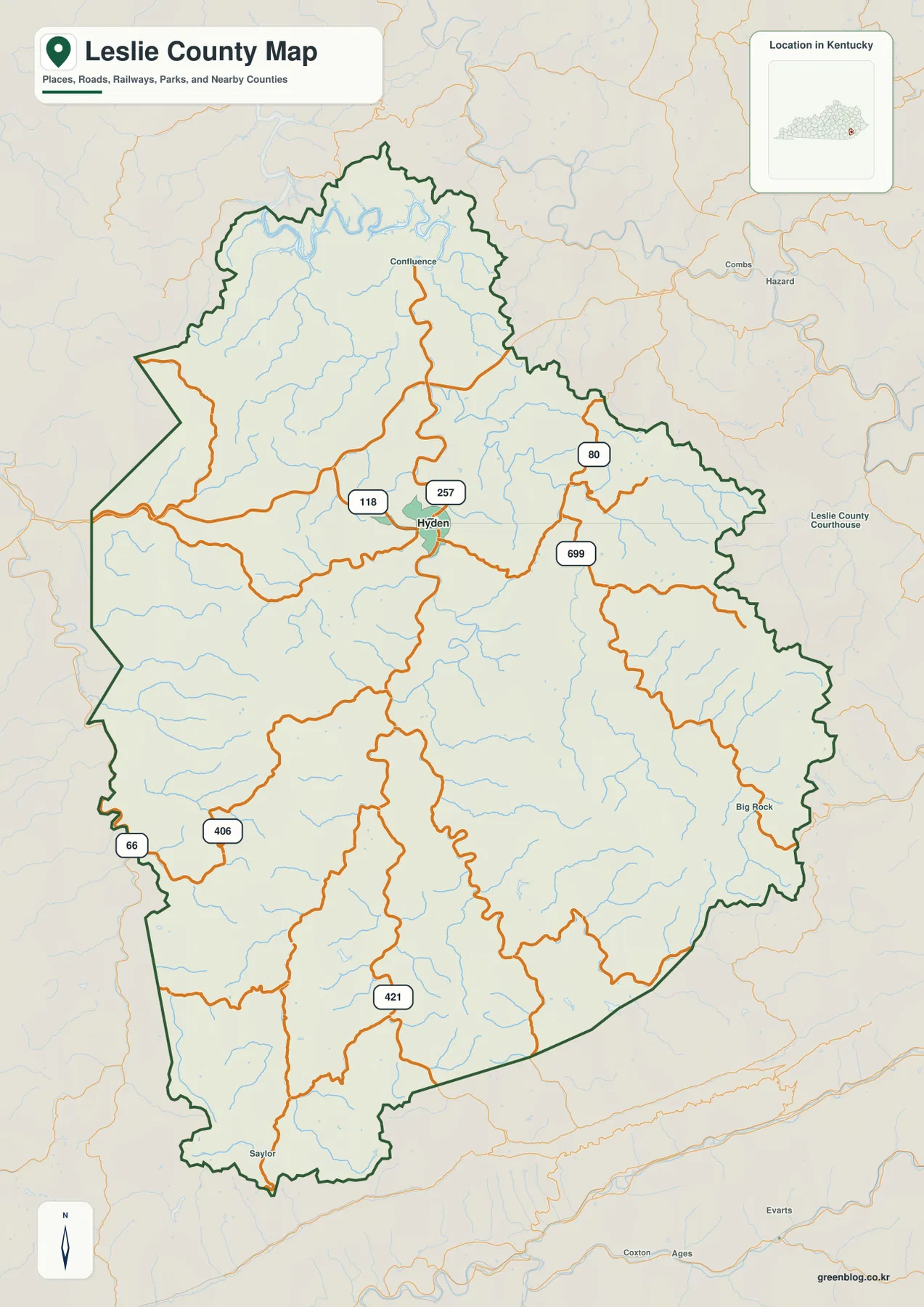
Hyden is the easiest reference point on the county map because several numbered routes meet close to town. Kentucky Routes 118 and 257 approach from the west and northwest, while Routes 80 and 699 extend into valleys to the east. U.S. 421 provides the most obvious long corridor into the southern half of Leslie County. Routes 66 and 406 appear farther west and southwest. The result is a road pattern that looks irregular compared with a grid, but it makes sense once the surrounding ridges and creek valleys are considered.
Three smaller labels are especially useful for understanding the county’s length. Confluence lies north of Hyden, Big Rock provides a reference toward the eastern and southeastern side, and Saylor sits close to the narrow southern end. Finding those names before studying the smaller roads helps the outline feel less abstract. Hyden does not sit in the center of an evenly shaped area; it is a practical hub in the northern half of a long mountain county, with separate valleys continuing well beyond it.
The county map works best as an orientation map rather than a legal or navigation document. It can show how U.S. 421 relates to Hyden, where Route 80 heads east, or which side of the county contains Big Rock, but it cannot tell you current road conditions, parcel ownership, voting districts, or exact jurisdiction along a roadway. For travel planning, use current transportation information alongside this static map. For a classroom, local-history project, or general geographic reference, however, the combination of boundary, places, and major roads gives a clear first picture of Leslie County.
A single city marker makes the county seat easy to place
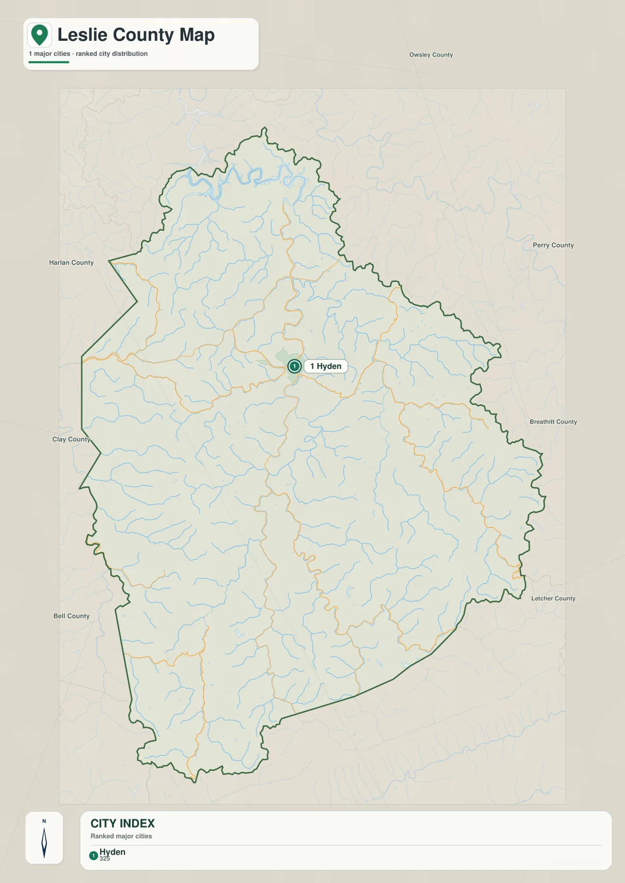
The city map intentionally removes much of the detail and emphasizes Hyden as the principal city marker. That makes it useful when the first question is simply where the county seat lies inside the boundary. Hyden is north of the county’s midpoint, while a large part of Leslie County continues south toward the long lower boundary. The simplified view is especially effective in presentations or lessons where a dense road map would make the basic location harder to see.
The surrounding county labels add regional context. Owsley County is shown to the north, Perry County to the northeast, Breathitt County to the east, and Letcher County to the southeast. Clay, Harlan, and Bell counties appear along the western and southwestern sides. Those neighboring names help place Leslie County within the broader eastern Kentucky mountain region without requiring a separate state map.
The one-city index should not be treated as a complete inventory of communities. The more detailed county map includes names such as Confluence, Big Rock, and Saylor, while the water map introduces creek names that often correspond more closely to the narrow valleys people use for local orientation. The city map is therefore a clean location tool, not a statement that nothing exists outside Hyden. Its value comes from giving the reader a simple anchor before moving to the more detailed road, water, and elevation views.
The Middle Fork and named creeks give the valleys their clearest identities
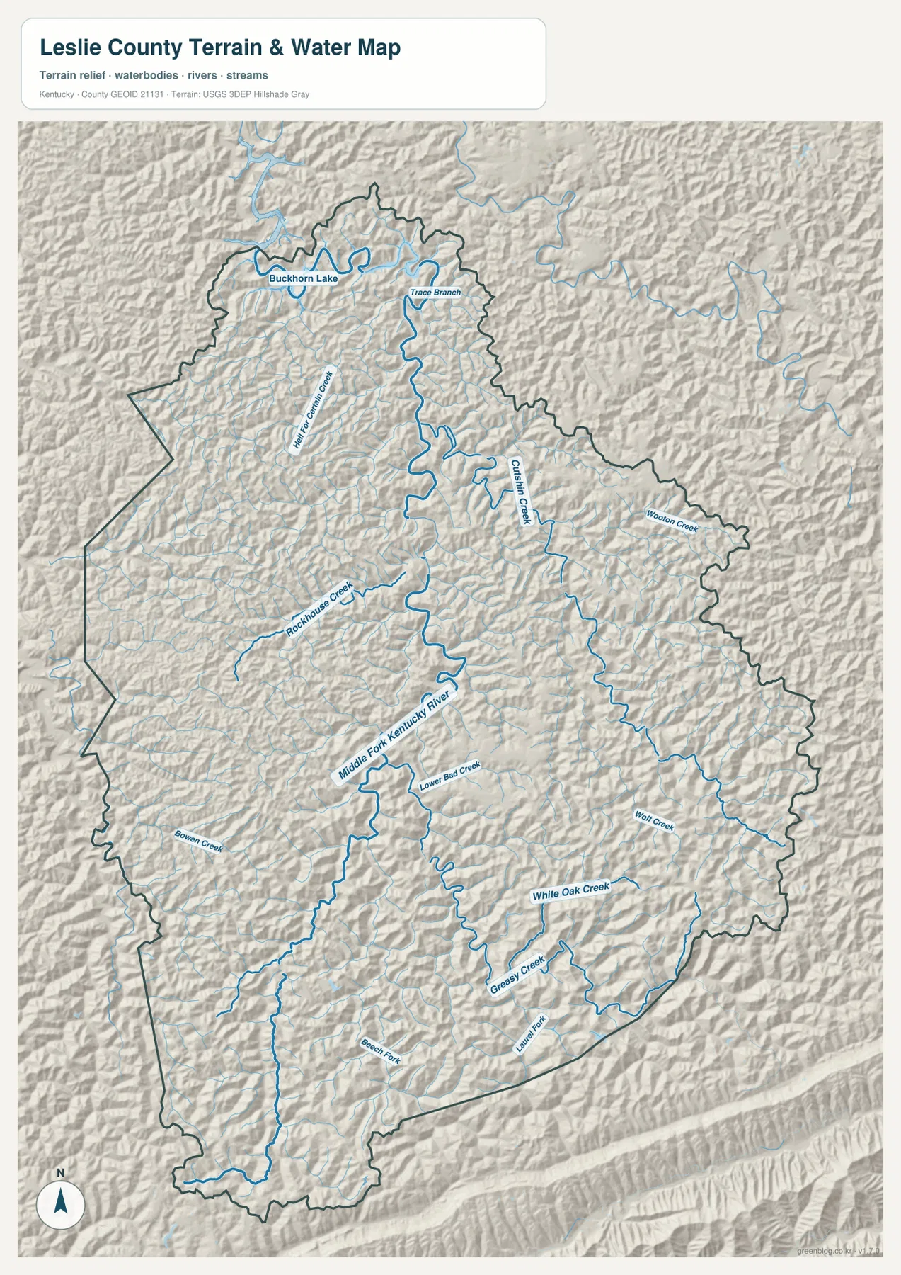
The terrain-and-water map reveals the county as a network of stream valleys. Middle Fork Kentucky River is the strongest named channel through the interior, and smaller streams join it from several directions. Trace Branch appears in the northern section, Cutshin Creek follows a long eastern valley, Rockhouse Creek enters from the west, and Hell for Certain Creek is labeled farther to the northwest. Wooton Creek provides another useful eastern reference. These names turn what might otherwise look like repeated mountain folds into identifiable local corridors.
The southern half contains another group of named streams. Wolf Creek and White Oak Creek are prominent in the southeast, Greasy Creek and Laurel Fork appear farther south, and Bowen Creek and Beech Fork are labeled toward the western side. None of these waterways needs to be large to matter on a mountain map. A relatively small creek can occupy the lowest continuous passage between steep ridges, and roads or small communities often share that same corridor.
Hyden becomes easier to understand when the road and water maps are read together. Leslie County’s official history describes the town as developing at the mouth of Rockhouse Creek on the Middle Fork of the Kentucky River. On the supplied maps, several road approaches and stream valleys come together in the same general area. The relationship is straightforward: in steep country, valleys offer more workable ground than ridge tops, so settlement and transportation tend to concentrate where those lower passages meet.
Buckhorn Lake is labeled near the northern edge of the terrain map as part of the wider watershed context. The label should not be read as proof that the entire reservoir lies within Leslie County. The same caution applies to the blue stream lines: they are not flood zones, property boundaries, navigability designations, or public-access guarantees. Questions about flood risk require current FEMA or local emergency-management information, while property and legal boundary questions require county land records and survey sources.
Elevation explains why nearby places can require long road detours
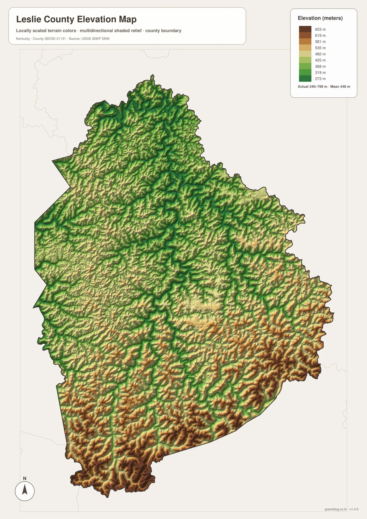
The elevation map shows an actual range of roughly 240 to 789 meters, with a mean near 448 meters. Greens represent relatively low terrain, while yellow, tan, and brown mark higher ground. The county does not rise in one simple direction. Instead, narrow green corridors wind between repeated ridges, creating a pattern in which elevation changes sharply over short horizontal distances. That is the terrain behind the winding road network visible on the county map.
Higher colors become especially widespread in the south and southeast, where connected ridges form some of the most rugged-looking parts of the map. Elevated ground also appears across the eastern interior. By contrast, lower green terrain follows the Middle Fork and many of its tributaries, including the broader corridor around Hyden. The important comparison is not merely the highest number versus the lowest number; it is the repeated contrast between a low valley floor and the ridge immediately beside it.
The county government gives an elevation range of about 757 to 2,600 feet, which converts to approximately 231 to 792 meters. That is close to the range printed on the supplied elevation map, though different source dates and processing methods can create small differences. This map is well suited to county-wide comparison, but it is not a substitute for a site survey. Engineering, construction, drainage design, or property work should rely on detailed USGS data or professional measurements rather than a generalized county image.
Comparing the elevation map with the water map makes the road pattern much more intuitive. Creeks such as Cutshin, Wolf, and White Oak occupy low passages, while the spaces between them rise quickly into narrow ridges. Two points may look close in a straight line yet be separated by steep ground, forcing a road to follow a longer valley route. In Leslie County, the elevation layer is therefore more than background scenery; it helps explain where roads go, where settlements cluster, and why the county’s interior is divided into many small valley areas.
Use Confluence, Big Rock, and Saylor as checkpoints beyond Hyden
A map centered only on Hyden can make the outer parts of Leslie County difficult to remember. Confluence, Big Rock, and Saylor solve that problem by acting as simple checkpoints. Confluence marks the northern interior, Big Rock helps orient the eastern and southeastern projection, and Saylor identifies the long southern end. Once those names are familiar, it becomes easier to move between maps without losing track of which part of the county is being discussed.
The surrounding terrain gives each checkpoint a different setting. Near Confluence, the northern boundary bends around numerous small drainages. The Big Rock side is associated with eastern ridge-and-creek country connected with the Cutshin and Wooton areas. Toward Saylor, U.S. 421 continues through the extended southern section as higher colors become more common on the elevation map. These are map-reading reference points rather than claims about population size or administrative rank.
This method is particularly useful in a mountain county because simple compass directions are often too vague. “South of Hyden” covers a long distance and several separate valleys, while “toward Saylor on the U.S. 421 side” gives a more concrete mental picture. A reader studying a road trip, local history, or a school project can first locate Hyden and these three secondary places, then add the creek names or elevation features that matter for the specific topic.
Match the map to the question instead of forcing every detail onto one image
Use the county map when the priority is the boundary, named places, and major roads. It is the best choice for showing how Hyden connects with the rest of Leslie County or for locating Routes 80, 118, 257, 699, and U.S. 421 in one view. Use the city map when a cleaner presentation is more important and the main point is simply the position of Hyden and the surrounding counties.
Choose the terrain-and-water map when the subject is the Middle Fork Kentucky River, named creeks, or the relationship between stream valleys and ridge country. Choose the elevation map when the main question is where the county is lower or higher, especially the contrast between the Hyden/Middle Fork corridor and the southern or southeastern ridges. Separating these topics keeps labels readable and avoids the clutter that would result from placing roads, creek names, city markers, and elevation colors on a single image.
The downloadable package contains four A3 high-resolution JPG files. Those files are better suited to printing than the web previews and can be used for classroom material, presentations, local reference, or personal projects. They remain general-reference maps, however. Legal boundaries, property ownership, flood hazards, and real-time travel conditions require current purpose-built sources from the responsible agencies.
Frequently Asked Questions
Why do so many roads meet near Hyden instead of crossing the county in straight lines?
Hyden lies in lower valley terrain near the Middle Fork Kentucky River system, where several usable corridors come together. Routes 80, 118, 257, and 699 are labeled close to town, while U.S. 421 continues south through another long valley. The water and elevation maps show steep ridges surrounding these lower passages, so roads tend to follow valleys and change direction rather than cut straight across high ground.
Where does the elevation map show the highest-looking terrain in Leslie County?
The strongest tan and brown colors appear across much of the southern and southeastern part of the county, with additional high ridges in the eastern interior. The map’s stated range is about 240–789 meters, while lower green corridors follow the Middle Fork and several tributaries. The image is intended for regional comparison and should not be used as a precise elevation survey for a particular address.
Can the blue stream lines be used to determine flood risk or property boundaries?
No. The blue lines show the general location of the Middle Fork Kentucky River and named tributaries, not FEMA flood zones, parcel lines, or legal water boundaries. Use current FEMA and local emergency-management sources for flood questions, and county land records or professional surveys for ownership and boundary questions. The supplied water map is best used to understand how creeks and valleys fit within the county.
Map File Information
The ZIP contains A3 high-resolution JPG versions of the Leslie County boundary/road map, city map, terrain-and-water map, and elevation map.
- Included Files: Use only the versions confirmed in the article and supplied images
- File Type: Use the confirmed download contents
- Intended Use: Printing, education, presentations, and map-based projects
Related Maps
Sources and references
County formation, the role of Hyden as the county seat, and local background can be checked on the official Leslie County website and its About Us page. Current population and other basic statistics are available through U.S. Census Bureau QuickFacts.
Boundary and road source data can be obtained from U.S. Census Bureau TIGER/Line files. Hydrography is supported by USGS National Hydrography, and detailed elevation data are available through the USGS 3D Elevation Program. For legal, property, hazard, or engineering decisions, always use the latest official source designed for that purpose.
Green Map creates custom-edited map images using open geographic data sources such as geoBoundaries, Natural Earth, OpenStreetMap, and government open data. These maps are edited visual materials, not raw data files, and are provided for education, documents, presentations, and graphic reference.