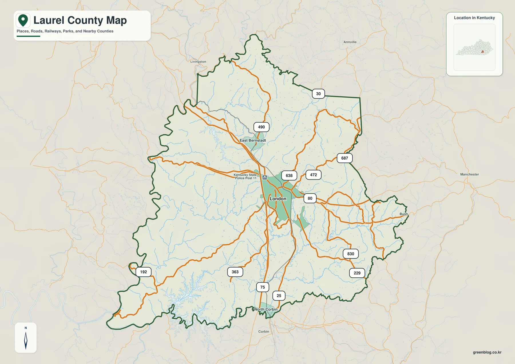
Laurel County sits in southeastern Kentucky, where London forms the main road and service center between broad ridges, narrow stream valleys, and reservoir country. I-75 passes through the middle of the county, East Bernstadt appears to the north, and North Corbin marks the southern edge. The western side follows the Rockcastle River corridor, while Laurel River Lake occupies a broad, branching basin in the southwest. High-resolution map files are available for download in the section below.
The web maps are convenient for quick viewing, and the original high-resolution JPG files can be downloaded from the box below when you need to enlarge small route numbers, stream names, or reservoir shorelines. Using the road, water, and elevation images together makes it easier to see why London has a relatively open central setting while many outlying roads follow valleys through steeper terrain.
Table of Contents
London and I-75 provide the clearest orientation through the county
On the general county map, London sits slightly south of center and has the densest collection of major roads. I-75 runs north–south through the city, while KY 80 crosses the county from west to east. Route 490 reaches north toward East Bernstadt, and Routes 638, 472, and 687 spread into the eastern hills. South of London, Routes 25, 75, and 229 lead toward North Corbin and the county line, while 192 and 363 head into the southwestern lake country.
East Bernstadt is the strongest place-name reference north of London, and North Corbin is the easiest southern marker. Together they show how Laurel County stretches along the I-75 corridor while side roads branch away into rougher terrain. The western boundary is irregular near Rockcastle County, and the eastern edge rises into the hill country toward Clay County, so road distance can be noticeably longer than a straight-line measurement suggests.
The road pattern becomes less dense away from London. If the destination is Laurel River Lake, it helps to follow the southwest routes and compare them with the reservoir shoreline. Trips into the eastern part of the county are easier to understand by matching KY 80 and Routes 472, 687, 830, and 229 with the valleys shown on the terrain map.
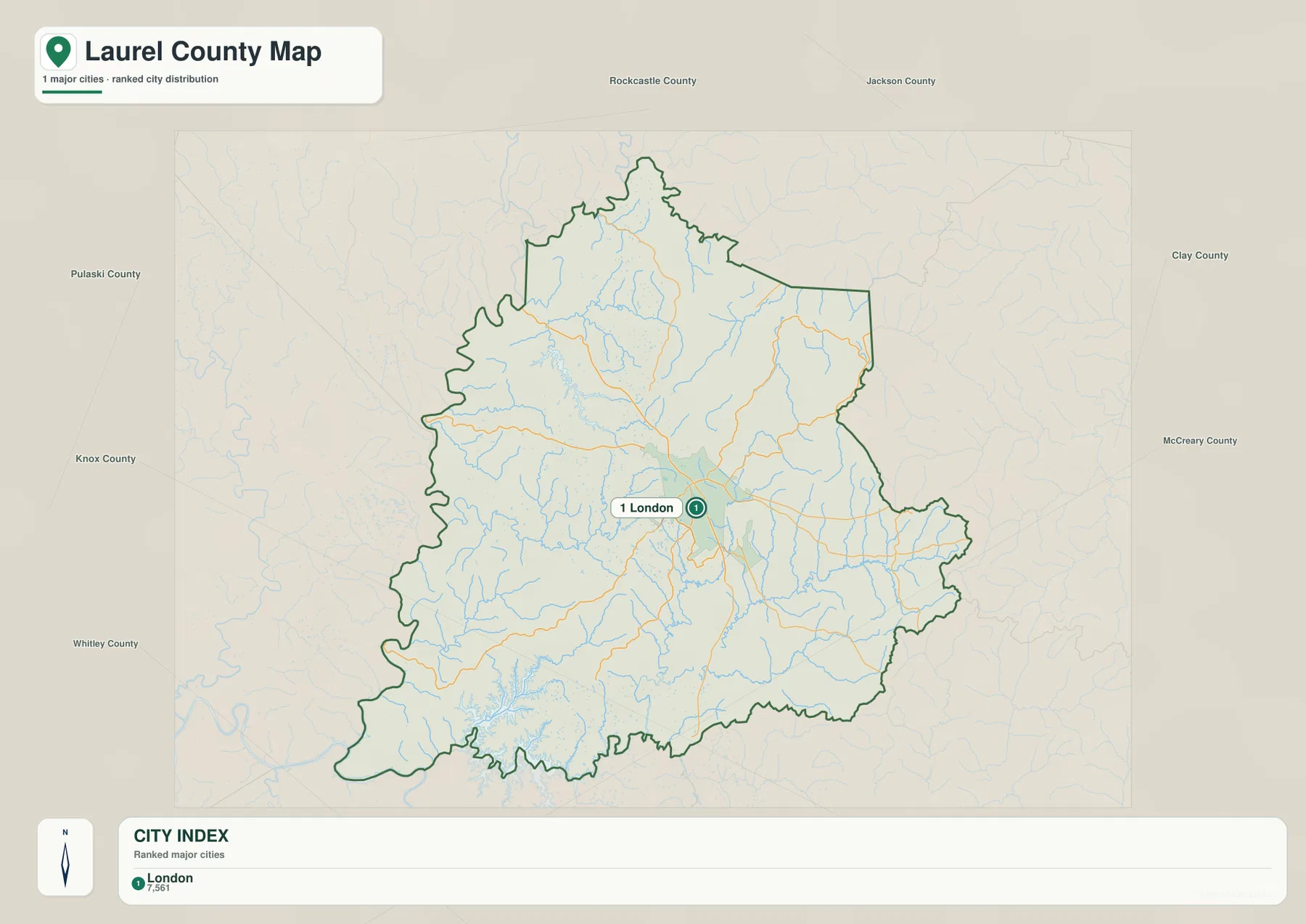
The city index emphasizes London as the single major city reference
The city map highlights London alone as the major city and prints a reference value of 7,561. That number is best treated as the value embedded in the supplied map rather than as a claim about the latest population estimate. Its main purpose here is to show that London is the dominant city reference for navigating the county.
Other named places still matter on the general map. East Bernstadt helps orient the northern section, while North Corbin marks the transition toward the Corbin area at the southern edge. Starting with the simplified city map and then switching to the full road map gives a clearer picture of how the county center relates to the more dispersed mountain communities.
Kentucky’s official county profile notes that Laurel County was organized in 1825 and was named for the Laurel River. Current London–Laurel County tourism material presents the area as a gateway to forest, lakes, rivers, and outdoor recreation. Those descriptions fit the geography visible here: a concentrated city center surrounded by a much broader landscape of ridges, reservoirs, and stream valleys.
Laurel River Lake and Rockcastle River define two of the strongest water features
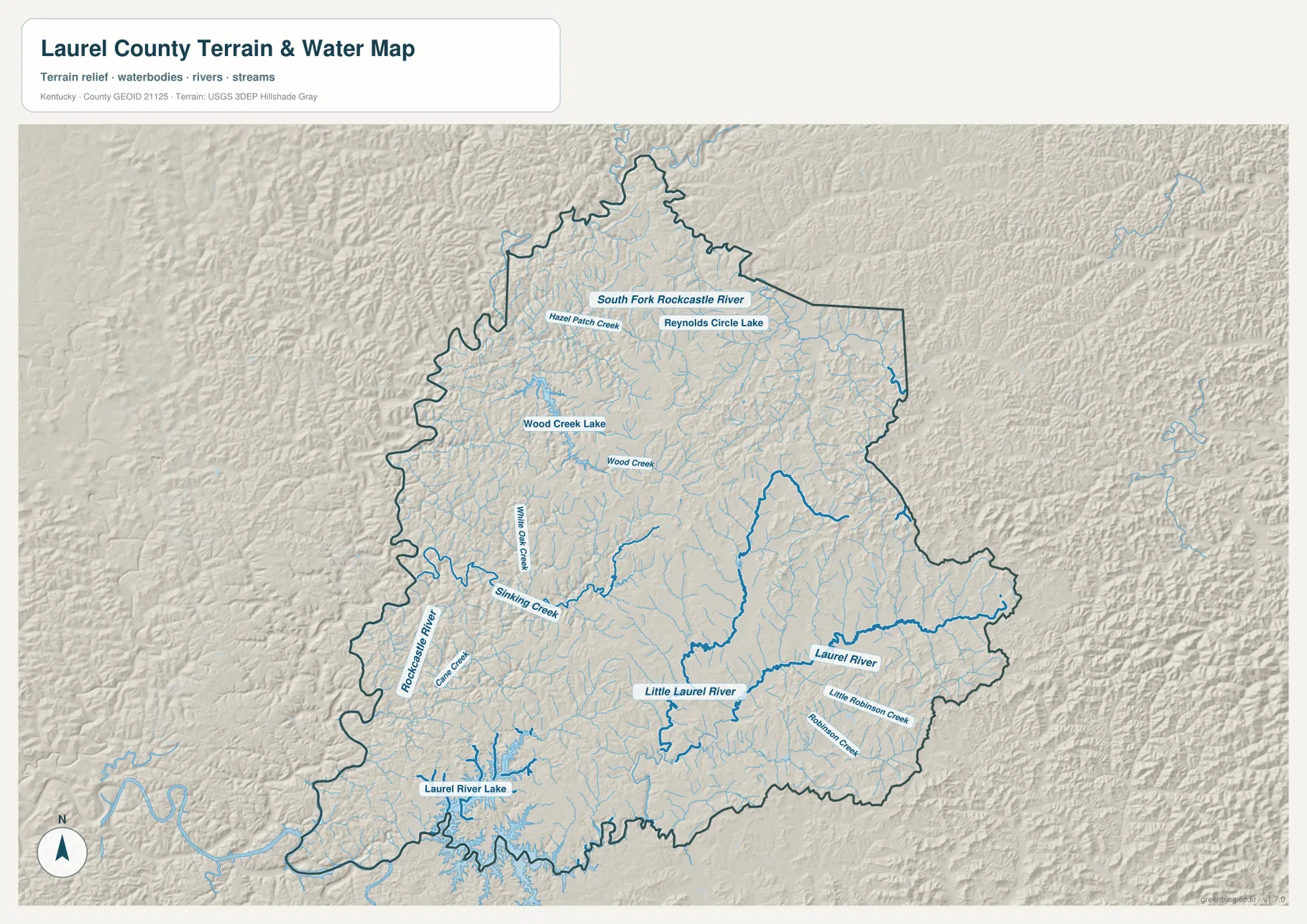
Laurel River Lake is the largest and most visually distinctive waterbody on the terrain-and-water map. Little Laurel River enters the reservoir from the north, while Laurel River and the Robinson Creek system occupy the eastern and southeastern side. The shoreline branches deeply into surrounding valleys, giving the lake a complex shape that reflects the rugged terrain around it.
Along the western edge, Rockcastle River forms a long boundary-side corridor. Cane Creek, Sinking Creek, and Wild Dog Creek drain toward lower terrain in that direction. The northwest contains Wood Creek and Wood Creek Lake, while farther north the map labels South Fork Rockcastle River, Hazel Patch Creek, and Reynolds Circle Lake. These waterways make the county’s network of valleys especially easy to see.
Kentucky Tourism describes Laurel River Lake as a 5,600-acre lake in Laurel and Whitley counties within the Daniel Boone National Forest area. This county-scale image is useful for geographic context, but it is not a substitute for live water levels, flood mapping, boating navigation, or property boundaries. Use current agency products for those purposes.
Elevation ranges from 213 to 530 meters across ridges and valleys
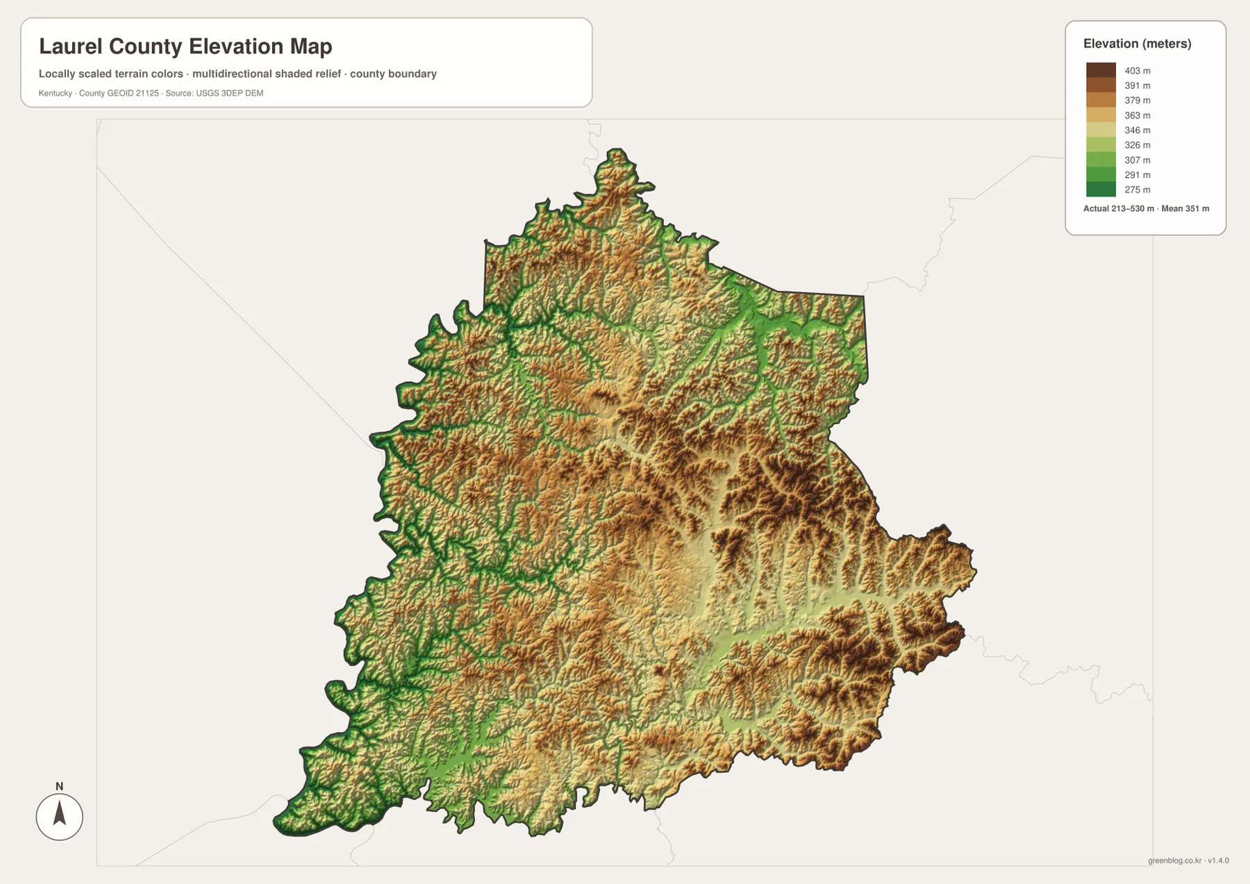
The elevation map reports an actual range of about 213 to 530 meters and a mean of 351 meters. Lower green terrain follows the Rockcastle River side, the Laurel River Lake basin, and many interior stream valleys. Higher tan and brown ridges are more common in the north, east, and southeast, giving the county a strongly dissected mountain-and-valley appearance.
London occupies comparatively moderate terrain rather than the highest ridge country. That helps explain why the central road network is broader and more connected there. Moving east toward upper Laurel River country or north toward the South Fork Rockcastle River brings denser ridges and narrower valleys, while the southwest drops toward the reservoir basin and lower drainage corridors.
Comparing the elevation image with the water map makes the drainage pattern easier to understand. Rockcastle River, Sinking Creek, Little Laurel River, and other named streams generally line up with lower bands between ridges. The elevation surface is generalized for county-scale reference, so surveying, engineering, construction, and exact parcel elevations require original USGS data or site-specific measurements.
Choose London, the lake, or the Rockcastle corridor as the starting reference
For day-to-day orientation, London is the best first reference. From there, decide whether the destination lies north along I-75 toward East Bernstadt, east along KY 80 into hill country, south toward North Corbin, or southwest toward Laurel River Lake. The Rockcastle River side is easier to interpret when the road map and water map are viewed together because the county boundary and drainage corridors both curve through rough terrain.
If the destination is Laurel River Lake, identify the reservoir on the water map first and then compare the general map around KY 192 and nearby roads. Wood Creek Lake provides another useful landmark northwest of London, while Laurel River and Robinson Creek are better references for the eastern drainage. In mountain terrain, nearby points on a simple outline can still require a long drive around ridges, so current navigation should always be checked separately.
London–Laurel County tourism promotes the area for access to Daniel Boone National Forest, Laurel River Lake, trails, and other outdoor recreation. A county map is useful for understanding the broad setting before a trip, but hours, closures, trail conditions, and access rules can change and should be verified with the current facility or agency information.
High-resolution files are better for small route and creek labels
The browser previews make the county easy to scan, but the original JPG files are more useful when you need to read smaller labels such as Routes 638, 472, and 687 or streams such as Sinking Creek and Wild Dog Creek. Enlarging the water map also gives a clearer view of the branching Laurel River Lake shoreline and the irregular Rockcastle River side of the county.
For printing or classroom use, the general map works well as the main reference and the water and elevation maps can be placed beside it for terrain context. The city map is deliberately simple, so it is especially useful when the first goal is to establish London’s position before adding the surrounding roads and natural features.
Frequently Asked Questions
What is the easiest reference point for locating places in Laurel County?
London is the easiest starting point. I-75 and KY 80 meet in the central part of the county, while East Bernstadt lies to the north and North Corbin is near the southern boundary. From London, the main road directions are easier to match with the surrounding valleys.
Which file is best for Laurel River Lake and Rockcastle River?
Use the terrain-and-water map. It labels Laurel River Lake, Little Laurel River, Laurel River, Rockcastle River, Sinking Creek, Wood Creek Lake, and several smaller tributaries. Pair it with the elevation map if you also want to compare the waterways with lower valley floors and surrounding ridges.
Can the 213–530 meter elevation image be used for surveying?
No. It is a county-scale reference image for comparing relative terrain. Surveying, engineering, construction, and exact parcel-elevation work should use current source data and professional site measurements.
Map File Information
Download the Laurel County boundary, city, terrain-and-water, and elevation maps as the original high-resolution JPG files.
- Included Files: county map, city map, terrain and water map, elevation map
Related Maps
Sources and References
County background was checked with the Kentucky.gov Laurel County profile and the London-Laurel County Tourist Commission. Lake context comes from Kentucky Tourism’s Laurel River Lake page. Boundary and road data can be referenced through U.S. Census Bureau TIGER/Line, waterways through USGS National Hydrography, and elevation through the USGS 3D Elevation Program.
Green Map creates custom-edited map images using open geographic data sources such as geoBoundaries, Natural Earth, OpenStreetMap, and government open data. These maps are edited visual materials, not raw data files, and are provided for education, documents, presentations, and graphic reference.