Johnson County lies in the steep hill country of eastern Kentucky, where Paintsville anchors a network of roads and communities tucked into narrow valleys. West Van Lear and Van Lear sit just south of Paintsville, while Keaton marks a separate northwestern valley. U.S. 23, U.S. 460, and several Kentucky routes weave through terrain that leaves little room for long straight corridors, so the county makes the most sense when roads, waterways, and relief are considered together.
The downloadable ZIP on this page contains four high-resolution JPG maps for closer viewing and printing. The larger files are especially useful for reading small route numbers, following named creeks, and comparing the Levisa Fork valley with the surrounding Appalachian ridges.
Table of Contents
Paintsville anchors a road network shaped by narrow mountain valleys
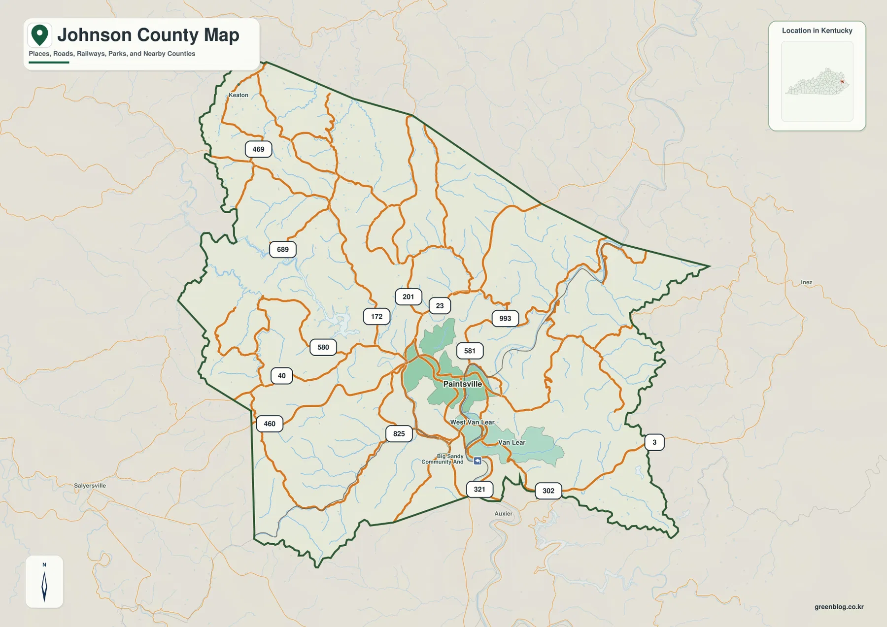
Paintsville appears slightly south of the county’s center and is the clearest orientation point on the general map. U.S. 23 runs north-south beside the city, while U.S. 460 approaches from the southwest. KY 40 crosses the western side toward Paintsville, and KY 201 and 172 reach into the hills to the north. On the east and southeast sides, KY 3, 302, and 993 follow winding routes through the dissected terrain.
West Van Lear and Van Lear are labeled close together south of Paintsville, with Big Sandy Community and Technical College providing another recognizable landmark. Keaton is farther northwest and sits in a different valley system. Instead of a broad plain filled with evenly spaced towns, Johnson County shows a linear pattern in which roads and settlements occupy the lower ground between closely packed ridges.
The county outline reinforces that impression. Its long northern edge is relatively straight, but the western and eastern sides contain many bends where the boundary meets rugged terrain. Magoffin, Floyd, Morgan, Lawrence, Elliott, Martin, and Pike counties surround Johnson County, so the road map is also useful for understanding which direction each valley connection continues beyond the county line.
The city view shows one dominant hub rather than several competing centers
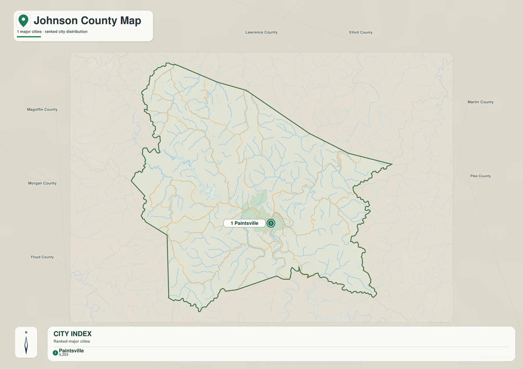
The city map identifies only one major city: Paintsville. Its printed reference value is 4,203. That figure should be treated as a value embedded in the supplied map rather than as a claim about the newest population estimate. The more important point is the spatial one: Paintsville is clearly the county’s primary urban marker.
With only one city emphasized, navigation works differently here than in counties that have several similarly sized towns. The practical question is usually not the distance between multiple urban centers, but which valley and route lead away from Paintsville. U.S. 23 provides the strongest north-south reference, U.S. 460 and KY 40 connect toward the west and southwest, and smaller state routes branch into the hills on both sides.
Van Lear and West Van Lear remain important local labels even though they are not ranked separately on the city index. Their position south of Paintsville, close to the Levisa Fork corridor, helps explain why the general county map is the better file for local place names while the city map is best for seeing the county’s single dominant center without clutter.
Levisa Fork gathers a dense web of creeks from the surrounding ridges
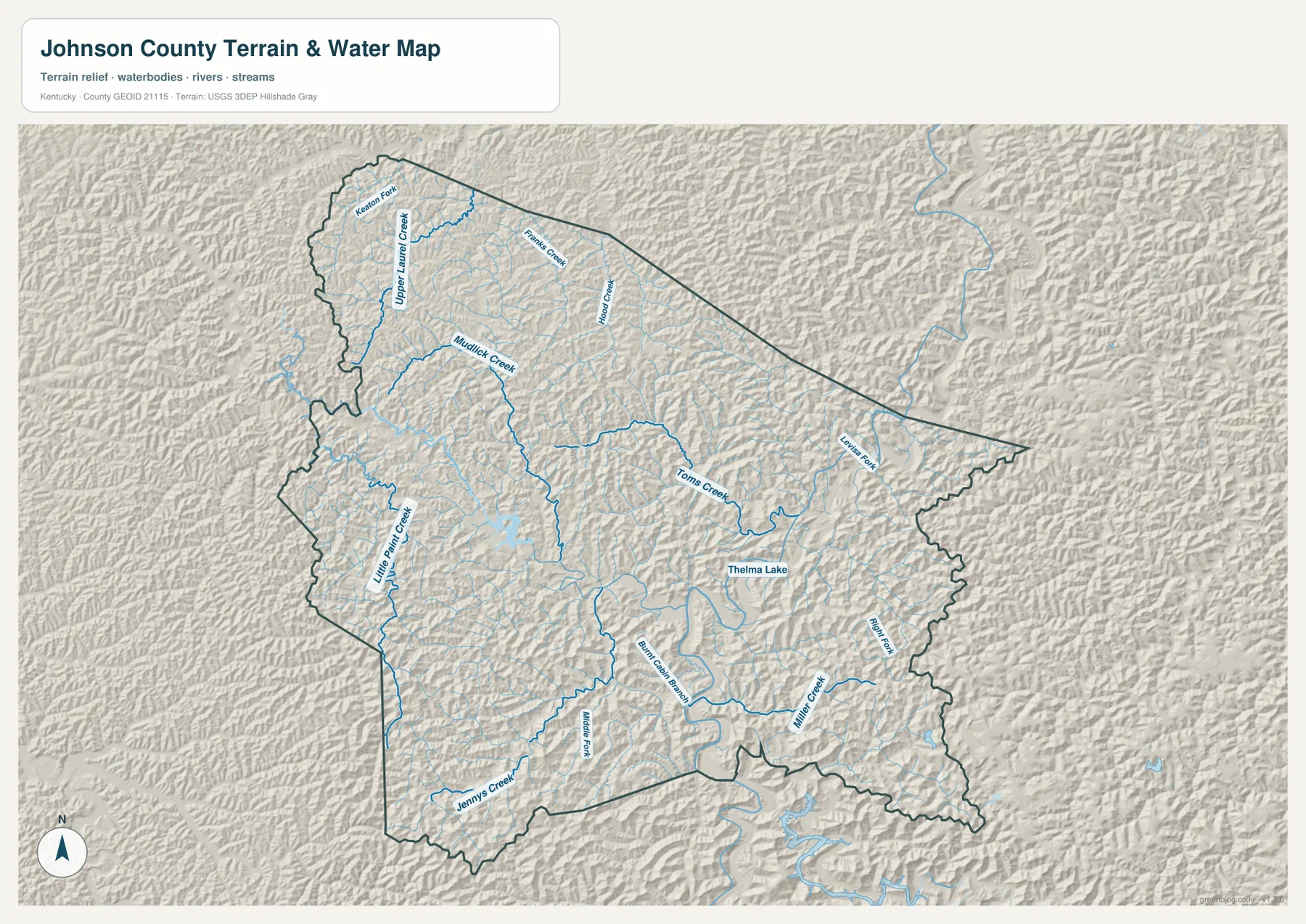
Levisa Fork is the largest named watercourse on the terrain-and-water map. It enters from the east, bends toward Paintsville, and continues south through the county. Many smaller streams descend from the ridges into this corridor. In the north, Keaton Fork, Upper Laurel Creek, Franks Creek, and Hood Creek occupy separate valleys, while Mudlick Creek extends southward from the northwestern hills.
Toms Creek is one of the clearest central tributaries and curves toward the Levisa Fork system. Little Paint Creek lies to the west, and Jenny’s Creek appears farther southwest. South and southeast of Paintsville, the map labels Burnt Cabin Branch, Middle Fork, Miller Creek, and Right Fork. Thelma Lake provides a named still-water feature among the many narrow stream corridors.
The waterways also help explain the road pattern. Routes frequently share the same low corridors as streams or cross near tributary junctions because the surrounding ridges rise quickly. This map is designed for general geographic reference, not for flood-zone decisions, live water levels, navigation, property boundaries, or engineering work. Those tasks require current agency products and purpose-specific data.
Elevation rises from about 174 meters in the valleys to 456 meters on the ridges
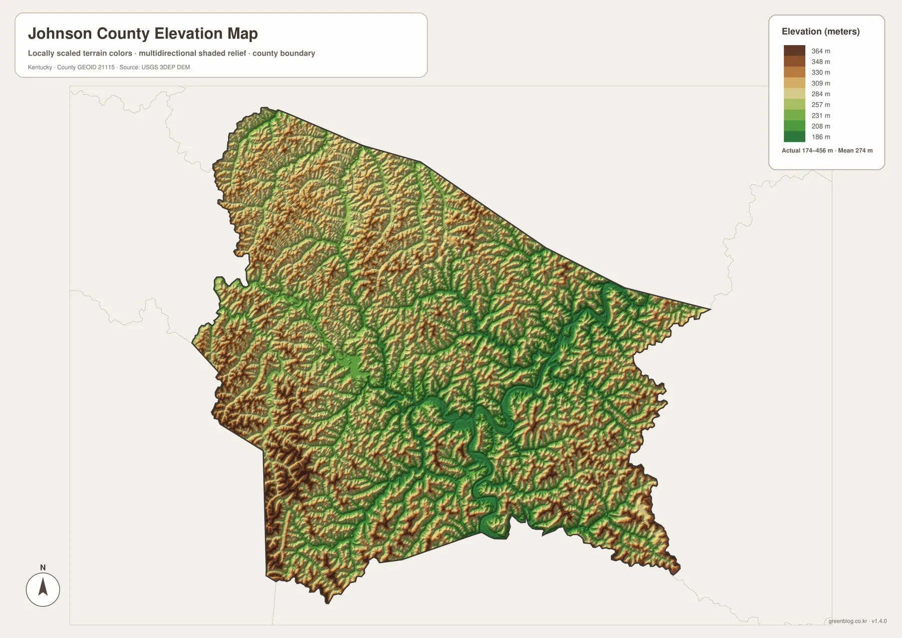
The elevation map reports an actual range of about 174 to 456 meters and a mean of 274 meters. Green lowlands trace the Levisa Fork and major tributaries as narrow, winding bands, while tan and brown ridges rise between them. The result is a landscape with repeated short climbs and drops rather than one smooth slope across the county.
High ground is especially extensive in the western and northwestern parts of the county, while the southeast also contains closely spaced ridges separated by narrow drainage corridors. Paintsville occupies comparatively low ground along the Levisa Fork, but elevations increase quickly away from the river. Toms Creek, Mudlick Creek, and Miller Creek line up closely with the greener low-elevation corridors on the relief map.
The mean elevation of 274 meters can hide how much local relief exists. The map spans roughly 282 meters from its lowest to highest mapped values, and that difference helps explain why roads curve through valleys instead of crossing every ridge directly. The surface is generalized for county-scale comparison and should not be used as survey-grade elevation, an engineering model, or an exact parcel measurement.
Local resources add context to the road-and-valley geography
Johnson County’s official website places county government in Paintsville and also links residents to county road maps, trails, and other local services. Those resources fit the geography shown here: Paintsville is the natural starting point for understanding how the county’s valleys connect. Paintsville Tourism likewise emphasizes mountain scenery and outdoor recreation in the surrounding eastern Kentucky landscape.
For practical orientation, start with Paintsville and identify the valley containing the destination. U.S. 23 and KY 201 or 172 provide useful northern references, KY 40 and U.S. 460 help organize the western side, and KY 3, 302, and 993 serve the east and southeast. Keeping the water map open at the same time makes it easier to see which road corridor follows a named creek or the Levisa Fork.
Static maps cannot show every changing condition in a mountainous county. Construction, closures, weather, and facility access may change, so current transportation and local government information should be checked before a trip. The maps here are best used to establish the county’s basic road, settlement, water, and terrain relationships before consulting live sources.
High-resolution JPG files make small road and creek labels easier to compare
The general county map is the best starting point for boundaries, roads, and local place names because it keeps Paintsville, West Van Lear, Van Lear, Keaton, U.S. 23, U.S. 460, and the principal numbered routes on one page. The city map is intentionally simpler and works well when the goal is simply to identify the county’s primary urban hub.
For waterways, the terrain-and-water map provides the clearest labels for Levisa Fork, Toms Creek, Mudlick Creek, Upper Laurel Creek, Little Paint Creek, Miller Creek, and other tributaries. Pairing it with the elevation map shows where those streams occupy lower corridors and where the ridges rise around them. The WebP versions are convenient for quick browsing, while the downloadable JPG originals are better for enlarging labels, printing, and side-by-side study.
Frequently Asked Questions
What is the easiest orientation point in Johnson County?
Paintsville is the clearest starting point. It is the county’s only ranked major city on the supplied city map, U.S. 23 passes nearby, and the Levisa Fork corridor runs through the same part of the county. From Paintsville, Van Lear and West Van Lear lie to the south while Keaton is farther northwest.
Which file is best for Levisa Fork and the named creeks?
The terrain-and-water map is the best choice. It labels Levisa Fork, Toms Creek, Mudlick Creek, Upper Laurel Creek, Little Paint Creek, Miller Creek, Thelma Lake, and several smaller forks and branches. Comparing it with the elevation map also shows how those waters occupy lower valleys between the ridges.
Can the 174–456 meter elevation map be used for surveying or construction?
No. It is a generalized county-scale elevation map for comparing valleys and ridges. Exact site elevations, engineering design, construction, flood analysis, and parcel surveys require original data or professional measurements.
Map File Information
Download the Johnson County general, city, terrain-and-water, and elevation maps as high-resolution JPG originals.
- Included Files: county map, city map, terrain-and-water map, elevation map
Related Maps
Sources and References
Local context is available from Johnson County and Paintsville Tourism. Boundary and road references are supported by U.S. Census Bureau TIGER/Line, water features by USGS National Hydrography, and elevation data by the USGS 3D Elevation Program.
Green Map creates custom-edited map images using open geographic data sources such as geoBoundaries, Natural Earth, OpenStreetMap, and government open data. These maps are edited visual materials, not raw data files, and are provided for education, documents, presentations, and graphic reference.