Hickman County occupies a low, rural corner of western Kentucky where Clinton serves as the central town while Columbus sits beside the Mississippi River in the northwest. U.S. 51 crosses the county from north to south, and state routes such as KY 58, KY 80, KY 123, KY 288, KY 703, KY 780, and KY 944 branch into farming areas and creek valleys. This page explains the four supplied maps using features visible on the files themselves, and the high-resolution JPG versions can be downloaded together in one ZIP after reviewing the web previews. High-resolution map files are available for download in the section below.
The county is easier to understand when Clinton and Columbus are treated as two different anchors. Clinton lies close to the middle of the county and sits near the meeting of U.S. 51, KY 123, and several local routes. Columbus is far to the northwest, close to a broad bend of the Mississippi River. Between them, the landscape changes from very low river bottoms to a more dissected interior where short ridges and creek valleys become increasingly visible toward the east and southeast.
Table of Contents
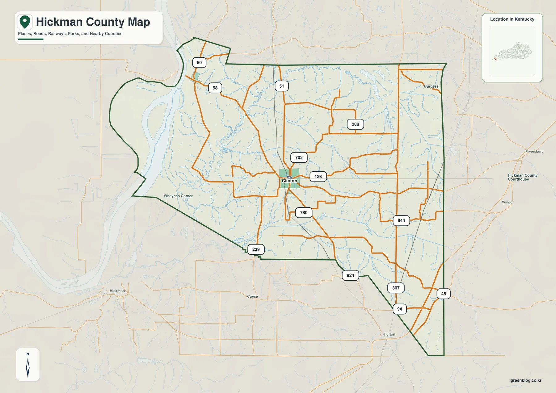
U.S. 51 makes Clinton the clearest road reference inside Hickman County
On the county map, Clinton is the easiest place to use as an orientation point. U.S. 51 enters from the north, passes through the central part of the county, and continues south toward the Tennessee line. KY 123 crosses the Clinton area, while KY 703 and KY 780 handle shorter connections nearby. Farther east, KY 288 and KY 944 reach through rural areas where the road network becomes more irregular as it follows small valleys and field boundaries.
The northwestern side has a different pattern. KY 58 and KY 80 provide access toward Columbus and the Mississippi River, while the southern edge shows KY 239 and KY 924. KY 307 and KY 94 appear near the southeastern corner, and U.S. 45 is visible just beyond the county near Fulton. Looking at these routes together shows why Clinton functions well as a central reference: it is not the only road junction, but it is the place from which the county’s northern, eastern, western, and southern sections are easiest to compare.
The western boundary is strongly shaped by the Mississippi River and does not resemble a simple straight county line. Large bends create a broad protruding area along the river, while the eastern boundary is comparatively long and direct. Neighboring labels for Carlisle County, Graves County, and Fulton County help place Hickman County within the far-western Kentucky landscape.
Clinton and Columbus define a sparse two-city pattern
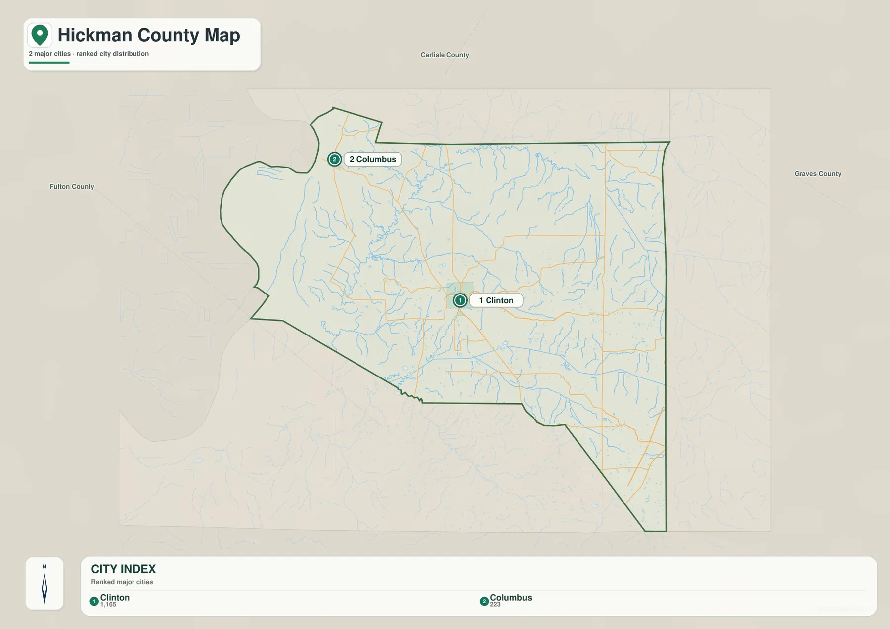
The city-distribution map emphasizes only two major places: Clinton and Columbus. The reference values printed on the map are 1,165 for Clinton and 223 for Columbus. Those figures are best treated as values embedded in the map rather than as a substitute for the latest Census estimates. Their main purpose here is to show the large difference between the county’s central town and the much smaller river community in the northwest.
Clinton is surrounded by the denser portion of the county road network and provides a practical starting point for locating the interior. Columbus is separated from it by miles of rural land and lies much closer to the Mississippi River corridor. With no other large city marker between them, the map presents Hickman County as a place of small centers surrounded by broad agricultural and natural areas rather than as a continuous urban corridor.
Columbus also has a distinctive geographic setting because Columbus-Belmont State Park stands above the Mississippi River there. Kentucky State Parks describes the site as a historic river-bluff park associated with the Battle of Belmont and Civil War earthworks. That background fits what the county maps show: Columbus is not simply a second town marker but a useful reference for the transition between low river land and the higher edge overlooking the river.
Mississippi River lowlands give way to an interior network of creeks
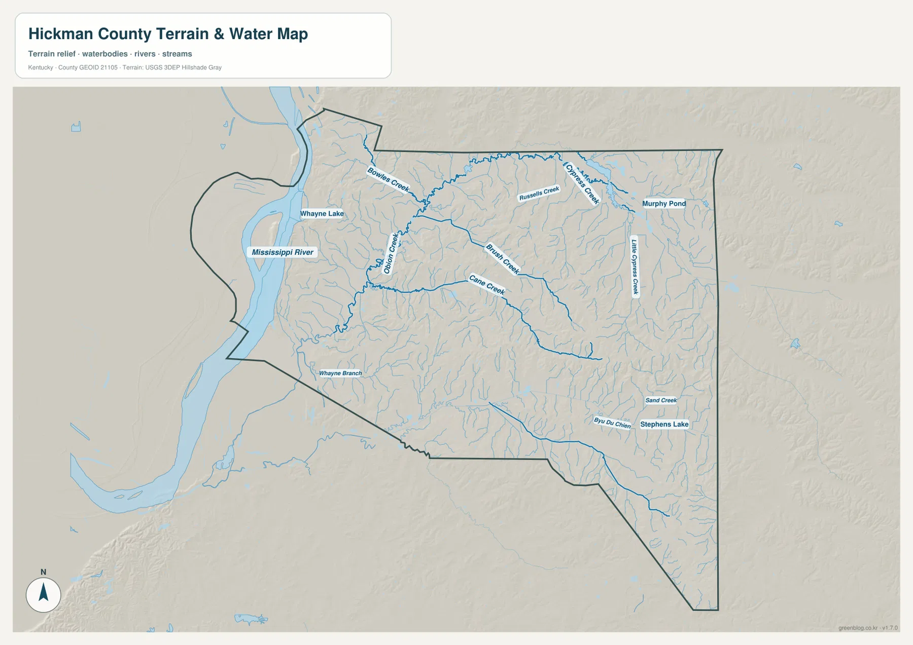
The terrain-and-water map is dominated by the Mississippi River along the west. Its broad channel and sweeping bends border a flat lowland zone that is visually different from the interior. Whayne Lake appears near the northwestern side, and Bowles Creek and Obion Creek drain through nearby valleys. These features make the river side of Hickman County look open and low compared with the more finely divided terrain farther east.
Inside the county, Russell Creek and Brush Creek cross the north-central area, while Cane Creek reaches through the middle. Little Cypress Creek is labeled toward the northeast, and Sand Creek and Bayou du Chien appear in the southeastern part of the map. Murphy Pond and Stephens Lake add smaller water bodies to the same picture. The number of named creeks makes it clear that the county’s inland terrain is cut by many short drainage valleys even though the Mississippi is by far the largest water feature.
The water map works well alongside the road map because several rural roads follow or cross these low corridors. It should not be treated as a flood-hazard map, a parcel map, or a navigation chart. River stages, flood zones, engineering drainage decisions, and property boundaries require current information from the agencies responsible for those subjects.
An 88–156 m elevation range separates the river floor from eastern ridges
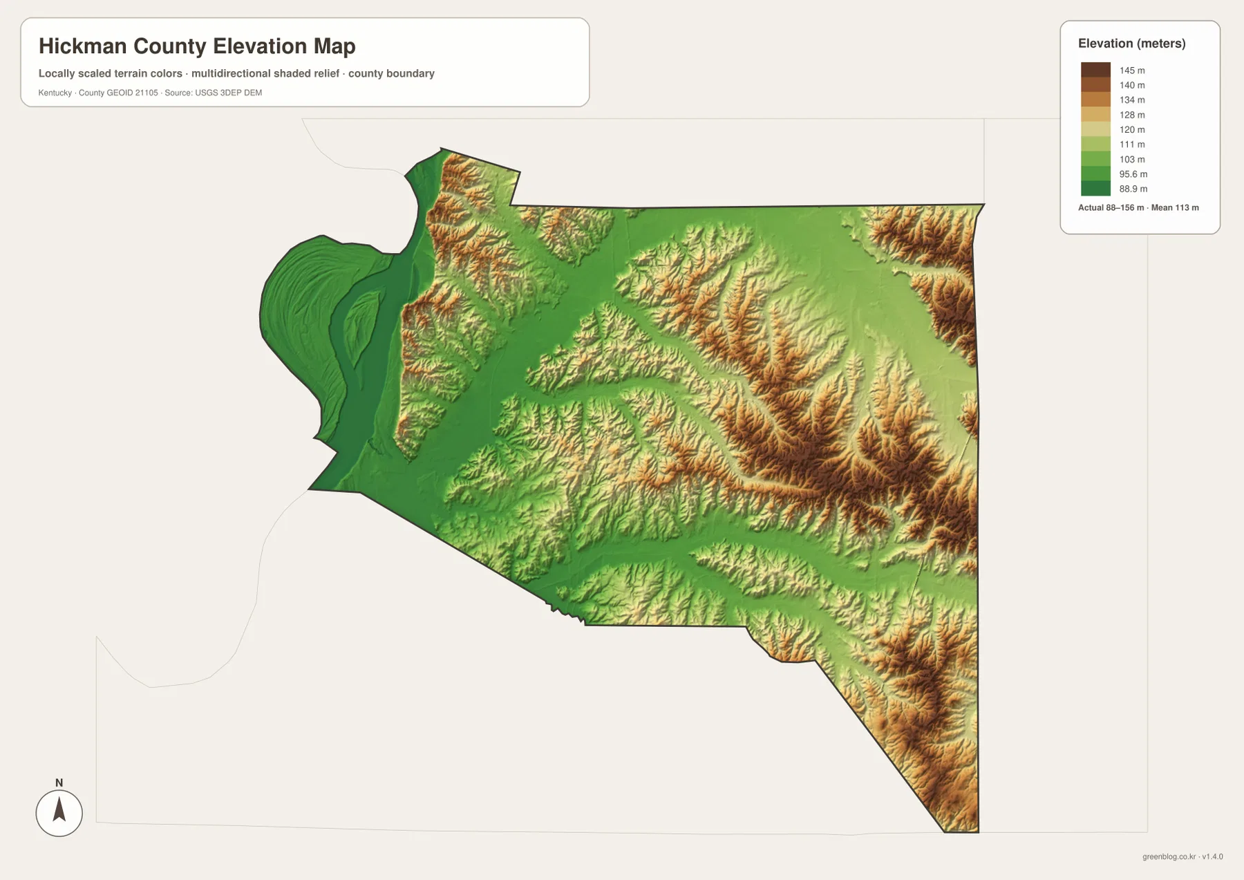
The elevation map shows an actual range of about 88 to 156 meters, with a mean of 113 meters. The lowest green terrain is concentrated along the Mississippi River and the broad western lowlands. This area has relatively little relief compared with the rest of the county, especially around the large river bends and the flat land immediately inland from them.
Higher ground becomes more common toward the east and southeast. Brown and tan ridges are especially visible in the east-central section and near the southeastern corner, while narrow green valleys wind between them. The same pattern can be matched with Russell Creek, Cane Creek, Little Cypress Creek, and other waterways on the water map. Those creeks occupy lower corridors, and the ridge tops rise between them.
The mean elevation of 113 meters does not mean the county is uniformly flat. A visitor moving from the Mississippi side toward the eastern interior would pass from broad low ground into rolling terrain with repeated short ridges. This generalized elevation surface is intended for county-scale comparison, not survey work. Exact site elevations, construction planning, flood analysis, or engineering design should rely on original elevation data or professional measurements.
The county’s river history and rural interior meet at two very different places
Clinton and Columbus reveal two sides of Hickman County. Clinton is an inland service center surrounded by roads, farms, and small streams. Columbus is tied directly to the Mississippi River, its bluffs, and the history preserved at Columbus-Belmont State Park. Reading the maps with those two places in mind makes the county’s geography much more concrete than treating it as a single uniform block of western Kentucky.
Local Hickman County information describes the county as part of far western Kentucky near Tennessee, Missouri, and the Mississippi River, with a strong agricultural background and Great River Road connections. The maps support that broad setting without requiring every road or creek to be memorized. Clinton provides the interior anchor, Columbus represents the river edge, and the eastern half is characterized by smaller creeks and more rolling relief.
This contrast also explains why the four files serve different purposes. A road map is best for tracing U.S. 51 and the state highways, while the city map removes much of that detail so Clinton and Columbus stand out immediately. The water map exposes the creek network that is easy to miss beneath roads, and the elevation map shows why the Mississippi side feels flatter than the eastern interior.
Choose the map file according to the detail you need
For county boundaries, roads, and neighboring places, start with the general county map. It keeps Clinton, Columbus, U.S. 51, and the main state routes on the same page, making it suitable for classroom handouts, trip planning at a broad scale, or county-location explanations. The city map is better when the only question is where the county’s two principal city markers lie relative to each other and to the county outline.
The terrain-and-water map is the strongest choice for the Mississippi River, Bowles Creek, Obion Creek, Russell Creek, Brush Creek, Cane Creek, and smaller lakes or ponds. Pairing it with the elevation file helps distinguish low valleys from higher ridges. This combination is useful for geographic study and general landscape interpretation, but it does not replace real-time hydrology, flood mapping, land surveys, or engineering-grade terrain data.
The WebP images on this page are optimized for quick viewing. The downloadable ZIP contains the high-resolution JPG originals, which are more practical when small road numbers or creek labels need to be enlarged or printed. Keeping the files separate also makes side-by-side comparison easier, especially when matching the road network to waterways or the water map to the 88–156 meter elevation surface.
Frequently Asked Questions
Which place is the easiest starting point on a Hickman County map?
Clinton is the simplest starting point because it lies near the center of the county and is closely associated with U.S. 51, KY 123, and several local connections. Once Clinton is located, Columbus can be found to the northwest near the Mississippi River, making the difference between the inland center and river edge easy to understand.
Which map best shows the Mississippi River and Hickman County creeks?
The terrain-and-water map provides the clearest view. It shows the Mississippi River together with Bowles Creek, Obion Creek, Russell Creek, Brush Creek, Cane Creek, Little Cypress Creek, and other named waterways. For the relationship between those valleys and higher land, compare it with the elevation map.
Can the elevation map be used for surveying or flood decisions?
No. The elevation map is a county-scale reference showing an actual range of about 88–156 meters and a mean of 113 meters. Surveying, construction, flood-risk decisions, and precise site elevations require original agency data or professional measurements rather than this generalized map.
Map File Information
Download the Hickman County general, city, terrain-and-water, and elevation maps as high-resolution JPG originals.
- Included Files: county map, city map, terrain-and-water map, elevation map
Related Maps
Sources and References
County background information can be found at Explore Hickman County and the Kentucky State Parks page for Columbus-Belmont State Park. Boundary and road references come from U.S. Census Bureau TIGER/Line, water features can be checked against USGS National Hydrography, and elevation data are supported by the USGS 3D Elevation Program.
Green Map creates custom-edited map images using open geographic data sources such as geoBoundaries, Natural Earth, OpenStreetMap, and government open data. These maps are edited visual materials, not raw data files, and are provided for education, documents, presentations, and graphic reference.