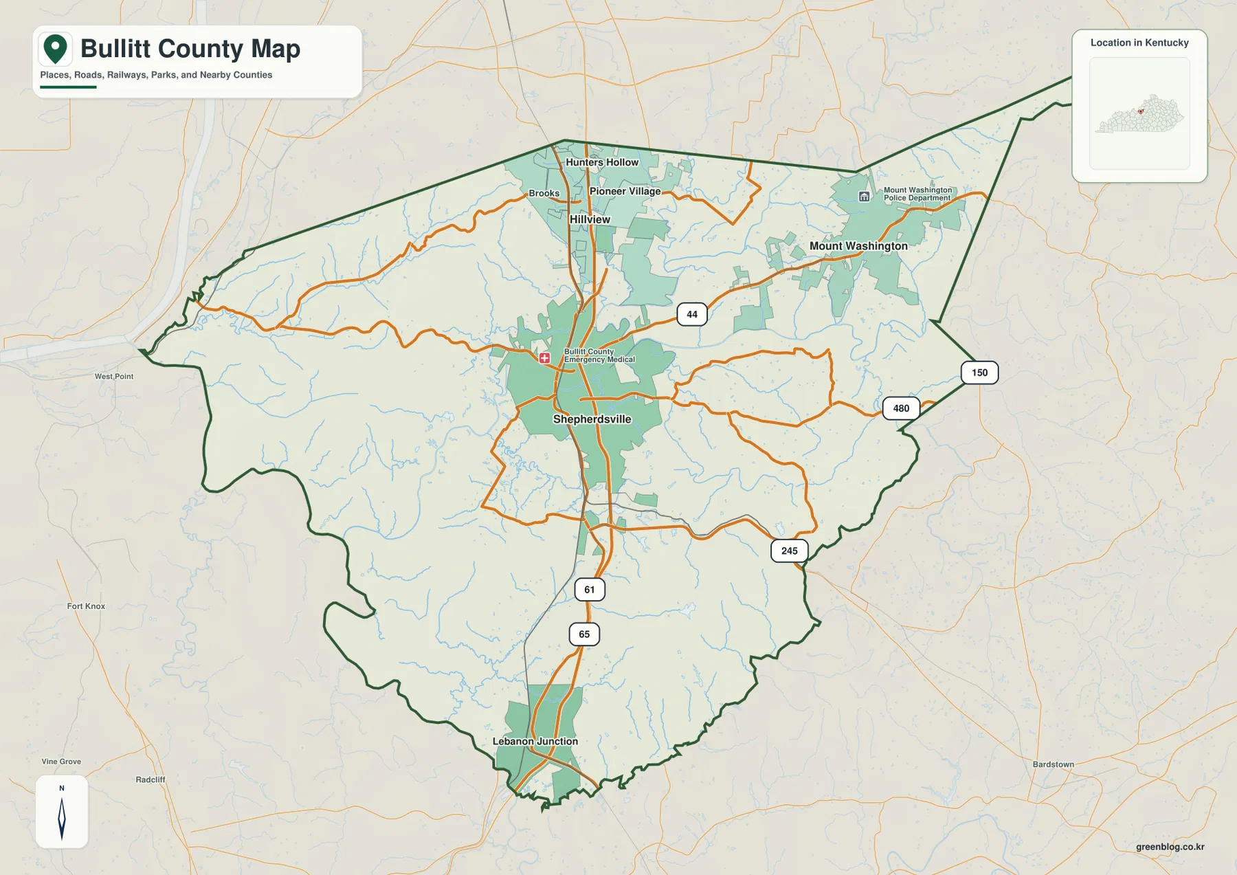
Bullitt County sits immediately south of Louisville in north-central Kentucky, and its map becomes easy to understand once a few places are fixed in mind. Shepherdsville occupies the middle of the county along I-65 and US 61, several northern communities cluster near the Jefferson County side, Mount Washington stands apart to the northeast, and Lebanon Junction marks the south. The Salt River and its tributaries cross the county between low valleys and higher ridge country, so roads, towns, streams, and elevation make more sense when viewed together rather than as separate lists.
The maps used on this page are also available as high-resolution JPG files in the download box below. The package includes a county reference map, a major-city map, a terrain-and-water map, and an elevation map covering the same area. They are useful for printing, classroom work, reports, and general geographic reference. They are not replacements for parcel surveys, real-time navigation, flood-hazard products, engineering plans, or other site-specific authoritative data.
Table of Contents
Start with Shepherdsville, then follow the county north and south
Shepherdsville is the simplest place to begin because it lies near the middle of Bullitt County and is crossed by the county’s strongest north-south transportation lines. I-65 and US 61 pass through this central area, making the city a useful reference point for locating communities in every direction. Moving north on the map brings Hillview, Brooks, Pioneer Village, Hunters Hollow, and other closely spaced places into view. Mount Washington is separated from that group on the northeastern side, while Lebanon Junction lies much farther south.
The road network adds a second layer of orientation. KY 44 runs east-west through the Shepherdsville area and continues toward Mount Washington, while KY 480 and KY 245 appear on the eastern side of the county. Farther south, I-65 and US 61 continue toward Lebanon Junction. The northern portion looks busier because more communities and local roads are packed into a relatively small area near Louisville, whereas the southern half has more space between named places. That contrast is one of the clearest things the full county map communicates.
If road numbers are not important, the city map offers a cleaner view. It highlights Mount Washington, Shepherdsville, Hillview, Pioneer Village, Lebanon Junction, and Hebron Estates, making the county’s settlement pattern obvious at a glance. Several of the highlighted communities occupy the northern half, Shepherdsville sits near the center, and Lebanon Junction is clearly separated to the south. Mount Washington is easy to distinguish because it lies northeast of the main I-65 line rather than directly along it.
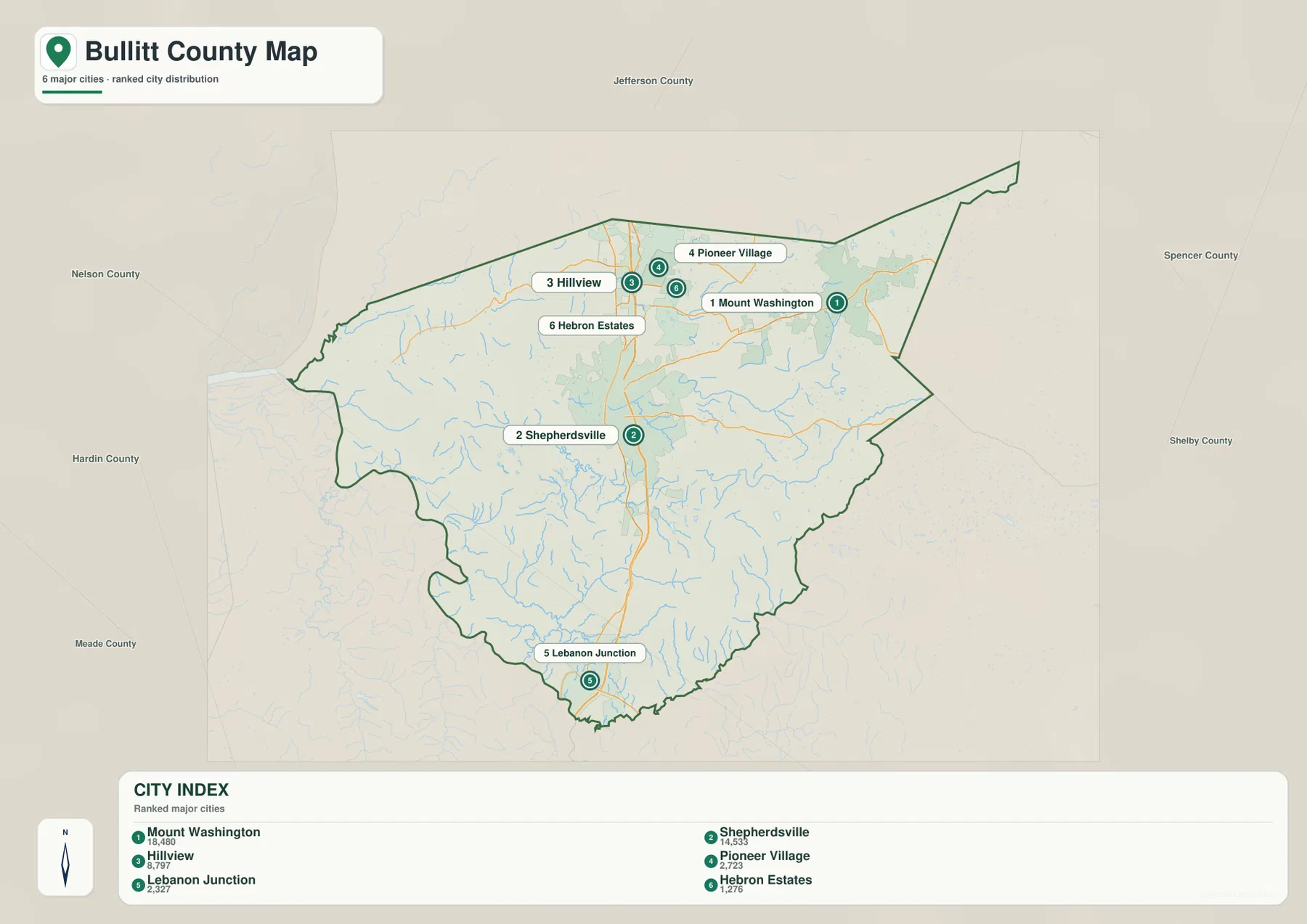
The two views are useful for different questions. Use the city map when the goal is simply to show where the main communities sit relative to one another. Return to the county map when you need to explain how those places connect. Shepherdsville and Mount Washington, for example, appear as central and northeastern points on the city map, while the reference map adds KY 44 and the surrounding roads. Lebanon Junction is similarly easier to place once the southbound I-65 and US 61 lines are visible.
The Salt River ties together a network of creeks and small lakes
The Salt River is the main water feature on the Bullitt County terrain-and-water map. It crosses the central part of the county and provides a useful landmark for understanding many of the smaller streams. Knob Creek is prominent in the northwest, Brook Run and Cedar Creek appear farther north and toward the center, Long Lick Creek extends through the central-to-southern part of the county, and Crooked Creek is visible farther south. Numerous smaller channels fill in the spaces between those named waterways.
Several small lakes are labeled as well, including Bills Lake, Kings Lake, Duck Lake, Wilcox Lake, Hudic Lake, Bargers Lake, Everback Lake, and Lake Nevin. These are not shown as one dominant reservoir system. Instead, they work as local landmarks within the larger pattern of streams and valleys. For someone unfamiliar with the county, matching these water names with the road map can make it easier to understand where a community or route sits in relation to the Salt River and nearby creeks.
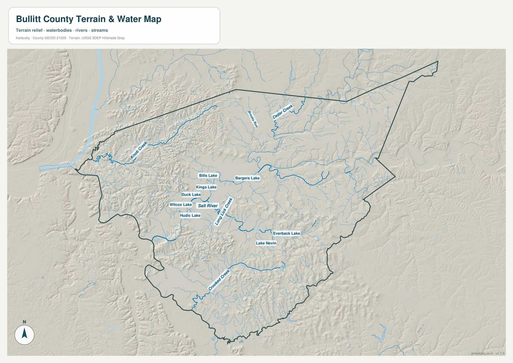
Shepherdsville is especially helpful as a shared reference between the transportation and water maps because the city sits close to the Salt River and the main north-south road corridor. To the northwest, Knob Creek occupies a different part of the county, while Long Lick Creek and Crooked Creek help define the southern half. The smaller road network often bends rather than forming a strict grid, and the combination of hills and streams helps explain why. Local roads do not simply follow every creek, but they frequently have to work around valleys, slopes, and crossings.
This water map is intended for geographic orientation. It does not identify regulatory flood zones, current river stage, water quality, navigable depth, private ownership, or emergency conditions. Anyone making a safety, insurance, construction, or boating decision should use current information from FEMA, USGS, Kentucky agencies, or the appropriate local authority.
Elevation ranges from about 111 to 299 meters
The elevation map spans roughly 111 to 299 meters, with an average near 176 meters. Lower colors spread through the central Salt River area and along several tributary valleys, including the broad lower ground around Shepherdsville. Higher terrain is much more noticeable in the west and northwest, where closely spaced ridges create frequent changes in color. Additional higher ground appears in the southeastern and eastern parts of the county, so Bullitt County does not simply rise in one direction from low to high.
Along the western side, short ridges and narrow valleys alternate repeatedly. Near Lebanon Junction, lower ground is visible along the southern transportation route, but hills rise again nearby. The Mount Washington side is also more varied than a plain road map might suggest, with moderate uplands broken by lower stream courses. These differences matter when interpreting distance. Two places can be close on a straight line while local roads take a less direct path because they must cross or avoid ridges and drainage lines.
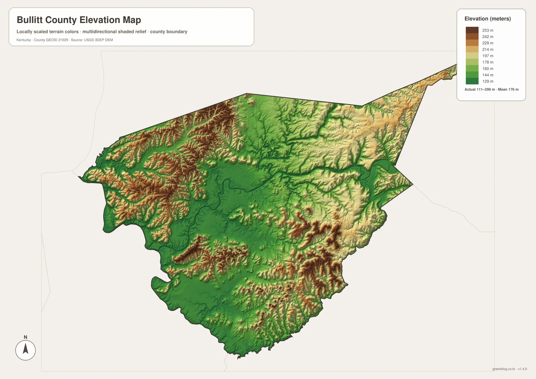
The easiest way to use the elevation map is beside the water map. Find the Salt River, Long Lick Creek, or another named stream, then compare the same location on the elevation colors. Many larger stream courses coincide with lower ground, while tan and brown ridges occupy the land between them. This makes the physical shape of the county easier to explain than a simple statement that one side is higher than another. The central valleys are generally lower, while substantial ridge country appears around them, especially in the west and southeast.
The elevation surface is generalized for countywide comparison, not for site design. It is appropriate for seeing broad differences in relief and for adding terrain context to roads and waterways. It is not accurate enough to determine the exact elevation of a building lot, a road grade, drainage infrastructure, excavation requirements, or legal survey points. Those tasks require higher-resolution authoritative elevation data and, when necessary, field measurements.
Choose the map that matches the question
For a first look at Bullitt County, begin with Shepherdsville and I-65 on the reference map. Then locate Hillview and Pioneer Village to the north, Mount Washington to the northeast, and Lebanon Junction to the south. That sequence establishes the county’s basic geography without requiring every minor place name. If the only question is where the larger communities are concentrated, switch to the city map and the pattern becomes even clearer.
For rivers and terrain, use the Salt River as the common landmark between the water and elevation maps. Knob Creek, Cedar Creek, Long Lick Creek, and Crooked Creek can be found on the water layer and then compared with nearby low and high ground on the elevation layer. This is useful for classroom explanations, local-history context, or general geographic orientation because it connects familiar place names with the physical setting rather than presenting them as unrelated labels.
Keeping the four maps separate also makes printed material easier to read. The county reference map works best for roads and general orientation, the city map for community distribution, the water map for named streams and lakes, and the elevation map for relative relief. Because every file covers the same county boundary, readers can move from one view to another while keeping Shepherdsville, Mount Washington, Lebanon Junction, and the other major landmarks in the same general position.
Frequently Asked Questions
Where are Shepherdsville and Mount Washington on the map?
Shepherdsville is near the center of Bullitt County along I-65 and US 61, while Mount Washington is northeast of it. The city map is the quickest way to compare their positions. The county reference map is better when you also want to see KY 44 and the surrounding road connections.
Which waterways are labeled besides the Salt River?
The terrain-and-water map labels Knob Creek, Brook Run, Cedar Creek, Long Lick Creek, and Crooked Creek, along with several small named lakes. The map is meant to show geographic location and terrain context, not flood limits, water depth, water quality, or navigation conditions.
Can the 111–299 meter elevation range be used for surveying or construction?
No. The countywide elevation map is useful for comparing lower river valleys with higher ridge areas, but it is not survey-grade. Building design, road grading, drainage work, and legal surveying require more detailed authoritative elevation data and, where appropriate, field measurements.
Map File Information
The original Bullitt County maps used on this page are packaged as high-resolution JPG files. Each source image is 3638 × 2572 px, providing more detail than the WebP previews for printing, classroom material, and document work.
- Included Files: county reference map, city map, terrain-and-water map, elevation map
- File Type: JPG
Related Maps
Sources and references
Local administrative and community information is available from Bullitt County Government, the Kentucky.gov Bullitt County profile, and Bullitt County Tourism’s local information page. Boundary background data can be reviewed through the U.S. Census Bureau TIGER/Line program, water data through USGS National Hydrography, and elevation data through the USGS 3D Elevation Program.
Green Map creates custom-edited map images using open geographic data sources such as geoBoundaries, Natural Earth, OpenStreetMap, and government open data. These maps are edited visual materials, not raw data files, and are provided for education, documents, presentations, and graphic reference.