Sumner County occupies south-central Kansas along the Oklahoma line, with Wellington serving as the main city and county-seat reference. US 81 and US 160 meet in Wellington, Interstate 35 runs through the eastern half, and smaller communities such as Conway Springs, Belle Plaine, Caldwell, Oxford, and Argonia are spread across a broad agricultural landscape. The Arkansas, Ninnescah, and Chikaskia river systems divide that landscape into distinct low corridors. High-resolution map files are available for download in the section below.
This guide follows Wellington and the surrounding communities across the road, water, and elevation views, with terrain ranging from about 317 to 460 meters. WebP previews are available for quick viewing, and the matching high-resolution JPG files can be downloaded together in one ZIP for printing, classroom work, or offline reference.
Table of Contents
Wellington anchors the county where US 81 and US 160 meet
Wellington sits slightly east of the county center, where US 81 crosses US 160. US 81 provides the main north–south reference toward Belle Plaine and the Oklahoma line, while US 160 links Argonia and Mayfield on the west with Oxford on the east. Interstate 35 runs farther east and connects the county with the larger Wichita–Oklahoma transportation corridor.
The Kansas Historical Society identifies Wellington as the Sumner County seat. Several early communities competed for that role, but Wellington eventually became the permanent administrative center. The modern map reinforces that history because highways, rail lines, local streets, and the largest urban footprint all concentrate around the city.
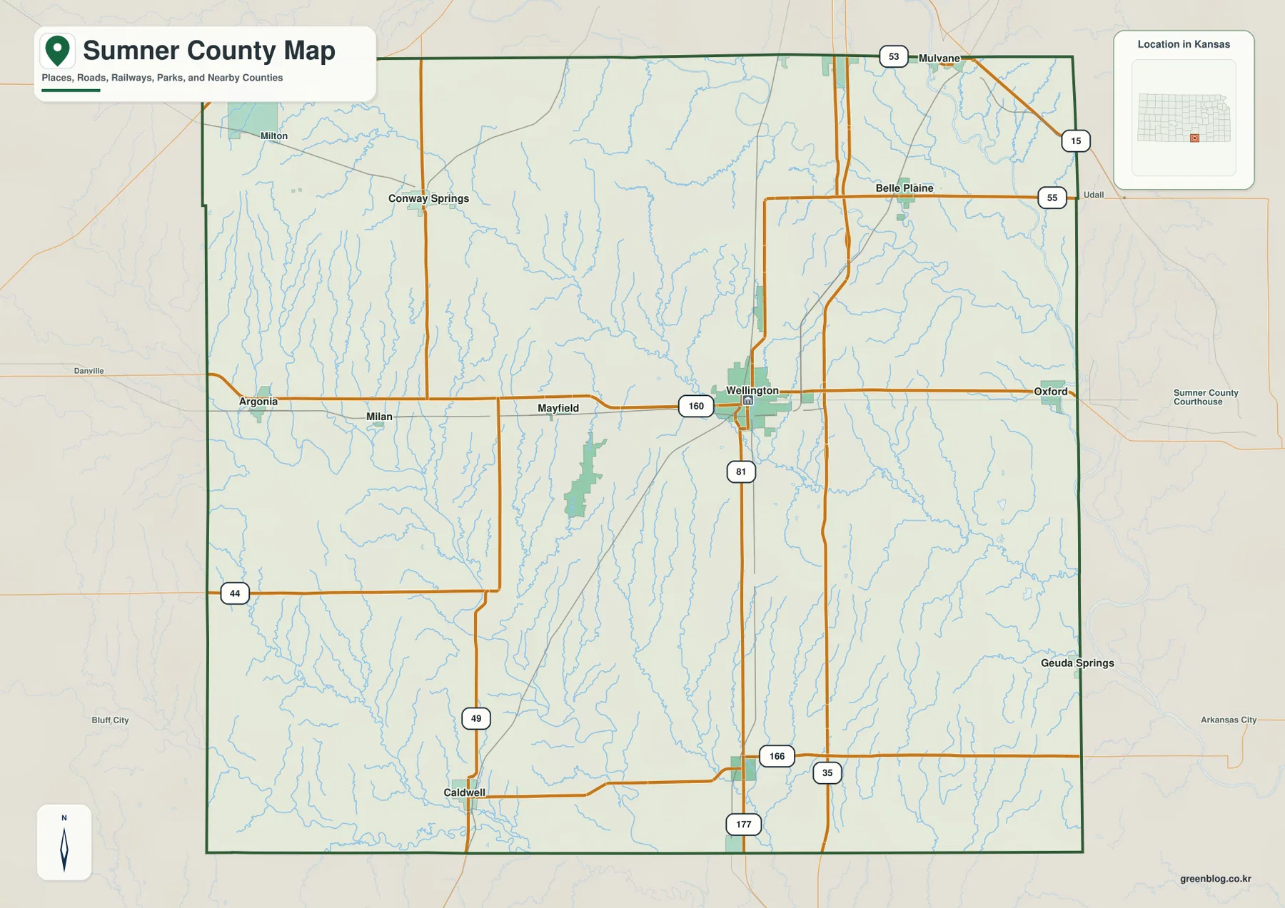
Conway Springs occupies the northwest, Belle Plaine lies in the northeast, and Caldwell sits near the southern Oklahoma line. Oxford marks the eastern US 160 corridor, while Argonia provides a western rural reference. The communities are widely dispersed, so the highway grid and river valleys are often as useful as town names for orientation.
Wellington clearly leads the six-city index
The ranked city panel lists Wellington at 7,615, Conway Springs at 1,573, Belle Plaine at 1,494, Caldwell at 977, Oxford at 964, and Argonia at 542. These are map index values rather than current official population estimates, but they show the large gap between the county seat and the smaller communities.
Caldwell and Oxford have similar index values despite occupying opposite sides of the county. Caldwell belongs to the southern border country, while Oxford lies closer to the eastern river lowlands. Conway Springs and Belle Plaine provide the strongest northern settlement references, and Argonia anchors the western side.
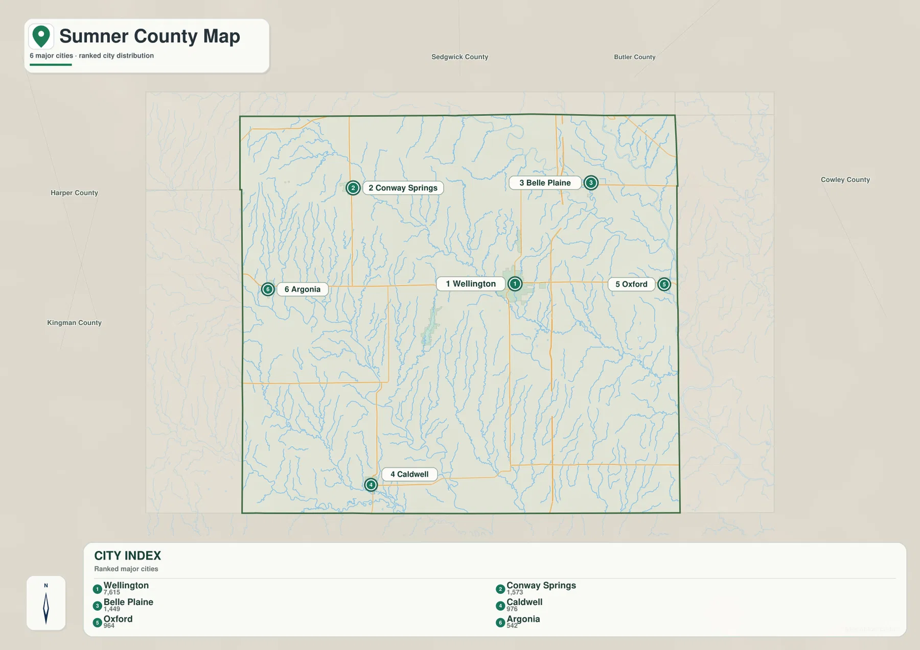
The City of Wellington also describes Wellington as the county seat and largest community in Sumner County. The city’s official census population and the supplied map index are different datasets and should not be treated as interchangeable, but both reflect Wellington’s dominant service role.
The Arkansas and Ninnescah rivers shape the east while the Chikaskia crosses the south
The water map shows the Arkansas River and Ninnescah River as the strongest eastern drainage features. Their broad lowlands extend along the east and northeast, where many short tributaries join the larger channels. Oxford and Belle Plaine sit closer to this side of the county than the higher western communities.
The Chikaskia River forms another major corridor through the south-central county. Wellington Lake lies west of Wellington, while Mission Fly Creek and Middle Spring Creek descend toward the southern drainage. Spring Creek and Silver Creek cut long valleys through the western uplands.
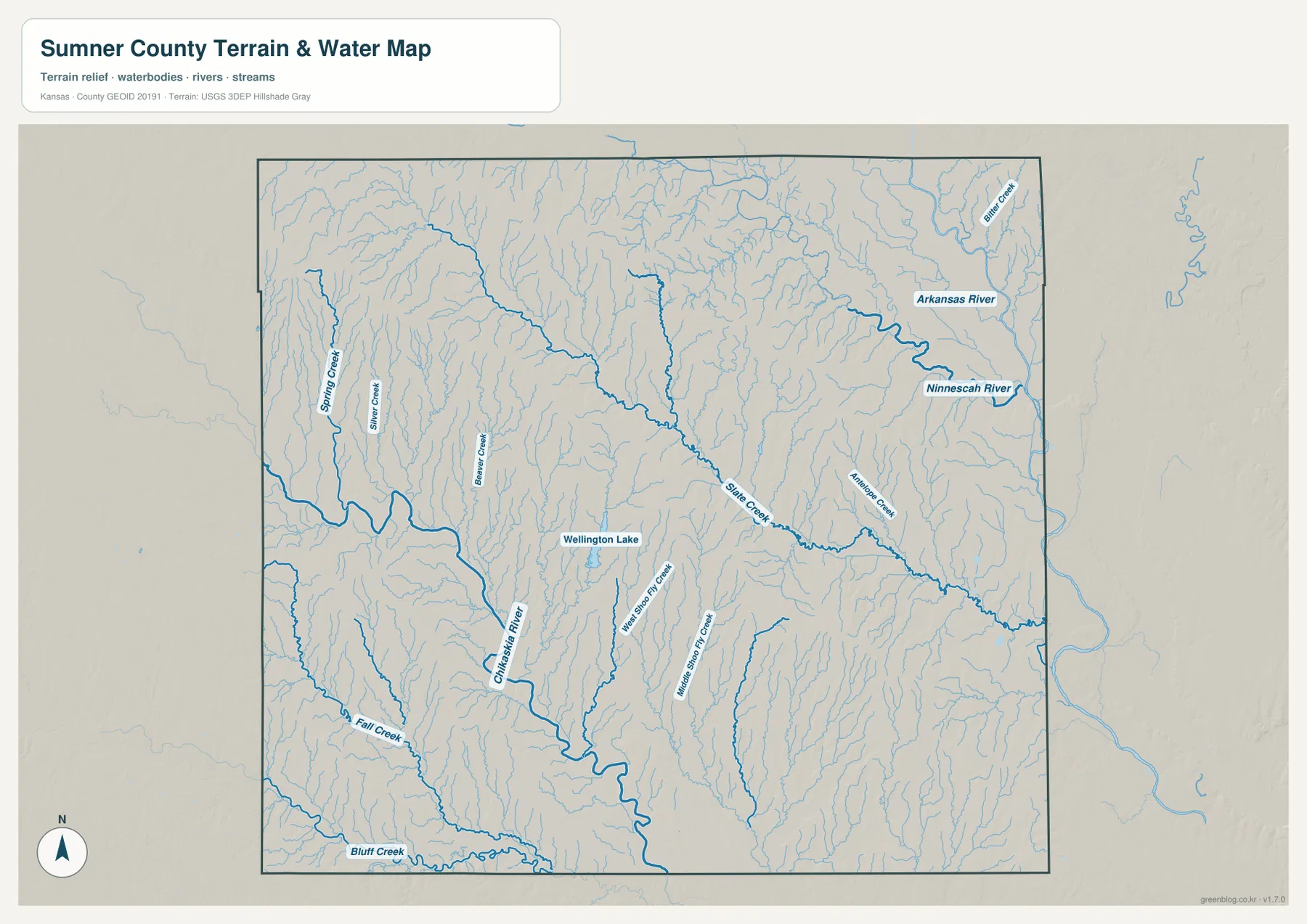
Slate Creek crosses the central-eastern portion of the county, and Antelope Creek contributes another long drainage line on the east. Fall Creek and Bluff Creek appear in the southwest. The pattern contrasts narrow tributary valleys in the west with broader river lowlands toward the east and south.
This water image is intended for geographic reference rather than floodplain, navigation, water-quality, parcel, or legal-access decisions. River and lake conditions can change, so current agency information should be used whenever safety or property decisions are involved.
Elevation from 317 to 460 meters falls from the northwest toward the river valleys
The elevation surface ranges from about 317 to 460 meters, with a mean near 374 meters. Brown and tan high ground is concentrated in the northwest, while greener low terrain becomes more extensive through the central, eastern, and southern river corridors.
The Conway Springs–Argonia side contains some of the highest terrain in the county, dissected by Spring Creek and other narrow tributaries. Around Wellington the land surface is lower, and toward Oxford and the eastern rivers the valleys broaden considerably.
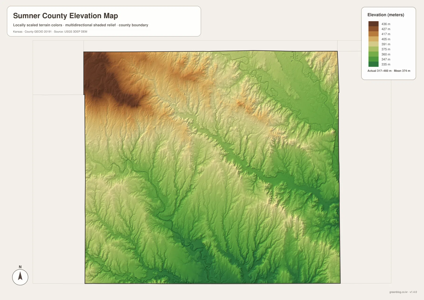
The Chikaskia River forms a long green low corridor through the south-central county, while southeastern tributaries cut deeply into surrounding hills. The northeast also descends toward the Arkansas River system but remains broken by ridges and smaller creek valleys rather than becoming completely flat.
The elevation surface is generalized for county-scale comparison. It is not survey-grade or engineering-grade measurement and should not be used for parcel elevations, construction grades, drainage design, or legal boundary work.
Caldwell preserves one of the county’s strongest Chisholm Trail connections
The Kansas Historical Society notes that the Chisholm Trail passed through Sumner County and that Caldwell became an important cattle-trail town near the Kansas–Oklahoma line. A state historical marker south of Caldwell identifies this area as the place where the trail entered Kansas during the era of major Texas cattle drives.
Caldwell is modest on the modern city index, but its location still makes sense as a historic gateway. The town sits near the southern edge of the county, where north–south travel routes crossed open prairie before continuing toward the rail markets farther north.
Wellington Lake provides a major recreation and water landmark west of the city
The City of Wellington places Wellington Lake about six miles west of town on US 160 and four miles south on Anson Road. The official lake page lists approximately 674 acres of water and about 10 miles of shoreline, with fishing, boating, camping, and other recreational uses.
On the county water map, Wellington Lake stands out as a clear named water body between Wellington and the western rural area. It is much smaller than the county’s major river systems, but it provides an easy real-world reference when comparing roads, drainage, and local recreation west of the county seat.
The Wellington–Caldwell corridor links the county seat with the southern border country
Following US 81 south from Wellington quickly leaves the urban street grid and enters a landscape of farms, creek crossings, and low rolling terrain. Near Caldwell, the Oklahoma line and the Chikaskia drainage become stronger references, giving the southern end of the route a very different setting from the county seat.
Traveling west toward Argonia instead moves into higher ground cut by Spring Creek, while east toward Oxford brings the route closer to the Arkansas and Ninnescah lowlands. Comparing these directions across the road, water, and elevation views shows that Sumner County is more varied than a simple plains map suggests.
For posters, classroom prints, or presentation slides, use the original JPG files in the download archive rather than enlarging the web previews. Small road labels, creek names, community text, and the elevation legend remain clearer at the higher resolution.
Frequently Asked Questions
Which city is largest on the supplied city index?
Wellington ranks first at 7,615. Conway Springs is 1,573, Belle Plaine 1,494, Caldwell 977, Oxford 964, and Argonia 542. These are map index values rather than current official population estimates.
Where is the Chisholm Trail associated with Sumner County?
The strongest local connection is around Caldwell near the Oklahoma line. Kansas historical markers describe this area as the place where the Chisholm Trail entered Kansas during the major cattle-drive era.
Can the 317–460 meter elevation image be used for surveying?
No. It is a generalized county-scale terrain image for comparing the higher northwest with lower river and creek valleys. Parcel elevations, engineering grades, drainage design, and legal boundary work require more precise official data and, where needed, professional surveying.
Map File Information
The archive contains the Sumner County, Kansas general county map, city map, terrain-and-water map, and elevation map as original high-resolution JPG files.
- Included Files: Use only the versions confirmed in the article and supplied images
- File Type: Use the confirmed download contents
- Intended Use: Printing, education, presentations, and map-based projects
Related Maps
Sources and references
- Kansas Historical Society: Sumner County, Kansas — county seat, Chisholm Trail, and local history
- Kansas Historical Society: Kansas Historical Markers — Caldwell and Chisholm Trail marker information
- City of Wellington: Lake Recreation — Wellington Lake location, size, and recreation information
- City of Wellington: Community Profile — Wellington and Sumner County community information
- U.S. Census Bureau TIGER/Line Shapefiles — county boundary and geographic reference data
- USGS 3D Elevation Program — elevation and terrain reference data
Green Map creates custom-edited map images using open geographic data sources such as geoBoundaries, Natural Earth, OpenStreetMap, and government open data. These maps are edited visual materials, not raw data files, and are provided for education, documents, presentations, and graphic reference.