Sheridan County lies in northwestern Kansas, where Hoxie serves as the county seat and Selden provides a second small settlement reference in the northwest. The county looks simple on a road map, but its terrain is strongly divided by the North Fork and South Fork of the Solomon River and by the Saline River system farther south. High plains in the west descend toward increasingly deep and broad stream valleys in the east. High-resolution map files are available for download in the section below.
This guide follows Hoxie, Selden, US 24, US 83, K-23, the Solomon River forks, the Saline River drainage, and terrain ranging from about 722 to 915 meters. WebP previews are available for quick viewing, and the matching high-resolution JPG files can be downloaded together in one ZIP for printing, classroom work, or offline reference.
Table of Contents
Hoxie anchors the county at the US 24 and K-23 crossroads
Hoxie sits near the center of Sheridan County, with US 24 crossing east–west and K-23 providing a strong north–south reference. Rail lines and local roads also concentrate around the town. Because the rest of the county is sparsely settled, this crossroads provides the easiest starting point for locating farms, stream valleys, and smaller communities.
Sheridan County’s official website identifies Hoxie as the county seat, and the city page describes its location at the highway crossroads. The Kansas Historical Society also lists Hoxie as the county seat. The modern map therefore matches the county’s administrative pattern: the courthouse, transportation routes, and largest settlement all occupy the same central area.
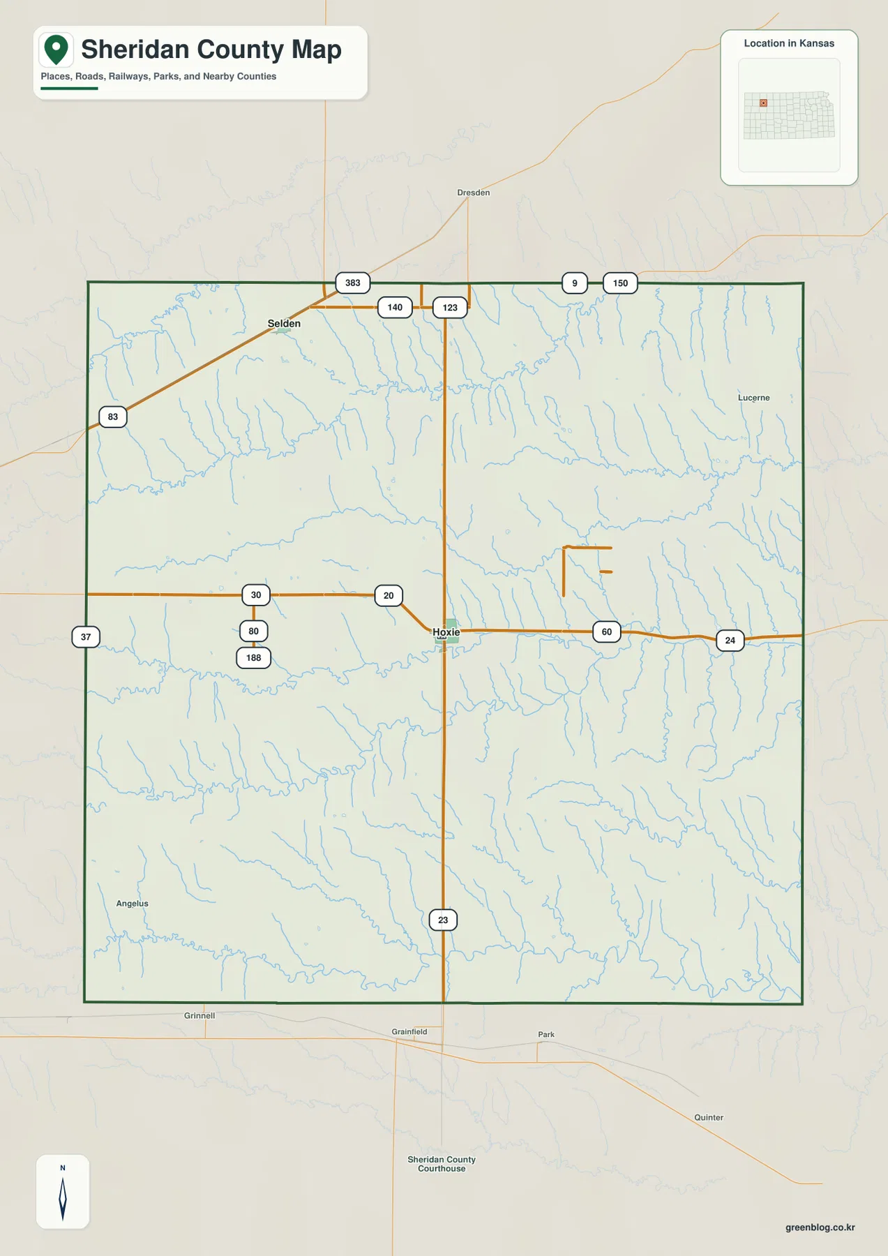
Selden lies in the northwestern part of the county along the US 83 corridor. The official Selden page also notes the railroad that parallels the highway. Between Selden and Hoxie, urban development is limited, so drainage lines and gradual elevation changes become more useful geographic references than a chain of towns.
The ranked city panel contains only Hoxie and Selden
The supplied city index lists Hoxie at 1,042 and Selden at 288. These are map index values rather than current official population estimates. The difference shows Hoxie’s stronger local role, but the more important geographic point is that the two ranked communities occupy different parts of the county.
Hoxie is tied to the central US 24 and K-23 corridors, while Selden is associated with the northwestern US 83 route. Large areas between them contain farms, minor place names, and stream-cut terrain rather than continuous development.
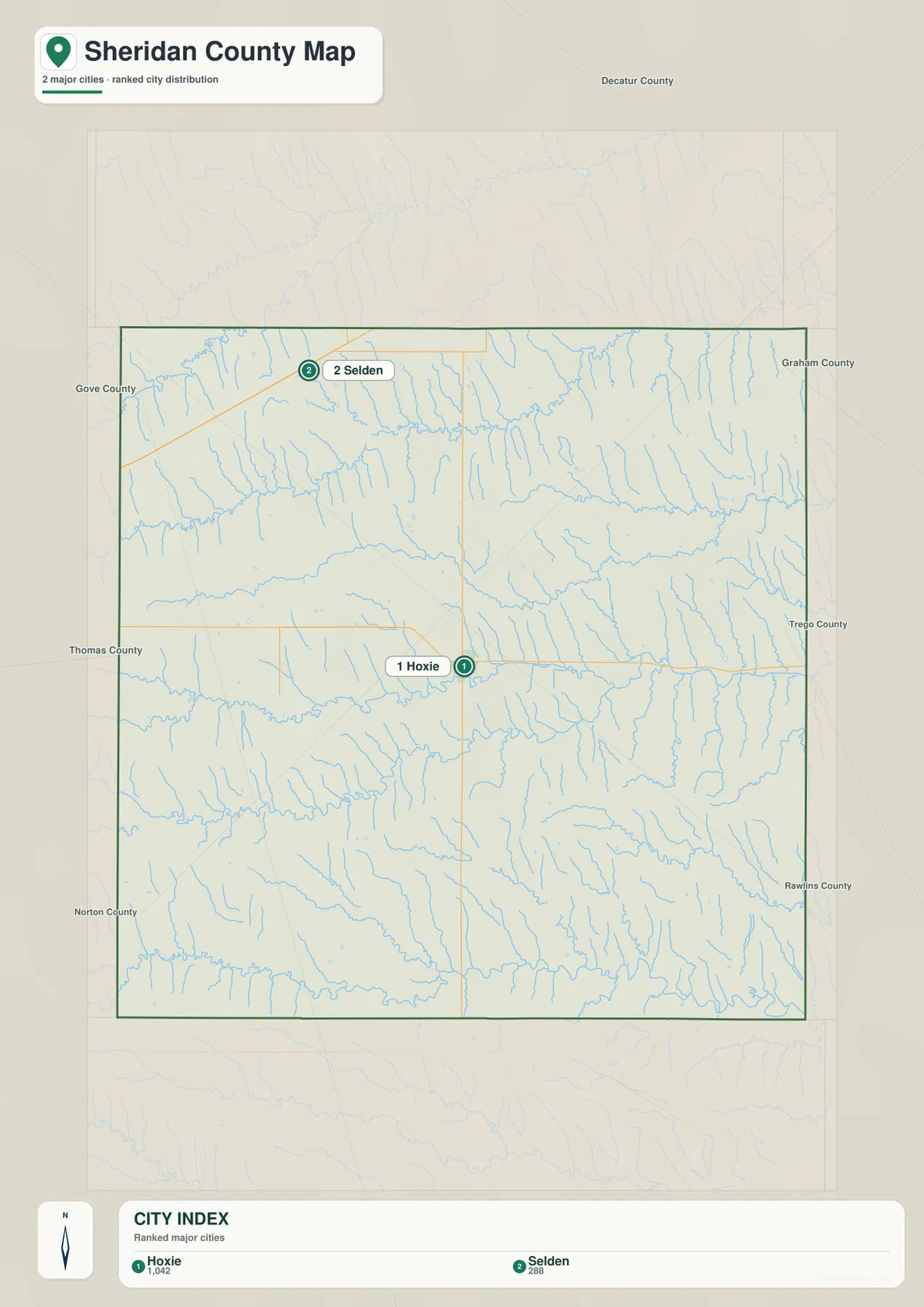
The county’s official website also recognizes smaller communities such as Angelus, Seguin, and Studley, but they are not part of the supplied ranked-city panel. Their presence on other maps or local directories should not be confused with additional city-index values.
The two Solomon River forks create the county’s most important interior valleys
The North Fork Solomon River crosses the northern part of Sheridan County and forms one of the clearest low corridors on the terrain map. Numerous short tributaries descend from the surrounding High Plains, producing a deeply dissected landscape that is easy to miss on the general road view.
South Bow Creek occupies another long valley between the northern and southern Solomon systems. Bow Creek, Antelope Creek, and North Creek are especially noticeable in the eastern half, where closely spaced drainage lines cut the uplands into narrow ridges.
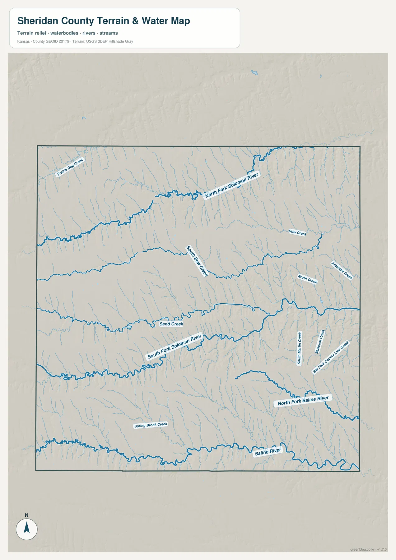
The South Fork Solomon River crosses the south-central part of the county, with Sand Creek running nearby through another broad east–west valley. Farther southeast, the North Fork Saline River and additional creeks lead toward the Saline River, which follows the southern part of the mapped area.
Sheridan County therefore has no single river corridor that explains the entire landscape. Instead, parallel east–west valleys divide the county into several upland belts. This pattern becomes especially clear when the water map is compared with the elevation surface.
The water image is intended for geographic reference rather than floodplain, navigation, water-quality, parcel, or legal-access decisions. Stream conditions can change with weather and season, so current agency information should be used whenever access or safety matters.
Elevation from 722 to 915 meters falls sharply from western uplands toward the east
The elevation surface ranges from about 722 to 915 meters, with a mean near 836 meters. Brown and tan high ground dominates the west and northwest, while greener lower terrain becomes more extensive toward the east. Nearly 200 meters of local relief separates the highest uplands from the lowest valley floors.
The difference is not a smooth west-to-east slope. The North Fork Solomon River, South Fork Solomon River, Saline River, and many tributaries cut deep green corridors into the higher surface. In the west, those valleys are narrow and steep-sided; farther east, lower ground becomes broader and more connected.
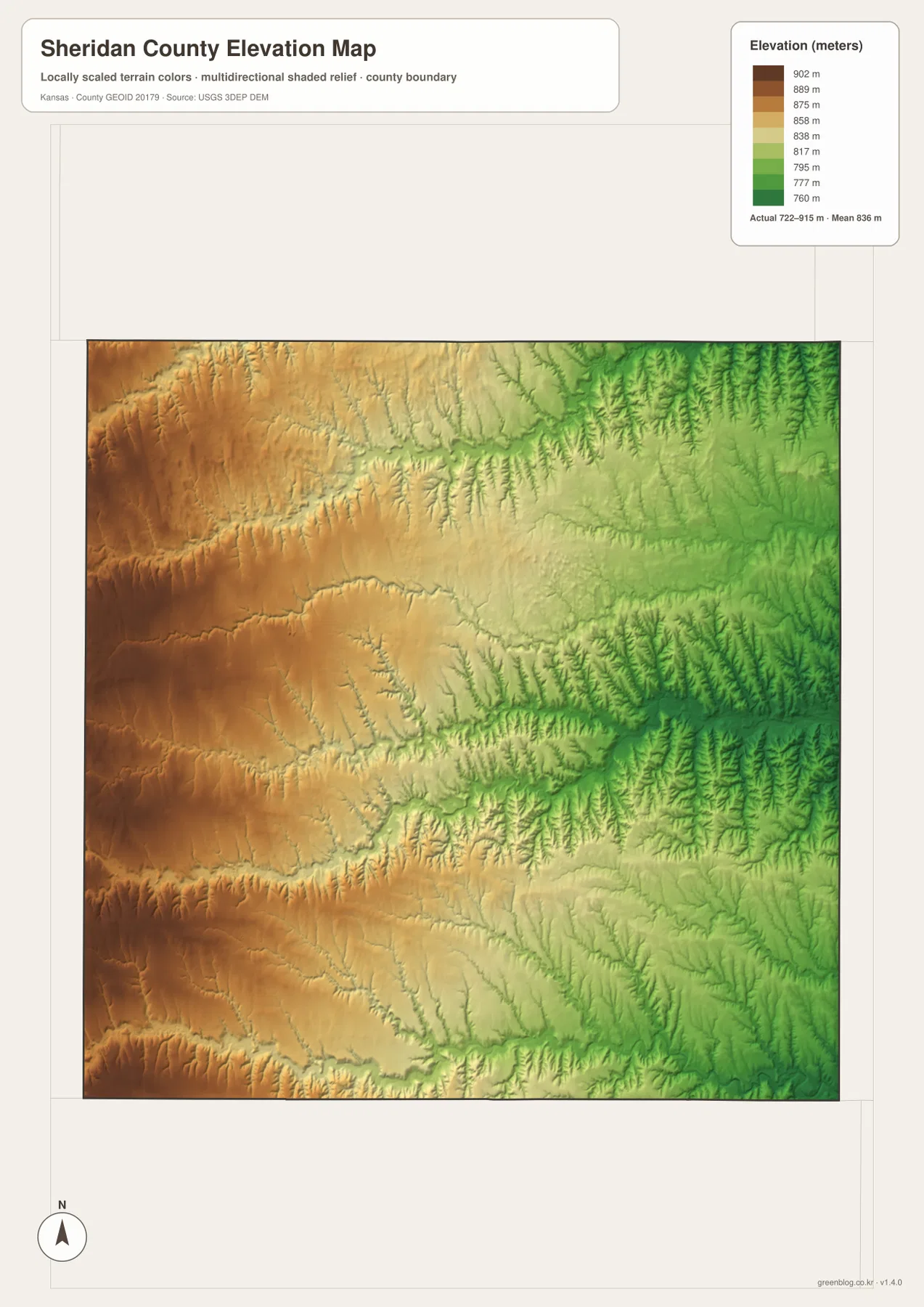
Hoxie occupies middle-elevation terrain near the center of the county, while Selden lies closer to the higher northwestern plain. The eastern boundary contains some of the broadest lower terrain because several tributaries have already joined the main river systems by that point.
The elevation surface is generalized for county-scale comparison. It is not survey-grade or engineering-grade measurement and should not be used for parcel elevations, construction grades, drainage design, or legal boundary work.
Cottonwood Ranch links Studley with Sheridan County’s English settlement history
Cottonwood Ranch State Historic Site stands near Studley on the eastern side of Sheridan County. The Kansas Historical Society explains that the Pratt family came from Yorkshire, England, and established a sheep ranch on the High Plains in the late nineteenth century. Native stone buildings and Yorkshire-influenced architectural details preserve a distinctive chapter of western Kansas settlement.
The official county site places Studley on the Sheridan–Graham county line and identifies Cottonwood Ranch just west of the community. On the county map this is a small eastern place name, but the historic site gives the area a much stronger identity and helps connect the eastern lowland landscape with actual settlement history.
Sheridan State Fishing Lake provides a local outdoor reference east of Hoxie
Sheridan County visitor information and the Kansas Department of Wildlife and Parks place Sheridan State Fishing Lake roughly eleven to twelve miles east of Hoxie. The site occupies prairie and cropland country and includes a state-managed lake and wildlife area used for camping, picnicking, and other outdoor visits.
Lake conditions and fishing opportunities can change during management or renovation work, so anyone planning a fishing trip should check the current KDWP notice before leaving. For geographic orientation, however, the lake is a useful landmark for the rural US 24 corridor east of Hoxie.
Routes from Hoxie reveal three different versions of the High Plains
Travel northwest toward Selden and the land rises toward the higher plateau around US 83. Follow US 24 east toward Studley and the terrain gradually drops into broader Solomon River drainage country. Head south on K-23 and the road crosses the upland belts between the South Fork Solomon and Saline river systems.
These changes are why Sheridan County benefits from comparing road, water, and elevation views together. A straight highway may cross several creek valleys and nearly two hundred meters of county-wide relief, even though the general map initially appears open and simple.
For posters, classroom prints, or presentation slides, use the original JPG files in the download archive rather than enlarging the web previews. Small road labels, creek names, place names, and the elevation legend remain clearer at the higher resolution.
Frequently Asked Questions
Why does the ranked city map show only Hoxie and Selden?
The supplied city-index dataset contains two ranked entries for Sheridan County: Hoxie at 1,042 and Selden at 288. Smaller communities can still appear on the general map or county directories, but they are not additional ranked-city values in this package.
What is the strongest terrain pattern in Sheridan County?
The clearest pattern is the drop from higher western and northwestern High Plains into lower river valleys toward the east. The North Fork and South Fork Solomon rivers create especially strong green corridors on the 722–915 meter elevation image.
Can the elevation image be used for surveying or engineering?
No. It is a generalized county-scale terrain image for comparing high plains with lower river and creek valleys. Parcel elevations, engineering grades, drainage design, and legal boundary work require more precise official data and, where needed, professional surveying.
Map File Information
The archive contains the Sheridan County, Kansas general county map, city map, terrain-and-water map, and elevation map as original high-resolution JPG files.
- Included Files: Use only the versions confirmed in the article and supplied images
- File Type: Use the confirmed download contents
- Intended Use: Printing, education, presentations, and map-based projects
Related Maps
Sources and references
- Sheridan County, Kansas official website — county seat and county overview
- City of Hoxie official page — Hoxie road connections and community information
- Kansas Historical Society: Sheridan County, Kansas — county establishment, county seat, and history
- Kansas Historical Society: Cottonwood Ranch — Studley-area English sheep-ranch history
- Kansas Department of Wildlife and Parks: Sheridan State Fishing Lake — lake and recreation information east of Hoxie
- USGS 3D Elevation Program — elevation and terrain reference data
Green Map creates custom-edited map images using open geographic data sources such as geoBoundaries, Natural Earth, OpenStreetMap, and government open data. These maps are edited visual materials, not raw data files, and are provided for education, documents, presentations, and graphic reference.