Osage County lies south of Topeka in eastern Kansas, where US 75 provides the strongest north–south reference through the middle of the county. Osage City is the largest marker on the supplied city index, Lyndon is the county government center, and Carbondale, Overbrook, Burlingame, and Scranton form a second group of towns farther north. Two large reservoirs—Pomona and Melvern—sit in separate drainage valleys and make water a major part of the county’s geography. High-resolution map files are available for download in the section below.
This guide follows those towns, highways, reservoirs, and stream valleys across an elevation range of roughly 275 to 397 meters. WebP previews are available in the article, and the matching high-resolution JPG files can be downloaded together in one ZIP for printing, classroom work, or offline reference.
Table of Contents
US 75 ties Carbondale, the central county, and Lyndon together
US 75 is the easiest road to find on the general county map. It runs south from the Carbondale area, passes near Scranton, and continues through the Lyndon area toward the southern part of Osage County. US 56 and K-31 provide additional references across the northern tier, while Overbrook lies farther east on a separate corridor.
Osage City sits west of US 75 in the central-western part of the county and connects with K-170 and local roads. Burlingame is farther north, while Lyndon occupies a more central position near US 75. Osage County’s official government address is in Lyndon, so the road map and the administrative center align well.
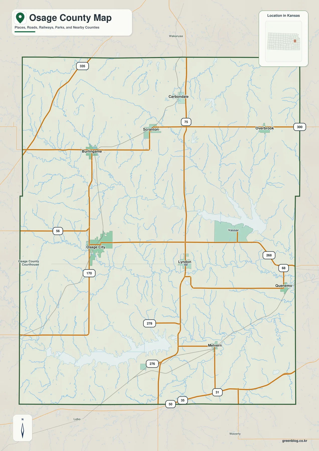
K-268 and K-68 become more important toward the Pomona Reservoir and Quenemo side of the county. Melvern is farther south near the lake that shares its name. The towns are separated by broad rural areas and creek valleys rather than forming one continuous built-up corridor.
Osage City leads the six-city index, with several northern towns close behind
The city-distribution panel lists Osage City at 2,828, Carbondale at 1,341, Overbrook at 1,113, Burlingame at 1,046, Lyndon at 1,023, and Scranton at 911. These are map index values rather than current official population estimates, but they explain the relative size of the markers on the supplied city map.
The settlement pattern is split between two broad areas. Osage City and Lyndon provide the strongest references in the central and southern interior, while Carbondale, Scranton, Overbrook, and Burlingame are clustered more toward the northern half. Looking at the road map beside the city panel shows why the northern communities depend on several different east–west routes rather than one single corridor.
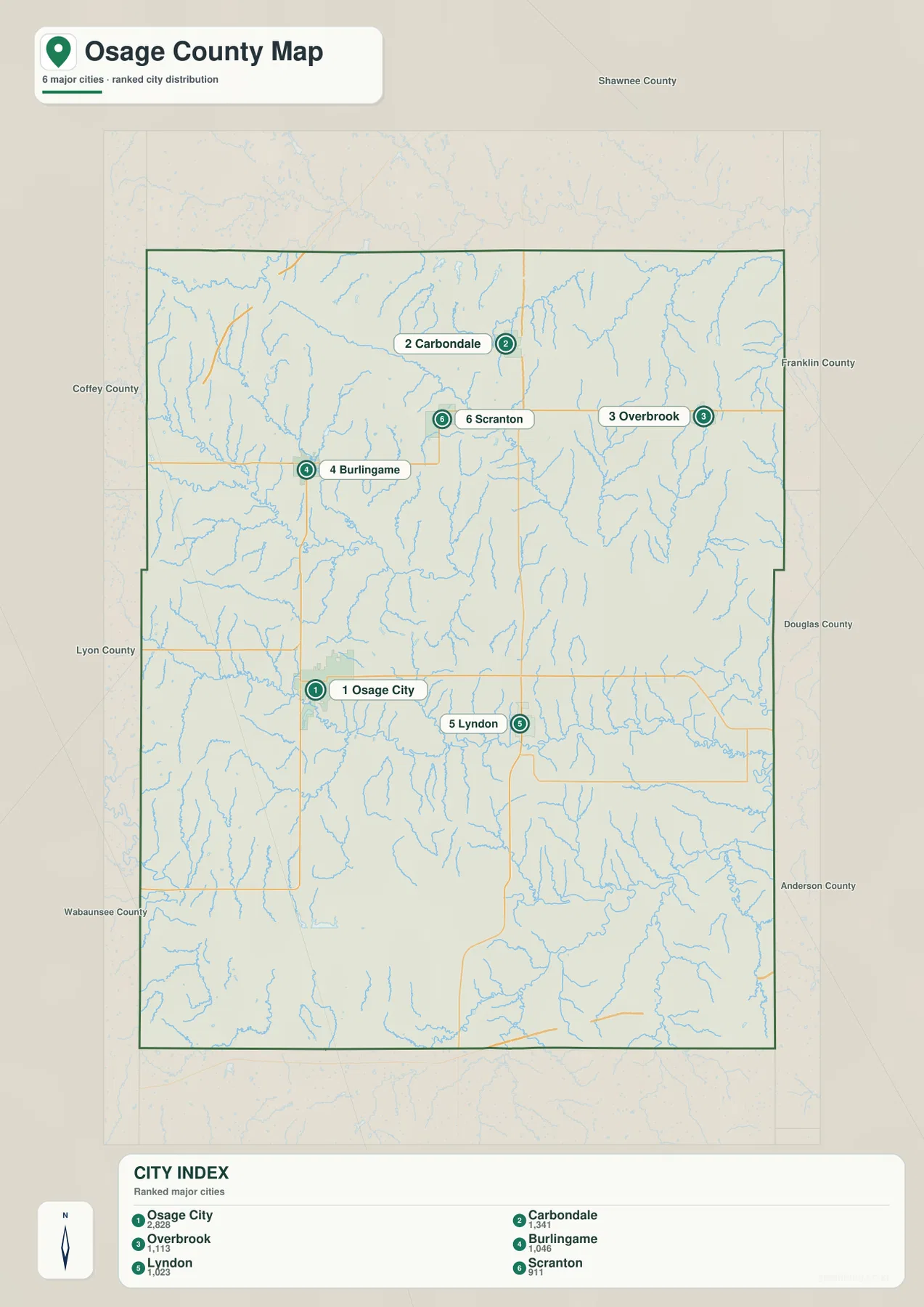
Lyndon’s role is different from its position in the city ranking. Although it is fifth on the supplied index, it serves as the county government center. Osage City remains the largest city marker and a strong western reference, so using both towns together gives a more complete picture of the county.
Pomona Reservoir and Melvern Lake define two major water landscapes
Pomona Reservoir is the dominant water feature in the northeastern part of the county. Hundred and Ten Mile Creek feeds the reservoir, and Wolf Creek and smaller tributaries cut the surrounding hills. Kansas Department of Wildlife and Parks places Pomona State Park on the south shore of the reservoir in Osage County.
Melvern Lake occupies a separate valley in the southern county. The Marais des Cygnes River continues eastward from the lake system, creating a long low corridor across the southern landscape. Kansas Department of Wildlife and Parks identifies Eisenhower State Park on the north shore of Melvern Lake, also within Osage County.
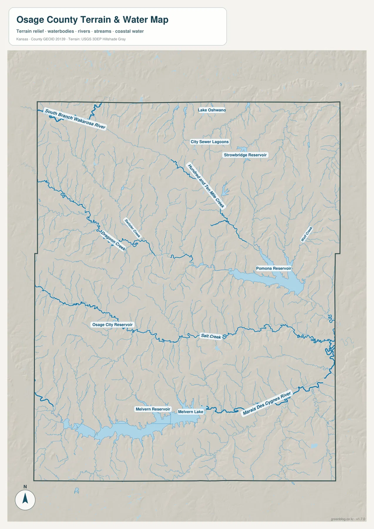
Between the two large reservoirs, Salt Creek crosses the middle of the county and creates another long valley. Dragoon Creek and the South Branch Wakarusa River cut through the northern terrain, while Osage City Reservoir provides a smaller local water landmark near the western-central part of the county.
This water image is intended for geographic reference rather than floodplain, navigation, water-quality, parcel, or legal-access decisions. Stream depth, reservoir level, and recreation rules can change, so current agency information should be used whenever access or safety matters.
Relief from 275 to 397 meters highlights western hills and lower reservoir valleys
The elevation surface ranges from about 275 to 397 meters, with a mean near 332 meters. Higher brown and tan ridges are especially prominent in the west and northwest, while broad green lowlands follow the major creeks, reservoirs, and rivers toward the center and east.
Pomona Reservoir sits in a wide lower valley fed by numerous tributaries. Melvern Lake and the Marais des Cygnes River create another large low corridor across the south, while Salt Creek forms a central green band. These valleys repeatedly divide higher ridges, so the county is more rolling than the road map alone suggests.
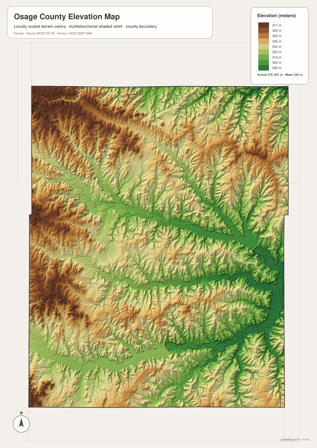
Northern Osage County is also strongly dissected by streams. The South Branch Wakarusa River and Dragoon Creek cut narrow green valleys through higher ground, and the eastern side contains many closely spaced tributaries. The southeast drops toward the Marais des Cygnes system, creating one of the lowest continuous areas on the map.
The elevation surface is generalized for county-scale comparison. It is not survey-grade or engineering-grade measurement and should not be used for parcel elevations, construction grades, drainage design, or legal boundary work.
Pomona State Park sits where prairie and eastern woodland meet
Kansas Department of Wildlife and Parks describes Pomona State Park as a 490-acre park on the south shore of Pomona Reservoir in Osage County. The official page notes that the park lies in a transition zone between prairie and eastern woodland and provides boating, fishing, camping, hiking, and other recreation.
K-268 and nearby roads make the reservoir area easy to locate from the general county map. On the elevation image, the reservoir occupies a broad low basin surrounded by higher ridges, which makes the northeastern part of the county look very different from the rolling uplands farther west.
Eisenhower State Park and Melvern Lake mark the eastern edge of the Flint Hills
Eisenhower State Park sits on the north shore of Melvern Lake in Osage County. Kansas Department of Wildlife and Parks describes the area as part of the eastern fringe of the Flint Hills, with tallgrass prairie, woodland, and extensive access to the lake.
The physical maps show that setting clearly. Melvern Lake fills a long valley, the Marais des Cygnes River continues downstream, and higher ridges rise on both sides. The southern county therefore combines open uplands with a broad river-and-reservoir corridor rather than one uniform plain.
Following Osage City to Lyndon and then toward the reservoirs connects the layers
Start with Osage City and Lyndon on the road map to understand the central county. The same area on the water image adds Salt Creek and its tributaries, and the elevation image shows why those channels occupy lower ground between surrounding ridges.
The same approach works around Pomona Reservoir or Melvern Lake. Locate the water body, trace the creeks or river entering and leaving it, and then compare the green lowland with the higher terrain nearby. Following a real place from one image to another is more useful than memorizing a list of map categories.
For posters, classroom prints, or presentation slides, use the original JPG files in the download archive rather than enlarging the web previews. Small road numbers, creek labels, town names, and the elevation legend remain clearer at the higher resolution.
Frequently Asked Questions
Which city is largest on the supplied city index?
Osage City ranks first at 2,828. Carbondale is 1,341, Overbrook 1,113, Burlingame 1,046, Lyndon 1,023, and Scranton 911. These are map index values rather than current official population estimates.
Are Pomona Reservoir and Melvern Lake in the same part of the county?
No. Pomona Reservoir is in the northeastern part of Osage County, while Melvern Lake is in the south. Both occupy broad low valleys, but they connect to different roads, towns, and drainage systems.
Can the 275–397 meter elevation image be used for surveying?
No. It is a generalized county-scale terrain image for comparing higher ridges with lower creek, river, and reservoir valleys. Parcel elevations, engineering grades, drainage design, and legal boundary work require more precise official data and, where needed, professional surveying.
Map File Information
The archive contains the Osage County, Kansas general county map, city map, terrain-and-water map, and elevation map as original high-resolution JPG files.
- Included Files: Use only the versions confirmed in the article and supplied images
- File Type: Use the confirmed download contents
- Intended Use: Printing, education, presentations, and map-based projects
Related Maps
Sources and references
- Osage County, Kansas official website — county government and Lyndon location information
- Kansas Department of Wildlife and Parks: Pomona State Park — Pomona Reservoir, park location, and recreation context
- Kansas Department of Wildlife and Parks: Eisenhower State Park — Melvern Lake, eastern Flint Hills, and park information
- U.S. Census Bureau TIGER/Line Shapefiles — county boundary and geographic reference data
- USGS National Hydrography — river and stream reference data
- USGS 3D Elevation Program — elevation and terrain reference data
Green Map creates custom-edited map images using open geographic data sources such as geoBoundaries, Natural Earth, OpenStreetMap, and government open data.
These maps are edited visual materials, not raw data files, and are provided for education, documents, presentations, and graphic reference.