Morris County sits in the Flint Hills of east-central Kansas, but its geography is easiest to understand from two towns that are far apart: Council Grove in the east-central part of the county and Herington on the west. White City and Dwight lie farther north, while Wilsey and Latimer occupy smaller positions to the south and west. Council Grove Lake and the Neosho River add a strong physical reference that ties the road map to the rolling Flint Hills landscape.
This guide uses the supplied road, city, water, and elevation maps to explain those relationships without turning the page into a technical report. The WebP images are convenient for online viewing, and the original high-resolution JPG files are available together in a ZIP for printing, classroom use, or offline reference. The most useful contrast is between the higher western and northern hills and the lower lake-and-river corridor around Council Grove.
Table of Contents
Council Grove makes the road network easy to orient
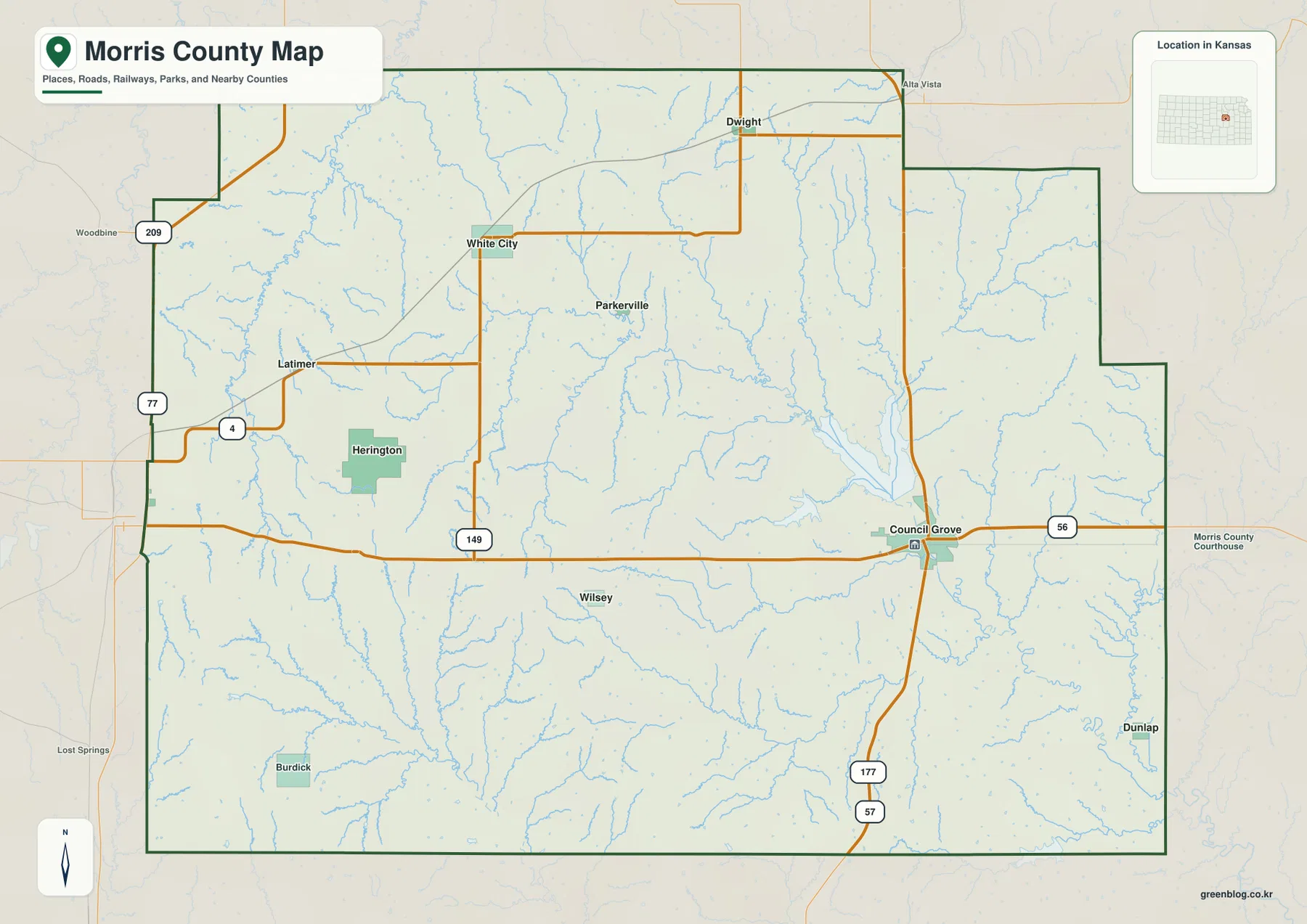
US 56 crosses Council Grove from west to east, while K-177 runs north–south through the same area. Those two routes make the city the simplest starting point for the county map. Travel west from Council Grove and the map opens toward Herington; follow K-177 north and Dwight becomes the next clear town reference. The large lake immediately north of the city provides an equally memorable physical landmark.
Herington belongs to a different road setting near K-4 and the US 77 corridor along the western side. White City is north-central, Wilsey is farther south, and Latimer is west of the county center. Because the towns are widely spaced, it is more useful to think of Council Grove and Herington as two separate anchors than to imagine one continuous settlement strip.
Neighboring counties reinforce the regional setting. Geary County is to the north, Wabaunsee and Lyon counties lie to the east, Chase and Marion counties are to the south and southwest, and Dickinson County is to the west. That position places Morris County squarely within the Flint Hills rather than on a broad western Kansas plain.
Two towns dominate the city ranking, but they sit on opposite sides of the county
The city index printed on the supplied map lists Council Grove at 2,265 and Herington at 2,164. White City follows at 458, Dwight at 242, Wilsey at 164, and Latimer at 84. These values are map index figures rather than current official population estimates, but they make the hierarchy clear: Council Grove and Herington are shown at nearly the same scale and are far more prominent than the other four communities.
The map also makes their spacing obvious. Council Grove is east-central, Herington is west, White City and Dwight are in the northern half, Wilsey lies to the south, and Latimer is in the west-central interior. That arrangement gives each part of the county a different nearest town and route reference.
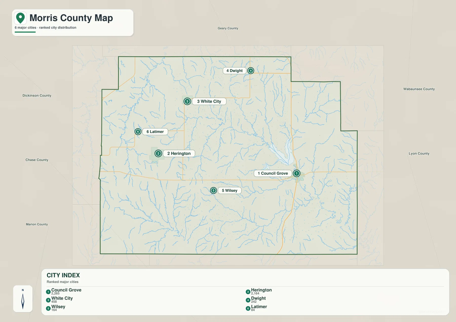
This simplified view is useful before opening the detailed road map. Once the general positions are clear, it becomes easier to connect Herington with the western highway corridor, Council Grove with US 56 and K-177, and the smaller northern and southern towns with their local roads.
Council Grove Lake gathers streams before the Neosho River continues southeast
Council Grove Lake is the largest water landmark in the county and sits immediately north of Council Grove. Several streams from the north and west feed the reservoir, and below the dam the Neosho River continues through the city area before bending toward the southeast. This lake-to-river sequence provides the clearest way to understand the eastern half of the county.
The West Fork Neosho River crosses the western and central interior. Slate Creek and Mulberry Creek are labeled in the northwest, Laird Creek and Slough Creek approach the lake, and Elm Creek and Fourmile Creek enter the southern drainage. Sixmile Creek forms another long valley farther southwest. The result is a branching network of narrow stream valleys feeding larger waterways.

A smaller City Reservoir is marked near Council Grove Lake, and part of Lake Kahola appears near the southeastern edge. Local visitor information distinguishes the federal Council Grove Lake from the smaller Council Grove City Lake, so the two names should not be treated as interchangeable when looking for access points or facilities.
This is a geographic water-reference map, not a floodplain, navigation, water-quality, or legal-boundary product. Stream flow and lake access can change, so current conditions should be checked with the appropriate managing agency before a visit.
The western Flint Hills stand well above the Neosho River corridor
Elevation ranges from about 352 to 476 meters, with a mean near 428 meters. Lower green terrain follows Council Grove Lake and the Neosho River through the east and southeast, while higher tan and brown ground covers much of the west, southwest, and north. The contrast is strong enough that the county’s rolling Flint Hills character is easy to see without contour lines.
Around Herington, the higher surface is cut by the West Fork Neosho River and several smaller streams. The north remains relatively high as well, but narrow valleys descend toward Council Grove Lake. East of the lake, the main Neosho River occupies a broader low corridor that opens toward the southeastern county boundary.
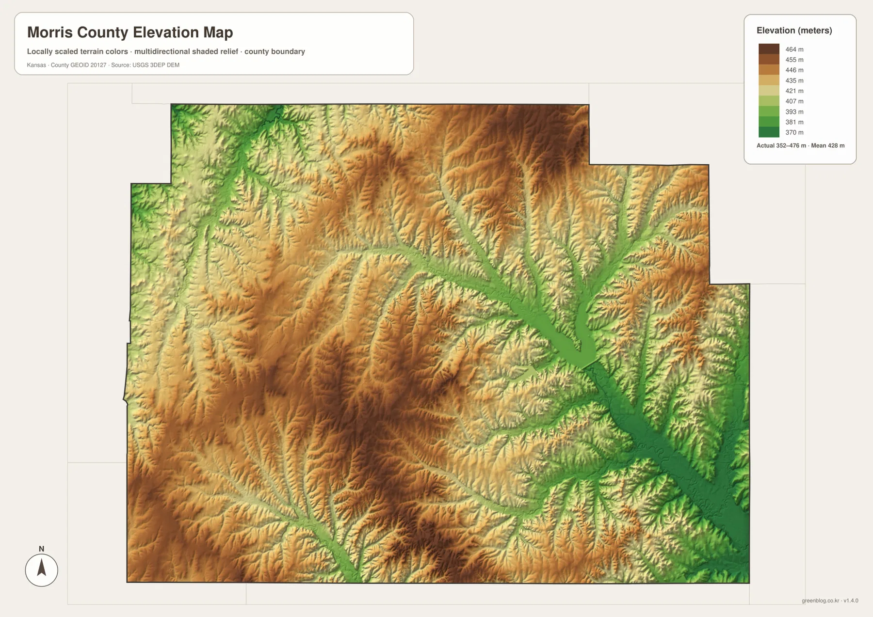
The water and elevation maps reinforce each other. Streams follow the green low strips between higher ridges, several of those valleys converge at Council Grove Lake, and the Neosho River then carries the low corridor southeast. This is especially clear when comparing the Herington side of the county with the broader land around Council Grove.
The elevation image is generalized for county-scale comparison. It should not be used for parcel elevations, construction grades, drainage design, or legal boundary work. Precise site decisions require more detailed official elevation data and, when appropriate, professional field surveying.
Council Grove Lake is both a landmark and a major recreation area
The lake north of Council Grove is more than a visual reference. The U.S. Army Corps of Engineers describes Council Grove Lake as a Flint Hills recreation destination with camping, swimming, boating, hiking, and fishing opportunities. Its location also explains why so many smaller streams in the northern and western part of the county appear to converge in the same area.
Destination: Council Grove also distinguishes the federal reservoir from the smaller Council Grove City Lake. Because the names are similar, visitors should confirm the exact lake before following directions or looking for a specific campground or boat ramp. The supplied water map shows the large reservoir and the smaller nearby water body separately.
Herington and Wilsey show the rougher western side of the county
The Herington side has a noticeably different landscape from the broad lower ground near Council Grove. Roads such as K-4 and US 77 cross higher rolling terrain, while the West Fork Neosho River, Slate Creek, and Mulberry Creek occupy narrow valleys between ridges. The elevation map shows frequent color changes here rather than one broad low plain.
Farther south toward Wilsey and Burdick, the same rolling pattern continues around Sixmile Creek and smaller tributaries. The terrain is not mountainous, but repeated rises and stream cuts give western and southern Morris County a more broken surface than the flatter-looking road grid might suggest.
Use each map for a different kind of question
The general map is the best starting point for Council Grove, Herington, White City, Dwight, US 56, K-177, and US 77. The city map removes most of the road detail and is better for comparing the six major communities and their spacing. The water map is the clearest choice for Council Grove Lake, the Neosho and West Fork Neosho rivers, and the named creeks.
The elevation layer is most useful when comparing the higher western Flint Hills with the lower lake and river valleys. Finding Council Grove and Herington on the road map first, then switching to elevation, makes the contrast between the two sides of the county easy to understand. Adding the water layer explains why many of the low strips follow named streams.
For posters, classroom prints, or presentation slides, use the original JPG files in the download archive rather than enlarging the WebP previews. The high-resolution files preserve small road shields, stream labels, town names, and the elevation legend more clearly.
Frequently Asked Questions
Are Council Grove Lake and Council Grove City Lake the same place?
No. Council Grove Lake is the large federal reservoir north of Council Grove on the Neosho River system. Council Grove City Lake is a separate, smaller water body nearby. Visitors looking for recreation facilities should confirm which lake they need before following directions.
Which side of Morris County is higher, Council Grove or Herington?
The Herington side is generally associated with higher western Flint Hills terrain, while Council Grove sits closer to the lower lake-and-river corridor. The elevation map makes the contrast especially easy to see.
Can the 352–476 meter elevation map be used for surveying?
No. It is a generalized county-scale surface for comparing hills and river valleys. Parcel elevations, engineering grades, drainage design, and legal boundary work require more precise official data and, where needed, professional surveying.
Map File Information
The archive contains the Morris County, Kansas general county map, city map, terrain-and-water map, and elevation map as original high-resolution JPG files.
- Included Files: Use only the versions confirmed in the article and supplied images
- File Type: Use the confirmed download contents
- Intended Use: Printing, education, presentations, and map-based projects
Related Maps
Sources and references
- Destination: Council Grove — Council Grove, Morris County, Flint Hills, lakes, and local visitor information
- U.S. Army Corps of Engineers: Council Grove Lake — reservoir location, management, and recreation information
- U.S. Census Bureau TIGER/Line Shapefiles — county boundary and geographic reference data
- USGS National Hydrography — river and stream reference data
- USGS 3D Elevation Program — elevation and terrain reference data
Green Map creates custom-edited map images using open geographic data sources such as geoBoundaries, Natural Earth, OpenStreetMap, and government open data.
These maps are edited visual materials, not raw data files, and are provided for education, documents, presentations, and graphic reference.