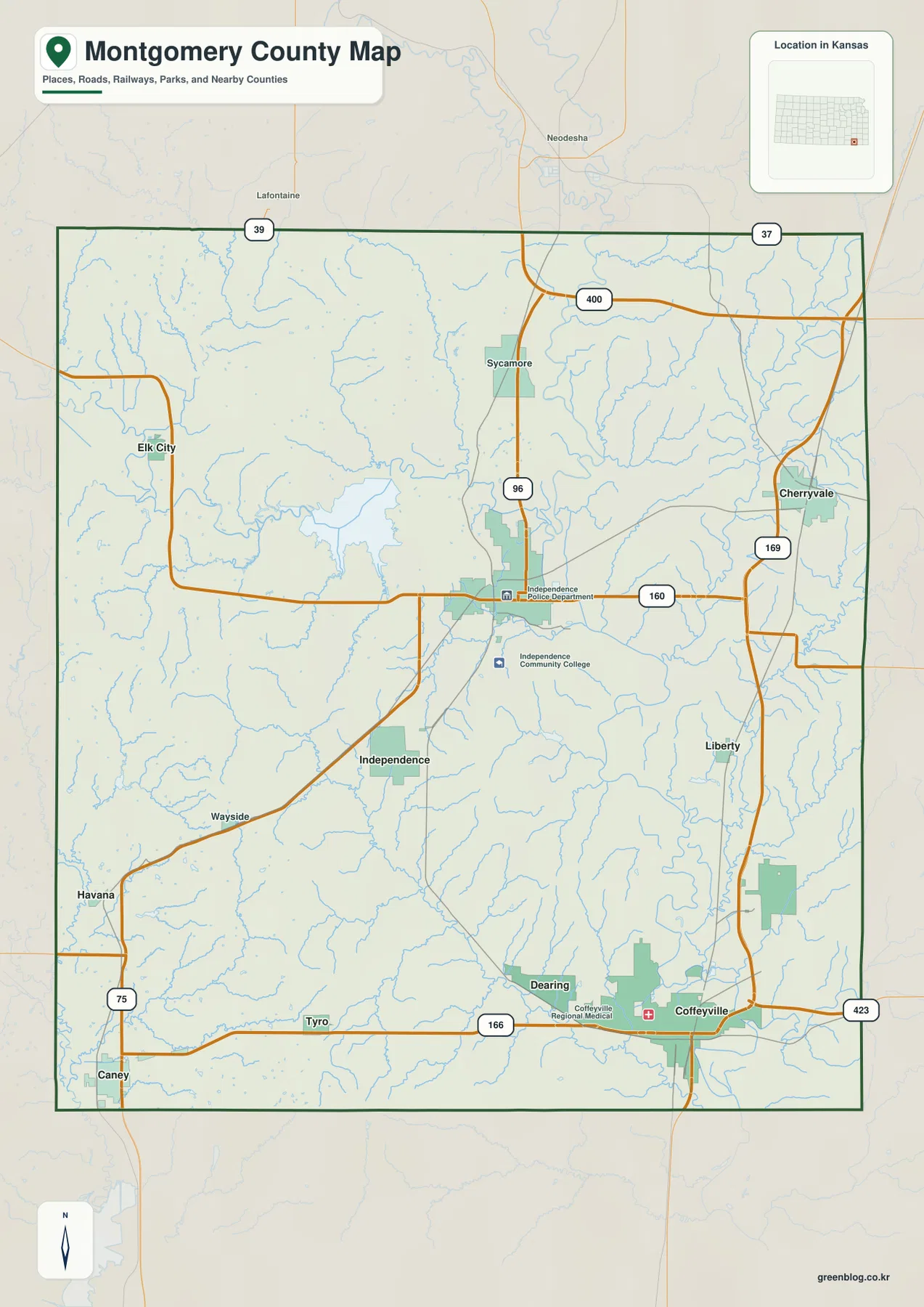
Montgomery County in southeastern Kansas is easiest to orient from two cities that sit in very different parts of the county: Independence near the center and Coffeyville in the southeast. Cherryvale is farther northeast, Caney anchors the southwest, Elk City lies northwest of Independence, and Dearing sits close to Coffeyville. The road map gives a quick overview, but the county becomes much more distinctive when Elk City Lake, the Verdigris River, and the rolling western hills are added to the picture.
This guide uses the supplied county, city, water, and elevation maps to explain those relationships in plain geographic terms. The WebP images work well for online viewing, and the original high-resolution JPG files are available together in a ZIP for printing, classroom materials, or offline reference. The four layers are particularly useful for comparing the rugged Elk City Lake area with the broader lowlands around the Verdigris River.
Table of Contents
Start in Independence, then split the county into northwest, northeast, and southeast routes
Independence is a practical starting point because US 160 crosses the city and several roads branch away from it. Traveling northwest leads toward Elk City and the reservoir country, while the eastern side reaches the US 169 corridor and Cherryvale. Coffeyville is farther southeast, and Caney occupies a separate southwestern route near US 75. This arrangement gives Montgomery County several distinct travel directions instead of one continuous urban strip.
Coffeyville is the strongest city presence in the southeast and connects westward along K-166 toward Dearing and Tyro. Cherryvale is separated from both large cities in the northeast, while Sycamore appears north of Independence. When these places are viewed together, the county map works less like a single city-region map and more like a set of connected town areas separated by farms, streams, and low ridges.
County labels around the edge add useful regional context. Labette County lies to the east, Wilson County to the north, and Chautauqua County is toward the west. These labels are not driving directions, but they help explain why Cherryvale and Coffeyville sit close to the county’s eastern side while Caney and Elk City belong to the western half.
The city map shows two large centers and four much smaller communities
The printed city index on the supplied map lists Coffeyville at 8,662 and Independence at 8,422. Cherryvale follows at 2,096, Caney at 1,431, Dearing at 279, and Elk City at 245. These figures are map index values rather than a replacement for current official population estimates, but they make the visual hierarchy easy to understand: Coffeyville and Independence dominate the map, while the remaining four communities are much smaller.
Their spacing matters just as much as their ranking. Independence is close to the middle, Coffeyville is well to the southeast, Cherryvale occupies the northeast, and Caney sits near the southwest boundary. Elk City is in the northwest and Dearing is close to Coffeyville, so each part of the county has a different nearest town and road reference.
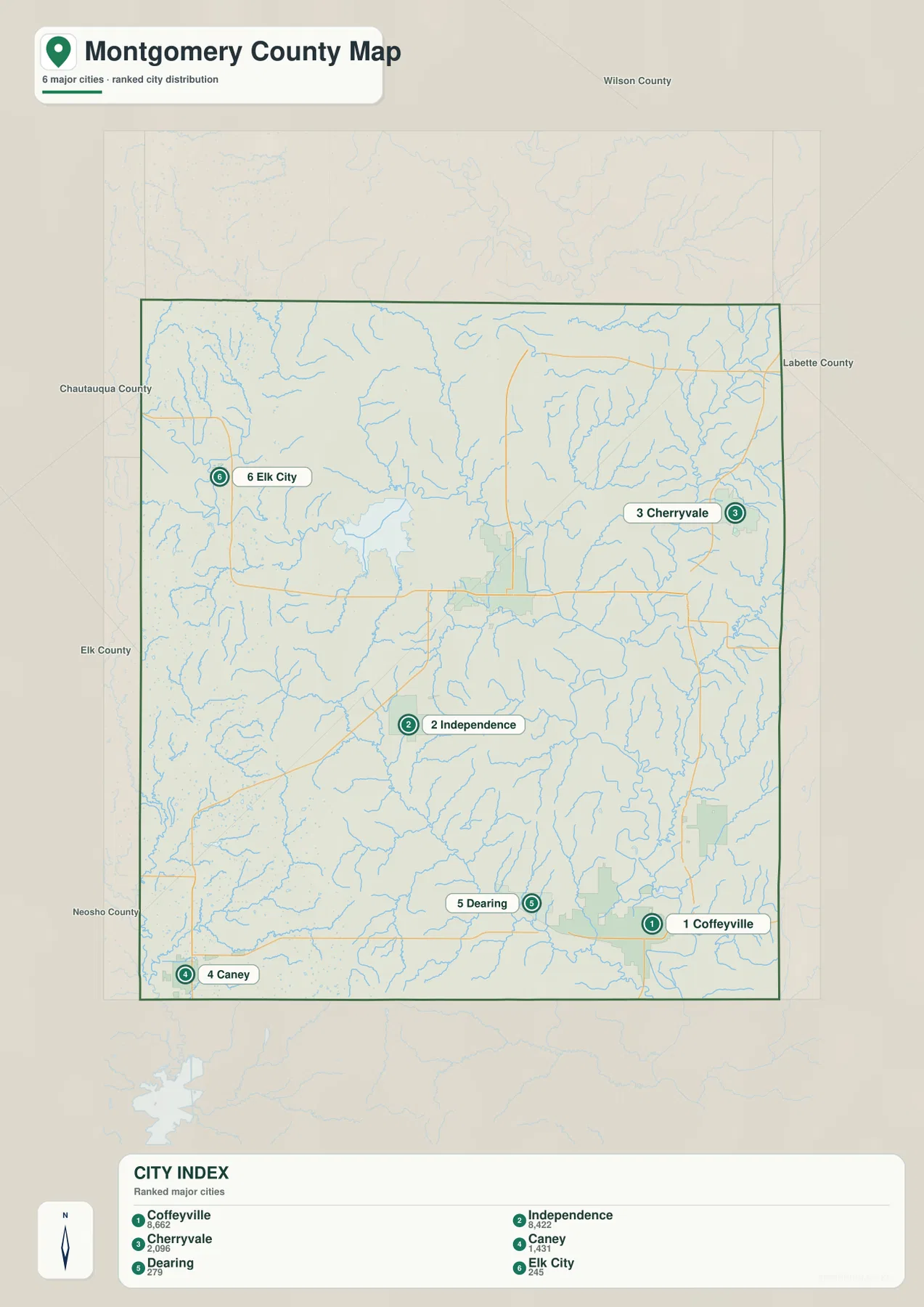
This simplified layer is useful before opening the more detailed road map. A reader looking for Elk City can immediately focus on the northwest, while someone heading to Caney knows to look toward the southwest. The large gap between Independence and Coffeyville also becomes obvious without highway symbols or water features competing for attention.
Elk City Lake occupies a narrow river valley in the higher northwest
Elk City Lake is the clearest water landmark in northwestern Montgomery County. The Elk River approaches from the west, winds through a confined valley, and broadens into the reservoir northwest of Independence. Kansas Department of Wildlife and Parks places Elk City State Park on the east side of the lake and describes a landscape of grasslands, woodlands, limestone bluffs, and trails.
That setting is easy to recognize on the map because the lake is surrounded by visibly broken terrain. The Elk River and its tributaries cut between higher ridges before the water widens into the reservoir. Compared with the broad southeastern lowlands, the lake area feels tighter and more rugged even at county-map scale.
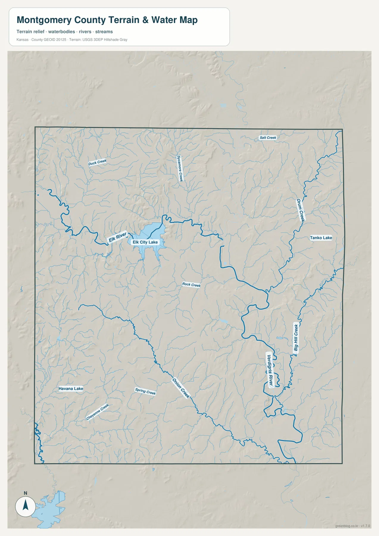
The Verdigris River becomes the main water feature farther east and south. Big Hill Creek and Drum Creek join the larger lowland, while Rock Creek crosses the interior and Onion Creek and Spring Creek appear in the south and southwest. Duck Creek, Sycamore Creek, and Salt Creek add more branching valleys in the northern half.
Smaller waters such as Tanko Lake and Havana Lake are also labeled. This layer is intended for locating rivers, creeks, and lakes; it does not provide flood-zone boundaries, current depth, water quality, property lines, or recreation status. Those details should be checked with the appropriate agency when they matter.
The elevation map separates the western hills from the Verdigris lowlands
Elevation ranges from about 207 to 337 meters, with a mean close to 253 meters. The highest broad areas are in the west and northwest, where brown and dark tan colors cover many ridges. Lower green terrain spreads across the center, east, and southeast, especially along the Verdigris River and its major tributaries.
The northwest stands out because the Elk River has cut a distinct valley through higher ground. Around Elk City Lake, ridges rise close to the water, creating more abrupt local changes than in the broad river flats farther east. Independence sits in a more moderate part of the county, while Coffeyville is associated with a much wider lowland.
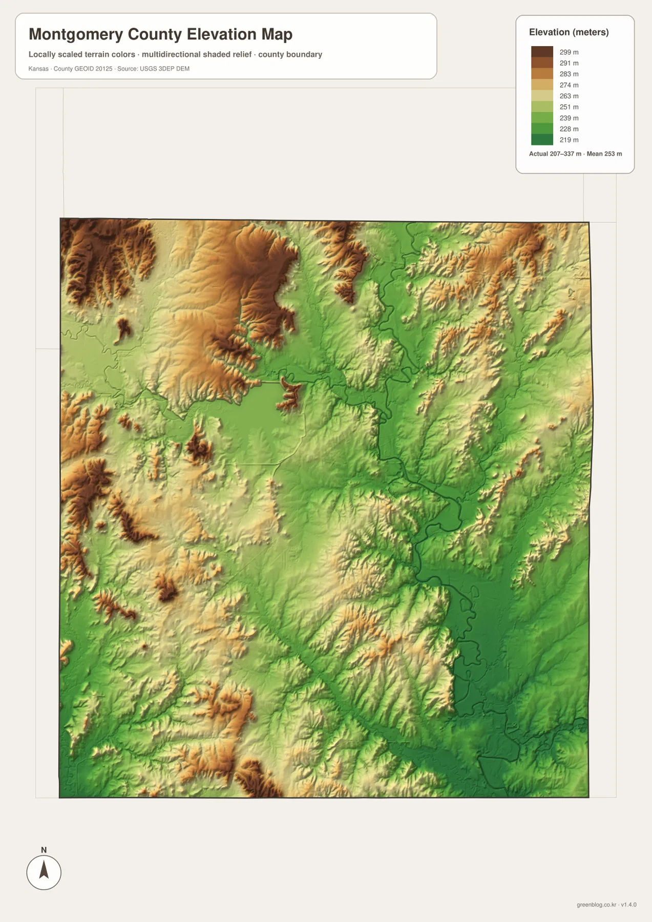
Many of the green bands on the elevation map match named waterways on the water map. Big Hill Creek and Drum Creek occupy lower paths in the east, and the Verdigris River forms a long low corridor near Coffeyville. Small tributaries cut narrow green fingers into the western hills, explaining why the county is rolling rather than uniformly flat.
This surface is intended for county-scale terrain comparison. It is not survey-grade information for a parcel, building site, drainage design, or legal boundary. Precise site work requires detailed official elevation data and, when necessary, professional field surveying.
Elk City Lake and Coffeyville show the county’s strongest physical contrast
The northwest reservoir country and the southeastern city lowlands provide an easy way to understand the county’s physical range. Around Elk City Lake, water occupies a confined valley bordered by higher ridges. Near Coffeyville, the Verdigris River and Big Hill Creek spread across a much broader low area, and the elevation colors remain greener over a larger region.
The difference also changes what each map layer contributes. Around Elk City Lake, the water and elevation maps explain the rugged setting better than the city map alone. Around Coffeyville, the road map adds K-166 and nearby communities, while the physical maps explain why the city lies close to a wide river corridor.
Coffeyville’s road connections sit beside the county’s broadest low terrain
Coffeyville is the largest city in the supplied index and occupies the southeastern corner of the county’s main populated area. K-166 runs west toward Dearing and Tyro, while US 169 provides a major north–south reference nearby. The Verdigris River and Big Hill Creek are close enough that the city’s setting makes more sense when roads and waterways are viewed together.
Although this part of the county is low, it is not completely level. River bends, tributaries, and small ridges break the surface into smaller pieces. The elevation map therefore shows a broad green region with subtle changes rather than one flat block of color.
Frequently Asked Questions
Are Independence and Coffeyville close together on the county map?
They are separated by a substantial part of the county. Independence is near the center, while Coffeyville is in the southeast. The general map is useful for understanding the direction between them, but current navigation should be used for exact road distance and travel time.
What is the easiest landmark for finding Elk City Lake?
Independence is the simplest city reference. Elk City Lake is northwest of Independence, and the Elk River enters the reservoir from the west. Kansas Department of Wildlife and Parks and the U.S. Army Corps of Engineers both describe the lake as a major recreation area northwest of the city.
Can the 207–337 meter elevation map be used for surveying?
No. It is a generalized county-scale terrain image for comparing uplands and river valleys. Parcel elevations, engineering grades, drainage design, and legal boundary work require more precise official data and, where appropriate, professional surveying.
Map File Information
Download the map files associated with this page for reference, printing, and compatible visual projects.
- Included Files: Use only the versions confirmed in the article and supplied images
- File Type: Use the confirmed download contents
- Intended Use: Printing, education, presentations, and map-based projects
Related Maps
Sources and references
- Montgomery County, Kansas official website — county government and local information
- Kansas Department of Wildlife and Parks: Elk City State Park — Elk City Lake, trails, and surrounding landscape
- U.S. Army Corps of Engineers: Elk City Lake — reservoir location and management information
- U.S. Census Bureau TIGER/Line Shapefiles — county boundary and geographic reference data
- USGS National Hydrography — river and stream reference data
- USGS 3D Elevation Program — elevation and terrain reference data
Green Map creates custom-edited map images using open geographic data sources such as geoBoundaries, Natural Earth, OpenStreetMap, and government open data.
These maps are edited visual materials, not raw data files, and are provided for education, documents, presentations, and graphic reference.