Jewell County lies along the Nebraska border in north-central Kansas, where Mankato is the county seat and the largest city shown on the map. Jewell, Randall, Burr Oak, Formoso, and Esbon provide smaller settlement anchors across a strongly rural landscape. K-36 crosses the middle of the county, while K-14, K-112, K-128, and K-78 connect the north-south road network. High-resolution JPG versions of the map set can be downloaded together from the ZIP box below. High-resolution map files are available for download in the section below.
The county’s strongest natural feature is Lovewell Reservoir on White Rock Creek. The creek runs across the northern part of Jewell County before entering the reservoir, while Limestone Creek and its branches cut deeply into the southwest. West Marsh Creek, East Marsh Creek, Buffalo Creek, and Spring Creek create lower drainage corridors farther east. Elevation ranges from about 425 to 601 meters with a mean near 506 meters, showing higher western terrain and lower eastern country.
The Kansas Historical Society places Jewell County in the Smoky Hills and records Mankato as the county seat since 1873. The U.S. Bureau of Reclamation operates Lovewell Dam on White Rock Creek as part of the Bostwick Division, linking the reservoir to irrigation and flood-control systems in the Republican River basin. These local features make Jewell County more distinctive than its regular rural road grid first suggests.
Table of Contents
Mankato and K-36 provide the quickest county orientation
Mankato sits slightly east of the county center and is the best place to begin on the general map. K-36 crosses the city from west to east, connecting the Esbon and Formoso sides of the county. K-14 extends south toward Jewell, K-112 serves the western interior near Esbon, and K-128 runs south through the Ionia area. K-78 provides another north-south reference toward Burr Oak.
Burr Oak lies in the northwest, Esbon in the western interior, Formoso to the east of Mankato, and Jewell in the south-central county. Randall sits farther southeast, while Webber provides a northeastern reference near the Lovewell Reservoir country. Together these places form a simple set of anchors for a county with large stretches of farmland between towns.
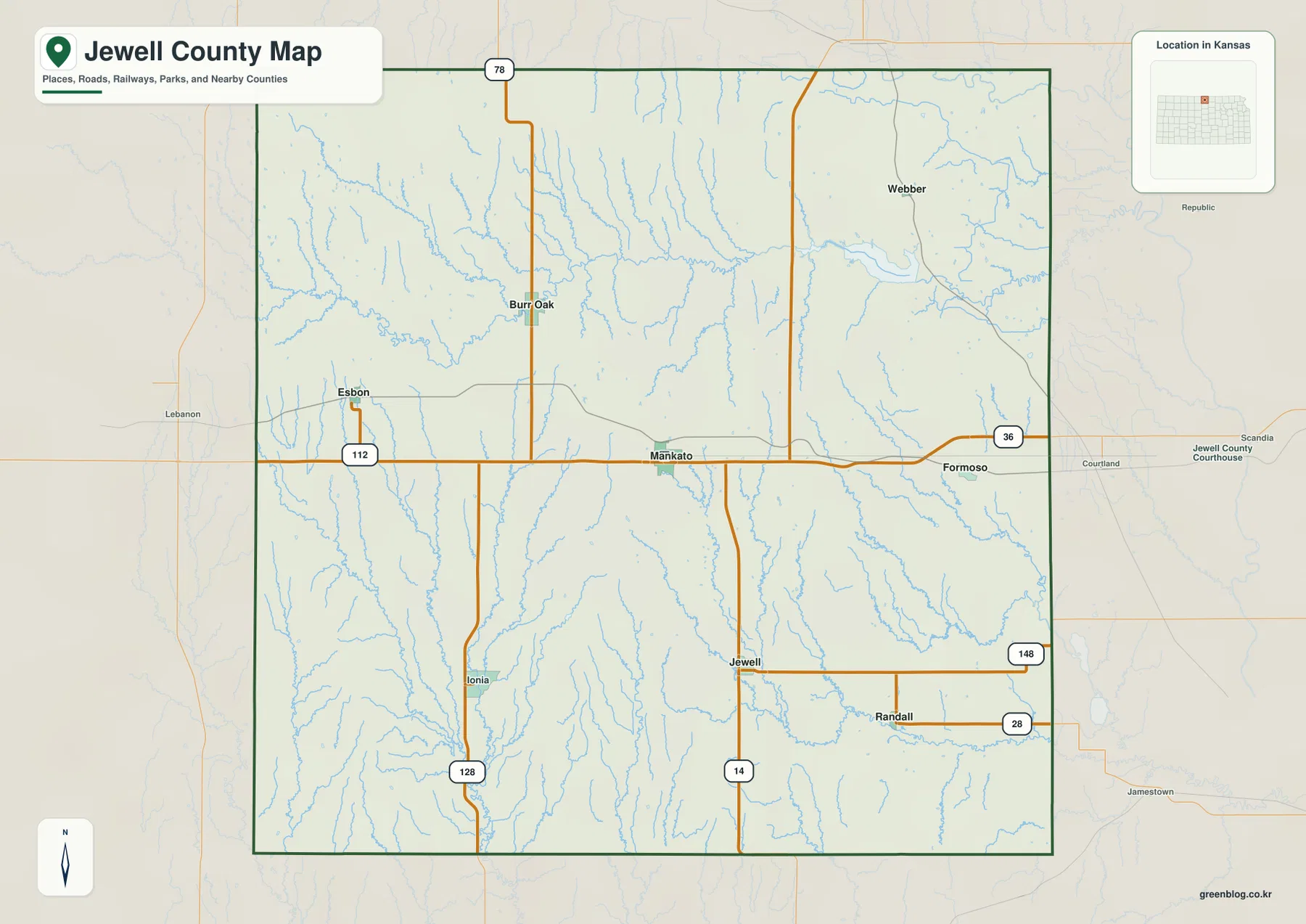
The road grid is fairly regular across the farming areas, but it becomes less uniform near White Rock Creek, Limestone Creek, and the reservoir. Bridges and valley crossings force local roads to bend or stop, especially in the north and southwest. This map is intended for county-scale orientation rather than live navigation, so current construction, winter weather, and unpaved-road conditions should be checked separately.
Mankato leads a small six-city settlement pattern
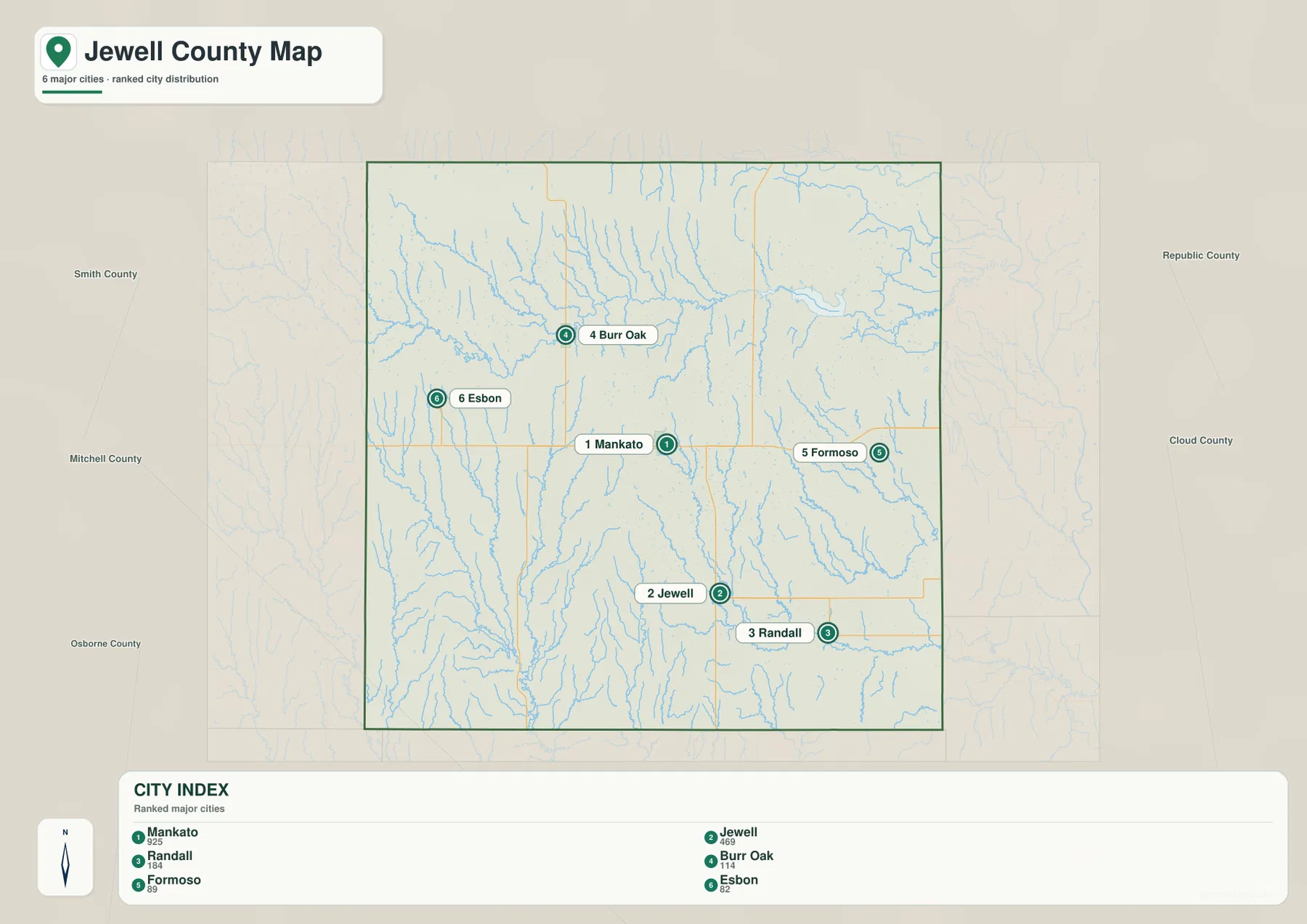
The city distribution map ranks Mankato first, Jewell second, Randall third, Burr Oak fourth, Formoso fifth, and Esbon sixth. The displayed values are 925 for Mankato, 469 for Jewell, 184 for Randall, 114 for Burr Oak, 89 for Formoso, and 82 for Esbon. Those numbers reflect the source used to create the map and may differ from later estimates.
Mankato concentrates county government and local services, while Jewell is the strongest southern community. Randall marks the southeast, Burr Oak the northwest, Esbon the west, and Formoso the east. Because the county contains few sizable towns, these six labels provide nearly all of the settlement references needed to understand the road map.
The Kansas Historical Society explains that Jewell City was the original county seat when the county was organized in 1870. An 1873 election moved the seat to Jewell Center, which later became Mankato. The modern map therefore reflects a nineteenth-century shift in political geography that placed the county’s administrative center near its middle.
White Rock Creek feeds Lovewell Reservoir across the north
White Rock Creek is the most prominent stream on the terrain map. It enters from the west, crosses the northern county, and flows into Lovewell Reservoir. Bitter Creek joins the northern drainage network, and many short tributaries descend into the White Rock valley from the higher uplands.
Lovewell Reservoir is an engineered part of that natural system. U.S. Bureau of Reclamation records show that Lovewell Dam was constructed from 1955 to 1957 on White Rock Creek. The reservoir regulates water from the creek and also receives diverted water from the Republican River through the Courtland Canal, connecting Jewell County to a much larger irrigation system.
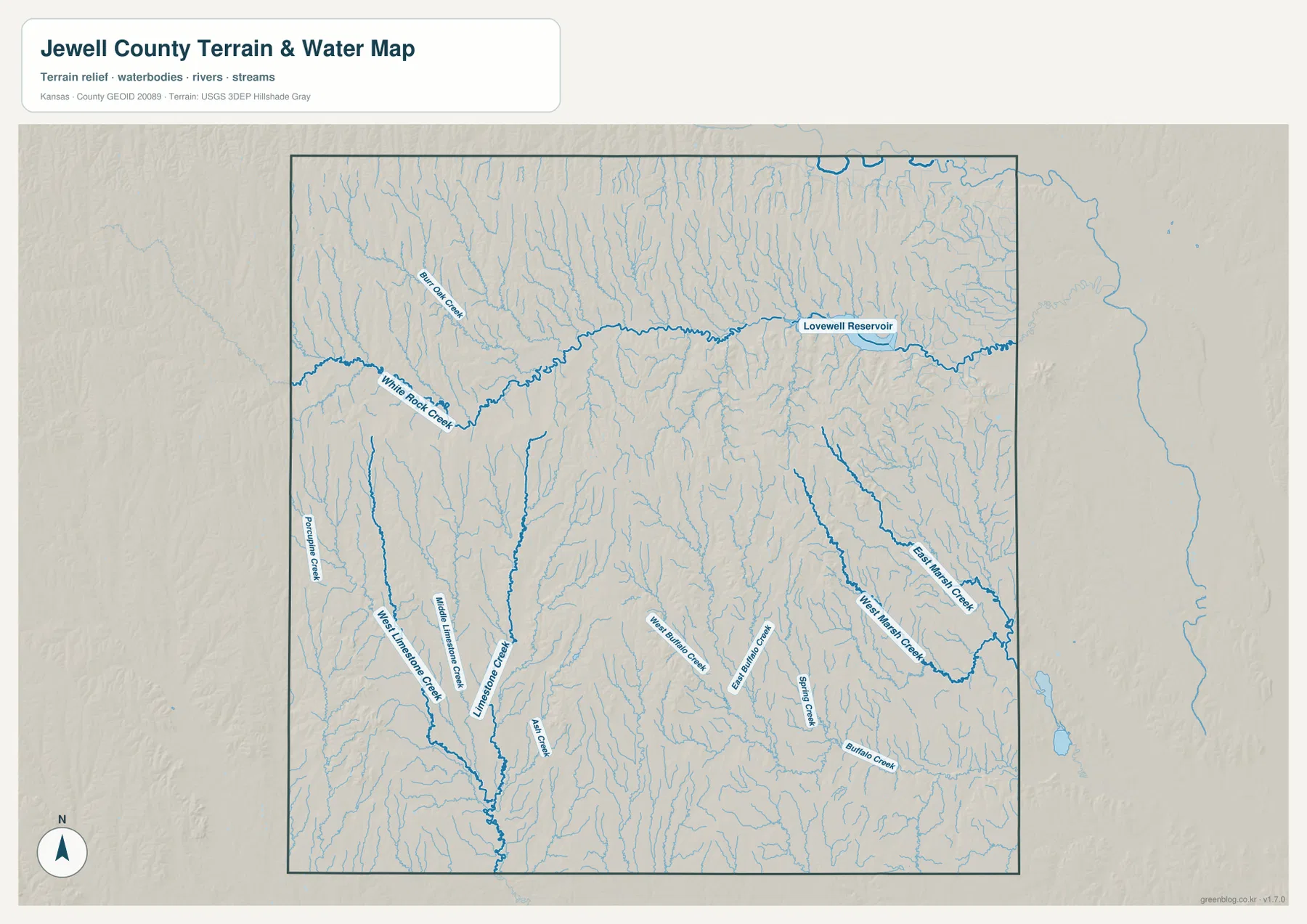
The southwest contains the long Limestone Creek drainage, including West Limestone Creek, Middle Limestone Creek, and Ash Creek. West Marsh Creek and East Marsh Creek cut across the eastern county, while Buffalo Creek and Spring Creek form additional low valleys in the southeast. The map shows geographic position rather than current streamflow, flood risk, or water quality.
Relief drops from 601-meter western uplands toward 425-meter eastern valleys
The elevation map shows an actual county range of approximately 425 to 601 meters and a mean elevation near 506 meters. Brown and dark tan colors dominate much of the west and northwest, with another high ridge running through the central-southern county. Moving east, the colors become progressively greener, indicating lower terrain.
The White Rock Creek–Lovewell Reservoir corridor forms a broad low band across the north. Limestone Creek cuts deep green valleys into the high southwest, while the Marsh and Buffalo Creek systems occupy lower eastern country. The contrast gives Jewell County a rolling, dissected appearance rather than the completely flat surface often associated with the central Great Plains.
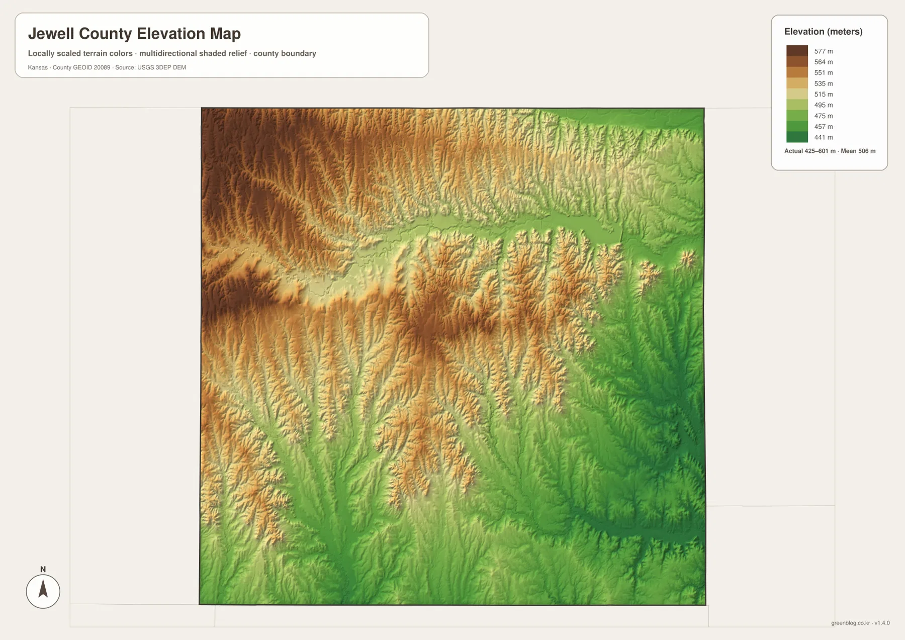
This elevation surface is intended for county-scale comparison rather than survey-grade measurement. It should not be used to establish exact parcel elevations, design drainage, or replace engineering and legal survey data. Its main value is showing the county-wide transition from higher western ground to lower eastern drainage country.
Lovewell Reservoir connects local geography with regional water management
Lovewell Reservoir is more than a large lake on the map. The U.S. Bureau of Reclamation operates it as part of the Bostwick Division, where stored water supports irrigation and contributes to flood control, wildlife habitat, and recreation. The reservoir therefore links Jewell County agriculture with the wider Republican River basin.
The shape of the reservoir also influences travel. Roads near Webber, Lovewell, and the northern county must work around long coves and stream valleys, unlike the straighter agricultural grid farther south. Comparing the general map with the terrain view makes the impact of the reservoir on local access much clearer.
Fishing, boating, camping, and other recreation are common around the reservoir, but water levels and facilities can vary. Visitors should check current Bureau of Reclamation or Kansas park information when planning access to the lake.
How Jewell Center became Mankato
Jewell County was organized in 1870 and named for Lieutenant Colonel Lewis F. Jewell, who died while serving with the Sixth Kansas Cavalry during the Civil War. Jewell City initially served as the county seat, but voters selected Jewell Center in 1873. Jewell Center later adopted the name Mankato.
The Kansas Historical Society also records the establishment of Fort Jewell in 1870 during a period of fear about possible attacks on settlers. The fort was not attacked, but its brief existence reflects the uncertainty of the county’s early settlement period.
The present Jewell County Courthouse in Mankato was built in 1936–1937. Its location reinforces the administrative role Mankato has held for more than a century, and the general map still shows the city in the most useful central position for county orientation.
Smoky Hills geology appears in fossils and deeply cut valleys
Kansas Geological Survey research gives Jewell County a distinctive geologic story. Much of the near-surface bedrock formed during the Cretaceous Period when the Western Interior Seaway covered the region. Marine fossils found in the county include shells and remains from animals that lived in that ancient sea.
Later deposits around the Lovewell Reservoir area preserve a different chapter. Geological work has documented mammoth remains and other Pleistocene fossils associated with the Lovewell Local Fauna. These discoveries place a very long natural history beneath the modern landscape of farms, creek valleys, and reservoir shorelines.
The geologic background also helps explain the topography visible on the elevation map. Resistant beds form ridges, while White Rock Creek, Limestone Creek, and their tributaries have cut lower valleys into softer material over long periods of erosion.
Using the maps for printing, study, and county orientation
For road orientation, begin with Mankato and K-36, then place Jewell to the south along K-14 and Burr Oak, Esbon, Formoso, and Randall around the county. For physical geography, locate Lovewell Reservoir and White Rock Creek first, then compare the Limestone Creek system in the southwest with the Marsh and Buffalo Creek valleys in the east.
The high-resolution JPG files in the ZIP are better suited than the reduced web previews for printing, classroom projects, local-history materials, and close inspection of labels. They are useful for county overviews and regional comparison, but current roads, live reservoir conditions, parcel boundaries, and exact elevations should always be checked against the latest authoritative sources when those details matter.
Frequently Asked Questions
Where is Mankato on the Jewell County map?
Mankato sits slightly east of the county center and serves as the county seat and largest city. K-36 crosses the city from west to east, while K-14 continues south toward Jewell, making Mankato the easiest starting point for county orientation.
What stream feeds Lovewell Reservoir?
Lovewell Reservoir is impounded on White Rock Creek. The reservoir also receives diverted Republican River water through the Courtland Canal, allowing it to support irrigation and flood-control functions beyond the natural White Rock Creek flow.
Can the 425–601 meter elevation map be used for surveying?
No. The elevation map is a county-scale visual reference for comparing uplands and valleys. Exact parcel elevations, construction design, drainage engineering, and legal surveys require purpose-built data and professional methods appropriate to those tasks.
Map File Information
Download the high-resolution JPG files corresponding to the Jewell County general, city distribution, terrain-and-water, and elevation maps in one ZIP archive.
- Included Files: Use only the versions confirmed in the article and supplied images
- File Type: Use the confirmed download contents
- Intended Use: Printing, education, presentations, and map-based projects
Related Maps
Sources and references
- Jewell County, Kansas official government website — county government and courthouse information
- Kansas Historical Society — Jewell County, Kansas — Mankato, county-seat history, Fort Jewell, and Smoky Hills context
- U.S. Bureau of Reclamation — Lovewell Dam — White Rock Creek, Lovewell Dam, and reservoir infrastructure
- Kansas Geological Survey — Jewell County geologic map — geology and fossil history
- USGS National Hydrography — hydrography and stream-network data information
- USGS 3D Elevation Program — elevation data information
Green Map creates custom-edited map images using open geographic data sources such as geoBoundaries, Natural Earth, OpenStreetMap, and government open data.
These maps are edited visual materials, not raw data files, and are provided for education, documents, presentations, and graphic reference.