Ellis County in northwestern Kansas is easiest to understand by starting with the I-70 corridor. Ellis, Hays, and Victoria form a clear west-to-east sequence, while U.S. 183 leaves Hays for the southern part of the county. Hays is the county seat and the largest city, and Fort Hays State University reinforces its role as the main administrative and educational center. High-resolution JPG versions of the maps shown on this page are available in the ZIP download box below.
The county’s physical geography changes noticeably across that same corridor. Higher ground dominates the west and northwest, while the landscape generally becomes lower toward Victoria and the eastern boundary. The elevation surface spans about 515 to 717 meters with a mean near 622 meters. Big Creek and North Fork Big Creek create lower routes through the middle, while the Saline River and Smoky Hill River frame the county from the north and south.
The Kansas Historical Society places Ellis County in the Smoky Hills, a region known for rolling terrain and limestone landscapes. That setting is visible in the shaded-relief maps, where broad uplands are cut by many small tributary valleys. Instead of treating the towns, roads, and rivers as separate lists, it is more useful to follow the I-70 corridor through Ellis, Hays, and Victoria and then compare that human geography with the creek and elevation maps.
Table of Contents
Following I-70 through Ellis, Hays, and Victoria
Hays is the strongest map anchor because several major routes meet or pass nearby. I-70 and U.S. 40 provide the main east-west framework, and U.S. 183 continues south from the city. Fort Hays State University and Hays Medical Center are labeled within the urban area, making Hays visually distinct from the smaller communities around it. Ellis sits along the same broad corridor to the west, while Victoria lies to the east.
The route between Ellis and Hays crosses higher, more strongly dissected terrain than the country east of Hays. Continuing toward Victoria, the road corridor moves into generally lower elevations and a denser network of shallow creek valleys. Catharine and Munjor provide smaller local reference points, and Schoenchen helps orient the southern part of the county. Using Hays and the principal highways first keeps the rural road network from becoming visually overwhelming.
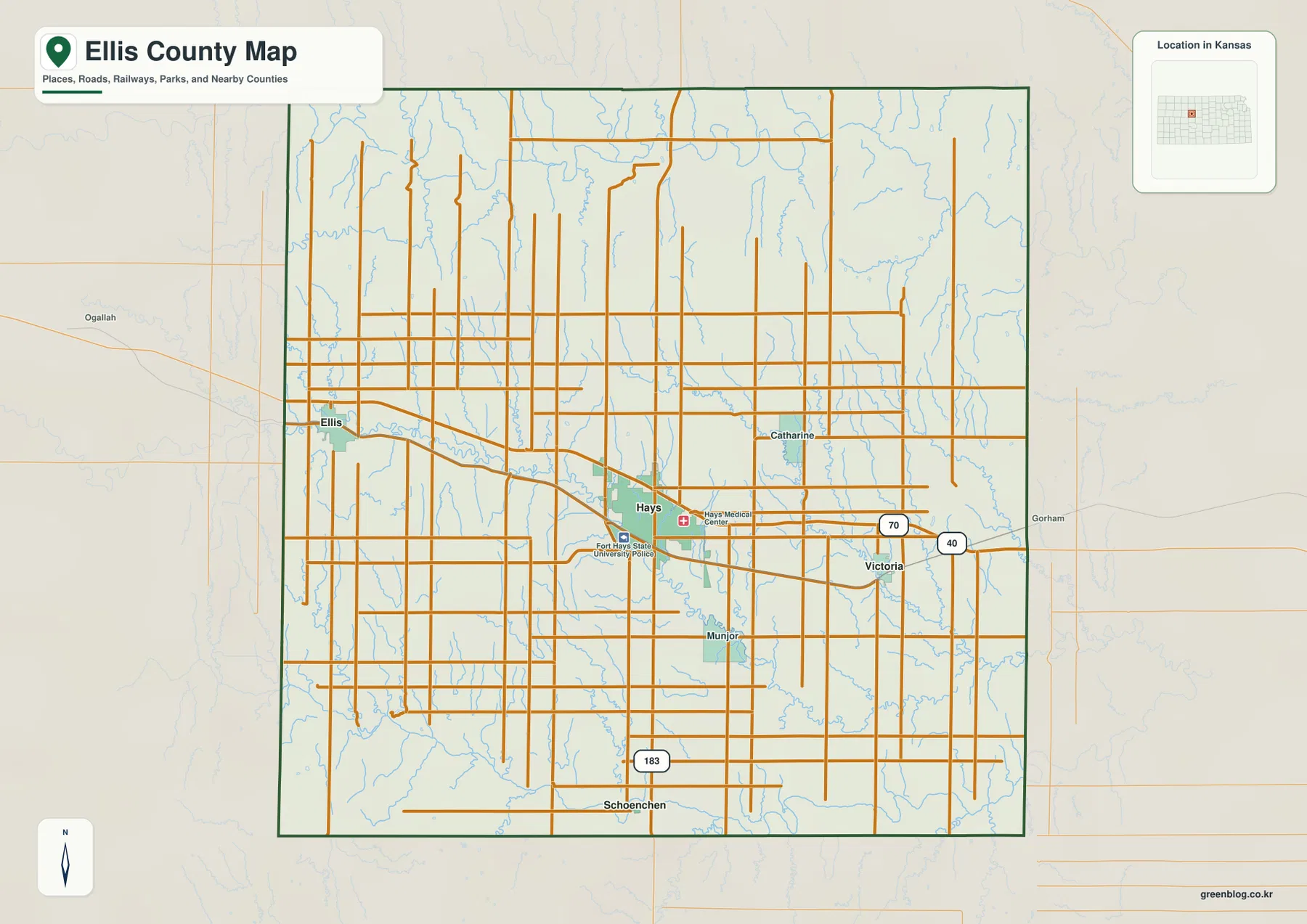
Outside the Hays urban area, settlement labels become sparse and the map is dominated by rural roads, creeks, and open land. The west around Ellis is more rugged at county scale, while the area east of Hays gradually drops in elevation. The map is designed for orientation rather than live navigation, so current road construction, closures, winter conditions, and other travel issues should be checked with an up-to-date transportation source.
Ellis and Victoria on either side of the Hays hub
The city connection map simplifies the county by placing Hays at the center of three useful comparisons. Ellis is shown about 13 miles west of Hays, Victoria about 10 miles east, and Schoenchen about 12 miles south. These are straight-line distances intended to communicate scale and direction. They are not road mileage and should not replace current driving directions.
The settlement positions also line up with changes in terrain. Ellis lies closer to the higher western uplands, while Victoria sits farther into the lower eastern side of the county. Schoenchen provides a southern reference toward the Smoky Hill River country. Hays therefore works as more than an administrative center: it is also a practical midpoint for comparing several different parts of Ellis County.
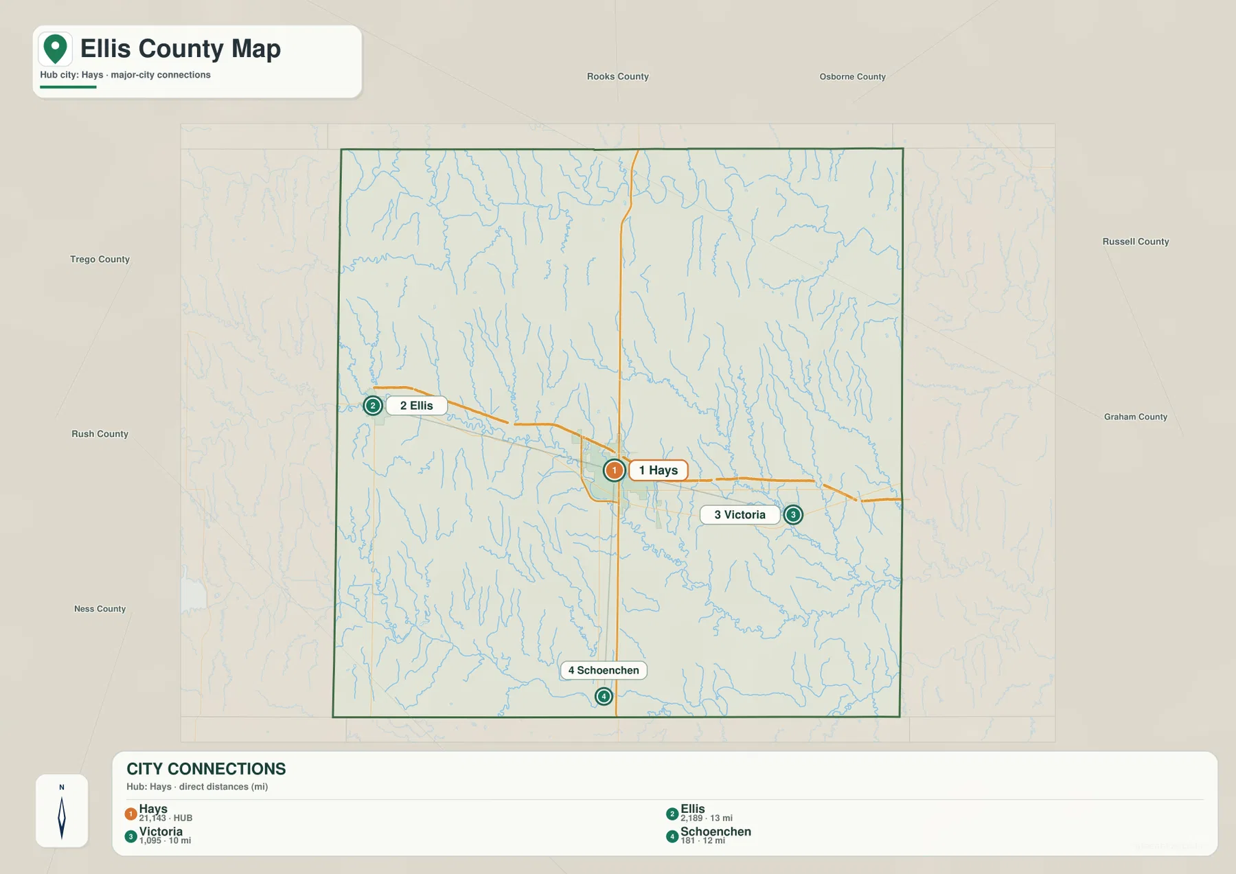
The official Ellis County website lists Hays, Ellis, Schoenchen, and Victoria among the county’s communities, and the Kansas Historical Society identifies Hays as the county seat. These sources match the pattern on the map. For a reader unfamiliar with the area, learning the Hays-centered relationship first makes the later water and elevation views much easier to follow.
Big Creek between the Saline and Smoky Hill rivers
The terrain and water map gives Ellis County a strong north-south frame. The Saline River crosses the northern part of the county, and the Smoky Hill River follows the southern side. Between them, Big Creek passes through the central area near Hays, while North Fork Big Creek extends across the east-central landscape. Numerous smaller tributaries connect the uplands to these larger drainage corridors.
Western and northwestern Ellis County contains Wild Horse Creek and Turkey Creek, which cut into the higher ground before joining larger systems. Sweetwater Creek is a useful northeastern reference, and Walker Creek runs through the eastern side. Rohr Jacobs Lake appears in the southwest. Together these features show that the space between the two major rivers is not an uninterrupted plain but a network of rolling divides and creek valleys.
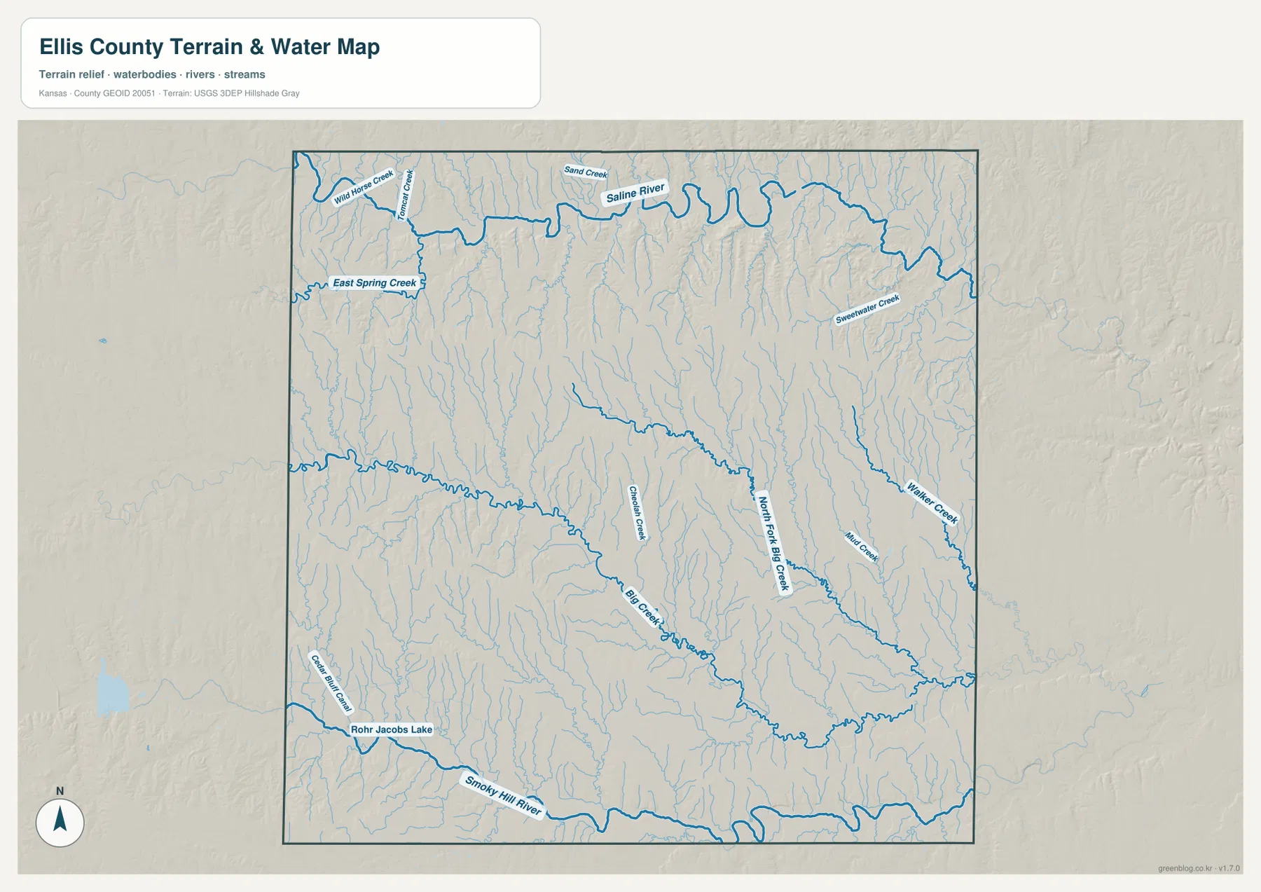
This map is a geographic reference rather than a live hydrology product. It is useful for seeing where valleys lie and how the Hays area relates to Big Creek, but it does not provide current streamflow, flood warnings, or water-quality conditions. Those questions require current observations from USGS or another responsible local or state agency.
From 717-meter western uplands to lower eastern terrain
The elevation map shows a county range of approximately 515 to 717 meters and a mean near 622 meters. The highest broad surfaces appear across much of the west and northwest, especially around the country west of Hays and toward Ellis. Hays occupies more moderate elevations, and the colors become progressively lower toward Victoria and the eastern part of the county.
The Saline River and Smoky Hill River occupy lower corridors along the northern and southern edges, while Big Creek creates a subtler low route through the center. The western terrain is not mountainous; it is a high rolling surface cut by many tributaries. East of Hays, the overall surface is lower, but the close spacing of creeks still creates local ridges and valleys.
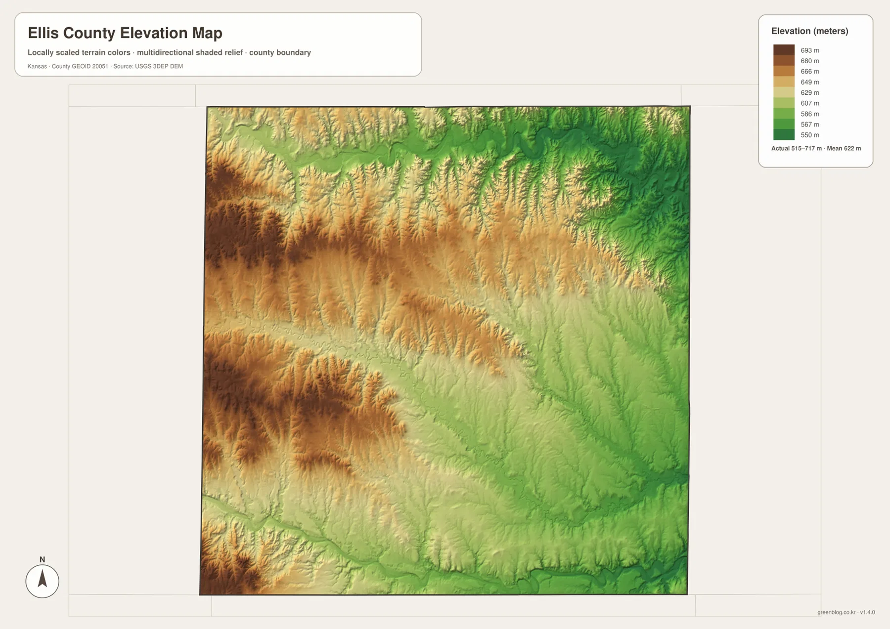
The elevation surface is intended for county-scale comparison rather than survey-grade measurement. It should not be used to establish an exact parcel elevation, design drainage, or replace engineering and legal survey data. Its value is context: readers can see how the Ellis–Hays–Victoria corridor crosses changing terrain and why many streams occupy the greener low bands on the map.
Smoky Hills terrain and the Fort Hays legacy
The Kansas Historical Society describes Ellis County as part of the Smoky Hills and notes the importance of local limestone in the region’s history. Stone fence posts became a familiar feature where timber was scarce, and the broader landscape reflects the rolling hills and exposed rock associated with western and central Kansas. The terrain map gives that historical description a geographic setting by showing repeated uplands and stream-cut valleys.
Hays also grew from a transportation and military history tied to Fort Hays and the westward railroad. The historic fort served travelers and railroad construction during the nineteenth century, while modern Hays became the county’s main service and education center. Fort Hays State University is marked on the map, linking a present-day institution with the same city that developed around earlier transportation routes.
This background explains why Hays stands out so strongly in the map set. The city sits on the main interstate corridor, occupies a central position between the two major rivers, and connects surrounding rural communities. Ellis and Victoria extend the corridor in opposite directions, while the creeks and rolling terrain shape the open country between the settlements.
Using the map files for study and printing
For general orientation, begin with the I-70 corridor and place Ellis, Hays, and Victoria in order. The city connection map is best when the goal is simply to compare settlement positions and straight-line distances. For physical geography, Big Creek provides a useful central reference before moving outward to the Saline River, Smoky Hill River, and the elevation surface.
The downloadable high-resolution JPG files are better suited than the reduced web previews for printing, classroom material, and close inspection of labels. They are useful for county overviews and regional comparisons, but current roads, live stream conditions, parcel boundaries, and exact elevations should always be checked against the latest authoritative sources when those details matter.
Frequently Asked Questions
Where is Hays on the Ellis County map?
Hays sits slightly east of the county center near I-70 and U.S. 40, with U.S. 183 extending south. Ellis is west of Hays and Victoria is east, making Hays the most useful first reference for locating the county’s principal communities.
How does Big Creek fit between the Saline and Smoky Hill rivers?
Big Creek crosses the central part of Ellis County near Hays, while the Saline River lies to the north and the Smoky Hill River to the south. North Fork Big Creek and other tributaries divide the uplands between those larger river corridors. The map shows their geographic relationship, not current flood or streamflow conditions.
Can the 515–717 meter elevation map be used for surveying?
No. The elevation map is a county-scale visual reference for comparing uplands, ridges, and valleys. Exact parcel elevations, construction design, drainage engineering, and legal surveys require purpose-built data and professional methods appropriate to those tasks.
Map File Information
Download the high-resolution JPG files corresponding to the Ellis County general, city connection, terrain-and-water, and elevation maps in one ZIP archive.
- Included Files: Use only the versions confirmed in the article and supplied images
- File Type: Use the confirmed download contents
- Intended Use: Printing, education, presentations, and map-based projects
Related Maps
Sources and references
- Ellis County, Kansas official website — county government and community information
- Kansas Historical Society — Ellis County, Kansas — Hays, Smoky Hills, Fort Hays, and regional history
- U.S. Census Bureau TIGER/Line — boundary and geographic data resources
- USGS National Hydrography — hydrography and stream-network data information
- USGS 3D Elevation Program — elevation data information
Green Map creates custom-edited map images using open geographic data sources such as geoBoundaries, Natural Earth, OpenStreetMap, and government open data.
These maps are edited visual materials, not raw data files, and are provided for education, documents, presentations, and graphic reference.