Cloud County sits in north-central Kansas, and its geography becomes much easier to follow once Concordia is used as the starting point. U.S. 81 runs north and south through the county, Concordia occupies the north-central area, Clyde lies toward the northeast, Jamestown is in the northwest, and Glasco and Miltonvale are separated across the southern half. The maps on this page connect those settlements with the Republican River, smaller creeks, and a county-wide elevation range of about 384 to 518 meters. High-resolution JPG copies of the maps shown here can be downloaded together from the ZIP box below. High-resolution map files are available for download in the section below.
The county has a strong north-to-south contrast. Across the north, the Republican River occupies a broad low corridor that is easy to trace on both the water and elevation maps. Farther south, the ground rises into rolling hills cut by many short tributary valleys. The contrast is especially useful because it gives the settlements a natural setting: Jamestown, Concordia, and Clyde are associated with the northern river belt, while Aurora, Glasco, and Miltonvale sit amid more dissected uplands and smaller streams.
These are reference maps rather than live navigation or engineering products. The general map is best for orientation, the city map reduces clutter so settlement spacing stands out, the water map names the main rivers and creeks, and the elevation map emphasizes the relief between valleys and higher ground. Instead of treating those as four separate subjects, the sections below follow the county from its towns and roads into the river valleys and hills that shape the landscape.
Table of Contents
Concordia as the road and location anchor
On the general county map, Concordia is the easiest place to establish direction. U.S. 81 crosses the county from north to south and passes through the city, giving the map a strong vertical reference. East-west roads connect Concordia with other parts of the county, while Clyde appears near the eastern edge and Jamestown occupies the opposite side in the northwest. Glasco is near the southwest, Miltonvale is in the southeast, and Aurora sits inland between the central and southeastern parts of the county.
The county boundary also helps place Cloud County within north-central Kansas. Republic County is to the north, Clay and Washington counties are shown to the east, and Mitchell and Ottawa counties appear to the west. Jewell County is labeled near the southwest side of the map. Those neighboring labels are useful for regional orientation, although the map is not intended to replace an official legal boundary survey.
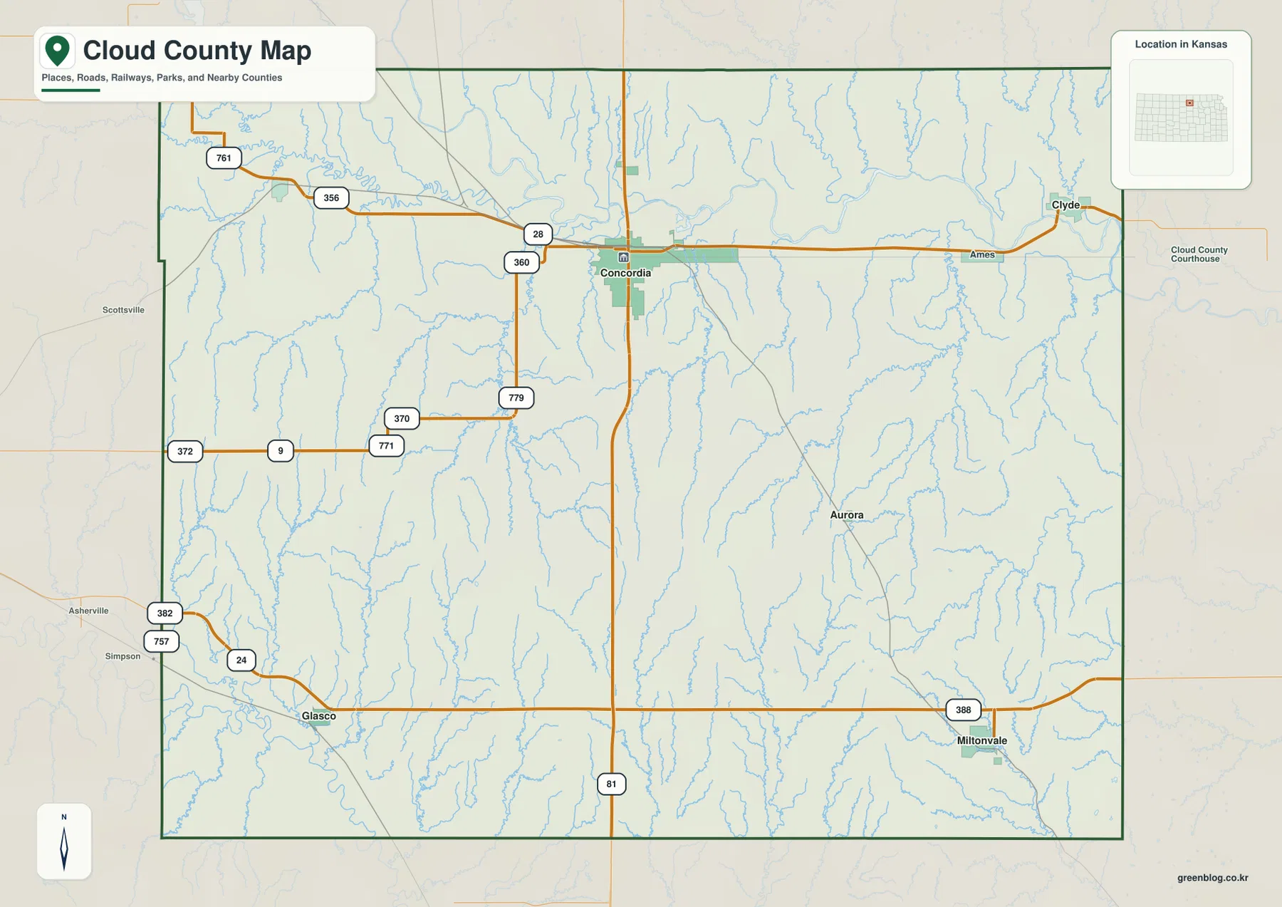
The stream network is already visible in pale blue beneath the road information. Near the north, the Republican River provides a natural east-west counterpart to the north-south highway. South of the river, smaller creeks cut across the hills rather than forming one continuous broad valley. That relationship between transportation and terrain is one reason the general map works well as the first reference before moving to the more specialized water and elevation views.
Six principal communities spread across a rural county
The city map ranks six communities and makes their spacing much clearer than the general map. Its production-period values list Concordia at 5,015, Clyde at 792, Miltonvale at 474, Glasco at 368, Jamestown at 174, and Aurora at 25. These should not be treated as a substitute for the latest Census estimates. Their main value here is to show the hierarchy and placement of the settlements at the time the map was prepared.
Concordia is clearly the dominant center, but the smaller towns are not arranged in a single corridor. Clyde is well to the northeast, Jamestown is well to the northwest, and Miltonvale and Glasco occupy opposite sides of the southern half. Aurora is a small inland point southeast of Concordia. The result is a dispersed settlement pattern in which the county seat provides a useful anchor but does not visually absorb the rest of the county.
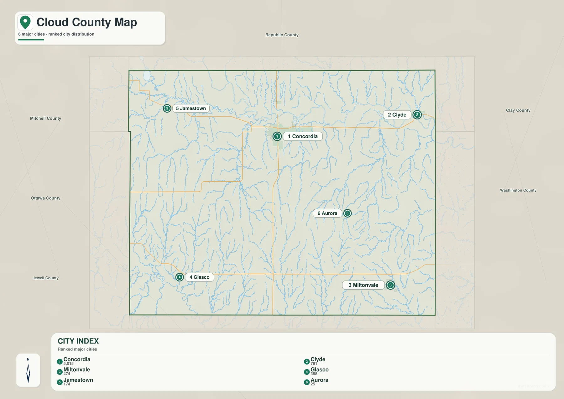
The straight connector lines on the city map are visual comparisons, not road routes or driving distances. That distinction matters in a county with numerous creeks and rolling ground, because an actual trip may follow a very different path from a direct line. For location study, however, the simplified layout makes it easy to remember that Concordia is north-central, Clyde and Jamestown occupy opposite ends of the northern belt, and the two larger southern communities are separated by a broad interior.
The Republican River corridor across the north
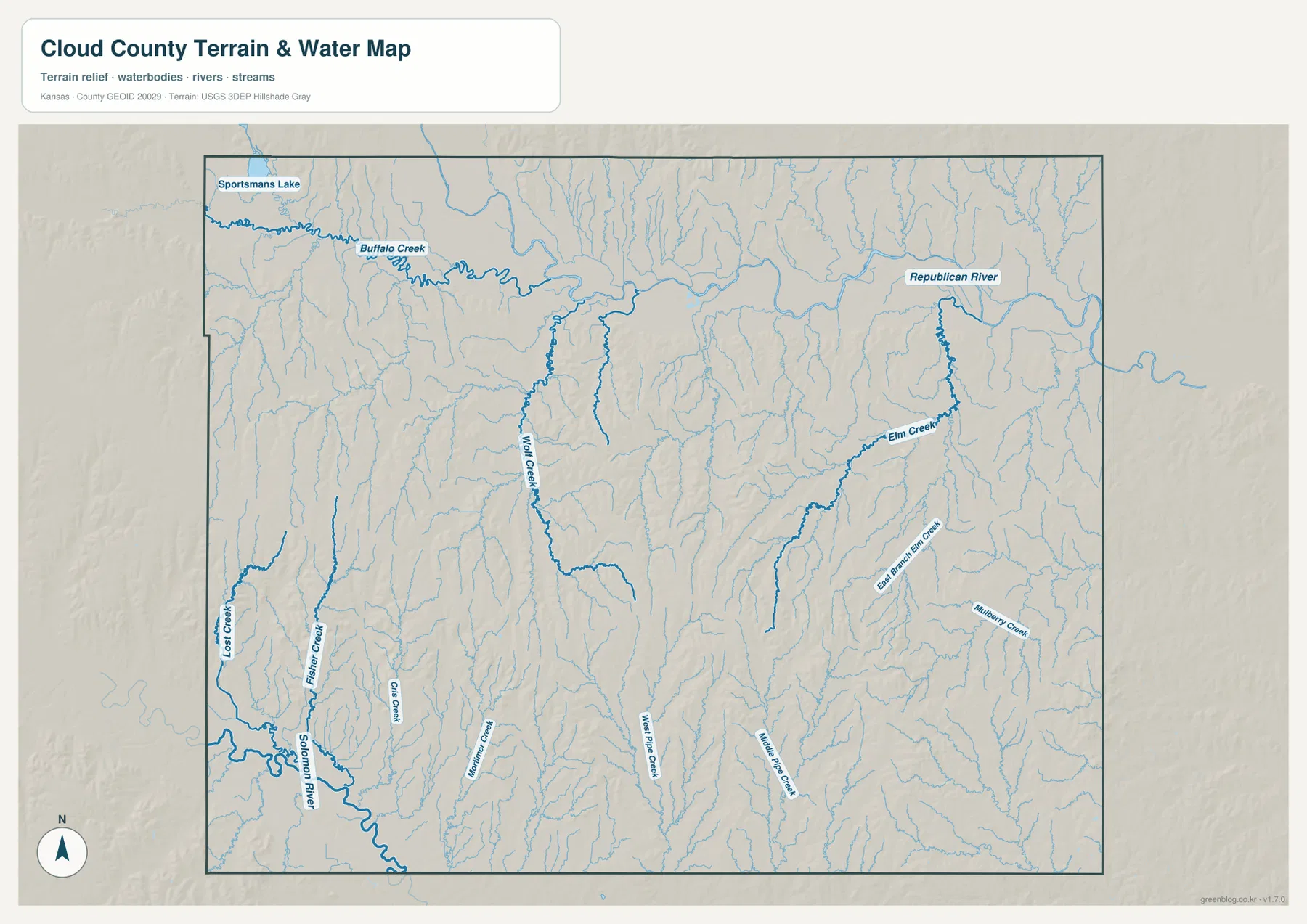
The water and terrain map makes the Republican River the defining feature of northern Cloud County. It enters from the northwest and travels generally eastward across the upper part of the county before leaving near the eastern side. Its broad course is joined by several smaller channels, and the surrounding terrain is visibly smoother and lower than many of the hills farther south. Concordia lies close enough to this corridor that the river remains a useful natural reference when locating the county seat.
Buffalo Creek is prominent in the northwest, where it approaches the Republican River near the Jamestown area. Wolf Creek extends northward through the central part of the county. Farther east, Elm Creek and East Branch Elm Creek form long tributary lines, while Mulberry Creek appears in the southeast. The southern interior contains smaller named streams including Holliman Creek, West Pipe Creek, and East Pipe Creek, each occupying a narrow valley between higher ridges.
The southwest has a different drainage reference. The Solomon River appears near the corner of the county, with Fisher Creek and Lost Creek nearby. Sportsmans Lake is labeled near the northwest edge. Taken together, these features show that the county is divided between two larger river settings and many smaller tributary valleys. The map is suitable for geographic reference, not for current streamflow, flood-warning, wetland-jurisdiction, or navigation decisions.
A 384–518 meter landscape of river bottoms and rolling uplands
The elevation map gives Cloud County an indicated range of roughly 384 to 518 meters, with a mean near 440 meters. The lowest broad feature is the Republican River corridor across the north, rendered in dark green. A second low area follows the Solomon River near the southwest corner. Between those valleys, the county rises into extensive rolling uplands shown in lighter greens, yellows, oranges, and browns.
The central and southern parts are especially textured. Short tributaries have cut many narrow valleys into the higher ground, so the shaded relief shows repeated ridges rather than one simple slope. The warmest colors are concentrated across parts of the west-central and south-central uplands, while lower green fingers extend into them along stream valleys. This makes the water map and elevation map particularly useful as a pair: named creeks on one often correspond to narrow lower channels on the other.
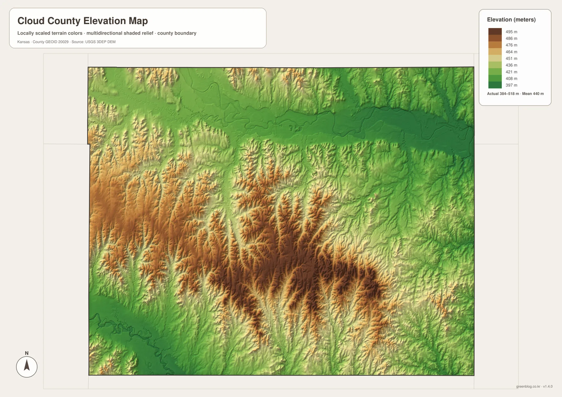
The elevation surface is designed for broad comparison rather than site-specific measurement. A color boundary does not represent a surveyed contour for an individual property, and the map should not be used for engineering grades, drainage design, or construction staking. For regional explanation, though, the contrast is clear: river bottoms occupy the lowest bands, while most of the county between the major rivers stands higher and is broken by many tributary valleys.
From Jamestown and Clyde to the southern hill country
The northern communities can be understood as a loose sequence along the broad river region. Jamestown lies toward the northwest near Buffalo Creek and the Sportsmans Lake area. Concordia is farther east and closer to U.S. 81, while Clyde is near the northeastern edge. They are not continuous urban development, but the Republican River provides a shared geographic backdrop that makes their positions easier to remember.
South of Concordia, the character of the map changes. Glasco lies in the southwest and Miltonvale in the southeast, with Aurora farther north and inland. The terrain between them is crossed by many smaller streams rather than one dominant river. On the elevation map, that interior is also more rugged, with alternating ridges and narrow green valleys. The contrast explains why the county can appear relatively simple on a road map but much more varied once terrain is added.
For a quick mental map, the north can be remembered by the Republican River and the Jamestown–Concordia–Clyde spread, while the south can be remembered by Glasco, Miltonvale, and the rolling tributary country between them. This is more useful than memorizing every road number because it ties settlement locations to large, persistent geographic features.
Local context beyond the map symbols
Cloud County Tourism identifies Concordia, Jamestown, Clyde, Aurora, Glasco, and Miltonvale as the county’s communities and describes the county as part of north-central Kansas. Its visitor information also notes both the Republican and Solomon rivers and highlights the Jamestown Wildlife Area in the northwest. Those local references fit the physical features visible in the supplied maps and give the labeled places a useful real-world context.
Concordia remains the most practical starting point for combining that local context with the maps. The city is the county seat and the largest settlement shown in the city index. U.S. 81 passes through it, and the Republican River lowland is close by. From Concordia, a reader can move outward to Clyde and Jamestown in the north, then shift south toward Glasco, Aurora, and Miltonvale to compare how settlement changes as the terrain becomes more rolling.
Local tourism resources and map resources answer different questions. Visitor pages are useful for attractions, community history, and trip ideas. The maps here are better for seeing the county’s shape, town spacing, drainage, and relief. Used together, they provide a fuller picture without asking either source to do a job it was not designed to perform.
Choosing the right map for a specific task
Choose the general county map when you need boundaries, roads, communities, and streams on one page. It is the clearest choice for locating Concordia on U.S. 81, seeing where Clyde and Jamestown sit relative to it, or comparing the southern positions of Glasco and Miltonvale. The city map is better when the objective is simply to compare the principal settlements without the visual weight of the full road network.
Use the water and terrain map when river and creek names matter. It provides the clearest view of the Republican River, Buffalo Creek, Wolf Creek, Elm Creek, the Solomon River, and the smaller tributaries that cut the uplands. The elevation map is the strongest choice for explaining why the north looks different from much of the interior: the Republican River corridor is lower, while the central and southern parts contain extensive higher ground broken by narrow valleys.
The web versions are convenient for quick viewing, while the downloadable high-resolution JPG files are better suited to larger displays, classroom materials, reports, or print layouts. They remain static reference maps. Current road closures, stream conditions, parcel boundaries, legal surveys, and precise elevations should always be checked against the latest authoritative source for the specific task.
Frequently Asked Questions
Why is Concordia the best starting point on the Cloud County maps?
Concordia is the largest settlement shown, lies near the north-central part of the county, and sits on U.S. 81 close to the Republican River lowland. That combination makes it a convenient anchor for locating Clyde and Jamestown to either side of the northern belt and for moving south toward Glasco, Aurora, and Miltonvale.
What causes the strong low band across northern Cloud County?
The dark green band on the elevation map follows the broad Republican River valley. The river and its floodplain occupy lower ground than the surrounding rolling uplands, so the corridor stands out clearly against the warmer colors of the interior hills. The map shows regional relief rather than survey-grade elevation for individual sites.
Are the population values on the city map current?
They should be treated as production-period reference values, not as a guarantee of the latest population counts. For current statistics, consult the latest U.S. Census Bureau data. On this page, the city map is most useful for comparing the relative locations and size hierarchy of Concordia, Clyde, Miltonvale, Glasco, Jamestown, and Aurora.
Map File Information
Download the high-resolution source maps corresponding to the Cloud County maps shown on this page.
- File Type: High-resolution JPG
Related Maps
Sources and References
- U.S. Census Bureau TIGER/Line Shapefiles – county boundary, road, and geographic reference data
- USGS National Hydrography – river and stream reference data
- USGS 3D Elevation Program – elevation and terrain reference data
- Cloud County Tourism – local community, river, wildlife-area, and visitor context
Green Map creates custom-edited map images using open geographic data sources such as geoBoundaries, Natural Earth, OpenStreetMap, and government open data.
These maps are edited visual materials, not raw data files, and are provided for education, documents, presentations, and graphic reference.