Davis County sits in southeastern Iowa, with Bloomfield serving as the clearest reference point for understanding the county on these maps. U.S. 63 runs north–south through the central part of the county, while Iowa 2 passes through the Bloomfield area and continues toward Pulaski in the southeast. Drakesville lies northwest of Bloomfield, Floris is to the northeast, and Pulaski is to the southeast. Beyond those settlement and road patterns, the supplied maps show a dense network of creeks, the South and North Wyaconda rivers, the Fox River system, Lake Wapello and Lake Fisher, and a pronounced change in elevation from higher western hills to lower eastern valleys. The images on this page are web-sized previews, and the download section provides the same map subjects as high-resolution JPG files in a ZIP archive.
A useful way to read Davis County is to start with Bloomfield and then add one layer of information at a time. The city-connections map makes the small network of nearby communities easy to grasp, but the terrain and water map shows that the countryside between those places is cut by many narrow valleys. The elevation map reinforces that relationship: stream corridors appear as lower green bands while higher ridges are especially prominent in the west and southwest. Looking at the maps together explains why a simple road network can cross a landscape that is much more varied than it first appears.
Table of Contents
Using Bloomfield, U.S. 63, and Iowa 2 to orient the county
Bloomfield is the easiest place to begin on the county map because it sits near the middle of the road network and close to the intersection of the county’s main north–south and east–west routes. U.S. 63 passes through the Bloomfield area and continues north toward the upper county line, giving the map a strong vertical reference. Iowa 2 extends through the southern half of the county and toward Pulaski. Once those two routes are located, the positions of Drakesville, Floris, and the smaller local roads become much easier to place.
Drakesville appears northwest of Bloomfield inside a network of local roads, while Floris sits to the northeast and east of U.S. 63. Pulaski is southeast of Bloomfield and close to Iowa 2. An Iowa 16 shield also appears near the northeastern edge of the map, helping mark that corner of the county. These route lines are useful for geographic orientation, but the map is not a live navigation product. Current closures, construction, travel times, and driveway-level directions should be checked with an up-to-date routing service before a trip.
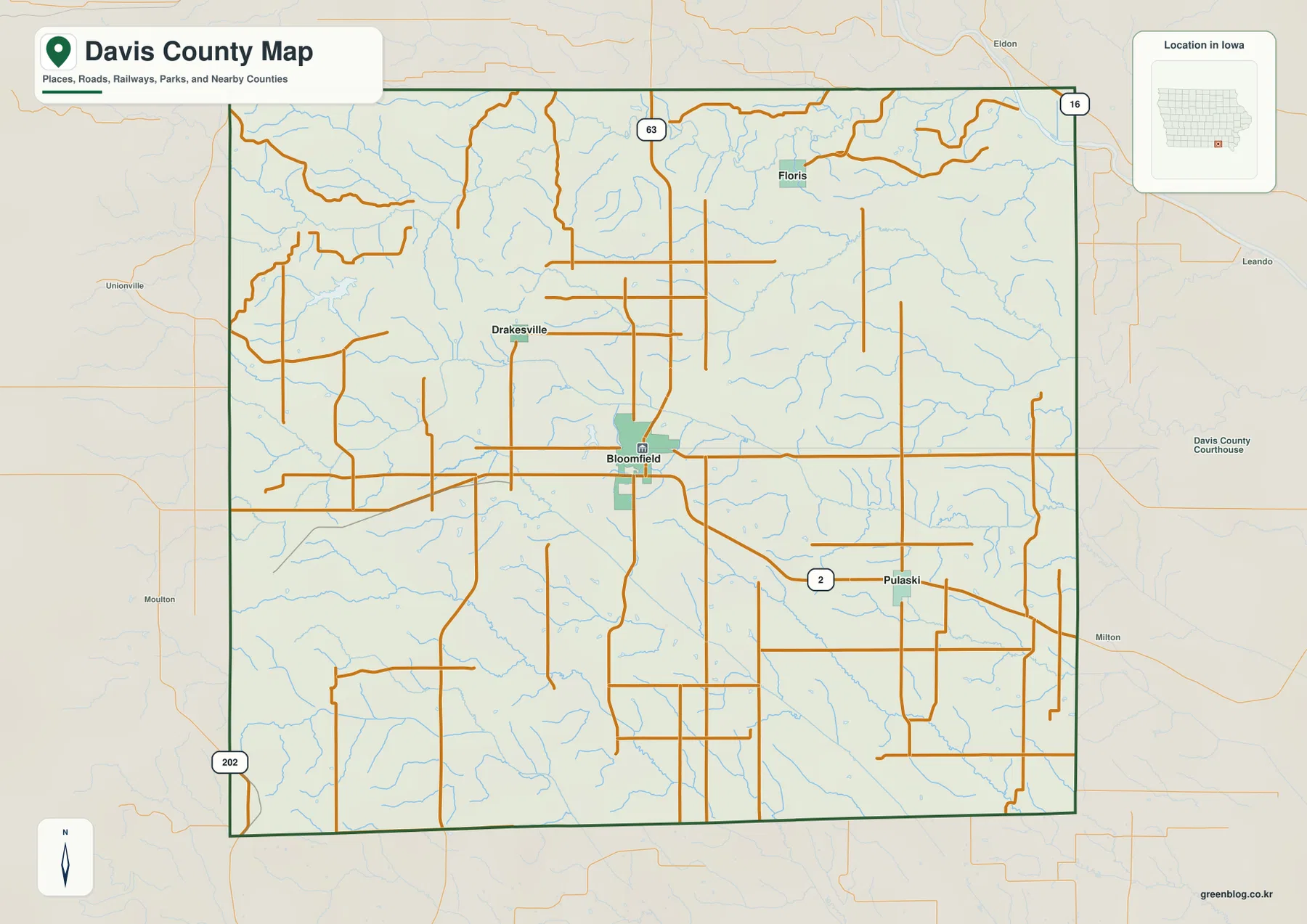
The names outside the county boundary provide additional context without changing the focus of the page. Eldon is shown beyond the northern edge, Milton and Leando appear to the east, and Moulton and Unionville are visible to the west. Those labels help place Davis County within southeastern Iowa and make the county boundary easier to recognize. They should not be read as a complete list of neighboring communities or as a substitute for a regional road map; the purpose here is to explain the internal arrangement of Davis County and the features shown on the supplied maps.
Bloomfield as the hub for Pulaski, Drakesville, and Floris
The city-connections map strips away much of the road detail and emphasizes four settlements: Bloomfield, Pulaski, Drakesville, and Floris. Bloomfield is the hub. The legend shows direct, straight-line distances of about 5 miles to Drakesville, 8 miles to Pulaski, and 9 miles to Floris. Those are not driving distances, but they are useful for understanding the scale of the county and the relative spacing of the communities. Drakesville is the closest of the three to Bloomfield on this map, while Pulaski and Floris sit farther away in different directions.
The arrangement is easy to remember once the directions are tied to Bloomfield. Drakesville is northwest, Pulaski is southeast, and Floris is northeast. Returning to the county map after learning those positions makes the road system more intuitive: Iowa 2 helps anchor the route toward Pulaski, while U.S. 63 forms the major north–south reference through Bloomfield. Floris lies farther east of that north–south line, and Drakesville occupies the road network to the northwest. This approach is more useful than memorizing a long list of road names because each place is attached to a clear geographic relationship.
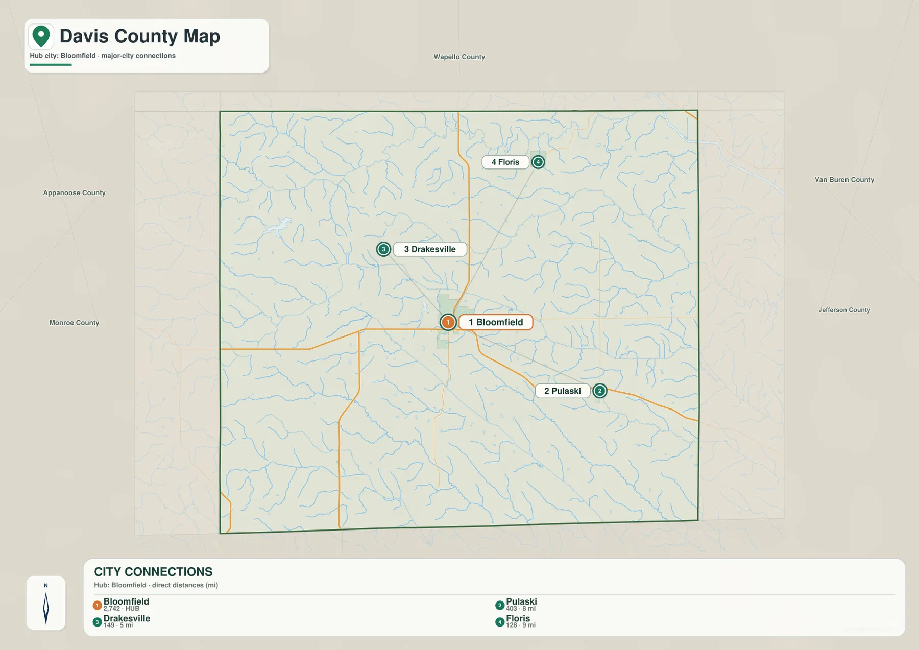
This simplified city view is especially helpful when the full county map feels busy. It gives a clear sense of where the named communities sit before the reader adds roads, streams, and relief. Pulaski and Floris can sound like nearby eastern points when read in a list, yet the map shows that one is southeast and the other northeast, with considerable space between them. Drakesville occupies a different part of the county to the northwest. That separation becomes important when comparing each town with the different river valleys shown on the water map.
Wyaconda, Fox, and Fabius waterways divide the southern landscape
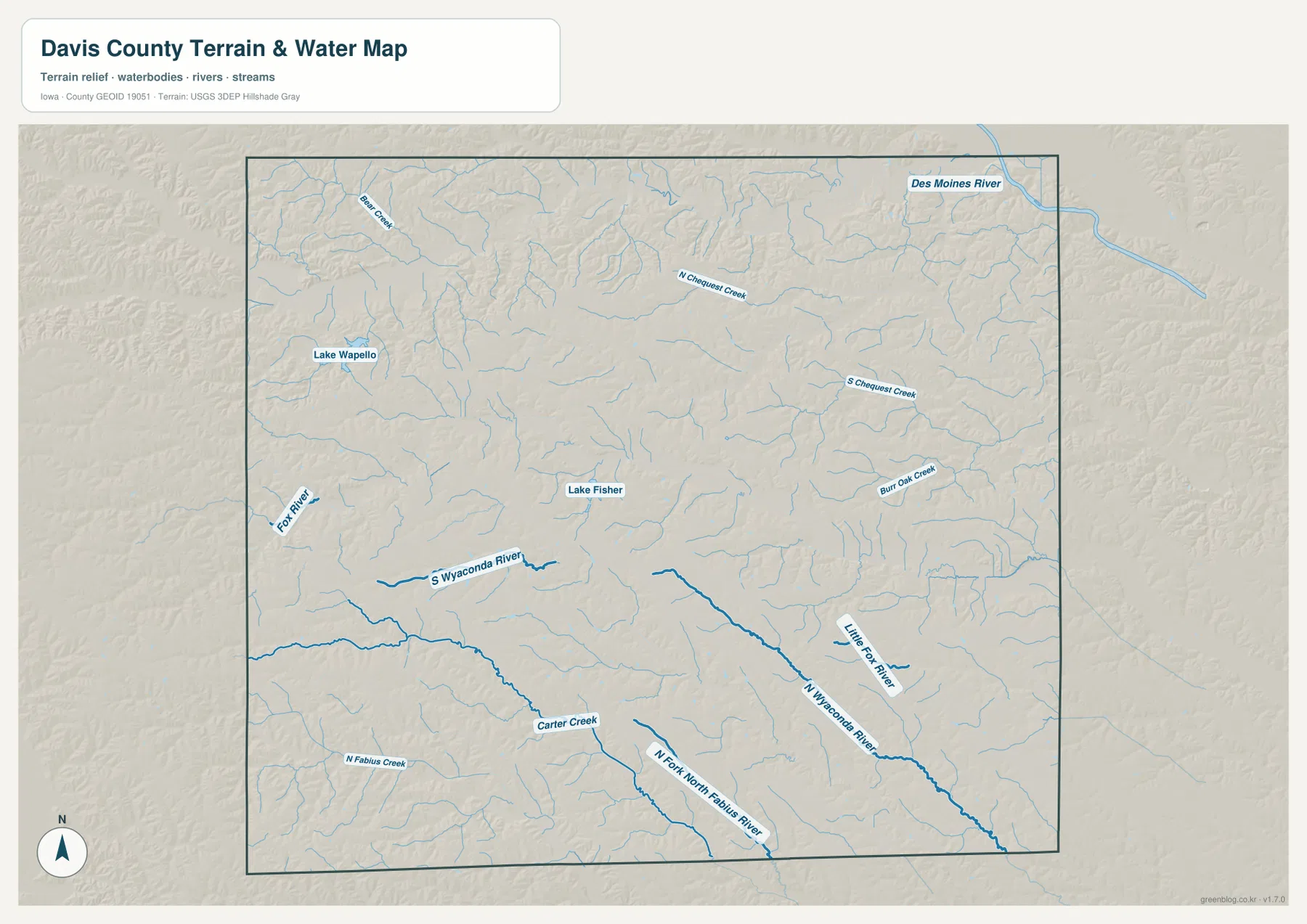
The terrain and water map shows a much more intricate landscape than the road map alone suggests. The Fox River is labeled along the western side, and the South Wyaconda River runs across the west-central part of the county. Farther southeast, the North Wyaconda River becomes one of the strongest blue lines on the map, with the Little Fox River joining the same general southeastern landscape. Near the southern county line, the North Fork North Fabius River and North Fabius Creek form another separate drainage system. These large streams are divided by ridges that are in turn cut by many smaller tributaries.
Several named creeks make those smaller divisions visible. Bear Creek appears in the northwest, North Chequest Creek and South Chequest Creek cross the northern and eastern interior, Burr Oak Creek is labeled farther east, and Carter Creek is shown in the south. The pattern is not a single broad valley with flat ground on either side. Instead, stream after stream branches into the uplands, producing many short ridges and narrow valleys. That is one reason the elevation map looks so textured, especially in the west and southwest where higher ground is dissected by tributaries.
Lake Wapello and Lake Fisher provide two easy landmarks within this complicated water network. Lake Wapello is shown in the west-central part of the county, while Lake Fisher lies closer to the middle. The Des Moines River is also labeled just beyond the northeastern edge of the county map, providing broader regional context rather than serving as an interior Davis County waterway. The water map should be used for relative location and terrain understanding. It is not a flood map, parcel map, depth chart, or navigation chart, and it should not be used to make decisions about current water conditions.
Elevation from 183 to 304 meters reveals western ridges and eastern valleys
The elevation map gives Davis County an actual mapped range of about 183 to 304 meters, with a mean of 252 meters. The strongest contrast is between the higher brown and orange terrain in the west and southwest and the greener, lower areas toward the east and northeast. The transition is not smooth. Narrow green valleys push into the higher ground along stream corridors, so the map looks like a branching network of lower channels separated by rolling ridges. This shape matches the dense creek system visible on the terrain and water map.
The southwestern part of the county contains some of the darkest higher-elevation colors and a particularly rugged pattern of short ridges. Moving through the central area, broader lower corridors begin to cut across the landscape, while the eastern side contains more extensive green terrain. Even there, smaller ridges remain between tributaries, so “lower” does not mean perfectly flat. The northern part of the county is similarly broken by small stream valleys. Readers who want to understand the topography should therefore compare the elevation map with the named waterways rather than relying only on the maximum and minimum numbers.

This elevation surface is designed for county-scale comparison, not survey-grade measurement. A single color band can contain many different elevations, and short slopes near creeks may change quickly over a small distance. Construction, drainage design, property work, or any task that depends on precise elevation requires the original elevation data or professional surveying. For this page, the value of the map is that it makes the relationship between streams, valleys, and uplands easy to see at a glance.
Connecting the town pattern to the river valleys
Reading the four maps together gives a more complete picture of Davis County than any one map provides on its own. Bloomfield is the road and settlement reference point, with U.S. 63 and Iowa 2 establishing the main directions. The city map then shows how Drakesville, Pulaski, and Floris are distributed around that hub. The water map adds a second layer of structure: different sections of the county are cut by the Wyaconda, Fox, and Fabius systems, with numerous creeks in between. Finally, the elevation map shows those same corridors as lower valleys between higher ridges.
Pulaski is a good example of how those layers work together. It sits southeast of Bloomfield and near Iowa 2 on the road map, while the larger North Wyaconda and Little Fox river valleys are farther south and southeast. Drakesville is northwest of Bloomfield, closer to the western portion of the drainage network and higher rolling terrain. Floris occupies the northeastern side of the settlement pattern, where the Chequest creeks and lower eastern relief become more relevant. Linking each town to a road and nearby terrain feature makes the geography easier to remember than treating town names as isolated points.
Lake Wapello and Lake Fisher as landmarks in a dense stream network
When a county contains many small creeks, lakes can serve as useful fixed landmarks. Lake Wapello is easy to locate in the west-central area, and Lake Fisher provides another reference closer to the county’s middle. Once those two water bodies are found, the reader can trace the South Wyaconda River and Fox River system to the west and then shift toward the North Wyaconda and Little Fox River corridors in the southeast. That method turns a crowded stream map into a sequence of recognizable zones rather than a collection of disconnected blue lines.
The elevation map adds another reason to use the lakes as reference points. Lower terrain extends along many watercourses, while the ridges between them rise into yellow, orange, and brown bands. Comparing the same location on both maps shows how water and relief fit together. The maps do not attempt to show shoreline access, recreation rules, water levels, or facility status, so anyone planning an actual visit should check the appropriate current management information. Here, the lakes are geographic landmarks used to make the broader county terrain easier to understand.
Choosing the Davis County map that fits the task
For basic orientation, start with the county map and find Bloomfield, U.S. 63, and Iowa 2. Those three features provide enough structure to locate Drakesville, Floris, Pulaski, and the county boundary without studying every local road. If the goal is simply to compare the named communities, the city-connections map is cleaner. Its straight-line distance labels are useful for understanding relative spacing, especially when explaining the county to someone who has not seen the area before.
For rivers and terrain, begin with the South and North Wyaconda rivers and the Fox River, then use Lake Wapello and Lake Fisher as fixed landmarks. After that, switch to the elevation map and look for the lower green corridors in the same areas. If elevation is the main interest, reverse the process: compare the higher western and southwestern ridges with the lower east and northeast, then return to the water map to identify which streams occupy the major valleys. This back-and-forth comparison is especially useful because the county’s relief is shaped by many tributaries rather than one dominant valley.
The WebP images in the article are sized for quick viewing on a web page. For printing, classroom material, presentations, or closer visual inspection, the ZIP below contains high-resolution JPG versions of the county overview, city-connections, terrain-and-water, and elevation maps. They are suitable for general geographic reference, but they do not replace legal boundary records, parcel information, live road conditions, flood information, or precise survey data.
Frequently Asked Questions
Which map is best for comparing Bloomfield, Pulaski, Drakesville, and Floris?
The city-connections map is the clearest choice when the main goal is to compare settlement positions. It places Bloomfield at the hub and shows Drakesville about 5 miles away, Pulaski about 8 miles away, and Floris about 9 miles away by straight-line distance. To add road context, use the county map next and connect those locations to U.S. 63 and Iowa 2.
What are the most visible rivers and lakes on the Davis County water map?
The supplied water map labels the South and North Wyaconda rivers, Fox River, Little Fox River, North Fork North Fabius River, and several named creeks. Lake Wapello and Lake Fisher are also shown and work well as fixed landmarks when tracing the surrounding drainage network. The Des Moines River appears beyond the northeastern edge as regional context rather than as a major interior county waterway.
How should the 183–304 meter elevation range be interpreted?
The map shows higher ground concentrated mainly in the west and southwest, with lower green terrain becoming more common toward the east and northeast. The mean elevation is 252 meters, and stream valleys form narrow low corridors between the ridges. These values are intended for county-scale comparison; exact elevations for a property, structure, or engineering task require original elevation data or professional surveying.
Map File Information
The ZIP contains high-resolution JPG versions of the Davis County overview, city-connections, terrain-and-water, and elevation maps.
- Included Files: Use only the versions confirmed in the article and supplied images
- File Type: Use the confirmed download contents
- Intended Use: Printing, education, presentations, and map-based projects
Related Maps
Sources and reference data
The official links below are useful for checking the boundary, hydrography, and elevation datasets that support county-scale map work. The maps on this page are simplified for regional understanding, so use the original datasets when a task requires exact geometry or elevation values.
These maps are general-reference resources for orientation, learning, printing, and presentation use. Legal boundaries, property ownership, current road conditions, flood hazards, and precise elevations should always be checked against the responsible agency’s current records and appropriate professional data.
Green Map creates custom-edited map images using open geographic data sources such as geoBoundaries, Natural Earth, OpenStreetMap, and government open data.
These maps are edited visual materials, not raw data files, and are provided for education, documents, presentations, and graphic reference.