Appanoose County sits along Iowa’s southern tier, with Centerville near the middle of the county, Rathbun Lake dominating the northwestern water landscape, and the Chariton River system cutting through a broad area of rolling ground. The maps on this page separate those pieces so they are easier to understand. The general county map shows roads, communities, boundaries, and smaller streams; the city map highlights six major places; the terrain-and-water map names the lake, reservoirs, river, and creeks; and the elevation map shows how the county’s valleys sit below the surrounding uplands. High-resolution JPG versions of the same maps are available together in the download box farther down the page.
Centerville is the clearest orientation point on the maps. Roads approach it from several directions, and the surrounding labels are denser than around any other community. Moravia lies to the north near the Rathbun Lake area, Mystic is northwest of Centerville, Moulton is to the east-southeast, Cincinnati is southwest, and Unionville is northeast. Smaller places such as Plano, Numa, Exline, Rathbun, and Udell fill in the spaces between them. That distribution makes the county more useful to read as several connected local areas rather than as one town surrounded by an empty rural grid.
Official local and federal sources help explain why the water and terrain maps are so important here. The U.S. Army Corps of Engineers states that Rathbun Dam is in Appanoose County and that the reservoir extends westward into neighboring Lucas, Wayne, and Monroe counties, with the Chariton River and its South Fork serving as major water sources. Appanoose County Conservation describes Sharon Bluffs east of Centerville on the bluffs above the Chariton River and Lelah Bradley on the southwest side of Centerville with upper and lower reservoirs. Those features match the strong lake-and-valley pattern visible in the supplied maps, so the discussion below follows the county from Centerville toward Rathbun Lake and then through the Chariton drainage.
Table of Contents
Centerville anchors a road network spread across the county
The general county map places Centerville close to the center, where several major roads and local routes converge. Route shields for 2, 5, 129, and 202 are visible in different parts of the county, providing useful landmarks for following the wider road pattern. Many rural road segments are fairly straight, but the network changes direction around larger valleys, reservoirs, and the more irregular northern lake country. The result is a map that combines a familiar agricultural road grid with a landscape that is more dissected than the straight lines initially suggest.
North of Centerville, Rathbun and Moravia occupy the approach to the Rathbun Lake area. Rathbun is a small settlement close to the reservoir’s southern side, while Moravia lies farther north where several roads meet. Mystic appears northwest of Centerville near a concentration of water and green-space symbols. To the west, Plano marks another rural community, while Numa and Exline help identify the southern half of the county. These smaller places are useful reference points because they make it easier to match roads on the general map with valleys and streams on the other layers.
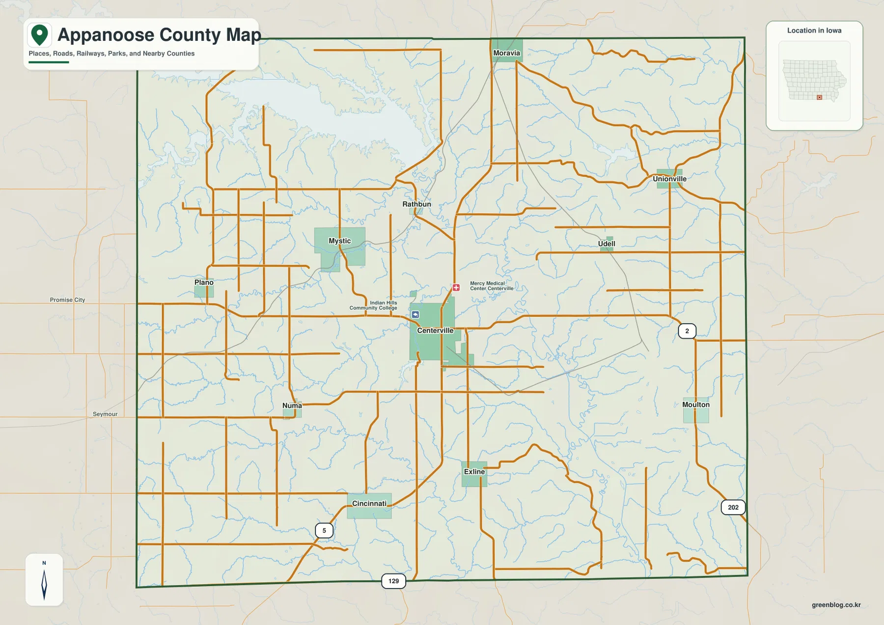
Moulton stands out in the eastern part of the county, while Unionville is farther north and Udell appears between the larger eastern communities. The surrounding county labels also help place Appanoose within southern Iowa: Monroe County is shown to the north, Wayne and Lucas to the west, and Davis and Wapello to the east. The Missouri state line forms the broader southern context even though the preview is focused tightly on the Iowa county itself.
One of the most useful details on the general map is the dense network of pale-blue streams. They cross areas that otherwise look like simple blocks of rural roads, especially north and east of Centerville, around Mystic, and through the southern countryside near Exline and Cincinnati. Those lines are the first clue that Appanoose County is made of many small ridges and valleys rather than one flat surface. The terrain-and-water map gives those drainage features names, while the elevation map turns many of the same routes into green lowlands.
Six mapped cities show how settlement spreads beyond Centerville
The city distribution map strips away much of the road detail and emphasizes six places: Centerville, Moravia, Moulton, Cincinnati, Mystic, and Unionville. Centerville is ranked first and sits near the middle of the county. Moravia is north of it, Moulton is to the east-southeast, Cincinnati is southwest, Mystic is northwest, and Unionville is northeast. That arrangement gives a quick picture of how the county’s main named communities are spread in several directions instead of forming a single north-south or east-west chain.
The CITY INDEX printed below the map lists reference values of 5,372 for Centerville, 624 for Moravia, 498 for Moulton, 229 for Cincinnati, 216 for Mystic, and 78 for Unionville. These figures are best treated as the ranking values used to build this map, not as a substitute for the latest Census estimates. Their main value here is comparative: Centerville is much larger than the other mapped communities, while the remaining five provide orientation points around the county.
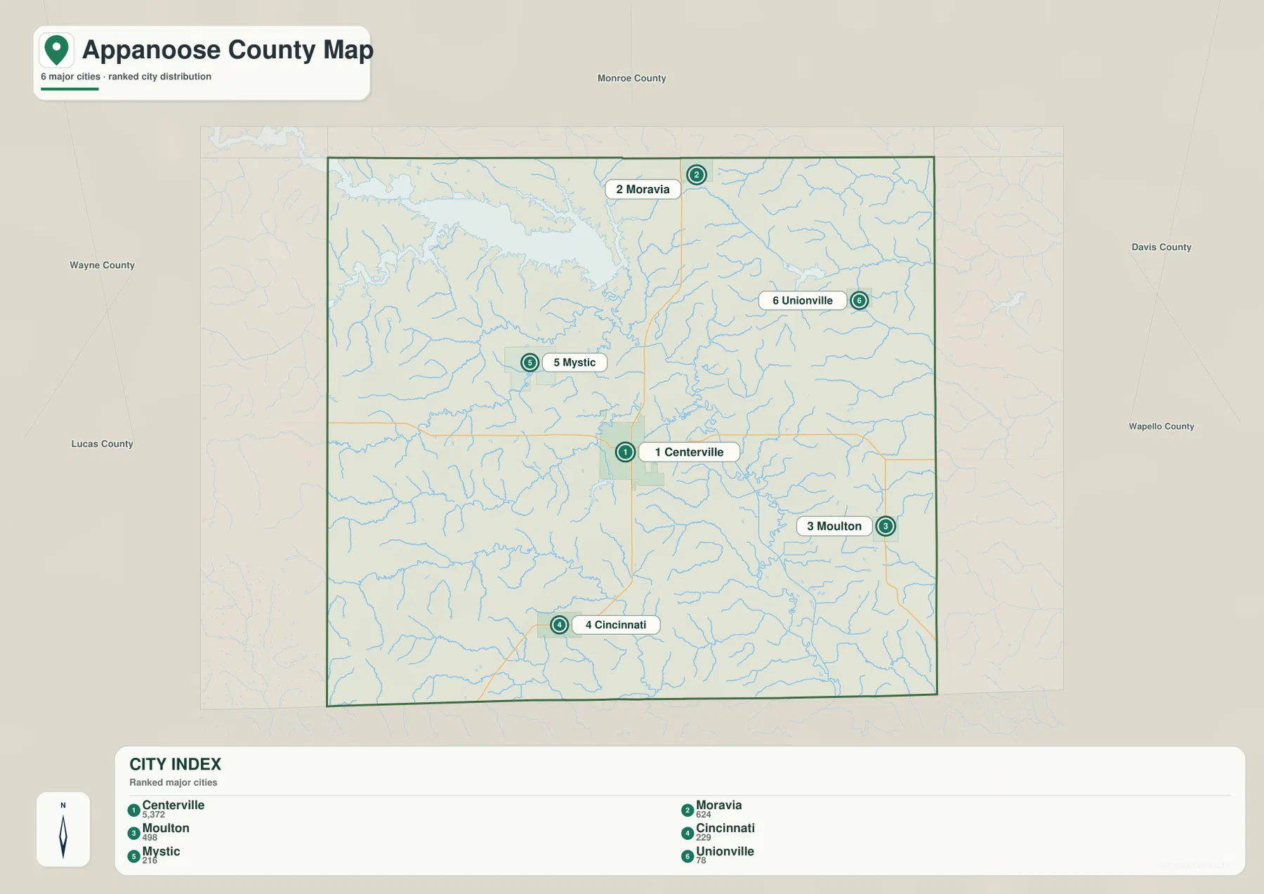
Centerville’s central position explains why it works so well as a reference point. Moravia leads toward the northern lake district, Mystic sits closer to the reservoir-and-creek country northwest of town, Moulton identifies the eastern side, and Cincinnati helps define the southwest. Unionville is near the northeastern part of the county, away from Centerville’s denser cluster of roads and services. Switching back to the general map after locating these six cities makes it much easier to follow the roads that connect them.
The northern relationship is especially important because Rathbun Lake changes the geography around Moravia and Rathbun. The simplified city layer does not try to show the reservoir’s many arms in detail, but the general and water maps reveal how close the northern communities are to the lake system. For recreation, local history, or basic county orientation, it is more informative to think of Moravia as part of the Rathbun Lake side of the county rather than simply as a point north of Centerville.
Rathbun Lake and the Chariton system dominate the water map
The largest water feature on the terrain-and-water map is Rathbun Lake and Rathbun Reservoir in the northwestern part of the county. Its shoreline is deeply indented by tributary valleys, producing long arms that reach into the surrounding hills. The U.S. Army Corps of Engineers explains that the Rathbun project extends beyond Appanoose County into Lucas, Wayne, and Monroe counties and that the Chariton River and South Fork are major sources of inflow. That broader setting helps explain why only part of the reservoir appears inside the county frame.
South of the big lake, Little Walnut Creek and Walnut Creek cross the area around Mystic, and Mystic Reservoir forms a smaller but clearly labeled body of water. Cooper Creek runs farther south toward the central part of the county. The combination of reservoir, creeks, and tributaries makes the northwest very different from a simple road-grid landscape. On the shaded terrain background, the streams occupy narrow valleys that repeatedly divide the higher ground.
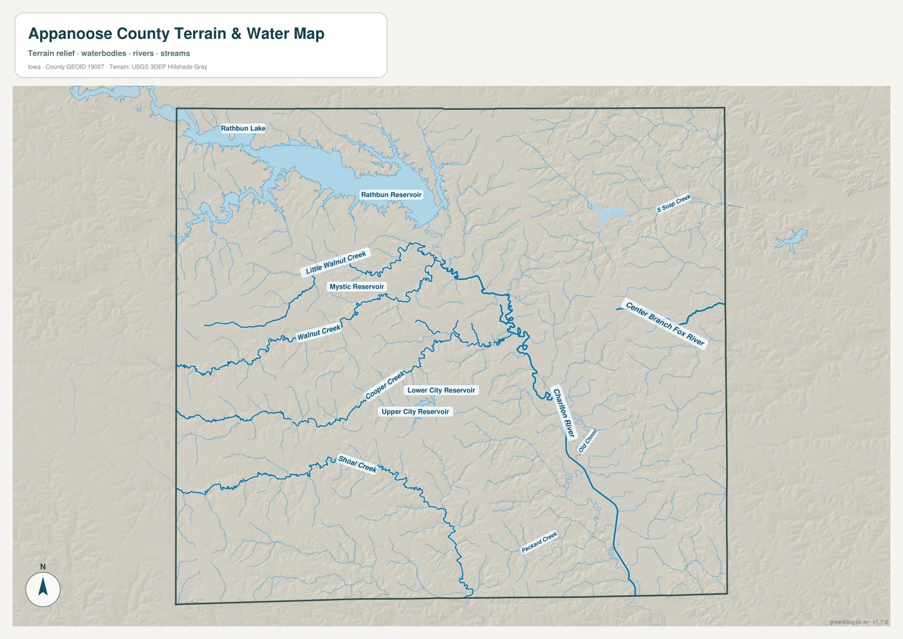
Near Centerville, the map labels Upper City Reservoir and Lower City Reservoir. Appanoose County Conservation describes Lelah Bradley on the southwest side of Centerville as a park with upper and lower reservoirs used for fishing and boating. These smaller waters are useful geographic markers because they sit close to the county’s main urban center, in contrast with the much larger Rathbun system to the north.
The Chariton River forms the main named river corridor in the central-eastern part of the map and continues southward through the county. Center Branch Fox River reaches in from the east, Soap Creek is labeled in the northeast, and Shoal Creek creates a long drainage route across the southern half. Packard Creek appears farther south, while an Old Chariton channel is labeled near the main river. Instead of one broad valley controlling the whole county, the map shows many smaller tributary valleys feeding into larger channels.
This layer is a geographic reference map, not a floodplain, parcel, legal-boundary, or navigation product. A blue line shows the mapped position of a stream, not whether a property is currently at flood risk or whether the channel is open to boating. Rathbun Lake levels, recreation rules, access conditions, and flood information can change, so current decisions should rely on the responsible agencies rather than this county-scale illustration.
The 230–330 meter surface separates river lowlands from western uplands
The elevation map gives Appanoose County an actual mapped range of roughly 230 to 330 meters, with a mean near 291 meters. Greens mark lower terrain and tan-to-brown colors represent higher land. The most continuous low corridor runs from the northern interior through the center and toward the southeast, matching the broader Chariton River drainage seen on the water map. Smaller green branches extend away from that corridor wherever tributaries have cut into the uplands.
The west and southwest contain broader areas of higher orange and brown terrain. Even there, however, the surface is broken by narrow low valleys. Around Cincinnati and Exline, small drainage lines repeatedly divide the upland. Northwest of Centerville, the terrain drops toward the Rathbun Lake basin and the tributaries feeding the reservoir. The county therefore reads as rolling, dissected land rather than a single smooth slope.
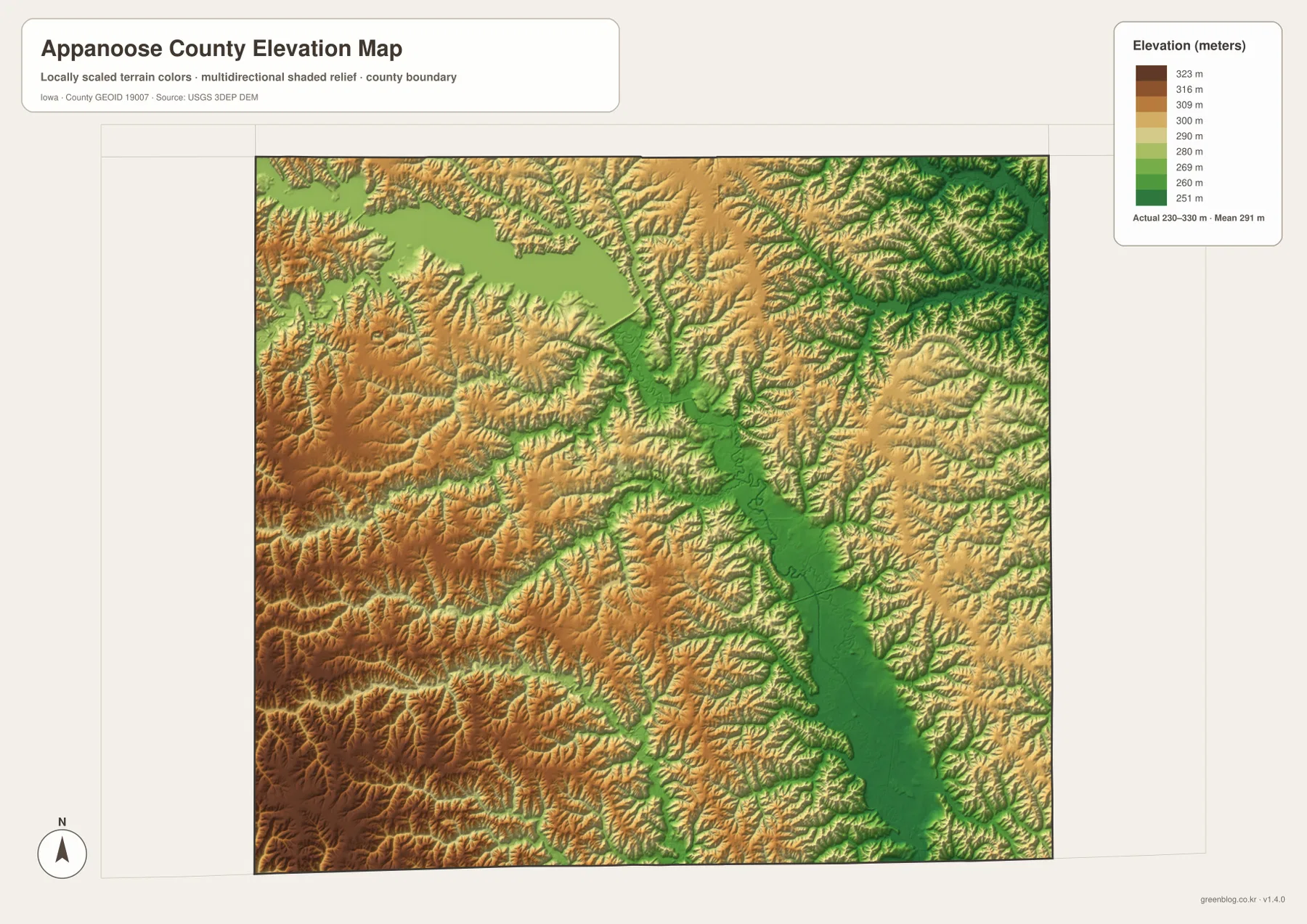
The central lowland is easiest to understand when compared with the water map. The Chariton River and the city-reservoir area occupy the same broad zone that appears greener on the elevation surface. Tributaries from the east and west form smaller low fingers reaching into higher land. This is why the straight rural roads on the general map should not be mistaken for evidence of flat terrain; the roads cross a landscape that contains many short ridges and hollows.
The colors are scaled to make differences within this county visible, so they should not be compared directly with the color palette of another county map. The surface is also generalized for county-scale interpretation. It is useful for distinguishing low valleys from higher uplands, but it is not survey-grade or engineering-grade elevation data and should not be used to set construction elevations, property grades, or precise slope measurements.
Comparing lake, city, and relief layers reveals the county more clearly
Centerville changes meaning depending on the layer. On the general map it is the road and service center. On the city map it is the largest of the six highlighted communities. On the water map it sits near small reservoirs and tributaries, with the Chariton River farther east. On the elevation map, those nearby channels become lower green corridors surrounded by somewhat higher ground. Comparing the layers turns a single city symbol into a much fuller picture of how the community sits within the landscape.
Rathbun Lake benefits from the same comparison. The general map places the lake relative to Moravia, Rathbun, Mystic, and Centerville. The water map reveals the reservoir’s branching shoreline and associated tributaries. The elevation layer shows the lower basin and the ridges rising around it. No one layer needs to carry every label; the three views work together to show location, water shape, and terrain.
The Chariton River is another strong cross-map feature. Once the river is identified on the water layer, the elevation map shows a long low corridor in nearly the same position. Returning to the general map then shows how roads and communities relate to that lower ground. Appanoose County Conservation’s description of Sharon Bluffs east of Centerville above the Chariton River also fits the terrain contrast visible in this part of the county.
The six-city map can look almost evenly spaced at first glance, but the terrain layers show what lies between those points. Moravia is tied to the Rathbun Lake side of the county, Mystic sits among reservoir and creek country, Moulton and Unionville lie east of the main Centerville cluster, and Cincinnati stands in the more elevated southwest. Those differences are what keep the page county-specific instead of reducing it to a generic list of road and map types.
Pick the layer that matches the question you are asking
Use the general county map first when you need roads, communities, boundaries, and streams together. It is the easiest layer for locating Centerville, following the direction toward Moravia or Moulton, and seeing where smaller communities such as Plano, Numa, Exline, Rathbun, and Udell sit. It also gives the best overall introduction to how the road network fits around the water features.
The city distribution map is better when the six highlighted communities are the subject. It removes most secondary detail so Centerville, Moravia, Moulton, Cincinnati, Mystic, and Unionville stand out immediately. The water layer should be the first choice for Rathbun Lake, Mystic Reservoir, the city reservoirs, the Chariton River, and named creeks. The elevation layer is most useful after a stream or lake has already been located and you want to see the low valley or surrounding upland.
For teaching or printed reference, combining two or three layers often works better than forcing everything onto one page. A Rathbun Lake explanation can begin with the general map for place names, move to the water map for shoreline and tributaries, and finish with the elevation map for the basin and surrounding ridges. A Centerville-focused explanation can start with the city and general maps, then add the water map to show the upper and lower city reservoirs and the nearby Chariton drainage.
The downloadable archive contains the original high-resolution JPG files corresponding to the general county map, city distribution map, terrain-and-water map, and elevation map shown above. Each image is 3638 by 2572 pixels, giving more detail than the WebP previews embedded in the article. Review the maps on the page first, then use the full files when you need larger text, closer inspection, printing, or offline reference.
Three limits are important when using these maps
First, the road and city maps are orientation tools, not live navigation products. Rural roads can be affected by construction, temporary closures, maintenance, or weather, and not every minor road appears at the same level of detail. Use the map to understand the direction between communities, then check current routing information before making a trip.
Second, the water layer does not show flood risk, property ownership, legal access, channel depth, or navigability. A stream or reservoir can be mapped accurately for geographic context without answering any of those questions. Current Rathbun Lake levels, park operations, boating rules, fishing regulations, and flood conditions should be checked through the appropriate agencies.
Third, the 230–330 meter elevation range describes generalized county-scale terrain. It is excellent for distinguishing the Chariton lowland from higher western ground and for seeing where tributary valleys branch through the uplands, but it cannot replace a site survey or engineering data. The safest use is comparative: identify lower and higher parts of the county, then connect those patterns with named rivers, reservoirs, roads, and cities on the other maps.
Appanoose County is particularly well suited to this layered approach because its strongest geographic features are not all visible on one map. Centerville’s road network, Rathbun Lake’s branching shoreline, the Chariton River corridor, smaller city reservoirs, and the western uplands each become clearer on a different layer. Choosing the map that fits the question produces a much more useful picture than trying to treat every blue line, road, city, and color band as equal.
Frequently Asked Questions
Which map is best for seeing Rathbun Lake and the Chariton River together?
The terrain-and-water map is the best starting point because it labels Rathbun Lake, Rathbun Reservoir, the Chariton River, Mystic Reservoir, and several named creeks on one layer. Add the elevation map when you want to see the low valleys and surrounding uplands, and use the general map when you also need Moravia, Centerville, roads, and other communities.
Where are the Upper City Reservoir and Lower City Reservoir shown near Centerville?
Both are labeled on the terrain-and-water map near Centerville. Appanoose County Conservation also describes Lelah Bradley on the southwest side of Centerville as an area with upper and lower reservoirs. The map is useful for geographic orientation, but current access, boating, fishing, and water-level information should be checked separately.
What is included in the downloadable ZIP?
The ZIP contains four high-resolution JPG files matching the general county map, city distribution map, terrain-and-water map, and elevation map shown in the article. Each file is 3638×2572 pixels, providing more detail for printing or close viewing than the WebP previews on the page.
Map File Information
Download the Appanoose County maps shown in this article as high-resolution JPG files.
- Printable Size: 3638×2572 pixels each
Related Maps
Sources and references
- Appanoose County Government — county offices and local information centered in Centerville
- Appanoose County Conservation — Sharon Bluffs, Lelah Bradley, and Chariton River-area conservation information
- U.S. Army Corps of Engineers – Rathbun Lake — Rathbun Lake, the Chariton River system, and project information
- Iowa Department of Transportation – Appanoose County Maps — county and city road-map references
- USGS National Hydrography — hydrography reference
- USGS 3D Elevation Program — elevation reference
Green Map creates custom-edited map images using open geographic data sources such as geoBoundaries, Natural Earth, OpenStreetMap, and government open data.
These maps are edited visual materials, not raw data files, and are provided for education, documents, presentations, and graphic reference.