White County is a largely rural county in northwestern Indiana where small towns, broad stretches of open land, and the Tippecanoe River system are easy to separate once you know the main landmarks. Monticello, the county seat, sits a little east of the county’s center near the junction of U.S. 24 and U.S. 421. Monon lies to the north, Wolcott and Reynolds are farther west, and Brookston and Chalmers mark the southern half. Those communities are spread far enough apart that roads and waterways matter just as much as town labels when you are trying to understand the county.
The page includes a general county map, a simplified city distribution map, a terrain-and-water map, and an elevation map. The four views are shown as lighter WebP images in the article, while the download box near the end contains the matching high-resolution JPG files in one ZIP archive. The maps are most useful when treated as separate tools: the first handles roads and boundaries, the city index isolates settlement locations, the water map follows the Tippecanoe River and named tributaries, and the elevation view shows the contrast between lower river corridors and higher western ground.
Table of Contents
Start with Monticello to make sense of the road pattern
Monticello is the easiest place to orient yourself on the general county map. U.S. 24 runs east-west through Wolcott and Reynolds before reaching Monticello and continuing toward Idaville and Burnettsville. U.S. 421 approaches from the north and passes the Monticello area, while the White County Comprehensive Plan also identifies the city as the county seat at the meeting of those two major highways. Once that junction is located, the rest of the county’s road layout becomes much easier to follow.
The southern half has a different set of references. State Road 43 runs through the Chalmers and Brookston area, State Road 18 crosses near Brookston, and I-65 cuts diagonally across the southwest. U.S. 231 is visible in the western part of the county, while Monon and Buffalo sit apart from the Monticello road cluster in the north. The map also labels neighboring counties around the edge—Jasper, Pulaski, Cass, Carroll, Tippecanoe, and Benton—so it is possible to see where White County roads continue beyond the boundary.
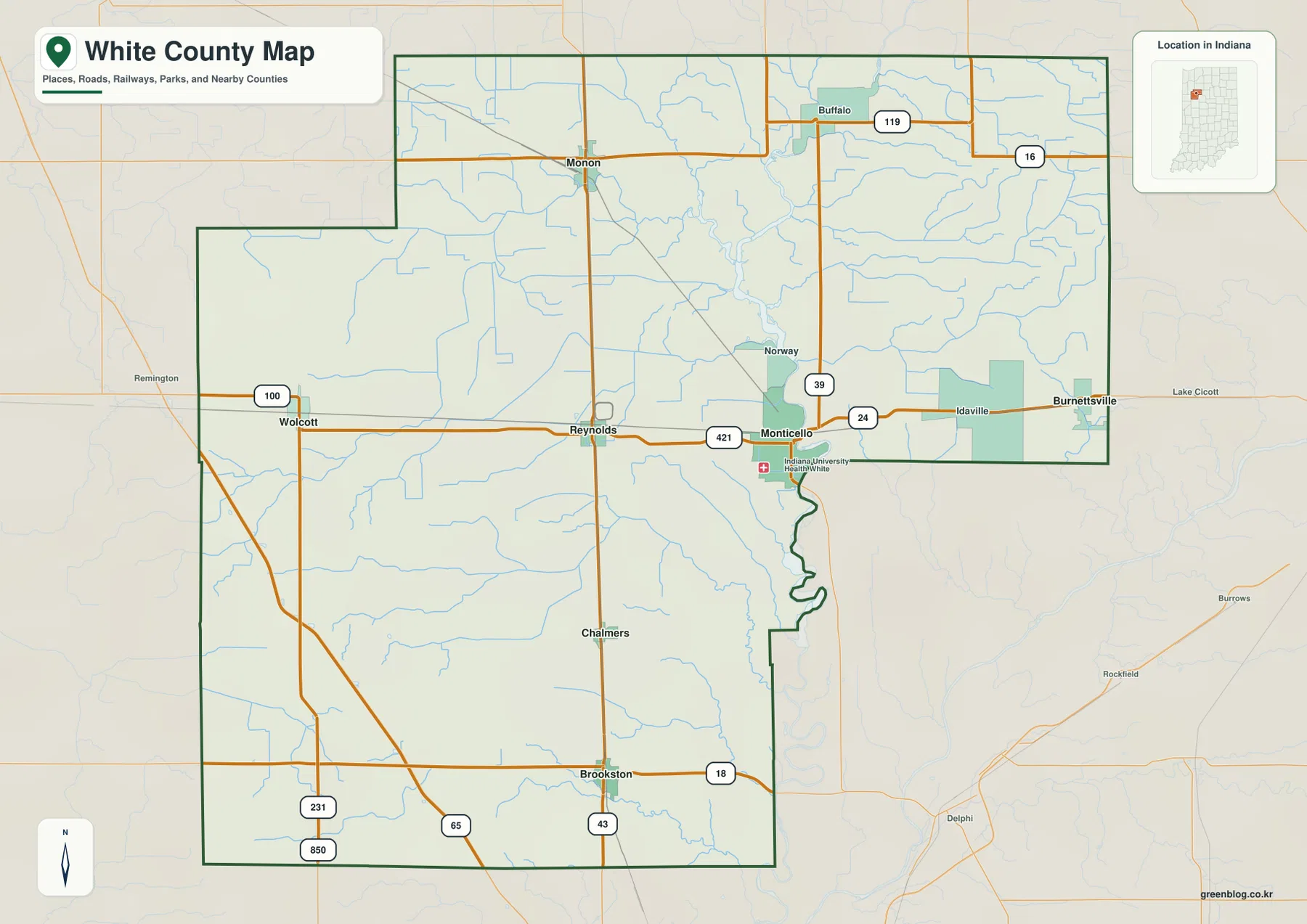
The county outline itself is worth noticing because it is not a simple rectangle. The northwest side steps inward, the southeast edge changes direction, and the boundary south of Monticello follows a long irregular section near the Tippecanoe River. Those bends help explain why some nearby places appear close to White County but sit outside it. For route planning or a basic county overview, this general map gives the clearest combination of boundary, roads, towns, rail lines, and water.
The main towns are separated by wide rural gaps
The city distribution map removes much of the road and terrain detail and concentrates on six communities: Monticello, Monon, Brookston, Wolcott, Reynolds, and Chalmers. Monticello is near the east-central part of the county, Monon is well to the north, Wolcott sits near the western edge, and Brookston is close to the southern boundary. Reynolds lies between Wolcott and Monticello along the U.S. 24 corridor, while Chalmers is north of Brookston along the State Road 43 side of the county.
That spacing says a great deal about White County without requiring a population table. The county is not a continuous urban area with suburbs filling the space between towns. Instead, its communities are distinct points separated by farmland, smaller roads, creeks, and open rural land. Monticello is the administrative center, but Monon is a better reference for the north, Wolcott and Reynolds frame much of the west, and Brookston and Chalmers make the southern part easier to read.
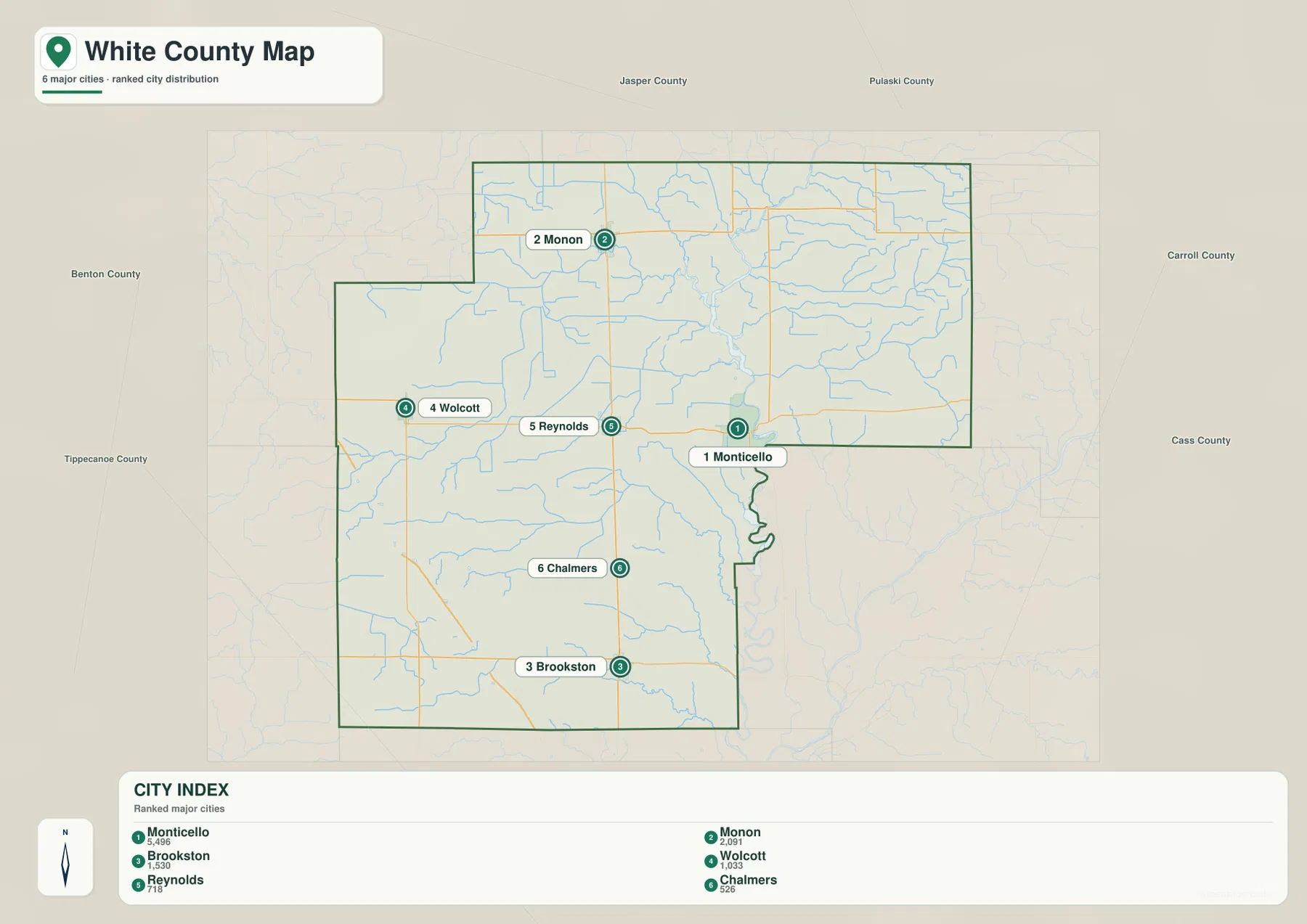
The map also keeps the names of surrounding counties outside the White County outline. Jasper and Pulaski are to the north, Carroll and Cass are to the east, Tippecanoe is to the south, and Benton is to the west. That outer frame is useful when a place description needs more than “north” or “south” inside the county. It shows which neighboring jurisdiction a traveler would reach after leaving each side of White County.
The Tippecanoe River forms the strongest water corridor
The terrain-and-water map shifts attention away from highways and toward the drainage network. The Tippecanoe River enters from the north, runs through the eastern half of White County, passes the Monticello area, and continues south along a winding course. Honey Creek reaches toward the river from the west, Pike Creek approaches from the east, and Big Creek and Spring Creek cross the southern half. These larger named streams are joined by many smaller channels that give the eastern side of the county a much denser water pattern than the general road map suggests.
Several local names appear around the river north of Monticello, including Hoagland Bay, Keans Bay, and Honey Creek Bay. The map also labels Keans Creek, McKillip Ditch, Hoagland Ditch, Timmons Ditch, and other smaller waterways. Their placement is useful for understanding how water reaches the Tippecanoe River, but the map should not be mistaken for a flood-risk product, boating chart, parcel map, or legal drainage record. It is a county-scale reference for the location and shape of visible waterways.
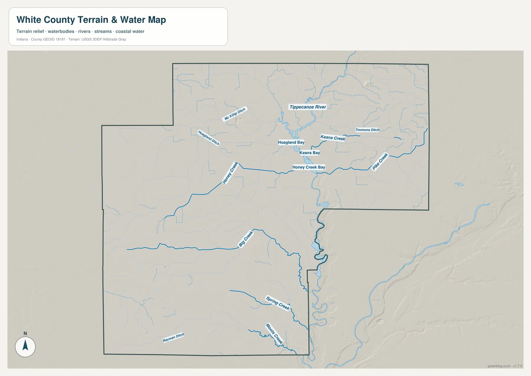
The shaded terrain behind the blue water lines adds another clue. The main river occupies a lower, more clearly cut corridor, and smaller tributaries follow their own shallow valleys toward it. South of Monticello, the river bends repeatedly near the county boundary before continuing beyond White County. Seeing the water network this way makes the county’s eastern geography easier to understand than a list of stream names would.
Elevation colors separate the river lowlands from higher western ground
White County does not have mountainous relief, yet the elevation map shows a clear internal difference. Darker green follows much of the Tippecanoe River corridor, especially through the eastern half and south of Monticello. Warmer yellows and browns become more common toward the west and southwest. The result is a gentle but readable transition from low ground along the river to somewhat higher land across the western side of the county.
The legend marks an average elevation of about 211 meters and uses a locally scaled color range to make subtle differences easier to see. Those colors are best read comparatively rather than as survey measurements at a particular address. A parcel, construction site, drainage project, or engineering decision requires original elevation data or a professional survey. Here, the value of the map is showing where the low river corridor sits in relation to the broader landscape.
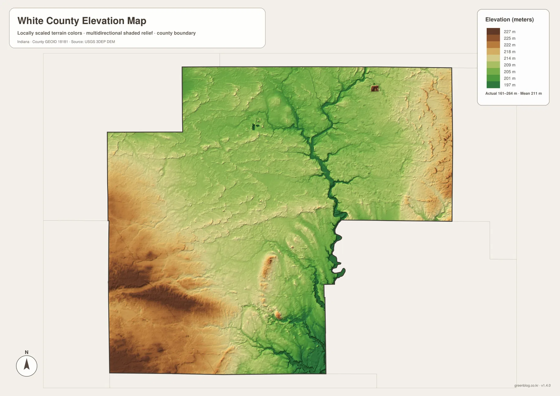
Comparing the elevation and water maps makes the pattern especially clear. The Tippecanoe River and several tributary valleys line up with lower colors, while western White County around the Wolcott side contains broader areas of higher shading. The southern area around Brookston and Chalmers is not perfectly level either; small creek valleys interrupt otherwise gentle terrain. The county remains relatively low-relief overall, but those local changes are large enough to shape the map.
Lake Shafer and Lake Freeman give Monticello a distinctive setting
Monticello’s relationship with water extends beyond the river line shown on the maps. Local tourism information identifies Lake Shafer north of the city and Lake Freeman to the south as two major recreation areas tied to the Tippecanoe River. Norway Dam separates the two lakes, so they belong to the same river system without functioning as one uninterrupted boating route. That north-south arrangement helps explain why Monticello appears so closely connected with both transportation and water in White County descriptions.
On the general map, Monticello is already important because U.S. 24 and U.S. 421 meet there. Add the river and the lake corridor, and the city becomes the most practical starting point for explaining the county to someone who has never seen it before. The other principal towns are more widely separated across agricultural and rural land, which makes their road connections easier to understand after Monticello has been located.
The U.S. Census Bureau lists 505.14 square miles of land area for White County. County planning material describes much of the area outside Monticello as rural, which matches the spacing visible between the major communities. A city index alone leaves that open land almost blank, while the road, water, and elevation maps fill in the connections between towns. Together they show why distance, river corridors, and highway direction are central to reading White County.
Pick the map that matches the detail you need
If the task is to show county boundaries, highways, towns, and nearby counties in one frame, begin with the general county map. It is the clearest choice for tracing U.S. 24 across the county, locating U.S. 421 at Monticello, or seeing I-65 in the southwest. When the only question is where Monticello, Monon, Brookston, Wolcott, Reynolds, and Chalmers sit relative to one another, the city distribution map removes enough detail to make that comparison faster.
For the Tippecanoe River, Honey Creek, Big Creek, Spring Creek, Pike Creek, or the smaller named channels, the terrain-and-water map carries the most relevant labels. The elevation map is the better choice when the point is the lower river corridor and the higher colors toward western and southwestern White County. Using one map for the main message and a second for supporting detail usually keeps a presentation or article clearer than trying to make every feature equally prominent at once.
The WebP images in the article are sized for web viewing. The ZIP archive below contains the corresponding original JPG files at 3638×2572 pixels, with the county map, city map, terrain-and-water map, and elevation map stored separately. They can be opened or edited individually without extracting a map from a combined sheet. For legal boundaries, surveyed elevations, flood decisions, navigation, or other official uses, consult the current agency data listed in the source section rather than relying on these county-scale reference graphics.
Frequently Asked Questions
Why is Monticello the best starting point on a White County map?
Monticello is the county seat, sits near the junction of U.S. 24 and U.S. 421, and lies close to the Tippecanoe River and the Lake Shafer–Lake Freeman corridor. Once Monticello is located, Monon is clearly north, Wolcott and Reynolds are west, and Chalmers and Brookston are south. Use the general county map for roads and boundaries, then switch to the terrain-and-water map when the river and lake setting is the main subject.
Why does the Tippecanoe River corridor look lower on the elevation map?
The river occupies a lower corridor that appears in darker green through much of eastern White County and around Monticello. Tributary valleys connected with streams such as Honey Creek, Big Creek, and Spring Creek also form lower bands. Western and southwestern parts of the county show broader areas of higher color. The map is intended for county-scale comparison, not for reading a survey-grade elevation at a specific property.
What files are included in the White County download ZIP?
The archive contains four separate JPG images: the general county map, the city distribution map, the terrain-and-water map, and the elevation map. Each file measures 3638×2572 pixels. The article uses lighter WebP versions for faster page loading, while the downloadable JPG files retain the larger original dimensions for offline viewing or editing.
Map File Information
Download the White County maps as high-resolution JPG files in one ZIP archive. The county, city, terrain-and-water, and elevation maps are stored as separate original images.
- Printable Size: 3638×2572 pixels each
- File Type: ZIP containing 4 JPG files
Related Maps
Sources and references
- White County Comprehensive Plan – official county context for Monticello, transportation, rural settlement, and the lakes
- Enjoy White County – local information for Monticello, Lake Shafer, Lake Freeman, and recreation
- Indiana Natural Resources Commission: Navigable Waterways by County – Tippecanoe River waterway information for White County
- U.S. Census Bureau QuickFacts: White County, Indiana – county land area and population statistics
- USGS National Hydrography – national surface-water and hydrography reference data
- USGS 3D Elevation Program – elevation data and program documentation
Green Map creates custom-edited map images using open geographic data sources such as geoBoundaries, Natural Earth, OpenStreetMap, and government open data.
These maps are edited visual materials, not raw data files, and are provided for education, documents, presentations, and graphic reference.