Vermillion County is a long north–south county on Indiana’s western side, with most of its lowest ground following the Wabash River edge to the east and broader uplands rising toward the west. Clinton anchors the south, Cayuga and Newport provide central-eastern references, Perrysville lies farther north, and Dana sits well inland to the west. The physical maps add Vermillion River, Little Vermillion River, Spring Creek, southern tributaries, and a relief surface ranging from about 140 to 209 meters. This Vermillion County Map page brings those roads, towns, waterways, and elevation differences together. You can download the four 2572×3638 high-resolution JPG originals in one ZIP below for close inspection or A3 printing.
Clinton and Cayuga are useful fixed points because they sit at different parts of the eastern lowland. Clinton is near Routes 63 and 163 in the south, while Cayuga is farther north near the roads marked 234 and 100. Perrysville is near the Route 32 and 150 area in the north, and Dana is separated to the west near Route 36. The result is a county where the main communities stretch over a long distance rather than forming one compact cluster.
The elevation view explains why the eastern and western halves look so different. Its legend reports an actual range of about 140 to 209 meters and a mean of 178 meters. Green low ground follows the Wabash River side and broadens around Cayuga, Newport, and Clinton, while tan and brown terrain becomes dominant toward the western interior. Vermillion River and Little Vermillion River cut green corridors through those uplands before reaching the lower eastern side.
Table of Contents
A long road pattern connects Perrysville, Cayuga, Newport, and Clinton
The general county map is easiest to understand by following the eastern half from north to south. Perrysville appears in the north near Route 32 and the road marked 150. Farther south, Cayuga sits near Routes 234 and 100, with Newport below it along the irregular eastern boundary. Clinton anchors the southern end near Routes 63 and 163.
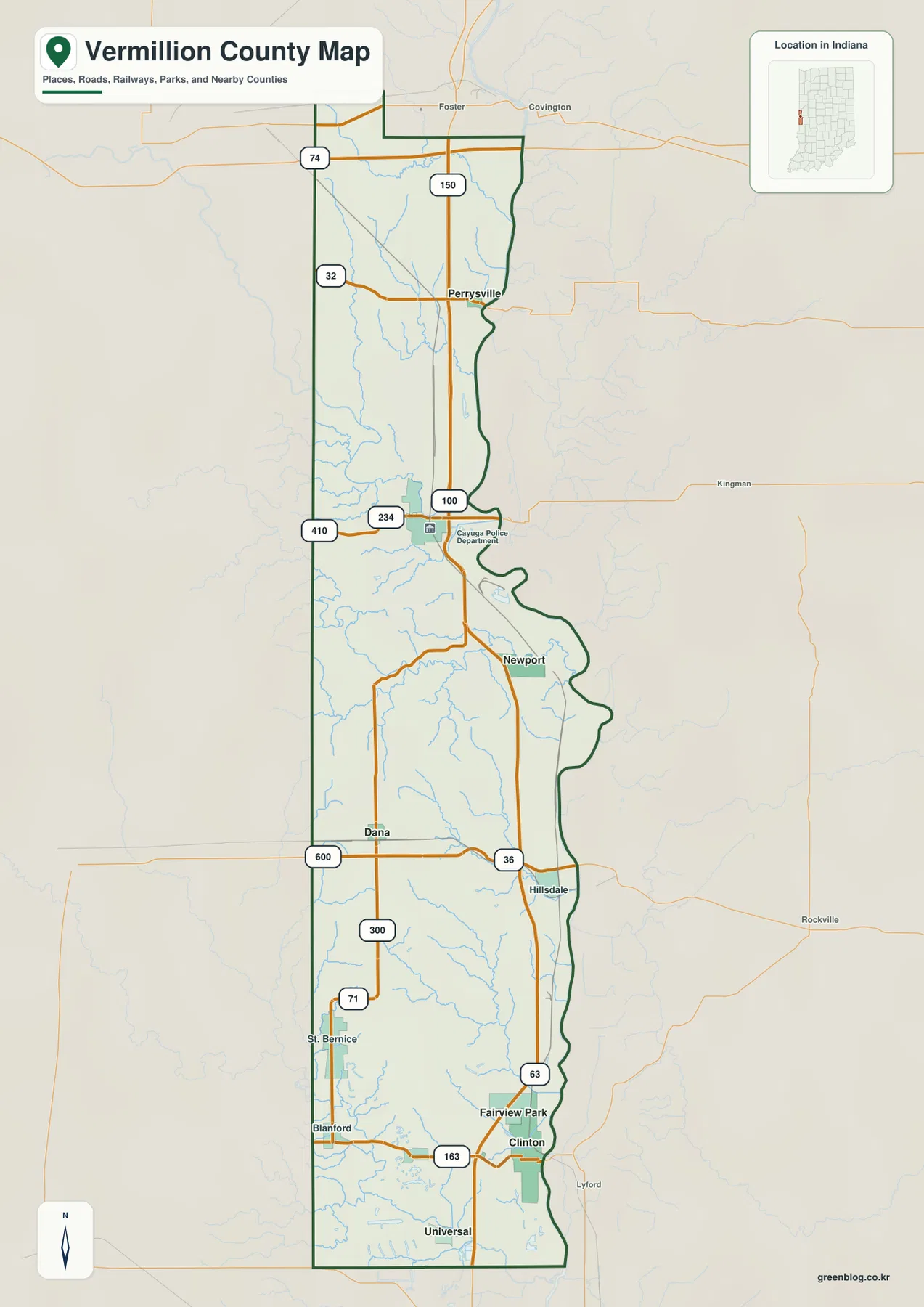
The Cayuga area includes roads marked 234, 100, and 410, making it an easy middle reference. Newport lies farther south beside the winding eastern edge, which closely follows the county’s low river side. These communities are separated by significant north–south distance, reinforcing the county’s long shape.
Dana lies farther west near Route 36, with Hillsdale on the eastern side of the same broad east–west road. South of Dana, the road marked 300 approaches St. Bernice and Blanford. This western interior sits higher than the Wabash side, so the road network crosses a more dissected surface even when the map itself looks relatively simple.
Route 74 appears near the northern boundary, while the Clinton–Universal area provides the final southern road references. Use this map for county-scale orientation and relative road positions; temporary construction, closures, and changing traffic restrictions should be checked with a current transportation source.
The six highlighted communities stretch from Clinton to Perrysville
The city view highlights Clinton, Fairview Park, Cayuga, Dana, Perrysville, and Newport. Clinton and Fairview Park form the southern pair, Cayuga and Newport occupy the central-eastern portion, Perrysville is isolated farther north, and Dana stands apart in the western interior. This distribution makes the county’s long shape clearer than the detailed road map does.
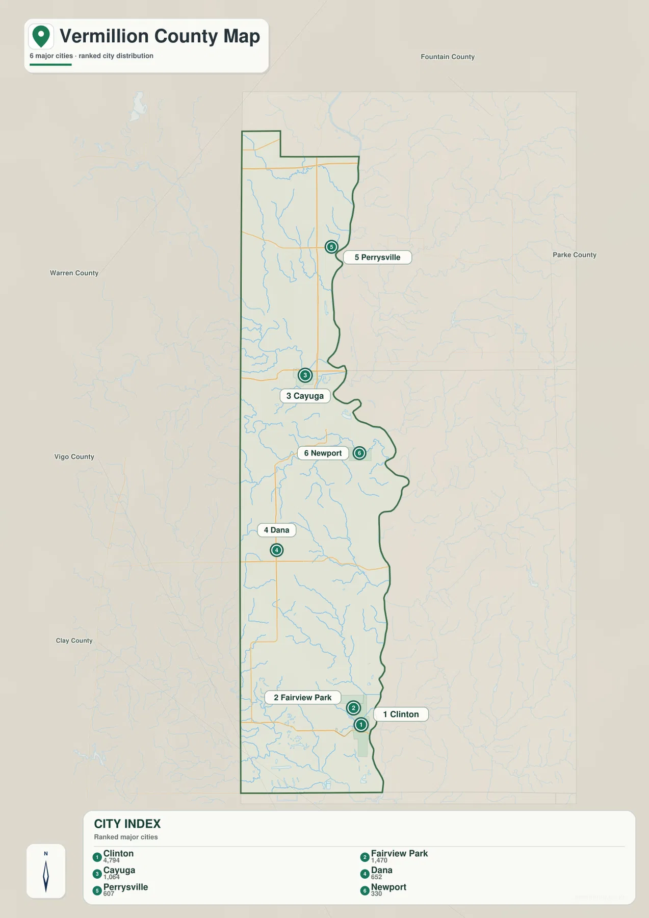
The CITY INDEX prints numeric values beside the six names, but the supplied graphic does not state their statistical year or provide a separate source. This page therefore does not present those figures as current official population. A recent U.S. Census release should be used when current population counts are needed.
Fountain, Parke, Warren, Vigo, and Clay county names appear around the outside of the city view. Those surrounding labels reinforce how far Vermillion County extends from its northern end to the Clinton area in the south. They also make the different outer positions of Perrysville, Dana, and Clinton easier to understand.
The settlement pattern is closely tied to the water network. Vermillion River crosses the northern interior toward the Wabash side, while Little Vermillion River occupies a separate valley farther south. In the southern half, Norton Creek, Feather Creek, and Brouilletts Creek cut through the higher ground before descending toward the eastern lowland.
Vermillion River and Little Vermillion River cut separate valleys through the interior
Spring Creek is one of the first named waters in the north, with Coal Branch and Jordan Branch visible farther south. Vermillion River then becomes the dominant northern river, bending through the interior and heading toward the lower eastern side. Its valley is easy to recognize again on the elevation map because it appears as a green corridor within higher western terrain.
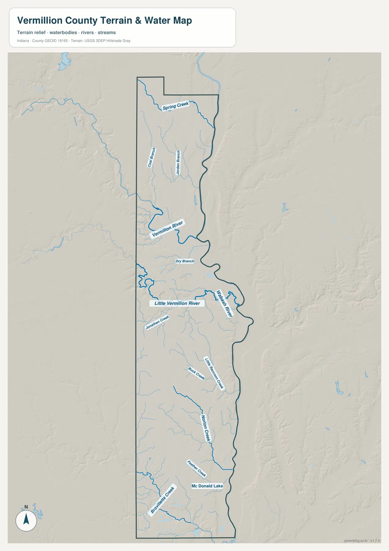
Little Vermillion River occupies a separate central valley south of Vermillion River. Dry Branch and Jonathan Creek are also labeled in this part of the county. The similar names can be confusing, but the map clearly shows Vermillion River and Little Vermillion River as two distinct waterways rather than one channel.
The southern half includes Little Raccoon Creek, Buck Creek, Norton Creek, Feather Creek, and Brouilletts Creek. McDonald Lake is labeled near the lower part of the county as a compact inland water reference. Together, these features show that the western uplands are cut by many smaller valleys even where no large river is present.
Use this hydrology view to locate Vermillion County rivers, creeks, and McDonald Lake at county scale. It is not intended to define flood limits, parcel boundaries, legal water lines, channel depth, or navigation conditions; those questions require current agency data created for those purposes.
The 140–209 meter surface drops from western uplands into the Wabash lowland
The elevation legend gives Vermillion County an actual range of about 140 to 209 meters and a mean of 178 meters. The eastern edge is dominated by green low terrain associated with the Wabash River corridor, while the western and southwestern interior contains much more tan and brown high ground. The county’s elongated shape makes this west-to-east contrast visible over a large distance.
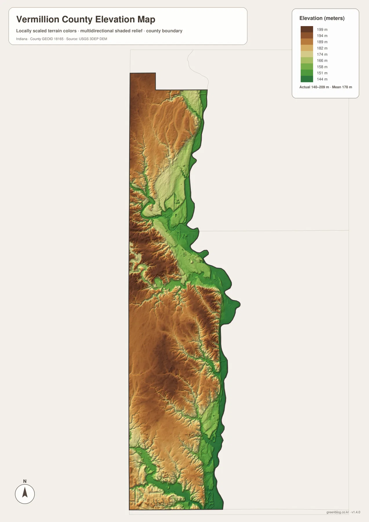
The northern western uplands are deeply cut by Vermillion River and smaller branches. Those valleys appear as narrow green paths through the brown surface. Farther south, Little Vermillion River forms another clear low corridor that descends toward the Wabash side.
The southwestern uplands are also dissected by Norton Creek, Feather Creek, Brouilletts Creek, and other tributaries. Clinton and the eastern boundary return to broad lower terrain, so the overall surface combines a wide eastern valley with higher western ground broken by many stream-cut hollows.
The relief image is intended for broad comparison across Vermillion County rather than surveyed point elevations. If you need the exact elevation of a building, road point, field, or parcel corner in Vermillion County, use the underlying elevation data or a professional survey rather than this overview.
Use Clinton and Cayuga as fixed points when comparing roads, rivers, and elevation
For basic orientation, start with Clinton and Cayuga, then identify Routes 63, 36, and 150. The city map is cleaner when the goal is simply to compare Perrysville, Newport, Dana, and Fairview Park within the long county shape. Once those places are familiar, the detailed road map becomes much easier to scan.
For the physical landscape, find Wabash River, Vermillion River, and Little Vermillion River before moving to the smaller southern creeks. Then open the elevation map at the same locations. The eastern river corridor remains low and green, while the western uplands rise higher and are cut by the same stream valleys.
The page uses smaller WebP previews for quick browser viewing. For Vermillion County, the ZIP preserves the four full-resolution JPG originals—general county, city, terrain-and-water, and elevation—at 2572 by 3638 pixels each. These originals are better suited to A3 output and close inspection of route numbers or creek labels.
A practical comparison routine is to keep Clinton as the southern reference and Cayuga as the central-northern reference, trace the major rivers on the water view, and finish by comparing the green eastern lowland with the higher brown western interior.
Frequently Asked Questions
Are Vermillion River and Little Vermillion River the same waterway?
No. The supplied water map shows Vermillion River in the northern part of the county and Little Vermillion River in a separate valley farther south. Both descend toward the lower Wabash side, but they are mapped as distinct rivers.
Do the numbers in the city index represent current population?
The supplied city graphic does not identify a year or a separate statistical source for its numeric values, so this page does not present them as current official population. Use a recent U.S. Census release when current population figures are needed.
Where does the elevation map show the lowest broad terrain?
The widest low ground follows the Wabash River side along the eastern boundary, including the Cayuga, Newport, and Clinton side of the county. The legend reports an actual range of about 140–209 meters and a mean of 178 meters.
Map File Information
The ZIP contains four high-resolution JPG originals for Vermillion County: the general county map, city map, terrain-and-water map, and elevation map. Use these files when you need a closer look at route numbers, creek names, or when preparing an A3 print.
- Printable Size: 2572×3638 px each
Related Maps
Sources and References
The place, road, water, and elevation descriptions above are based on the supplied Vermillion County maps and asset information. The official references below can be used when more detailed boundary, hydrography, or elevation data are needed.
- U.S. Census Bureau TIGER/Line Shapefiles – official geometry for Vermillion County boundaries, roads, and named places
- USGS National Hydrography – source information for the Wabash, Vermillion, Little Vermillion, and other mapped waterways
- USGS 3D Elevation Program – elevation source information for the county relief surface
Green Map creates custom-edited map images using open geographic data sources such as geoBoundaries, Natural Earth, OpenStreetMap, and government open data.
These maps are edited visual materials, not raw data files, and are provided for education, documents, presentations, and graphic reference.