Pike County is organized around Petersburg in the north-central county, with Winslow farther south and Spurgeon near the southern edge. You can download the high-resolution JPG ZIP directly from this page. The larger originals make road shields, creek names, small lakes, and relief shading easier to read. This Pike County Indiana Map page combines the Petersburg road network, a three-place city connection map, the Patoka River system, and a 97–198 meter elevation surface that remains low across much of the north and west but rises strongly in the central and southeastern interior.
Petersburg is the easiest place to begin. It is the county seat and sits near the meeting of State Roads 56, 57, and 61, with Alford immediately to the east. Following Route 57 south leads through Glezen toward Winslow, while Otwell and Velpen provide eastern references and Spurgeon marks the long southern extension. State Roads 64, 257, 356, and 364 help organize the lower and eastern county where larger town labels become less frequent.
The terrain maps add an important second layer. Patoka River crosses the middle and eastern county through a broad lowland, and South Fork Patoka River creates another long valley in the south. Warner Lake, Grey Lake, and Enos Lake provide small fixed water references, while Flat Creek, Mud Creek, Bear Creek, and Prides Creek divide the interior. The elevation legend reports an actual range of about 97 to 198 meters and a mean of 147 meters, with the strongest high ground concentrated in the southeast and several shorter central ridges.
Table of Contents
Petersburg ties the northern roads to Winslow and the long southern county
Petersburg has the clearest developed footprint in the northern half of the general map. State Road 56 enters from the west, Route 61 continues north, and Route 57 heads south toward Glezen and Winslow. Because these roads meet near the county seat, Petersburg works well as a fixed reference before moving into the wider rural areas to the west or the more dissected terrain to the east.
West of Petersburg, Routes 56 and 65 cross a largely rural area with few large settlement labels. The northwestern boundary bends around several low drainage corridors, so road numbers and creek crossings matter more than town footprints. Alford, just east of Petersburg, is much smaller but is useful for confirming the transition out of the county-seat area along the eastbound road.
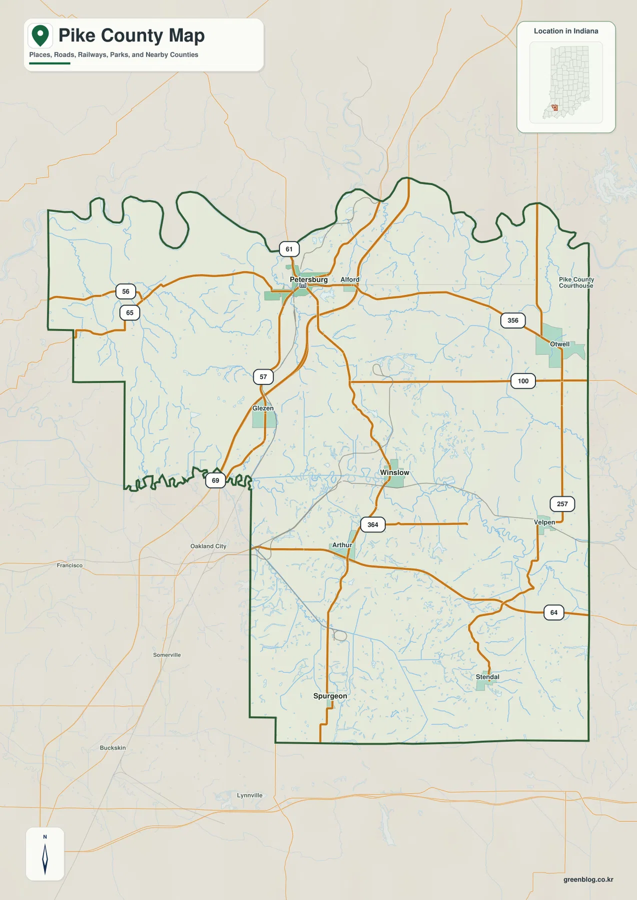
Otwell lies in the east near State Road 356, and Velpen appears farther south along Route 257. The road pattern here is more irregular than in the broad northern lowlands because short valleys and higher ridges repeatedly interrupt the surface. Matching these eastern roads with the elevation image makes the change from lower ground to hillier terrain much easier to recognize.
Winslow is the main southern settlement reference along Route 57, while Arthur is a smaller label farther south and west. Spurgeon sits close to the bottom of the county along the long north-south road corridor. Route 64 crosses the lower eastern county and Route 364 provides another interior east-west cue. Together, Winslow and Spurgeon make the county’s long north-south shape much easier to understand.
The connection map compares Winslow and Spurgeon directly with Petersburg
The supplied city connection map uses Petersburg as the hub at 2,414. Winslow is printed at 759 and about 8 miles away, while Spurgeon is printed at 163 and about 16 miles away. These are straight-line distances shown by the map rather than driving distances. The three places form a clear north-to-south sequence, which is useful for understanding how the county’s main settlement references stretch across its long vertical shape.
| Rank | Place | Value printed on map | Direct distance from Petersburg |
|---|---|---|---|
| 1 | Petersburg | 2,414 | Hub |
| 2 | Winslow | 759 | About 8 mi |
| 3 | Spurgeon | 163 | About 16 mi |
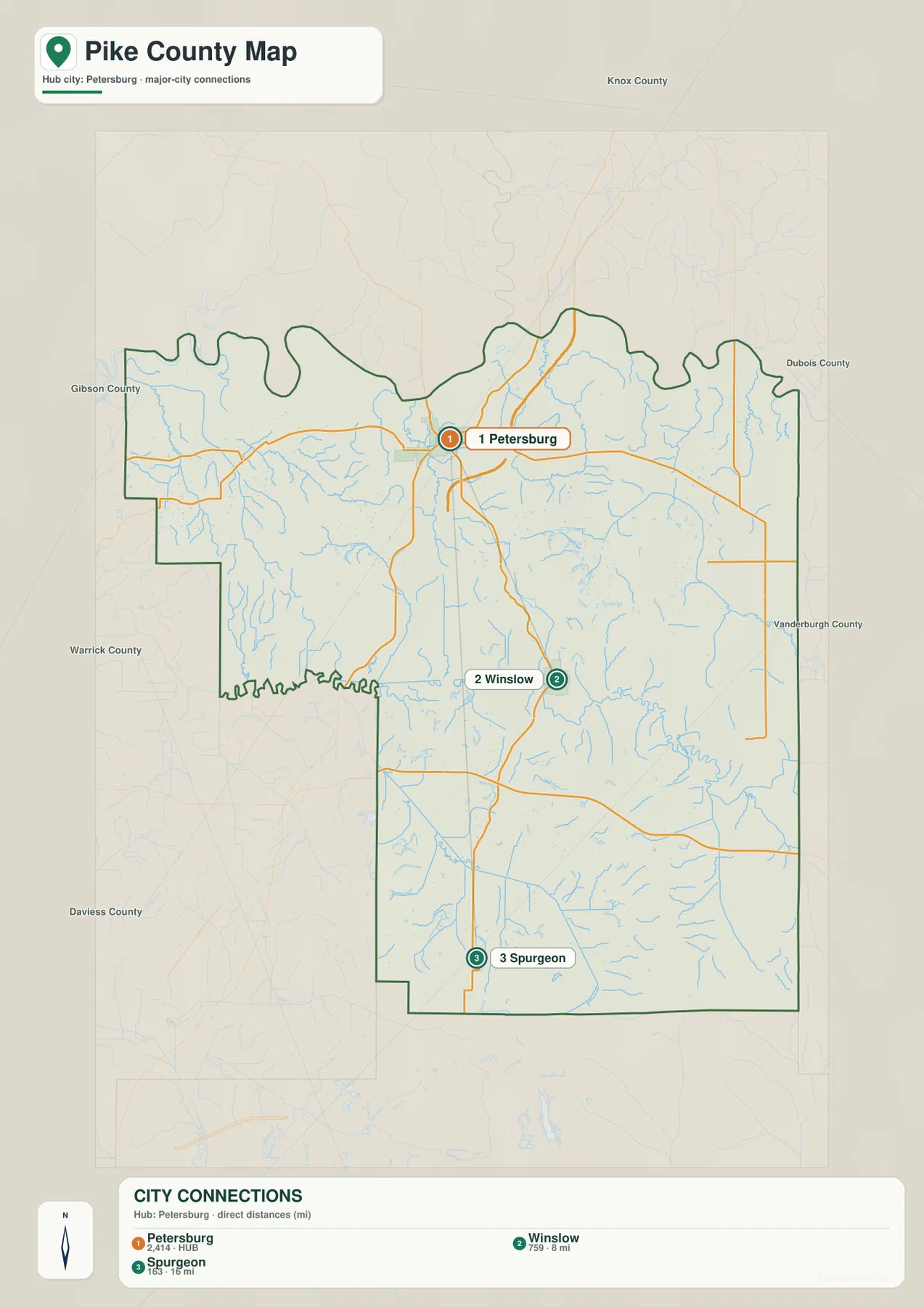
The connection map is intentionally simpler than the general county map. Alford, Glezen, Otwell, Velpen, and Arthur do not appear in the three-place ranking even though they are useful labels for countywide orientation. Use this view when the goal is to compare the principal north-south settlement references; return to the general map for the eastern and interior road network.
The Petersburg, Winslow, and Spurgeon values are the figures printed on this Pike County map edition, not live population counts. The 8- and 16-mile figures also should not be treated as driving mileage. Actual road distance depends on the route and exact start and end points, so navigation requires a current road-routing source.
Patoka River and South Fork create the county’s broadest low corridors
Patoka River is the strongest named drainage feature across the middle and east. It bends through a broad low corridor and collects many small creeks from the surrounding ridges. The U.S. Fish & Wildlife Service describes the Patoka River refuge as protecting one of the region’s notable bottomland forested wetland systems. That context fits the wide lowland visible on the supplied terrain-and-water map.
South Fork Patoka River forms a separate southern corridor. Grey Lake and Enos Lake provide small fixed landmarks nearby, while Cup Creek cuts another low route in the southeast. These features are useful on the elevation map because the drainage lines remain green while the adjacent southeastern ridges rise into much stronger yellow, tan, and brown terrain.
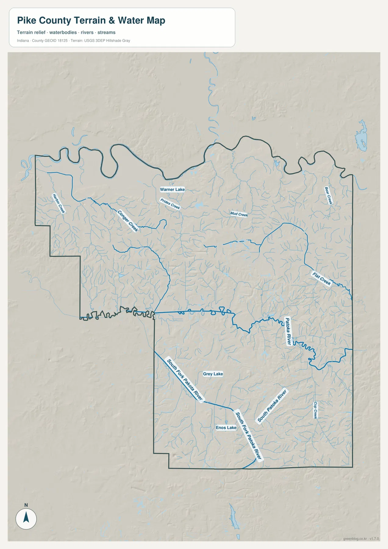
Warner Lake appears in the north-central interior near Prides Creek. Mud Creek crosses farther east, and Bear Creek provides another northeastern drainage reference. The northwestern county contains several additional low channels through broad, comparatively gentle ground. Pike County therefore does not read as one single river valley; the Patoka system is the main framework, but many smaller creeks and lakes subdivide the landscape.
Indiana DNR’s Pike State Forest information describes river access, floodplain forest, upland forest, and hillier trail sections near the Patoka River. The supplied water image is still intended only for geographic orientation and terrain comparison. Flood risk, current water levels or quality, navigation rights, property ownership, and legal stream boundaries require current agency or local information.
The 97–198 m relief rises from Patoka River lowlands into the central and southeastern ridges
The elevation legend gives an actual Pike County range of about 97 to 198 meters and a mean of 147 meters. Low terrain appears in green, while yellow, tan, and brown mark higher ground. Much of the north and west remains broadly low, while the middle contains short ridges and the southeast develops the strongest, most continuous high terrain on the map.
Patoka River creates a wide green corridor through the central county, and South Fork Patoka River forms another long lowland farther south. Numerous tributary cuts branch away from both rivers, so the surface can change from low green valleys to higher hills over short distances. This contrast helps explain why several roads between Petersburg, Winslow, and the eastern county bend with the terrain instead of following a simple grid.
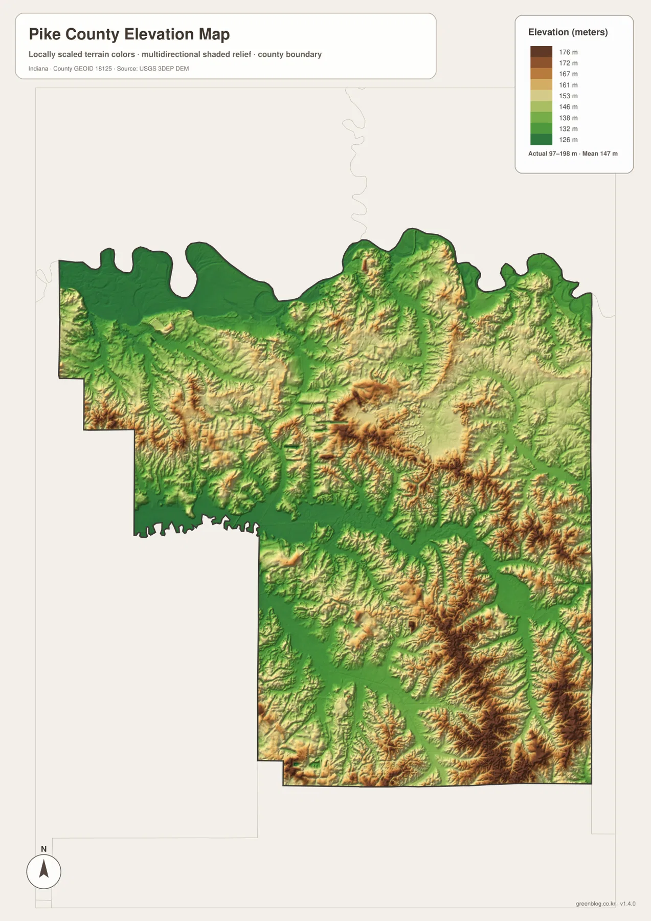
The central county contains several short tan and brown ridges separated by low tributary valleys. Farther southeast, the brown terrain becomes broader and more closely spaced, making that corner the most rugged-looking part of Pike County. The northwestern and northern edges are lower and gentler by comparison, although small drainage cuts still break the surface.
Pike State Forest trail information provides a useful local comparison because it describes both floodplain sections near the Patoka River and hillier upland terrain. This elevation image should still be treated as a countywide reference rather than an engineering surface. For a Pike County parcel, roadway grade, construction site, or drainage design, use original USGS elevation data or a qualified survey instead.
Keep Petersburg fixed while matching the Patoka River with Winslow and the higher southeast
For settlements and roads, begin with Petersburg near Routes 56, 57, and 61. Follow Route 57 through Glezen toward Winslow, add Spurgeon farther south, and then locate Alford, Otwell, and Velpen to the east. Routes 64, 257, 356, and 364 provide additional structure once the main north-south sequence is familiar.
The city connection map is best for comparing Petersburg, Winslow, and Spurgeon. It shows both the printed city values and the direct distances from the hub. For Alford, Glezen, Otwell, Velpen, Arthur, or the detailed road network, use the general map instead.
For terrain, locate Patoka River first and then add South Fork Patoka River, Flat Creek, Mud Creek, and Bear Creek. Switching to the elevation image at those same locations reveals the county’s main contrast: broad green river and creek lowlands separated by higher central ridges and an especially rugged southeastern interior.
The WebP images are reduced previews for faster page viewing. The Pike County archive contains four original 2572×3638-pixel JPG files covering the general county map, city connection map, terrain-and-water map, and elevation map. Use the larger originals when road shields, creek names, lake outlines, or ridge details need to remain legible in print.
A useful comparison is to keep Petersburg fixed as the northern reference. Find Winslow, Otwell, and Spurgeon on the general map, compare the three connection values, move to the water view to trace Patoka River and South Fork, and finish on the elevation image by comparing the broad lowlands with the higher central and southeastern ridges.
Frequently Asked Questions
Are the 8-mile and 16-mile city values driving distances?
No. The connection map labels Winslow at about 8 miles and Spurgeon at about 16 miles from Petersburg as straight-line distances. Driving mileage can be longer because it follows the actual road network and depends on the exact starting and ending points.
Which rivers and lakes are easiest to recognize?
Patoka River is the main central drainage reference and South Fork Patoka River defines a second southern lowland. Warner Lake, Grey Lake, and Enos Lake are useful smaller landmarks, while Flat, Mud, Bear, and Prides creeks divide the interior. Use the Pike County water image for orientation only; flood conditions, parcel limits, and legal stream boundaries require current official data.
Can the 97–198 m elevation range be used for exact site measurements?
No. The image gives a county-wide range with a mean of 147 meters and is intended for comparing river lowlands, tributary valleys, and higher ridges. For exact elevation on a Pike County parcel, construction site, road grade, or drainage project, use original terrain data or a qualified survey.
Map File Information
The Pike County ZIP combines the general road-and-place map, Petersburg connection map, terrain-and-water map, and elevation map as full-resolution JPG originals.
- File Type: ZIP containing four 2572×3638px JPG files
Related Maps
Sources and References
The article is based primarily on the supplied Pike County map set and asset manifest. The following official sources provide county, Petersburg, Patoka River, forest, boundary, hydrography, and elevation context.
- Pike County, Indiana – official county government and courthouse information in Petersburg
- U.S. Fish & Wildlife Service – Patoka River National Wildlife Refuge – official information on the Patoka River and associated floodplain forested wetlands
- Indiana DNR – Pike State Forest – official information on Patoka River access, bottomland forest, and upland terrain
- U.S. Census Bureau TIGER/Line Shapefiles – boundary reference for Pike County and its place framework
- USGS National Hydrography – reference data for Patoka River, creeks, and mapped lakes
- USGS 3D Elevation Program – source terrain data for precise elevation work beyond the county-scale relief image
Green Map creates custom-edited map images using open geographic data sources such as geoBoundaries, Natural Earth, OpenStreetMap, and government open data.
These maps are edited visual materials, not raw data files, and are provided for education, documents, presentations, and graphic reference.